

The Mount Errigal hike is a tough but hugely rewarding 4.5km trail that takes around 1.5 – 2 hours to complete.
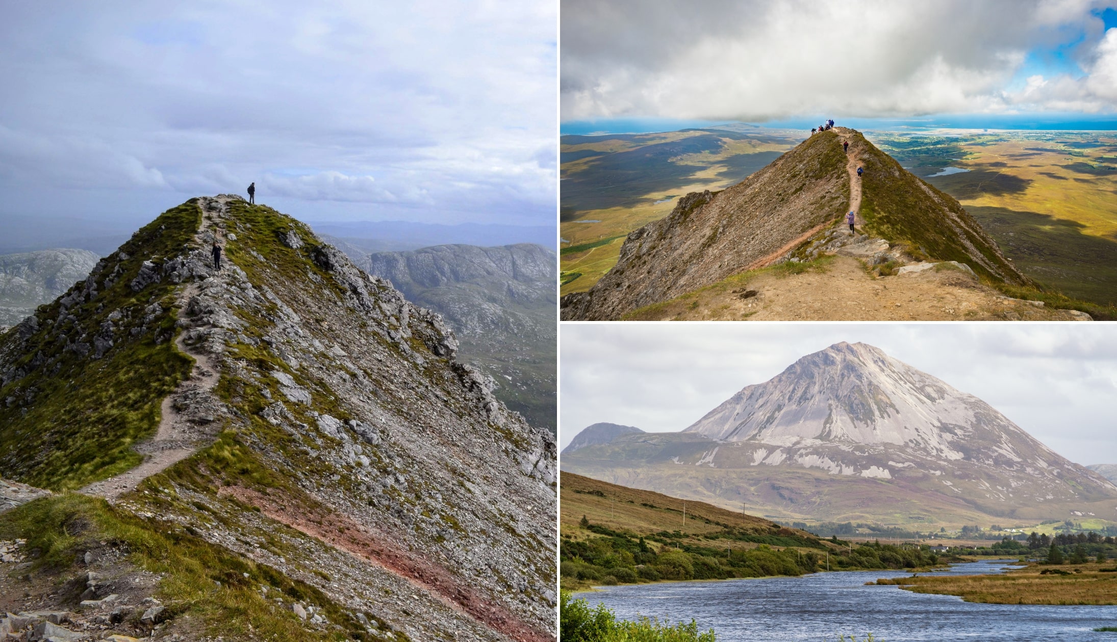
With its dramatic shape and pointed summit Errigal Mountain near Gweedore is, at 2,464 ft (751m) the tallest and steepest of Donegal’s Seven Sisters range
In recent years, incredible work has gone into making climbing Mount Errigal much more enjoyable with the addition of both a path through the boggy section and steps towards the summit.
Some quick need-to-knows about climbing Mount Errigal

Photos via Shutterstock
Although climbing Mount Errigal is fairly straightforward, there are a few need-to-knows that’ll make your visit that bit more enjoyable.
1. Location
The start point for the Mount Errigal walk is a 20-minute drive from Falcarragh, a 25-minute drive from Dungloe and Dunfanaghy and a 35-minute drive from Letterkenny Town.
2. Parking
The Mount Errigal car park is located along the R251 road (here on Google Maps) and it fits around 10 to 12 cars depending on how people have parked. Keep in mind it gets very busy on fine summer days.
3. Length and difficulty
The Errigal Mountain hike is a moderate to strenuous trail that measures around 4.5km in length. It should take between 1.5 – 2 hours depending on 1, pace and 2, how long you spend admiring the view.
4. New path and steps
Outstanding conservation work has taken place in recent years at Errigal. A 1.4km path from the car park now covers a previously very boggy section. The addition of steps towards the summit, similar to the ones installed on Croagh Patrick, were another welcome addition.
About Errigal Mountain


Photos via Shutterstock
If you’re looking for active things to do in Donegal, a morning spent conquering Errigal Mountain really is hard to beat.
At 2,464 ft high, this is the highest peak in the Seven Sisters and it’s the tallest peak in the Derryveagh Mountains.
If you tackle the Mount Errigal hike on a fine day, you’ll have views of everywhere from Slieve Snaght in north Donegal to Sligo’s Ben Bulben.
It’s a welcome sight as you spin around this corner of Donegal, especially at sunset as, thanks to its quartzite composition, it takes on a striking pink hue when the sun starts to drop.
According to legend, Errigal Mountain was named by the Fir Bolg – the forth group of people to settle on the island. The name means ‘oratory’ in Irish.
However, unlike Croagh Patrick, there’s no church to be found around the mountain itself, so it’s believed that the name may refer to the mountain itself being a place for worship.
An overview of the Mount Errigal hike


Now, please note that the map above is intended to give you a rough outline of what the route to the summit is like.
There’s now a clear trail for the first chunk of the walk (this is only a recent addition!).
Beginning the ascent
From the car park, the start of the trail is very clear. This used to be the most painful section as you had to walk through the bog.
You’ll now stroll along around 1.4km of gravel path that helps conserve the bog. Please stick to this path.
The path will eventually become steep and it’s from here that the real challenge begins.
Reaching the summit of Errigal
The trail up Errigal Mountain from this point is easy to follow and there’s now steps in place where you previously had to scramble.
However, it can still be slippy at times so be careful that you don’t lose your footing (I’ve heard a few grisly stories about broken ankles here).
The path continues up and begins to narrow while the hillside drops away on either side of the trail.
The two summits
One unique thing about the summit of Errigal Mountain is that it has two peaks!
While the first one you reach is the tallest, the second one is joined by a narrow path called One Man’s Pass and the crossing is only 30-40 metres.
Please note that there isn’t a whole lot of room at the top and it can get extremely blustery, so please be careful.
On a clear day to the north, you should be able to make out the summit of Slieve Snaght in north Donegal, while looking south, Sligo’s Benbulben may also be visible.
Making your descent
The descent of the Mount Errigal hike will take between 40 minutes and 1 hour.
In years past, this is where I placed a warning, as it used to be dodgy in places on the way down.
However, the new steps and path have made what was always (in my opinion) one of the best hikes in Donegal a whole lot more enjoyable.
Things to do after the Mt Errigal hike
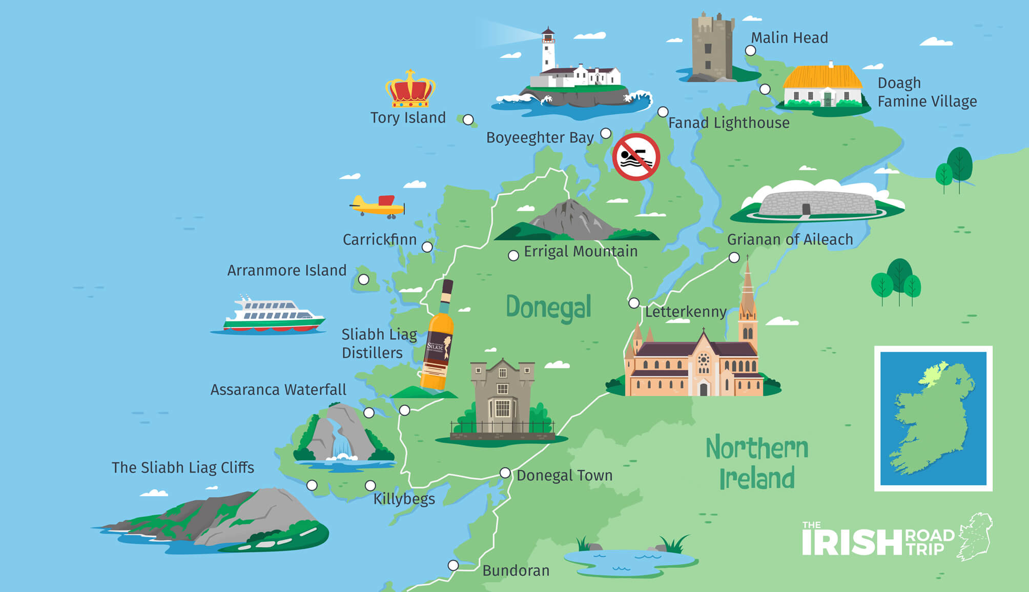

One of the beauties of Errigal Mountain is that it’s a short spin away from many of the best places to visit in Donegal.
Below, you’ll find a handful of things to see and do a stone’s throw from Errigal!
- A post-hike feed (25-minute drive): There are several good restaurants in Dunfanaghy and you can also head for a stroll on Killahoey Beach after
- Glenveagh National Park (10-minute drive): Home to several trails and the ancient Glenveagh Castle
- Carrickfinn Beach (25-minute drive): Arguably one of the best beaches in Donegal, this is well worth a visit.
- Ards Forest Park (25-minute drive): A forest with beaches… yes, beaches!
Keith O’Hara has lived in Ireland for 35 years and has spent most of the last 10 creating what is now The Irish Road Trip guide. Over the years, the website has published thousands of meticulously researched Ireland travel guides, welcoming 30 million+ visitors along the way. In 2022, the Irish Road Trip team published the world’s largest collection of Irish Road Trip itineraries. Keith lives in Dublin with his dog Toby and finds writing in the 3rd person minus craic altogether.