The enormous Croaghaun cliffs are officially the highest sea cliffs in Ireland and they’re one of the most unique places to visit in Mayo.
You’ll find them on Achill Island where they stand at a mind-boggling 2,257 feet/687 meters…
If you fancy visiting them, there are several different routes to take, each of which comes with many different warnings/safety notices.
In the guide below, you’ll find out everything from where to park for the Croaghaun hike to what to expect along the way.
Some quick need-to-knows about the Croaghaun Cliffs: The highest sea cliffs in Ireland
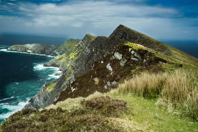

Photo by Junk Culture/shutterstock.com
There are several different Croaghaun hikes that you can head off on, many of which tackle the mountain itself (the SW side).
The guide below takes the most straightforward route to see the Croaghaun sea cliffs (in my opinion), however, you can always alter your route if needed (see warnings below).
1. Location
You’ll find the Croaghaun cliffs hidden away at the western end of Achill Island on the northern side of the towering Croaghaun Mountain, on the other side of the magnificent Keem Bay.
2. Height
The Croaghaun sea cliffs stand at a mind-boggling 2,257 feet/687 meters… yep, that’s pretty damn high. They’re the third highest in Europe after Hornelen in Norway (2,821 feet/860 meters) and Cape Enniberg on the Faroe Islands (2,474 feet/754 meters).
3. How long it takes
The hike to Croaghaun, if you take the route below from near Keem, will take between 1.5 to 2 hours to complete, depending on 1, pace and 2, how long you stop to soak up the views.
4. Difficulty
You’ll need a good level of fitness for the Croaghaun hike, as it’s very steep on the way up. When you reach level ground, it gets much easier. What makes this hike tricky is 1, changing weather conditions (see below) and 2, the lack of a clear trail.
5. Safety warning 1
The Croaghaun hike is one for the more seasoned walkers. It’s steep and a good level of fitness is required. It’s also recommended that you have the ability to use a map and compass – if the weather turns while you’re walking here, things can get very dangerous very quickly.
6. Safety warning 2
It gets insanely windy up at Croaghaun Mountain, so make sure to use caution and ALWAYS stay well away from any cliff edges. It’s worth using the likes of yr.no to get an idea of the weather conditions on the day of your hike. I definitely wouldn’t be doing this one on a very windy day.
An overview of the Croaghaun Mountain hike


Photo by Mike Hardiman/shutterstock.com
I’m going to break down each section of the hike up to see the Croaghaun sea cliffs for you below. Remember, this is a hike for the more seasoned hill walkers and this guide isn’t a substitute for a map and compass.
Keep in mind that there are multiple different starting points and multiple routes you can take on the Croaghaun hike, with some trails taking 4+ hours to complete. Below, you’ll find one of the shorter routes from Keem Beach.
1. Parking


Photo © The Irish Road Trip
Ok, so there are a few different places to park. You can park at the little car park near Corrymore Lake (not far from Keem Bay) or you can park at Keem.
The walk down from Corrymore is nice and scenic and you’ll be treated to gorgeous views out over the bay. There’s a toilet just up from Keem, too, which is handy.
2. Starting off the walk


Photo via Google Maps
When you’ve parked up, you’ll need to make your way up the hill across from the beach. There’s usually a fairly easy to see trail here.
This is a pretty steep hike and, if you visit early in the morning when the grass is wet or after rainfall, it can be very slippy, so be careful – shoes with good grip are recommended.
Keep heading up and eventually you’ll reach level ground. You should start to hear the waves crashing against the cliffs that are situated right in front of you.
3. Head over to the ruins of the old disused coastguard lookout station


Photo via Google Maps
If you look to your left, you’ll see a small building off in the distance (see photo above) – the ruins of an old disused coastguard lookout station.
Make your way over here. It’s a steepish slog, but it’ll be much handier than the ascent from the beach. To your left, you’ll have glorious views of Keem.
To your right, there’s a sheer drop, so please make sure to give it a wide birth! The house is a good place to catch a breather and to soak up some aerial views of Keem Bay and Achill Island.
4. Making your way over to see the Croaghaun sea cliffs


Photo via Google Maps
From Charles Boycott’s house, you’ll have a fairly clear view over to where you need to go to get a good view of the cliffs.
If you go to the Google Map below, we have near enough this point marked down for you. Make your way across and PLEASE keep a good distance from the cliff edge on your left.
It’s a steep climb up to the point where you get the view, but you’ll find space here to admire the view. Just don’t be tempted to get to close to the edge.
5. Getting back down
Photo by Junk Culture/shutterstock.com
After soaking up the view above for a bit, it’s time to make your way back down to wherever you left the car.
Simply (and CAREFULLY!) refollow your steps back down and make sure to be careful, as it can get slippy here.
I know I’ve said ‘be careful’ and ‘stay well away from the edge’ a million times at this stage, but this places really is dangerous if proper care isn’t taken.
A map of the Croaghaun hike
The black markers on the Croaghaun hike map above show the two different places that you can park: Keem and Corrymore Lake.
The purple marker on the right shows roughly where Charles Boycott’s house is. The purple marker on the left is roughly where you’ll get a good view of Ireland’s highest sea cliffs.
Things to do after seeing the Croaghaun Cliffs


Photo © The Irish Road Trip
One of the beauties of the Croaghaun cliffs is that they’re a short spin away from plenty of other places to visit on Achill.
If you hop into our guide to the best things to do on Achill Island, you’ll find more walks, a scenic drive and much more.
If you fancy staying on the island, hop into our guide to the best hotels in Achill. If you can’t find accommodation on the island, the likes of Newport and Westport are solid options, too.
FAQs about visiting the Croaghaun cliffs on Achill
We’ve had a lot of questions over the years asking about everything from are the Croaghaun cliffs really the highest sea cliffs in Ireland to how to reach them
In the section below, we’ve popped in the most FAQs that we’ve received. If you have a question that we haven’t tackled, ask away in the comments section below.
How do you get to the Croaghaun cliffs?
There are multiple ways of getting up to see the highest sea cliffs in Ireland. The most straightforward, in our opinion, is the route from Keem (see above).
What are the highest sea cliffs in Ireland?
The highest sea cliffs in Ireland are the Croaghaun cliffs, however, some travel guides would lead you to believe it’s Slieve League.
Where do you park for the Croaghaun hike?
You can park in multiple places, but the most popular are at Keem and at Corrymore Lake.
Keith O’Hara has lived in Ireland for 35 years and has spent most of the last 10 creating what is now The Irish Road Trip guide. Over the years, the website has published thousands of meticulously researched Ireland travel guides, welcoming 30 million+ visitors along the way. In 2022, the Irish Road Trip team published the world’s largest collection of Irish Road Trip itineraries. Keith lives in Dublin with his dog Toby and finds writing in the 3rd person minus craic altogether.
Kevin Quinn
Tuesday 24th of January 2023
Just to clarify - only the third picture in this post is taken from the 687 meter Croghan Cliffs. The high point you see in most of these pictures is Benmore, which is just over 300 meters high. The high point of the Croghan Cliffs lies to the northeast (right), outside of these pictures. Though the cliffs shown in these pictures are not the high ones, they are probably the most picturesque - and a lot easier to get to than the high point.
Mike Roberts
Sunday 28th of August 2022
I wish I was a few years younger it sounds well worth the effort ,I don't understand why it is not better known .Thanks. Incidentally it should be "wide berth" not "wide birth", sorry for pedantry !
John Sweeney
Tuesday 29th of June 2021
The building you refer to as Captain Boycott's House is in fact an old disused coastguard lookout station. Caption Boycott's House is back towards the lough shown to the east on your map as a parking spot (well the car park is next to the lough to be more accurate - which is the source for mains water on the island). Boycott's House can be seen on the right hand side as you drive towards Keem Bay on the rise after you pass Dooagh.
As a side note when I was a boy first visiting Keem Bay with my father in about the late 1970's (an Achill man) we were told that some years before a German visitor set up camp with his tent up on the Croghaun hill in the lee of the station but tragically his tent was blown away during the night and him with it into the bay. That story gets rolled out for my own family each time we visit. Campers take note!
Keith O'Hara
Tuesday 29th of June 2021
Well, that's awkward! I've told a clatter of people that I've done this walk with that it was Boycott's! Cheers for that John! I'll get it updated now! Much appreciated.
All the best.
Keith
John Smith
Thursday 9th of July 2020
What's the problem? It's just the difference between being on the mainland of Ireland and an off-shore island (albeit connected to the mainland by a bridge, like many other Irish off-shore islands.
What is stange to me is that Croaghaun cliffs are so little known. Touropia's list of the '18 most dramatic sea cliffs in the world' includes Moher and Slieve League but not Croaghaun! I guess it is their inaccessibility as a tourist attraction that causes them to be disregarded.
Mike
Tuesday 28th of December 2021
@John Smith, Hi, I wouldn't say they are difficult to access at all, apart for the fact they are in the extreme tip of the north west. By far my most favourite hike in the Connaught, I wild camp up there regularly and don't want to come down in the mornings
Louise
Wednesday 17th of June 2020
I don’t understand - isn’t Donegal in the Republic of Ireland so therefore IN Ireland too? I know I’m missing something about the statement but it’s driving me crazy trying to work out what! Thanks in advance!
Keith O'Hara
Wednesday 17th of June 2020
Hey Louise. So, Donegal is on the mainland - so onIreland. Achill Island, although connected to the mainland by a bridge, is separate to Ireland. So, Slieve League is the highest on the island of Ireland while Croaghaun are the highest in Ireland.
Haha! I'm confusing myself here now. Hopefully the above makes sense!