
If you are looking to conquer Divis and Black Mountain in Belfast, this guide contains a map and a trail overview for each hike.
Divis stands at an impressive 1,568 ft (478 m) while Black Mountain comes in at 1,275 ft (389 m) and each present a challenge to those looking to climb them!
I’m going to give you a map and overview of the two main trails:
- Option 1: The Divis Mountain Walk (3 miles/4.8km)
- Option 2: The Divis and Black Mountain Walk (4.2 miles/6.7km)
Quick need-to-knows about Divis and Black Mountain in Belfast
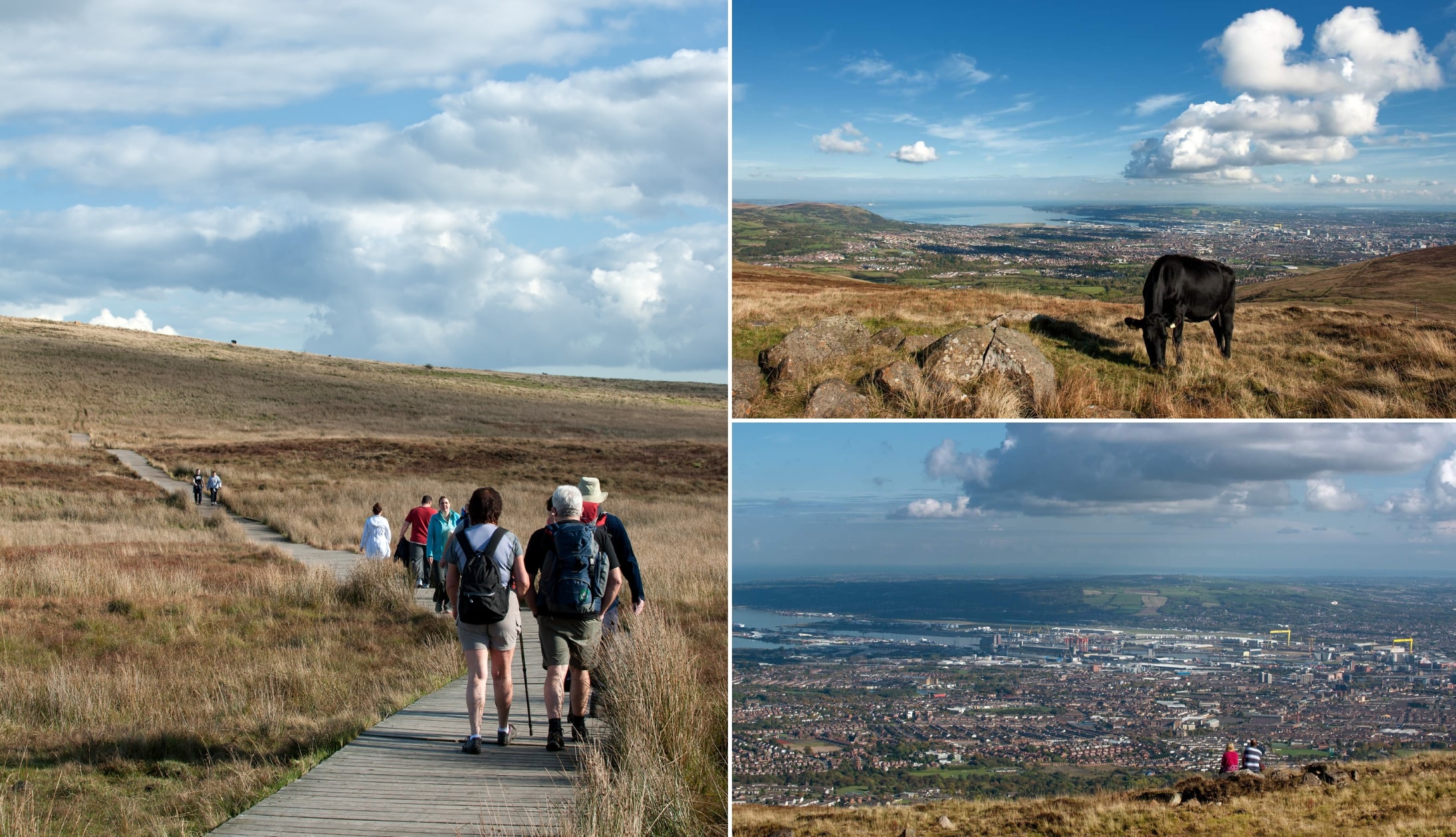
Photos by Arthur Ward via Tourism Ireland
Although the Divis and Black Mountain Walks are much more doable than the nearby Cave Hill Walk, there are some need-to-knows:
1. Location
Divis is just 6 miles/9.7km northwest of Belfast City Centre. It’ll take you around 20 minutes to drive and 25 minutes to cycle. There used to be a shuttle bus operating from the city, but it appears to no longer be running.
2. Car park
The Divis Mountain car park can be found here, just before you reach the Divis Barn Cafe near the trailhead. Please note that, as this is one of the more popular walks in Belfast, the car park can fill up on fine days.
3. The two trails
There are two main trails for tackling Divis Mountain in Belfast and both have incredible views:
- Divis Mountain Walk (aka the Summit Trail): A looped, 3 miles/4.8km trail that takes 1 – 1.5 hours
- Black Mountain Hike (aka the Ridge Trail): A looped, 4.2 miles/6.7km trail that takes 2.5 – 3 hours
4. Coffee, dogs and toilets
You’ll find two toilets in the Barn Cafe along with plenty of options for hot and cold drinks and snacks. You can take your pooch, too, once they’re kept leashed at all times.
About Divis Mountain and Black Mountain

Photo by Art Ward via Tourism Ireland
Presiding over the capital, Divis is the highest peak in the Belfast Hills. With an elevation of 478m, it is an area of moorland.
The word “Divis” is derived from the Irish Dubhais, meaning “black ridge”. Southeast of Divis summit is the 389 m Black Mountain.
Both mountains have stupendous views that take in Belfast City, Strangford Lough, the Mourne Mountains and the uplands of Scotland and Wales on a clear day.
Once controlled by the Ministry of Defense, these mountains are now managed by the National Trust and are still used for Army training.
The Divis Mountain Walk
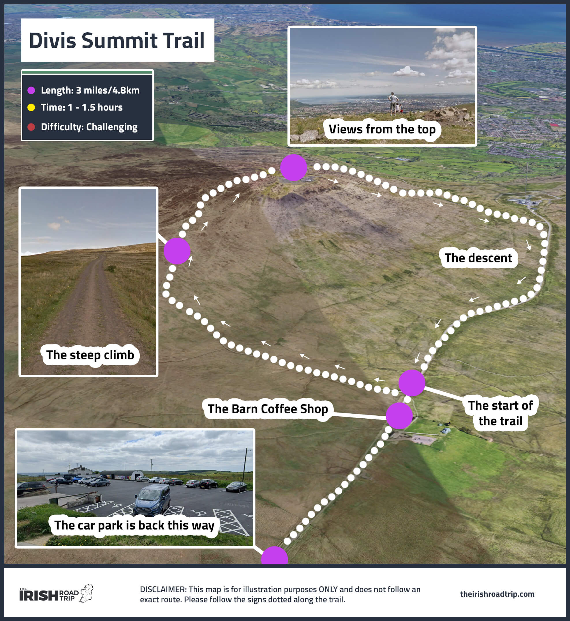
More commonly referred to as the Summit trail, this is a looped, 3 miles/4.8km trail that takes between 1 and 1.5 hours.
Graded as strenuous, you’ll need good fitness and a sturdy pair of walking boots.
Where it starts
This trail begins from the car park near the Barn Coffee Shop on Tipperary Road.
Pass the pond on your right, go through the kissing gate and follow the way-markers across heathland with areas of blanket bog (stick to the trail!).
Getting into the belly of the walk
Take the right fork and further on make a short detour to the viewing point. The views are breathtaking with many places of interest visible on a clear day.
Now the ascent really starts with areas of stone pitching.
These slabs of stone help preserve the mountain slopes from erosion by heavy footfall and running water.
Views and the descent
You’ll see Slemish Mountain in the distance as you climb. The trigonometry pillar marks the summit at 1562 feet/475m.
You made it! Descend by keeping left of the mast and heading down a paved roadway with views of Belfast Lough and the Copeland Islands.
You can see the giant yellow cranes (Samson and Goliath) in the Titanic Quarter of the city. At the bottom of the hill turn right and return to the barn.
The Divis and Black Mountain Walk

The walk in the map above is known as the Ridge Trail. This is a looped, 4.2 mile/6.7km trail that takes 2.5 – 3 hours to finish.
As was the case with the previous trail, this is a strenuous hike that requires good fitness levels.
Where it starts
The Ridge Trail also starts from the Divis Mountain car park. Aim for the coffee shop and then pass through the kissing gate.
You’ll see the start of the trail on your left and that’s where the long, steep slog begins.
Getting into the belly of the walk
Keep going all the way up Divis until you reach the summit. Catch a breather and then start to make your descent towards the summit of Black Mountain.
You’ll pass the Bobby Stone on your right before reaching the trigonometry point at the summit of Black Mountain.
Views and the descent
On a clear day, you’ll be able to make out the Mournes on your right, Slieve Gullion and the outline of the Causeway Coast.
When you’re ready, follow the very well trodden trail back down towards the car park.
Things to do nearby
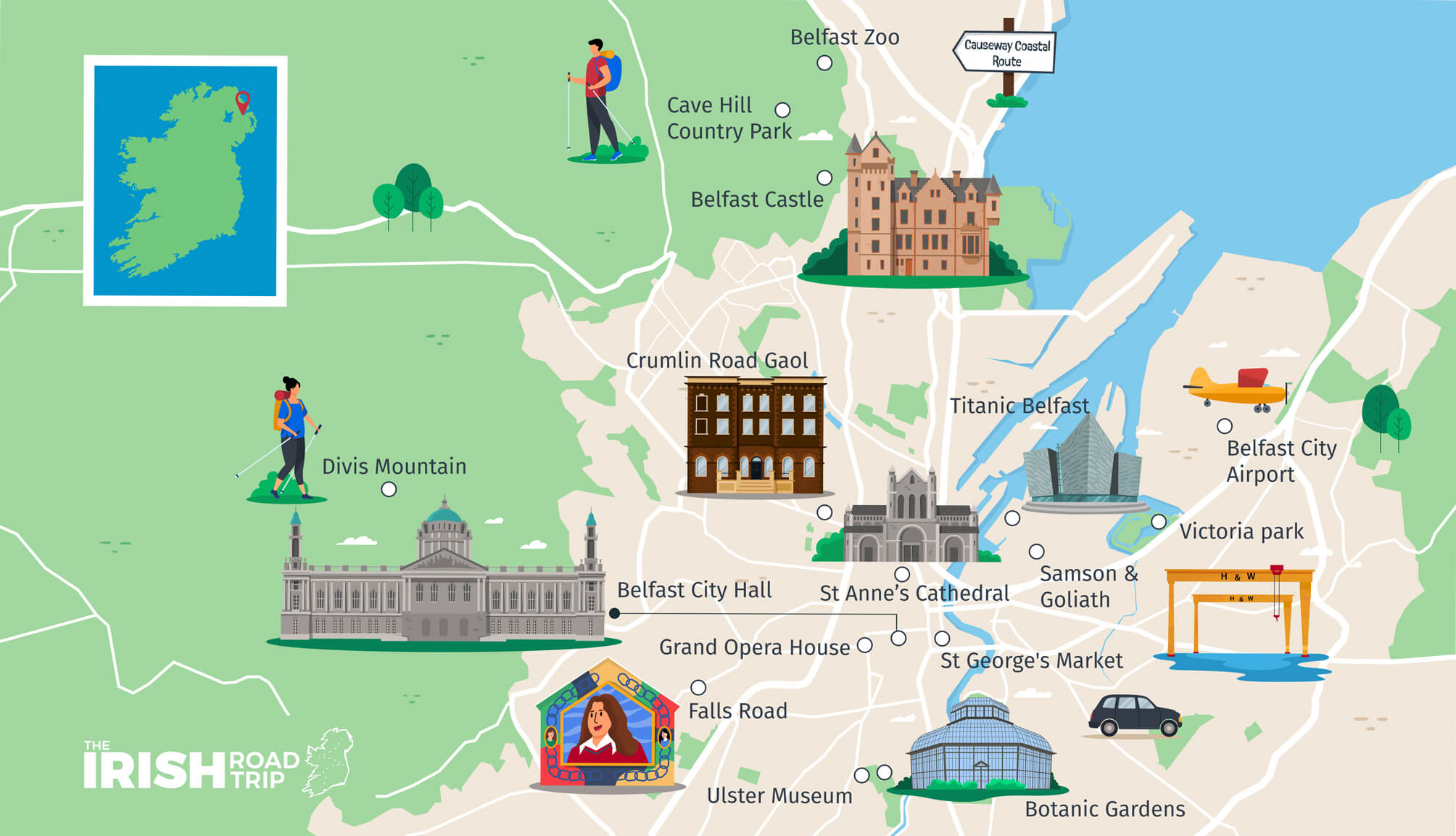
One of the beauties of the Black Mountain Walk is that it’s a short spin away from many of the best places to visit in Belfast.
Below, you’ll find a handful of things to see and do a stone’s throw from Divis:
- Post-walk food: There plenty of great restaurants in Belfast. Hop into our Belfast Breakfast, Belfast Brunch or Belfast cafes guides
- Key attractions: The Botanic Gardens, Belfast Castle, the Cathedral Quarter, the Black Cab Tours and Belfast Zoo
Keith O’Hara has lived in Ireland for 35 years and has spent much of the last 13 creating what is now The Irish Road Trip guide. Over the years, the website has published thousands of meticulously researched Ireland travel guides, welcoming 40 million+ visitors along the way. In 2022, the Irish Road Trip team published the world’s largest collection of Irish Road Trip itineraries. Keith lives in Dublin with his dog Toby and finds writing in the 3rd person minus craic altogether.