
Carved through the mountains in 1847 as part of a Famine relief project, Healy Pass is a twisty, 12km road that passes from Cork into Kerry, delivering some of Ireland’s wildest, most isolated scenery.
Often described as one of Ireland’s most unique drives, this is a mountain pass that reaches an elevation of 334 metres.
The route starts at the Adrigole Bridge in Cork and proceeds to the Lauragh Bridge in Kerry and you can explore it, and the area around it, on the Ring of Beara drive.
About Healy Pass in Cork

Although a visit to Healy Pass in Cork is fairly straightforward, there are a few need-to-knows that’ll make your visit that bit more enjoyable.
1. Location
The Healy Pass is located in the Beara Peninsula, in the Caha mountain range, in south west Ireland. It straddles the West Cork and Kerry border and although most of it lies in Cork, a section is in Kerry.
2. Famine relief
The Healy Pass was created in 1847. Built during the Great Famine, the road was put in place to prevent starvation and was later named after Timothy Healy, who was the first governor general of the Irish Free State.
3. Safety
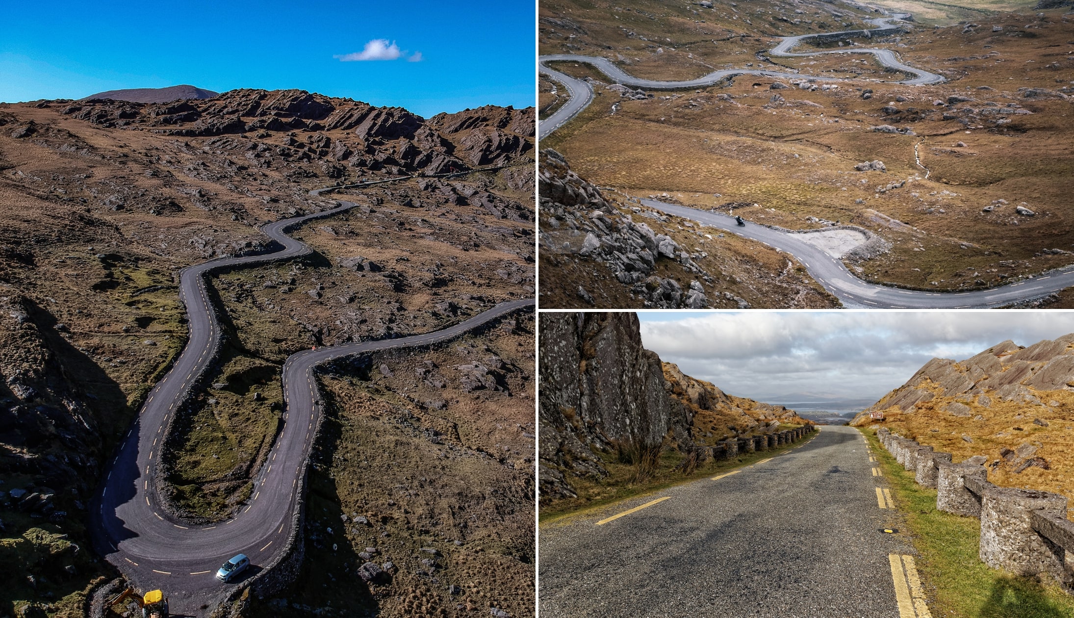
The road is extremely bendy, twisting and turning through mountainous terrain. While the Healy Pass is perfectly safe, drivers need to be on the lookout for walkers and cyclists who also love the challenge the route presents.
The History of Healy Pass

Photos by the Irish Road Trip
The original Healy Pass was called ‘the Kerry Pass’ and it was cut through the mountains during the famine years as a poor relief public works project.
It is one of many ‘Famine roads’ that can be found dotted around Ireland. The building of Famine roads began during Robert Peel’s Conservative Government’s initiatives to improve Ireland’s infrastructure.
Aside from this, they also strengthen Ireland’s economy and provided employment to the many that were devastated by the failure of the potato crop during 1845.
Unfortunately, this scheme was hit by problem after problem. It was badly managed, there was a shortage of appropriate tools and the workers suffered due to malnutrition.
The wages were poor and there were regularly delayed payments being made, which resulted in the scheme being abandoned.
The previously named ‘Kerry Pass’ was improved and renamed the Healy Pass in honour of former governor general of the Irish Free State, Timothy Michael Healy.
The Healy Pass drive/cycle route
Photos via Shutterstock
In my opinion, having visited Healy Pass many times over the years, the best way to approach it is from the Cork side.
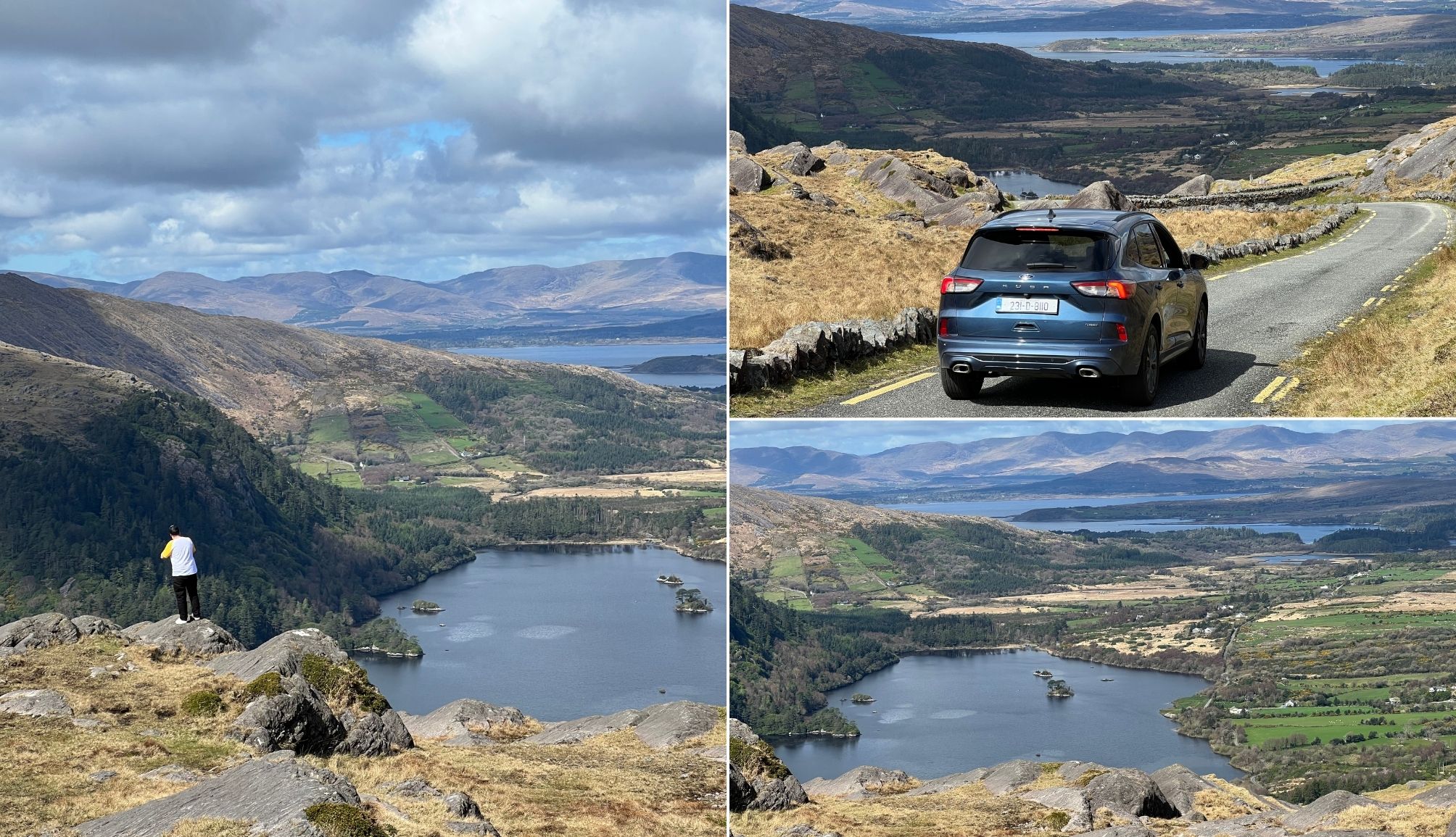
The reason for this is you get to drive/cycle towards Glanmore Lake once you reach the top – this is scenery like no other!
If you follow the Ring of Beara route, you’ll visit the Pass in a logical manner that takes in the areas other attractions (you can start from Kenmare or Glengarriff).
The main viewpoints at the pass are:
- This one: Note that there is only space for one car and care is needed
- This one: There is more space to pull in here at the top
Don’t miss the Glanmore Lake viewpoint
Photos by the Irish Road Trip
If you continue up the hill towards the highest point of the Healy Pass (on the County Cork side), you will find some space to pull in and park (here on Maps).
There isn’t a lot of room here, and the pull in area sits at the top of a hill, so it’s extremely important to ensure that you never leave your vehicle out on the road.
Next to this spot, there is a hill that is easy enough to walk up (although be careful when it is wet).
On the Cork side, you’ll be able to see the whole Healy Pass, while on the other side you will get incredible views of Glanmore Lake and beyond.
Things to see nearby

The Pass is a short drive from many of the best places to visit in Cork. Follow the route in the map above and you’ll explore:
- The Beara Peninsula: Backed by the Miskish and Caha mountains, the Beara Peninsula is a rugged, unspoiled stretch of coast with walks, beaches, historical sites and glorious scenery
- Bere Island: Just a short ferry from Beara, Bere Island is rich in archaeological sites, from Bronze Age tombs to medieval ring forts and standing stones
- Dursey Island: Hop on Ireland’s only cable car to Dursey Island, where you’ll find peaceful walking trails and stunning ocean views
- Gleninchaquin Park: Located in a scenic valley on Beara, Gleninchaquin Park offers mountain paths, lakes and waterfalls
Keith O’Hara has lived in Ireland for 35 years and has spent much of the last 13 creating what is now The Irish Road Trip guide. Over the years, the website has published thousands of meticulously researched Ireland travel guides, welcoming 40 million+ visitors along the way. In 2022, the Irish Road Trip team published the world’s largest collection of Irish Road Trip itineraries. Keith lives in Dublin with his dog Toby and finds writing in the 3rd person minus craic altogether.