
There’s some excellent short walks in Wexford, but if you fancy more of a challenge then get yourself to Forth Mountain!
And while this isn’t the largest of mountains, these are several long, demanding trails with tons of interesting history along the way to tackle.
In the guide below, you’ll find info on everything for parking and the walks to the stunning Forth Mountain Quarry.
Some quick need-to-knows about Forth Mountain
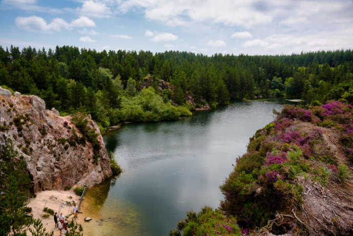
Photo © Fáilte Ireland courtesy Luke Myers/Ireland’s Content Pool
Although a visit to Forth Mountain in County Wexford is fairly straightforward, there are a few need-to-knows that’ll make your visit that bit more enjoyable.
1. Location
You’ll find Forth Mountain a handy 15-minute drive from Wexford Town, a 25-minute drive from both Rosslare and Kilmore Quay and a 40-minute drive from the Hook Peninsula.
2. Height
Not a mountain in the true sense of the word, Forth Mountain is more of a long low quartzite ridge. It does reach a height of 780 feet, meaning it’s no slouch, but it isn’t particularly conical in the way that you’d imagine the classic mountain shape. That doesn’t mean it can’t pose a challenge, however!
3. Two main trails
There are two main trails that we’re going to look at in this post – the Loop Walk and the Three Rocks Trail. Both are at least 10km long so you’re going to need some preparation (more on that shortly). They’ll also take between 2 and 4 hours, so try to dedicate the day to tackling them!
4. Parking
There are several different Forth Mountain car parks. For the looped walk, park at the New Line Car Park (here on Google Maps). For the Three Rocks Trail, park in either the New Line Car Park or this one over in Ferrycarrig.
5. Preparation needed
As I mentioned earlier, these are long old hikes so it’s worth preparing in advance what you might need. Definitely check the weather and always bring weather-appropriate boots and clothing. Make sure your phone is fully charged and you bring plenty of snacks and water too!
6. A trail steeped in history
It was here in 1798 that the Battle of Three Rocks took place – a United Irish victory during the Wexford Rebellion, a part of the 1798 Rebellion, against a British artillery column marching to reinforce Wexford town against anticipated rebel attack. Among many other things, this event is marked during the Three Rocks Trail.
An overview of the Forth Mountain Loop Walk

Map with thanks to Coillte
- Difficulty: Moderate
- Length: 10km
- Time: 2 hours 30 minutes
- Format: Loop
- Waymarkers: Red
Start
Park up at the New Line car park just off the R733 and kick off your walk by heading onto the trail and following the red waymarks.
The initial stretch of the trail will take you past Carrigatinna Rock on your right-hand side, an imposing Cambrian quartzite mound (one of many!). Follow the trail to the right and head into the grassy Shelmaliere Commons where you’ll eventually end up at Skeator Rock.
Make sure you stop here to take in sweeping panoramic views of the Wexford coastline including Rosslare, Our Lady’s Island, Saltee Islands, Hook Head Lighthouse and across into Dunmore East and the Waterford estuary.
Mid-section
Follow the red waymarks north up into the Pennylands area of Forth Mountain. Here you’ll get some more great viewing opportunities and the best stops to take advantage of these include the Grotto and another one near Clourane.
Follow the loop around into the Tincurra Trails. This is where the trail evens out a little to a gentler gradient (your legs will be thankful!). You’ll also have switched to the northern side of the mountain by now meaning you’ll get some cracking views of the Barntown, the Blackstairs Mountains and the west of the county.
Finish
Continue along the loop and follow the red waymarks back down south through Pennylands and down towards the Shelmaliere Commons and finally the car park.
An overview of the Three Rocks Trail
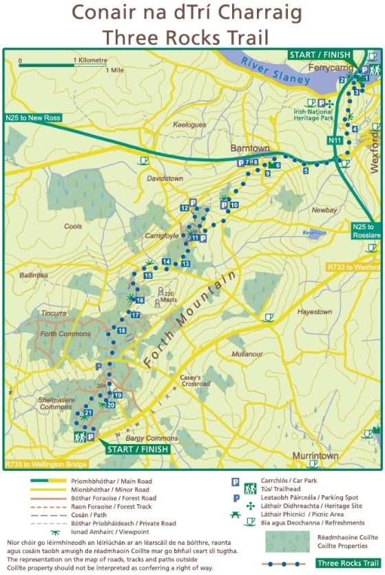
Map with thanks to Coillte
- Difficulty: Moderate
- Length: 13km
- Time: 4 hours
- Format: Linear
- Waymarkers: Blue
Keep in mind
One of the reasons we tend to recommend the looped walk is due to the Three Rocks Trail being linear – you’ll either need to arrange for someone to collect you for the finish point, which is a pain.
Start
The Three Rocks Trail leads you along part of the route traversed by the Wexfordmen during the 1798 rebellion (there’s a number of famous sites – I’ll try to cover the main ones!), so kick off your hike at the 16th century Ferrycarrig Castle and Bridge.
This time you’ll be following the blue waymarks so follow the arrows through the lost town of Carrig before you eventually come to the 16th century Barntown Castle (built by the Roche family, who also built Ferrycarrig Castle).
Mid-section
Continue south onto the mountain where the next important site you’ll come across is the Three Rocks 1798 Campsite, a rebel base used to launch an attack on crown forces on the 30th May 1798.
Carry on until you reach Carrigfoyle Rock, a stunning viewpoint with 360-degree views of the surrounding landscape. By the time you reach the Raven Rock (where the three baronies of Forth, Bargy and Shelmalier meet), you’ll be at the heart of Forth Mountain and near to the Loop Trail.
Finish
One of the more unique points of interest as you head towards the finish is Jim Furlong’s House, a typical ‘Forth Mountain House’ with two rooms and built of stone. Follow the waymarks down south through Pennylands and down towards the Shelmaliere Commons, past Carrigatinna Rock and finally to the car park.
Things to do near Forth Mountain
One of the beauties of the Forth Mountain walk is that is that it’s a short spin away from many of the best places to visit in Wexford.
Below, you’ll find a handful of things to see and do a stone’s throw from Forth Mountain (plus places to eat and where to grab a post-adventure pint!).
1. Post-hike food in Wexford Town (10-minute drive)

Photos via Simon Lambert & Sons on FB
Wexford is the nearest town to Forth Mountain and there’s loads of choice waiting for you if you want to grab something to eat after your hike. If you hop into our Wexford restaurants guide, you’ll find heaps of places to try, like the brilliant Lambert and Sons pictured above.
2. Irish National Heritage Park (10-minute drive)

Photos by Chris Hill via Ireland’s Content Pool
12 minutes from Forth Mountain and just 10 minutes from Wexford, Irish National Heritage Park tells the story of human settlement in Ireland from the Mesolithic period right up to the Norman Invasion in 1169. The park features reconstructions of historic sites and visitors can walk in and explore traditional homes, villages, monuments, and buildings.
3. Johnstown Castle (10-minute drive)
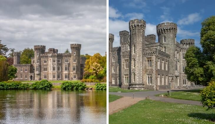
Photos via Shutterstock
Johnstown Castle is indeed a castle, but it’s so much more than that! With the Irish Agricultural Museum, Gardens, Lake Walks & Playground also a part of the Johnstown Castle experience, there’s loads to discover that goes far beyond its already fascinating 800-year history. And at just a 10-minute drive from Forth Mountain, it’s really easy to reach too.
FAQs about the Forth Mountain hike
We’ve had a lot of questions over the years asking about everything from ‘How long does it take?’ (2.5 – 4 hours) to ‘Is it tough?’ (yes).
In the section below, we’ve popped in the most FAQs that we’ve received. If you have a question that we haven’t tackled, ask away in the comments section below.
Is the Forth Mountain walk tough?
The two trails we detail above are both of moderate difficulty and a bit of preparation is required in advance of the walk.
Where do you park for the Forth Mountain hike?
If you do the Forth Mountain Loop, park in the New Line Car Park (linked above). For Three Rocks, you’ve your choice of two (see link to Google Map above).
Tom Mc kenna
Saturday 26th of March 2022
Great information about the trails @ surrounding area. Well explained. Can't wait to get the time to do them.Thanks a lot.