
This Sheep’s Head and Mizen itinerary is a roughly 146km/91 mile road trip route that’s best tackled over the course of 2 days.
You could do it in 1 (the total drive time is just under 3 hours), but it would be a very rushed day and you’d have to skip some stops.
Below, you’ll find a map, the different stops and what to look out for along the way. Enjoy!
An overview of the Mizen and Sheep’s Head road trip

There’s a few key chunks of info that you need to be aware of before setting off on this road trip.
You don’t have to follow the map to a tee
I have you starting this road trip in Bantry and finishing in Ballydehob – this won’t suit everyone. You can start and end in Bantry, Schull or wherever – adjust it to suit your starting point!
Route length/time needed
If you do start and finish in Bantry, you’re looking at:
- Distance covered: 146km/91 miles
- Total drive time: 3 hours
Where to stay
Bantry makes a good base for this road trip for a couple of reasons:
- One: You can do this route with ease over 2 days (day 1 = Bantry and Sheep’s Head) and day 2 = Mizen)
- Two: If you have an additional day, you can easily tackle the nearby Ring of Beara route
- Three: Bantry has a huge range of accommodation with something to suit most budgets (see them here)
The itinerary
Photos via Shutterstock
Now that we have the need-to-knows out of the way, it’s time to dive on in. Feel free to leave out stops as you see fit.
Some, e.g. Dunlough Castle, won’t be possible for those with limited fitness, so chop and change to suit your own circumstances!
Stop 1: Bantry House and Gardens

Perched above Bantry Bay with a view that stops you in your tracks, Bantry House and Gardens, one of Ireland’s finest stately homes, is stop one!
Built in 1710, the house is open to visitors, with grand rooms, art collected from around the world, and guidebooks to bring its history to life.
Outside, you’ve seven terraced gardens, woodland walks, and the famous 100 steps with glorious views across the bay. The tearoom in the west wing is perfect for a post-walk bite.
Stop 2: Fionn mac Cumhaill’s Seat

Photos via Google Street View
Leave Bantry Town and follow the coast road west, where the landscape quickly opens up to sea and sky. In just 25 minutes, you’ll reach the next stop – Fionn mac Cumhaill’s Seat (here on Maps)!
Fionn mac Cumhaill’s Seat is a Wild Atlantic Way Discovery Point with a handy pull-in spot overlooking Kilcrohane, Bantry Bay and the distant Beara Peninsula.
The stone bench sits on Seefin, the highest peak on the Sheep’s Head Peninsula, and was unveiled in 1996 to mark the launch of the Sheep’s Head Way walking route
It was carved by Cork sculptor Ken Thompson and bears a line from Seamus Heaney that speaks to the drama of the landscape. The name comes from Irish folklore – Fionn mac Cumhaill is said to have sat here, legs stretched to the lake below.
Stop 3: Sheep’s Head Lighthouse

Follow the road for 20 minutes and you’ll eventually arrive at the car park for the the Sheep’s Head Lighthouse, a small white cylindrical tower built in 1968 to aid tankers heading for the Gulf Oil terminal on Whiddy Island.
It stands 7 metres tall, with its light positioned 83 metres above sea level, and emits three flashes every 15 seconds.
The lighthouse is fully automated and unstaffed, with power supplied by a line of ESB poles. Materials for the build were airlifted by helicopter in 250 trips.
The walk from the car park to the lighthouse takes around 30/35 minutes each way – please take note of the warnings on the map above!
Stop 4: Dunmanus Bay views

Photos licensed via Shutterstock
As you follow the road along the eastern side of the Sheep’s Head Peninsula, you’ll be treated to wide-open views across Dunmanus Bay and over to the hills and headlands of the Mizen Peninsula.
It’s a quiet, winding stretch with the road often hugging the hillside, giving you glimpses of stone walls, scattered farms, and the vast, blue sweep of sea below.
On a clear day, the views stretch all the way to Mount Gabriel and beyond. There’s no stop here – just soak up the scenery as you spin!
Stop 5: Dooneen Pier

Photo left: Google Maps. Right: Shutterstock
Dooneen Pier is around a 15-minute drive from the Sheep’s Head Lighthouse car park. It juts out into Dunmanus Bay with quiet confidence and it acts as a reminder of the peninsula’s deep maritime past.
Built in the 1800s, it was once a key drop-off point for coal and salt, brought in to support the local fishing trade.
You can still spot the old storehouse nearby, along with a concrete magazine! It’s a peaceful spot these days, often missed by passing visitors, but well worth a quick stop to soak up the views and the sense of history clinging to the stonework.
Stop 6: Dunlough Fort

The 1-hour drive from Dooneen Pier to Dunlough Castle takes you through the untamed spine of the Mizen Peninsula, where narrow roads climb steadily through open hillside, bog, and scattered stone walls.
You’ll pass quiet fields and distant views of the Atlantic before reaching a small car park near the trailhead. There’s an honesty box so you’ll need cash (€3 per person).
Dunlough Fort, also known as the Three Castles, was built in 1207 by Donagh O’Mahony. Set on a narrow strip of land between sheer cliffs and a mountain lake, it was designed for defence and isolation.
The three stone towers are connected by a now-crumbled wall that once ran from the edge of the lake to the cliff’s edge. The O’Mahonys held it for over 400 years before it was seized by the Crown in the seventeenth century.
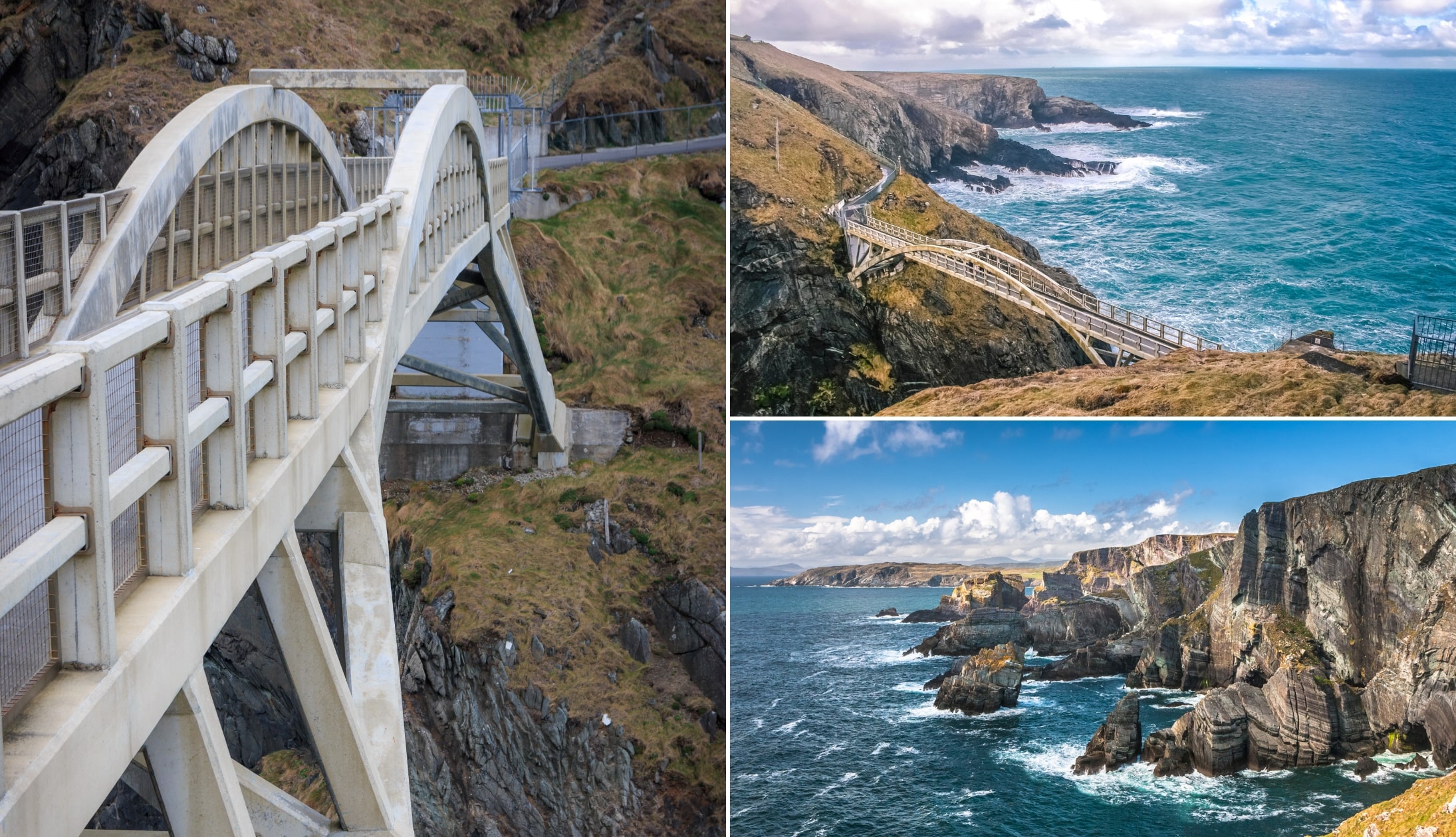
Stop 7: Mizen Head

Mizen Head is a 10-minute drive from Dunlough Castle. It marks one of the most dramatic stretches of coastline in Ireland, with a signal station that’s been guiding ships since the early 1900s.
The visitor centre tells the story of wrecks like the SS Stephen Whitney, which sank in 1847 and led to the building of Fastnet Lighthouse.
You’ll also hear about the 1908 rescue of 63 sailors from the SS Trada, and the fog signals introduced in 1909.
The bridge, originally built in 1910, leads to cliffs that tower above the Atlantic, where seals, dolphins and shipwreck stories linger.
Stop 8: Barleycove Beach
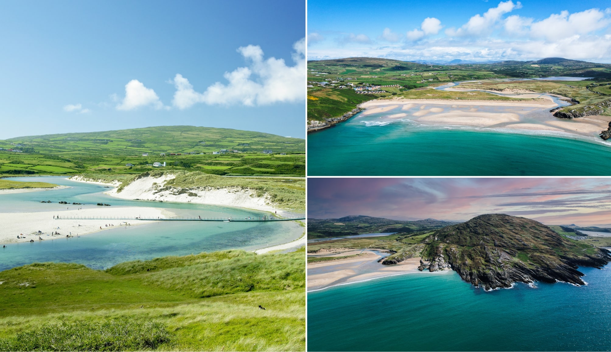
Photos via Shutterstock
Barleycove Beach is a striking stretch of sand a 5-minute drive from Mizen, tucked between two headlands and backed by rolling dunes.
It was formed by a tsunami triggered by the Lisbon Earthquake in 1755, which sent massive waves crashing into this quiet corner of Cork.
Today, it’s one of West Cork’s best beaches, with soft sand and views that stretch all the way to Brow Head.
The beach sits in a Special Area of Conservation and is flanked by walks, wildlife, and one of the finest seafood lunches you’ll find on the coast (at the beach hotel).
Stop 9: Brow Head

Brow Head is 10 minutes from Barleycove and it’s the true southernmost point of Ireland’s mainland and one of the wildest spots in West Cork.
Once a hub of copper mining and British military lookout posts, it’s now a rugged, wind-battered headland with panoramic views across to Mizen, Cape Clear and the open Atlantic.
The 1804 signal tower still stands watch over the cliffs, and ruins of miner’s cottages dot the slopes. You can drive or walk to the top, but the road is narrow and steep. It’s remote, exposed and often empty, and that’s exactly what makes it so special.
Stop 10: Altar Wedge Tomb
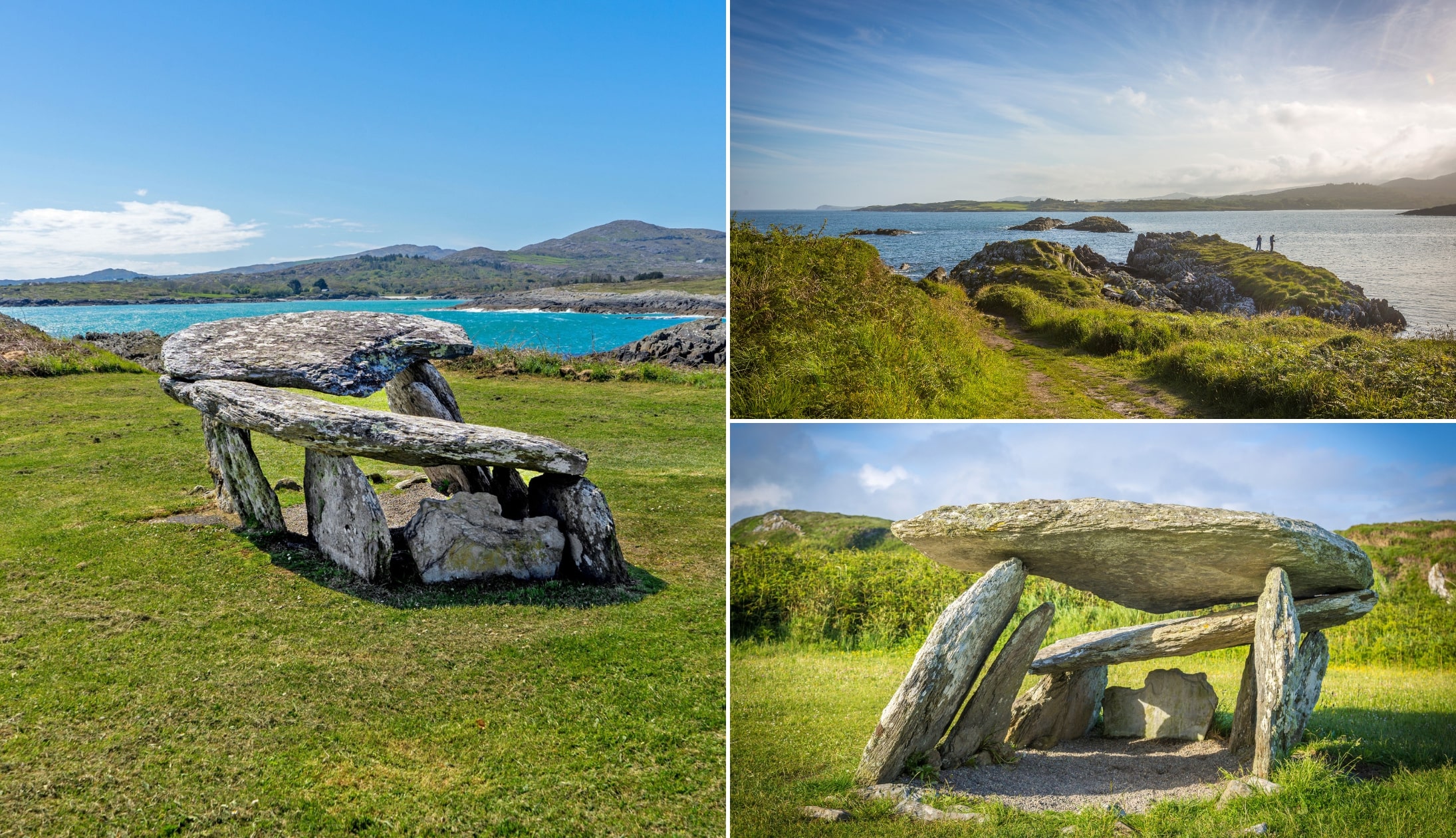
Photos via Shutterstock
One of the final stops on this road trip is Altar Wedge Tomb, a 20-minute drive from Brow Head. You’ll find it tucked away near the edge of Toormore Bay.
This is one of the oldest man-made structures in West Cork. Built over 4,000 years ago, it’s a classic wedge tomb from the late Stone Age, shaped like a narrowing tunnel of upright stones.
It once held cremated remains, animal bones and tools, and was likely used in rituals that changed over the centuries. Later, it became a Mass site during the Penal Laws.
The entrance points towards Mizen Peak, and it may have been aligned with the Samhain sunset.
Stop 11: Schull
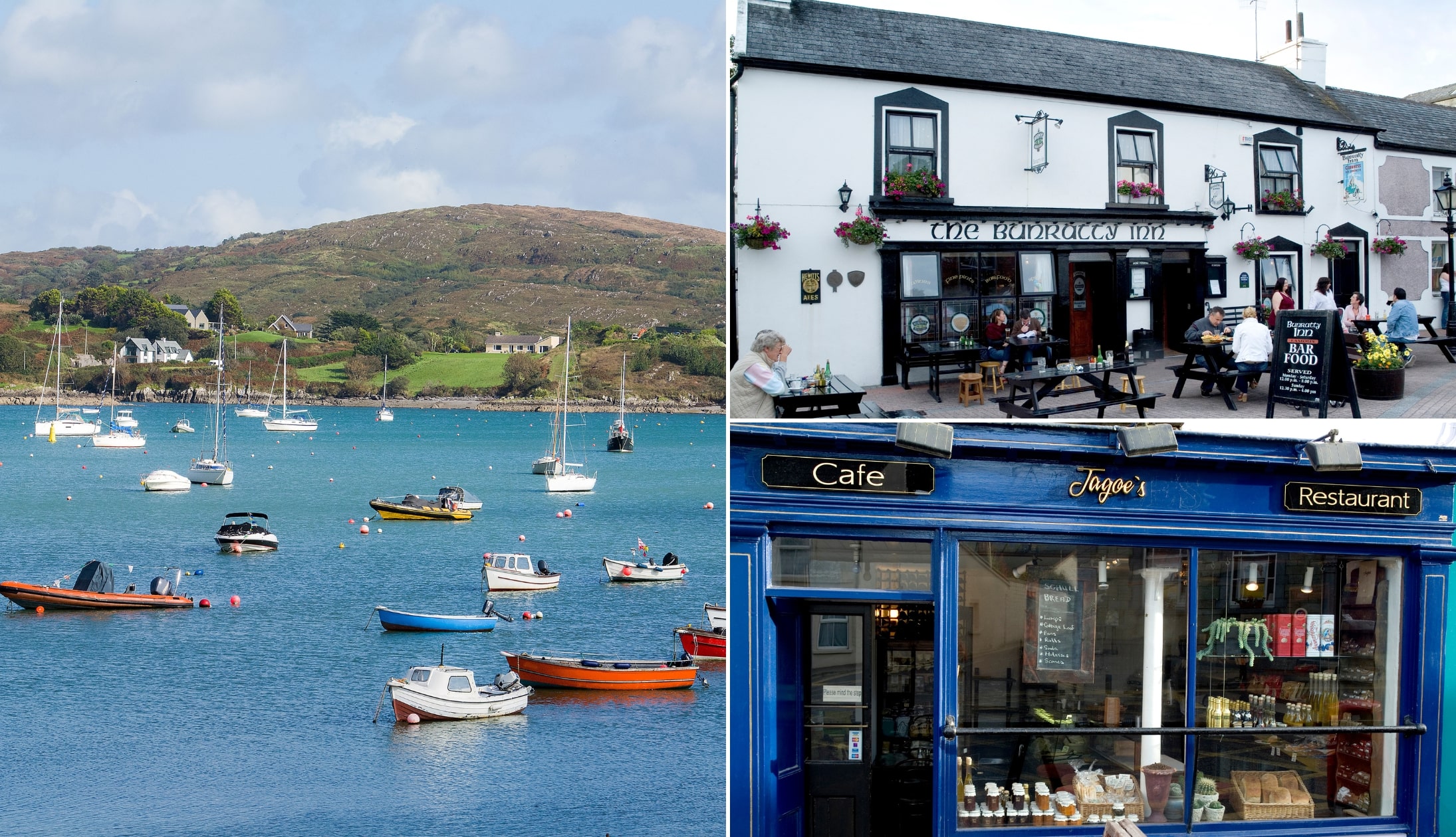
Photo left: Shutterstock. Others: Chrish Hill via Failte Ireland
Continue on to Schull, next, a 7-minute drive away. This is a relaxed harbour village tucked beneath Mount Gabriel on the Mizen Peninsula. It may be small, but it’s surrounded by some of the most striking scenery in West Cork.
The harbour is filled with boats and the town has a strong reputation for sailing, fresh seafood and stargazing, thanks to its community planetarium.
You can hike up Mount Gabriel for panoramic views, hop on a ferry to Cape Clear, or simply saunter around. With lively pubs, good restaurants and plenty of charm, it’s a great place to spend a few days.
Stop 12: Ballydehob
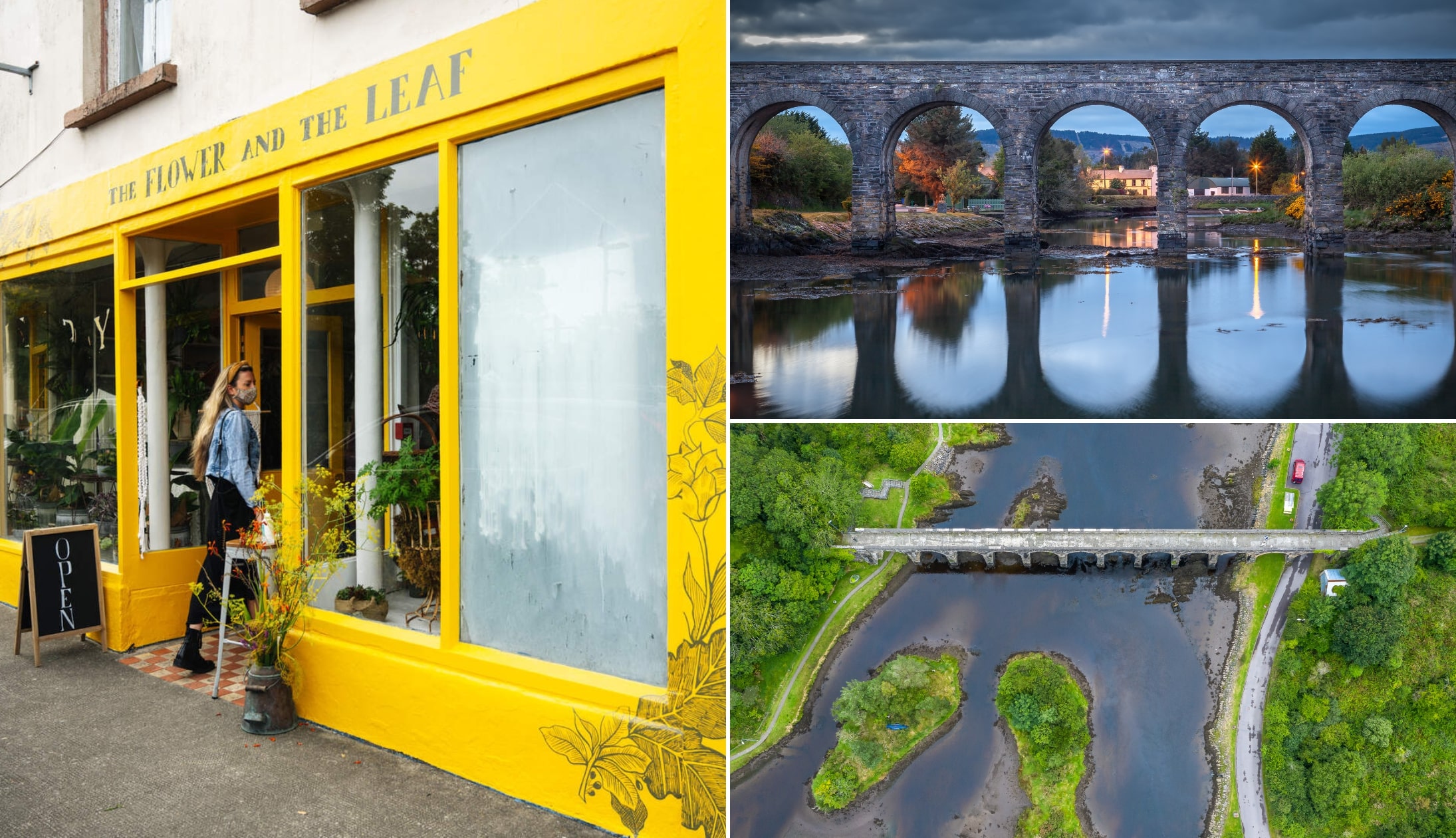
Photo left via Tourism Ireland. Others: Shutterstock
Ballydehob is a quirky little village a 10-minute drive from Schull, and it punches well above its weight when it comes to character. It has a rich backstory shaped by copper mining, famine, and a wave of bohemian artists who settled here in the 1960s.
Today, it’s a lively place with a creative streak, known for its colourful buildings, thriving arts scene, and a packed festival calendar, from jazz and folk to vintage threshing weekends.
The old 12-arch railway bridge still spans the estuary, a reminder of when trains rolled through. It’s a brilliant stop on the Mizen loop.
An optional day on the Beara Peninsula

Depending on how much time you have, you can bring your trip to an end or you can add in a day on the Ring of Beara.
For the unfamiliar, the Ring of Beara is a 148km/92 mile scenic route that showcases some of the best of Ireland’s rugged scenery!
Keith O’Hara has lived in Ireland for 35 years and has spent much of the last 13 creating what is now The Irish Road Trip guide. Over the years, the website has published thousands of meticulously researched Ireland travel guides, welcoming 40 million+ visitors along the way. In 2022, the Irish Road Trip team published the world’s largest collection of Irish Road Trip itineraries. Keith lives in Dublin with his dog Toby and finds writing in the 3rd person minus craic altogether.