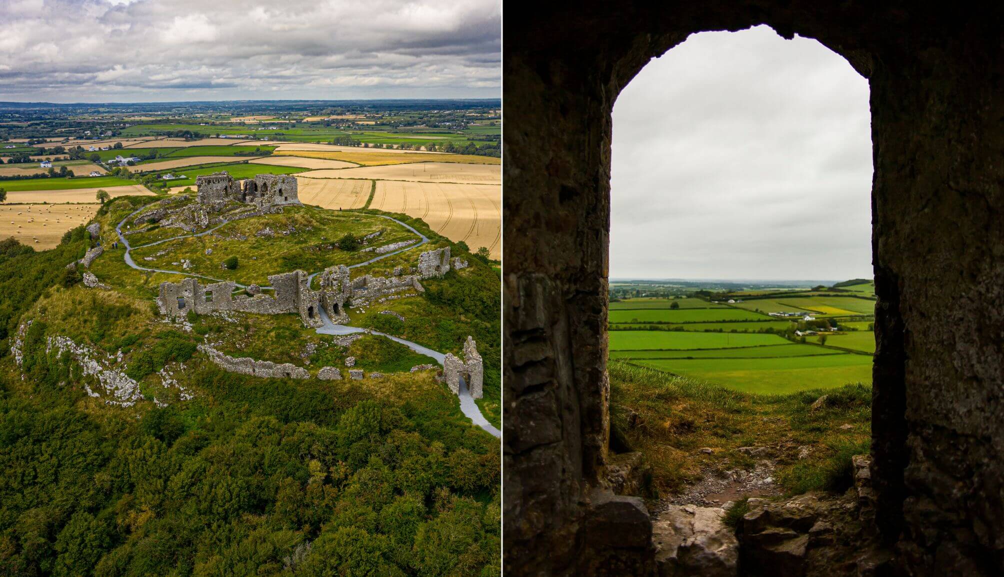
The Rock of Dunamase is a ruined hilltop fortress in County Laois, just off the N80 between Portlaoise and Stradbally, sitting 46m above a flat stretch of countryside with uninterrupted views in every direction.
From the top, you’re looking out across miles of open land towards the Slieve Bloom Mountains, with no buildings or trees blocking the line of sight. It’s exactly why the site was chosen in the first place – visibility and control.
The ruins date back to a 9th-century fort, with the stone castle added in the late 1100s during the Norman period. It’s free to visit and there are no staff members on-site.
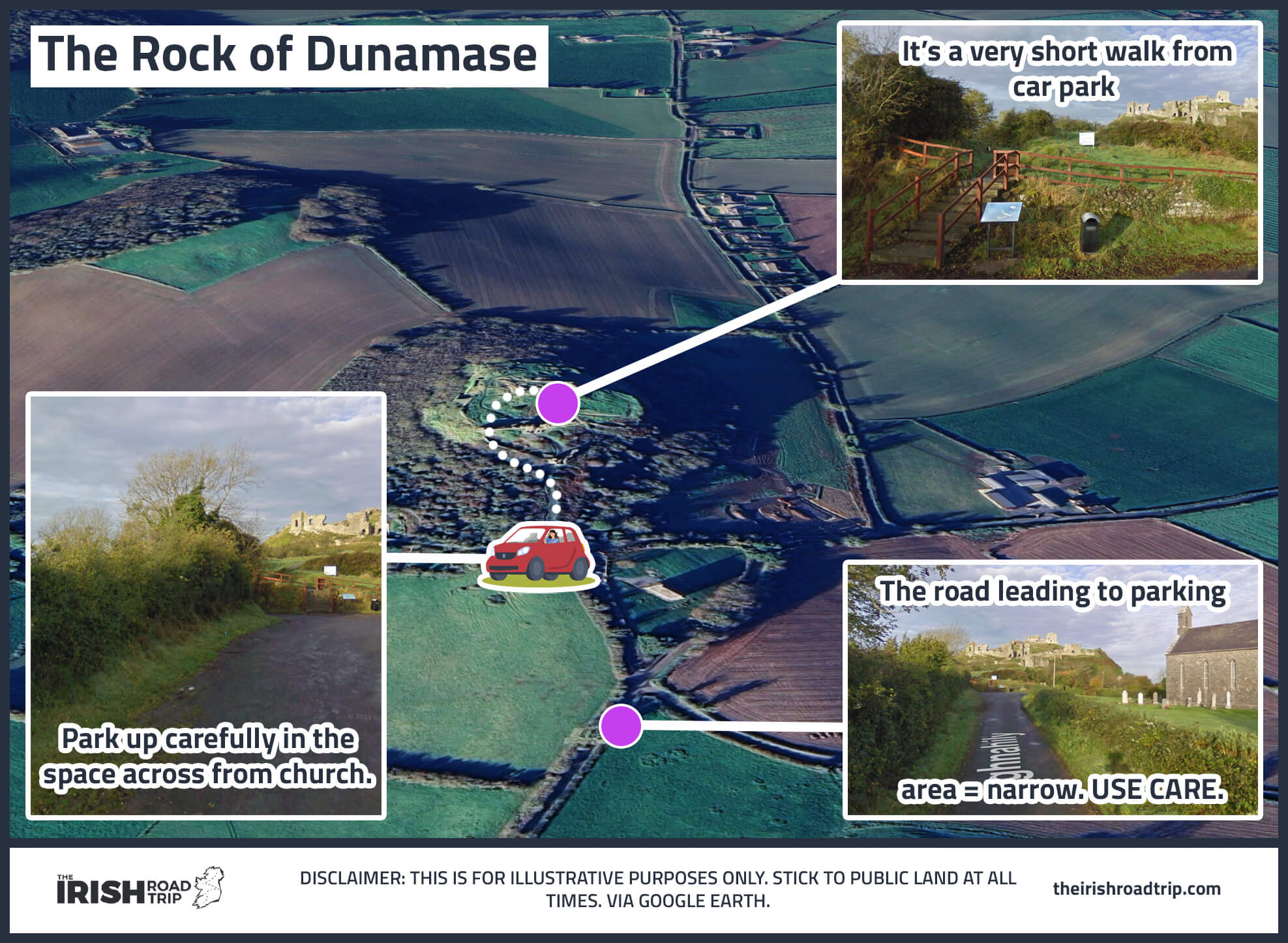
Rock of Dunamase map and visitor information
The Rock of Dunamase is state-owned and managed by the OPW, but it’s completely unguided. Access is free and limited to daylight hours.
The road leading to it
The Rock of Dunamase is off-the-beaten-path, and the roads that lead to it are what you’d expect from a rural corner of Ireland. As you can see on my map above, they are narrow, so please use caution.
The parking
There is no real car park here, but you’ll find a decent bit of space to park up right across from the church.
The walk to the Rock
It’s a short walk up to the Rock of Dunamase from the parking area – around 2 minutes in total, which is why it makes such a good pitstop.
Caution needed
There are steep drops and uneven ground throughout, so you need to watch your footing. I know of at least two bad ankle sprains here from people misjudging the terrain.
The history of the Rock of Dunamase

Photos via Shutterstock
Dunamase has been attacked, traded, abandoned and deliberately wrecked over the course of roughly 800 years. Most of what happened here ties back to one thing – control.
Its position made it valuable, and that meant it was rarely left to its own devices for long.
Early settlement and the Vikings
The first fort was established here in the 9th century, giving the site its name – Dún Másc, meaning “Fort of Másc”.
In 845, Vikings from Dublin attacked and killed the abbot of Terryglass during the raid. The site was already significant enough to be targeted, and exposed enough to be taken.
After that, the record goes quiet. There’s little evidence of consistent occupation through the 10th and 11th centuries, suggesting it either fell out of use or changed hands without being recorded.
Norman control and political deals
The current ruins are largely from the late 12th century, when the Normans arrived and an saw a sight that would make a perfect stronghold.
Height, visibility and control of the surrounding land – Dunamase ticked every box. It quickly became one of the most important strongholds in Laois.
In 1170, Diarmuid Mac Murrough, King of Leinster, used it as leverage. He handed Dunamase over to Strongbow to secure military support in reclaiming his kingdom. The deal also included his daughter Aoife in marriage.
From there, it passed through some of the most powerful Norman families in Ireland, including the Marshals and later the Mortimers, sitting right at the centre of regional control.
Decline and destruction
By the early 1300s, the balance of power had shifted again. The castle was attacked by Gaelic forces in 1320 and began to lose its strategic importance. By the mid-14th century, it was largely abandoned.
It later came under the influence of the O’More family, who controlled much of Laois, but it never returned to its former strength.
In 1650, during the Cromwellian campaign, it was deliberately damaged to prevent it being used as a defensive base. That was the end of it – just a slow collapse into the ruins you see today.
What to visit nearby
Photos via Shutterstock
There’s plenty of places to visit a handy spin from the Rock of Dunamase, from historical sites to areas that are great for a ramble.
1. Emo Court (20-minute drive)
A large neo-classical mansion with well-maintained gardens and woodland walks. Emo Court is the opposite of Dunamase – structured, accessible and easy underfoot. Good shout if you want to stretch the legs properly after the climb.
2. Heywood Gardens (25-minute drive)
A quieter spot with terraced gardens and views over the surrounding countryside. Heywood Gardens is polished than Emo Court but more relaxed, and there’s usually far fewer people around.
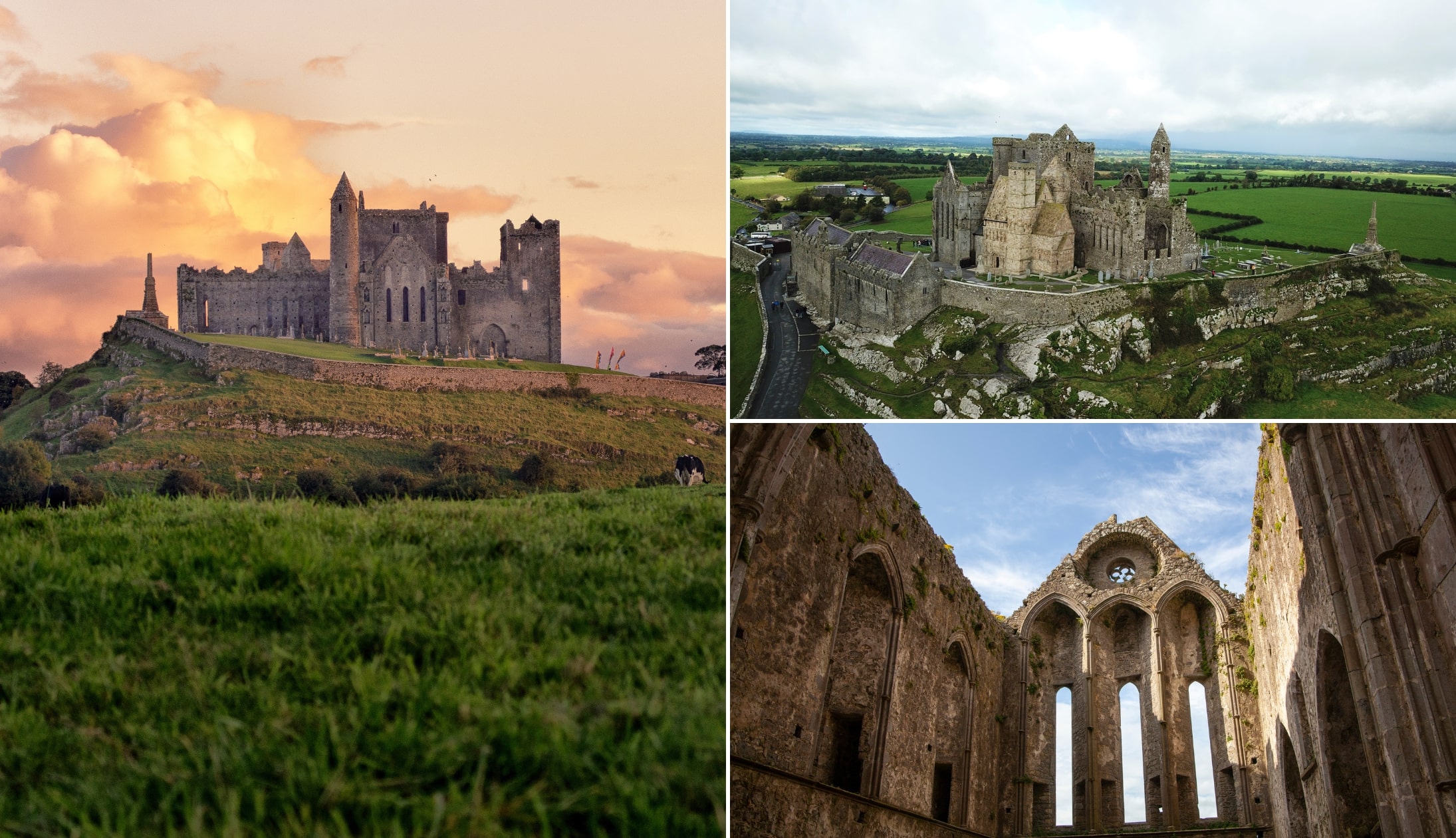
3. Rock of Cashel (1-hour drive)
The Rock of Cashel is one of Ireland’s most visited historic sites. Larger, better preserved and with proper facilities.
4. Cahir Castle (1-hour 10-minute drive)
Cahir Castle is a well-preserved medieval castle on the River Suir. Easy to explore, clearly laid out and one of the better examples of what these structures looked like when intact.
Keith O’Hara has lived in Ireland for 35 years and has spent much of the last 13 creating what is now The Irish Road Trip guide. Over the years, the website has published thousands of meticulously researched Ireland travel guides, welcoming 40 million+ visitors along the way. In 2022, the Irish Road Trip team published the world’s largest collection of Irish Road Trip itineraries. Keith lives in Dublin with his dog Toby and finds writing in the 3rd person minus craic altogether.