The Dooagh Loop Walk is one of the more overlooked things to do on Achill.
Arguably more of a local-favourite than a busy tourist trail, it’s a nice ramble that’s well worth doing if you’re staying nearby.
Below, you’ll find a map along with an overview of the Dooagh Loop Walk trail. Dive on in!
Some quick need-to-knows about the Dooagh Loop Walk

Map with thanks to Sport Ireland
Following the Dooagh Loop Walk isn’t overly difficult, but it’s worth going over the basics first.
1. Location
Dooagh is a vibrant village in the north of Achill Island, County Mayo. Achill is the largest island in the country, sitting just off Ireland’s west coast. From the mainland, Westport is the nearest large town and at just 60 km from Dooagh, you can expect the drive to take about an hour.
2. Parking
There’s a small car park at the trailhead, with enough space for around 5 cars at a push. However, there’s plenty of parking at the Dooagh Beach car park, which is just 250 metres or so from the trailhead. You’ll find the trailhead tucked down a small road beside Achill Field School.
3. Length + Difficulty
The Dooagh Loop covers roughly 4 km in total, following a series of mostly flat country lanes and gravel tracks. It’s an easy loop that’s suitable for walkers of most abilities and can typically be completed in an hour or so of gentle rambling.
4. Part of the Atlantic Drive
The Atlantic Drive is a superb way to see all that Achill has to offer. It meanders around the island taking in a number of attractions and viewpoints along the way. The drive passes through Dooagh making it easy to stop off and stretch your legs on this fantastic walk.
What to expect on the trail

Photos via Google Maps
The Dooagh Loop is a lovely meandering trail that takes you into the beautiful countryside that backs the village.
Along the way, you’ll walk alongside gently gargling streams, enjoy views of both the Slievemore and Croaghaun mountains, and see the ocean off in the distance.
The track passes several ruined stone cottages as well as the remains of an old ‘booley’ village – a village that farmers would inhabit during the summer as their cattle grazed on the nearby slopes, before returning to their villages in winter.
Spongy boglands surround the track as you leave the village behind, rich with a diverse array of flora and fauna.
An overview of the Dooagh Loop Walk
Map with thanks to Sport Ireland
The Dooagh Loop is well-signed and easy enough to follow once you reach the trailhead.
So, in this guide, we’ll just give you an idea of what to expect along the way.
Kicking things off
The trailhead isn’t too far from the beach and at the start of the walk, you’ll be enjoying views of the ocean lapping at the shore.
You’ll find a map board at the trailhead and you’ll soon see the purple arrows that guide the way. The loop can be completed either clockwise or anti-clockwise, though in this guide we’ll go clockwise.
Start by following the paved track around behind the school and houses, looping around until you reach the main road again. Cross over the road, turn left and take the first right onto ‘the Bog Road’ almost immediately.
Heading out of the village
Follow the paved road past a number of houses and cottages, with a nice stream bubbling on your left. Up ahead, you’ll see the foothills of Slievemore and Croaghaun, while Slievemore looms up to the east.
Looking back offers great views of the Atlantic Ocean and Minaun Heights beyond.
As you proceed, the cottages thin out, to be replaced by vivid green fields, plus the occasional stone ruin. The paved road breaks down to become a sandy track before veering right and away from the stream.
Across the bog
The road continues on for another 2 km or so, cutting through the surrounding bogland and crossing over streams.
You’ll follow the roadway until your path is crossed by a sandy trail on your left. Take a right here, and begin to head back to the village.
Back to the Village
The roadway gently descends back towards the village and the ocean along the edge of another pretty stream. As you near the cottages, the gravel track becomes paved once again and you’ll notice several small bridges on your left crossing the stream.
Soon enough, you’ll reach the main road again. Cross over and make your way back to the trailhead, just 30 metres away.
Alternatively, make your way to Lourdies Pub for a refreshing pint. During summer, you’ll also find the Rustic Apron Cafe set up in the car park.
Things to do near the Dooagh Loop Walk
One of the beauties of this walk is that it’s a short spin away from loads to see and do.
Below, you’ll find a handful of things to see and do a stone’s throw from Dooagh (see our Achill Food Guide if you fancy a post-walk feed).
1. Keem Beach (10-minute drive)
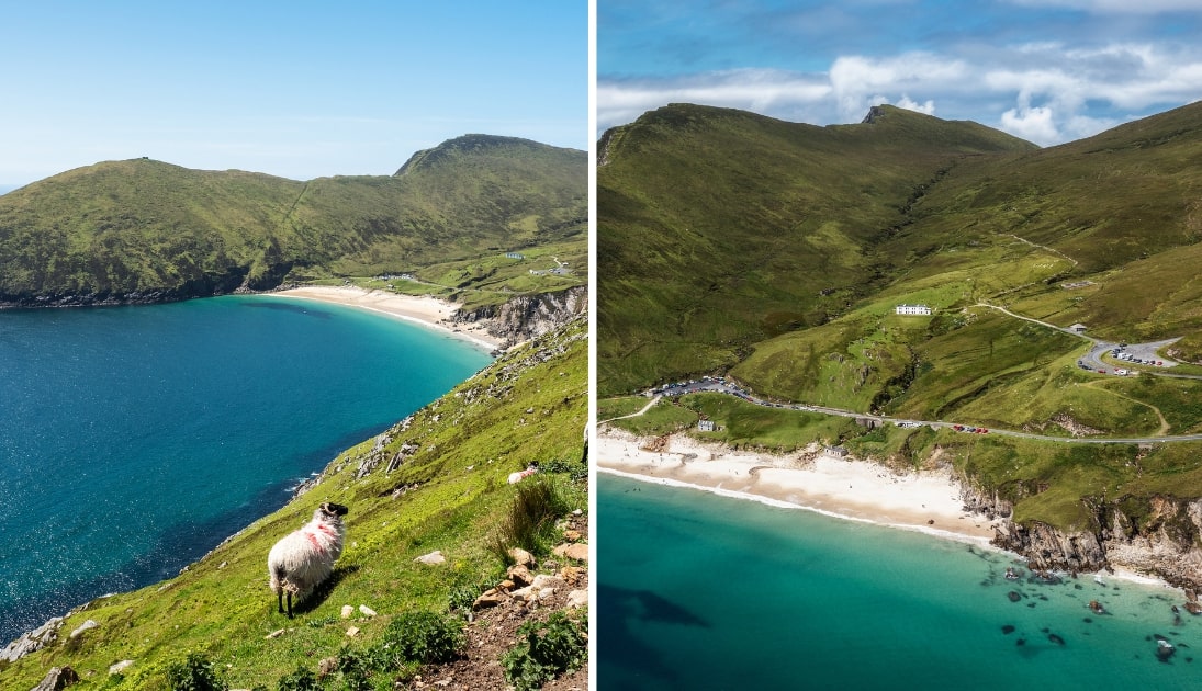
Photos via Shutterstock
The drive to Keem Beach alone is worth doing, boasting incredible views as you make your way along a winding cliff top road.
However, the beach is absolutely gorgeous, and you could be forgiven for mistaking it for a tropical island.
Gorgeous golden sands meet azure blue seas, all bordered by green slopes and backed by the mighty Croaghaun Sea Cliffs.
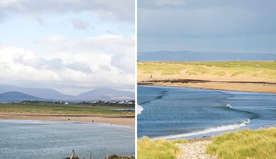
2. Dugort Beach (15-minute drive)

Photos via Shutterstock
Dugort Beach sits at the foot of the mighty Slievemore Mountain and enjoys spectacular views.
The soft sands are great for relaxing on, while the crystal clear sea invites swimmers.
Blue Flag certified with a lifeguard service throughout the bathing season, it’s a top place for a swim.
3. Golden Strand (15-minute drive)
Photos courtesy Christian McLeod via Ireland’s Content Pool
Golden Strand is another superb Blue Flag Beach on Achill Island that boasts gorgeous soft sands, dunes, gorgeous crystal clear waters, and excellent views.
It’s a superb beach for a good walk, and kayaking is also popular. In fact, avid kayakers can follow a kayak trail that leads to the nearby Dugort Beach.
Keith O’Hara has lived in Ireland for 35 years and has spent much of the last 13 creating what is now The Irish Road Trip guide. Over the years, the website has published thousands of meticulously researched Ireland travel guides, welcoming 40 million+ visitors along the way. In 2022, the Irish Road Trip team published the world’s largest collection of Irish Road Trip itineraries. Keith lives in Dublin with his dog Toby and finds writing in the 3rd person minus craic altogether.