
The Fair Head Cliffs are arguably one of the most overlooked detours off the Causeway Coastal Route.
Located on Antrim’s northeast coastline, Fair Head is an excellent spot for soaring clifftop walks with stunning coastal views.
Ancient archaeological sites and loughs add to the allure, along with views to Ballycastle and nearby Rathlin Island.
The Fair Head Cliffs

Although a visit to the Fair Head Cliffs is fairly straightforward, there are a few need-to-knows that’ll make your visit that bit more enjoyable.
1. Location
Fair Head is 4.5 miles (7km) east of Ballycastle Beach on Antrim’s northeast coast. It can only be reached on foot or by driving along the Torr Head Scenic Route. This remote area is the closest point between Ireland and Scotland (Mull of Kintyre), just 12 miles away.
2. Height
The cliffs at Fair Head rise 196m (643 feet) above sea level and can be seen for miles around. The sheer cliffs make it a popular destination for experienced rock climbers with many single-pitch climbs, crags, columns and abseiling opportunities.
3. Parking
The land at Fair Head is privately owned by the McBride family. They provide and maintain rights of way, footpaths and stiles. To help offset the cost, they make a charge of £3 for parking and an Honesty Box system is in use on the car park (here’s the location).
4. The Walks
There are several way-marked hiking trails and they all start from the car park. The longest hike is the 2.6 mile (4.2km) Perimeter Walk with Blue markers. More info on the walks below.
5. Safety WARNING
Parts of these walks are close to the cliff edge so PLEASE take extreme care during windy weather or when visibility is poor. Conditions can change quickly, so caution is ALWAYS needed. The ground can be wet and muddy so walking boots are recommended.
About the Fair Head Cliffs

Unlike other areas of the coast that are owned by the National Trust, Fair Head is private farmland. It has been owned and farmed by 12 generations of the McBride family.
Climbers and walkers share the land with grazing cows and sheep.
Fair Head boasts centuries of Irish history, including ancient Crannógs (artificial islands on lakes).
They were constructed as secure dwelling places for kings and prosperous landowners between the 5th and 10th centuries.
Dún Mór is the site of a fortified dwelling dating back over 1200 years and occupied until the 14th century. It was recently excavated by archaeologists from Queen’s University, Belfast.
Another prehistoric site at Fair Head is the Druid’s Temple, a round cairn with a 15m diameter and a tomb at the centre.
Now a popular place for rock climbing and hiking (there are 3 way-marked trails), Fair Head continues to deliver breathtaking coastal views in a timeless landscape.
The Fair Head Walk

There are three different walks to tackle from the car park mentioned above: the Blue Route aka the Bealach Runda Walk (4.2km) and the Red Route aka the Lough Dubh Walk (2.4km).
You’ll find an info panel in the car park with details on each of the walks, so make sure to stop and check it out. Here’s an overview:
Bealach Runda Walk (Blue Route)
The longest hike is the 2.6 mile (4.2km) Perimeter Walk, also known as the Fairhead an Bealach Runda Walk. It is over 3 miles (4.8km) long, heading out in a clockwise direction along the clifftop and returning on open grassland and minor roads.
It passes through the hamlet of Coolanlough and winds past Lough Dubh and Lough na Crannagh en route back to Fair Head Farm car park.
The gigantic columns (organ pipes) were formed by volcanic activity and are up to 12m in diameter. This area was the famous Sea of Moyle where mythology states the Children of Lir were put under an evil spell and exiled.
The Lough Dubh Walk (Red Route)
The Lough Dubh Walk is another popular option. This is a circular trail that boasts spectacular views and gorgeous loughs and it also follows farm tracks. Leave the car park and ramble along the road until you reach Doonmore.
This is a 65-foot grassy summit that has a little info panel in front of it detailing the history of the area. Keep tipping along the path and you’ll reach the stile.
Cross it and you’ll land in what’s often a very mucky field. Follow the way-markers and, after a short incline, you’ll be greeted with gorgeous views of Ballycastle.
Here’s where lots of care is needed – you’ll then follow the way-markers on a trail near the cliff edge (stay WELL CLEAR of the edge).
You’ll see Rathlin Island on the horizon if the day is clear. Keep going and be on the lookout for Lough Dubh. There’s another stile here to be crossed. Follow the way-markers and you’ll arrive back at the car park.
The Game of Thrones link
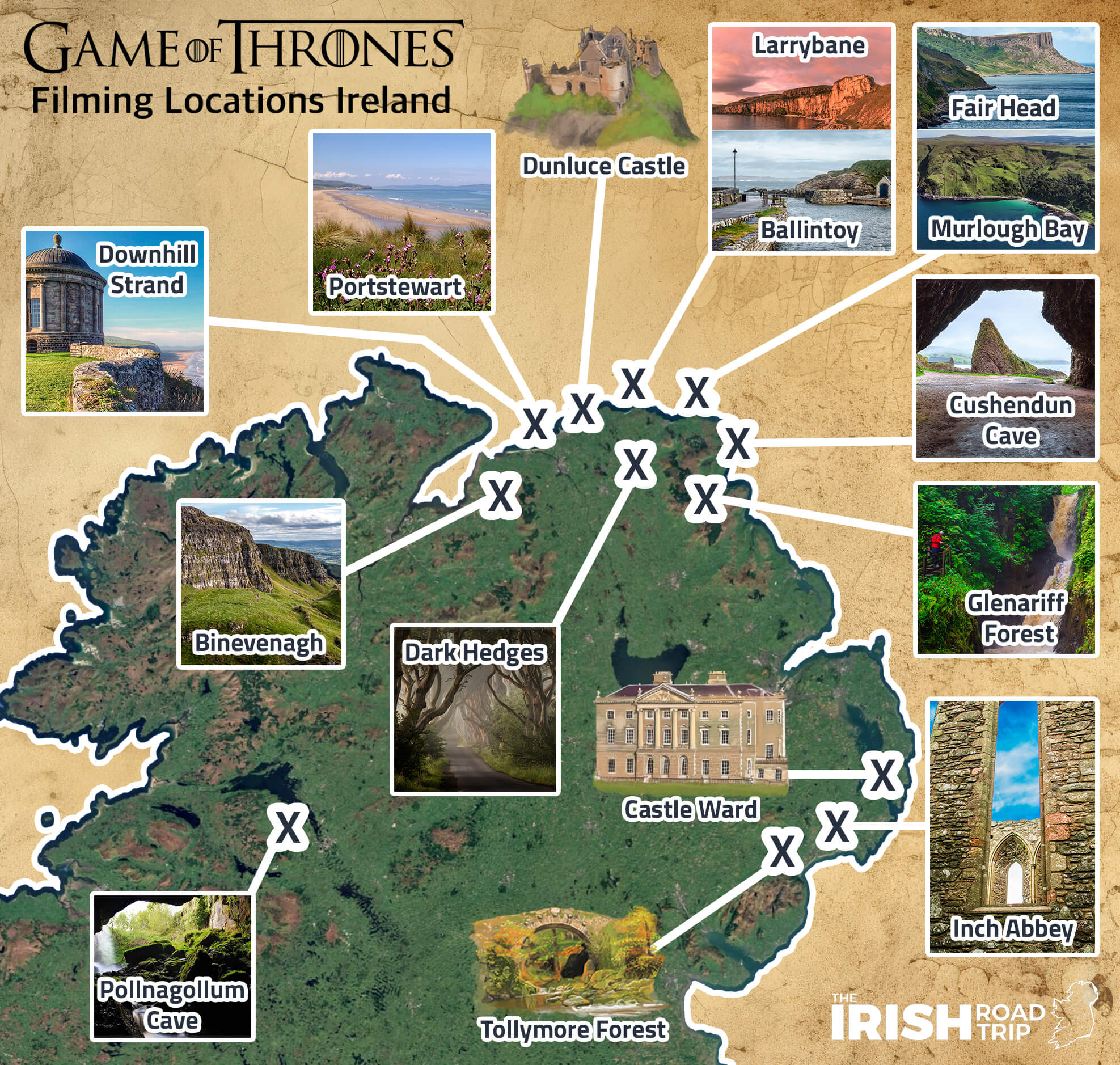
Fair Head was one of several Game of Thrones filming locations in Ireland. It was a natural choice for filmmakers looking for a dramatic set to film the Game of Thrones.
The rugged Antrim landscape frequently stars in this TV Fantasy Drama series which was filmed between 2011 and 2019.
It continues to attract fans to this dramatic area of Northern Ireland to see where the series was filmed.
Fair Head features as the cliffs of Dragonstone in Season 7, Episode 3: The Queen’s Justice. It was the backdrop when John Snow negotiated with Tyrion Lannister over dragon glass.
The spectacular cliff featured again in Episode 5: Eastwatch when John met Drogon and Daenerys and they are reunited with Jorah Mormont.
Places to visit nearby

One of the beauties of the Fair Head Cliffs is that they’re a short spin from many of the best places to visit in Antrim.
Below, you’ll find everything from a scenic drive (not for nervous drivers!) and a very hidden gem to food and more.
- Torr Head: Remote Torr Head is topped with a long-abandoned 19th century Coastguard Station. It offers views across the sea to the Mull of Kintyre, 12 miles away
- Murlough Bay: An area of remarkable beauty with old lime kilns and a ruined church, Murlough Bay never fails to impress
- Ballycastle: Home to a harbour with regular ferries serving Rathlin Island
Keith O’Hara has lived in Ireland for 35 years and has spent much of the last 13 creating what is now The Irish Road Trip guide. Over the years, the website has published thousands of meticulously researched Ireland travel guides, welcoming 40 million+ visitors along the way. In 2022, the Irish Road Trip team published the world’s largest collection of Irish Road Trip itineraries. Keith lives in Dublin with his dog Toby and finds writing in the 3rd person minus craic altogether.