
The Inishowen Head Loop is an 8.3km trail that takes around 2.5 hours to complete, depending on pace.
Arguably one of the more rewarding trails in Donegal, it showcases a quieter corner of the Inishowen Peninsula in all of its glory.
Over the course of the stroll, you’ll be treated to stunning coastal scenery and, if you visit outside of summer, the chances are you’ll have the whole place to yourself.
Some quick need-to-knows about the Inishowen Head Loop
Photos via Shutterstock
Before you pull on your hiking boots and hit the trail, let’s go over the basics. Take the 30 seconds to read the bullets below to get yourself up-to-speed:
1. Location
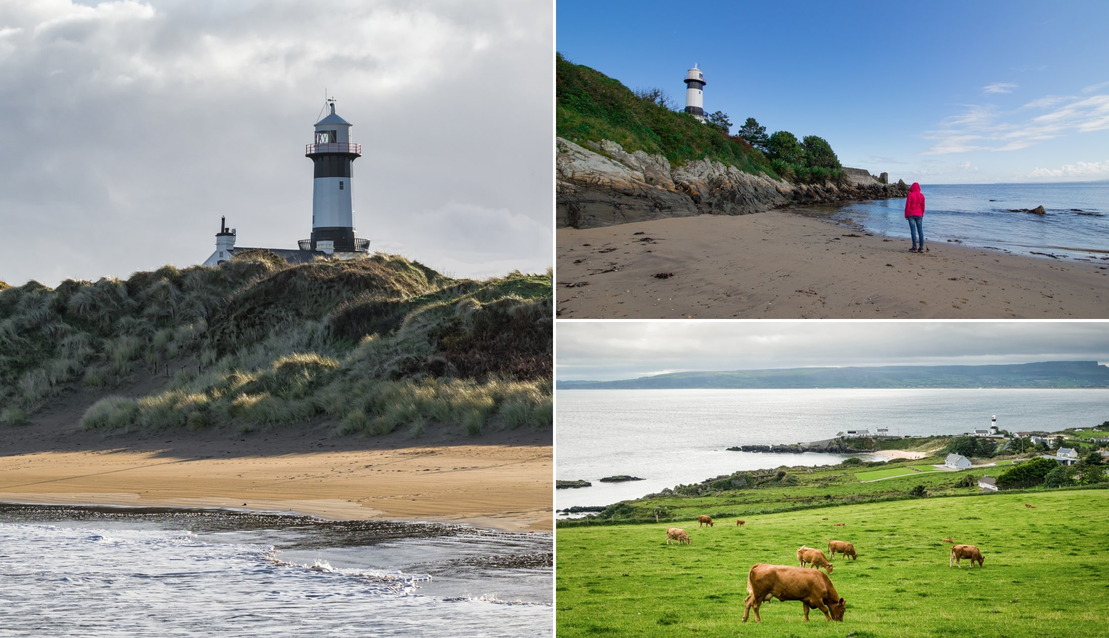
Inishowen Head marks the extreme northeastern tip of County Donegal and is just 30 km or so from the most northern point of Ireland, Malin Head. Jutting out into the Atlantic, it forms the western barrier of Lough Foyle as it spills into the sea. From the headland, it’s possible to see the the west coast of Scotland and Islay.
2. Parking
A handy car park marks the start of the walk (here on Google Maps). With space for around five cars, you’ll normally not have any trouble finding a spot. A large map of the route can be found in the car park, with signs pointing you in the right direction to get started. Alternatively, you can park at Stroove Beach Car Park (here on Google Maps), and hike the short, albeit uphill, section to the trailhead.
3. Length + difficulty
The trail covers a total of 8.3km, with an ascent of around 250 metres. With some steep climbs, it’s rated as a moderate walk. Having said that, if you possess reasonable fitness, it makes a challenging yet rewarding walk. On average, it should take around 2.5 hours to complete.
4. Part of the Inishowen 100
The Inishowen 100 is one of the most scenic drives in Ireland. It stretches for around 100 miles, taking in much of Inishowen Head, including sections of this looped walk. If you’re planning to enjoy the drive, it’s worth checking out the walk as well.
5. Not the Inishowen Peninsula Loop
You’ll often see this walk referred to as the ‘Inishowen Peninsula Loop’ online. This only takes you around Inishowen Head, if you’re looking to walk around the entire peninsula, you’re looking at a much, much longer walk.
An overview of the Inishowen Head Loop

The Inishowen Head Loop tackles a range of trails, including boggy paths, country roads, and cliff top walks.
Along the way, you can expect to enjoy diverse scenery, from the initial craggy cliffs to soggy marshlands and finally summit views across the surrounding countryside.
Starting the walk
You can complete the loop in either direction, though for this guide I’m going to recommend that you go clockwise.
While you can park in this car park, for this guide I’m going to outline the trail from Stroove Lighthouse.
When you meet the main road, take a left. Follow the road for about 800-metres and when you reach Carrowtrasna Road, take a right.
Climbing Crocknasmug’s Shoulder
Crocknasmug is a peak on Inishowen Head that reaches 322-metres in height. The trail now begins to climb as you follow a laneway that shortly turns into a bog path as it skirts the summit of Crocknasmug.
After about 1km, you’ll reach a T-junction. Take a right here and continue to climb.
After another 1km, you’ll reach the highest point of the walk, but if you want to reach the summit, you’ll need to leave the trail for a bit and head left, where you can clearly see the peak.
The path downhill
The track now leads downhill along a remote stretch. The only signs of life are the disused farmstead ahead of you, at the foot of Glenanes Hill.
You’ll notice two trails on your left, but keep heading straight on the main path as it sweeps around to the east and towards the ocean.
The path soon curves round again, leading back to the car park on a mostly flat trail that turns from muddy track to gravel path to tarmacked country road.
The final section
Enjoy the incredible views along this stretch and don’t forget to look back!
As you near the car park, you’ll see a plaque on the left-hand side of the road which marks Portkill, the place that St. Columba set sail to Iona from.
There’s also a nice seated viewpoint on the right-hand side. From here, it’s a short 500 metre walk back to the car park and the end of the walk.
Things to do nearby
One of the beauties of the Inishowen Head Loop is that it’s a short spin away from many of the best places to visit in Donegal.
Below, you’ll find a handful of things to see and do a stone’s throw from Inishowen Head!
- Stroove Beach (2-minute drive): A small beach with an iconic lighthouse as a backdrop
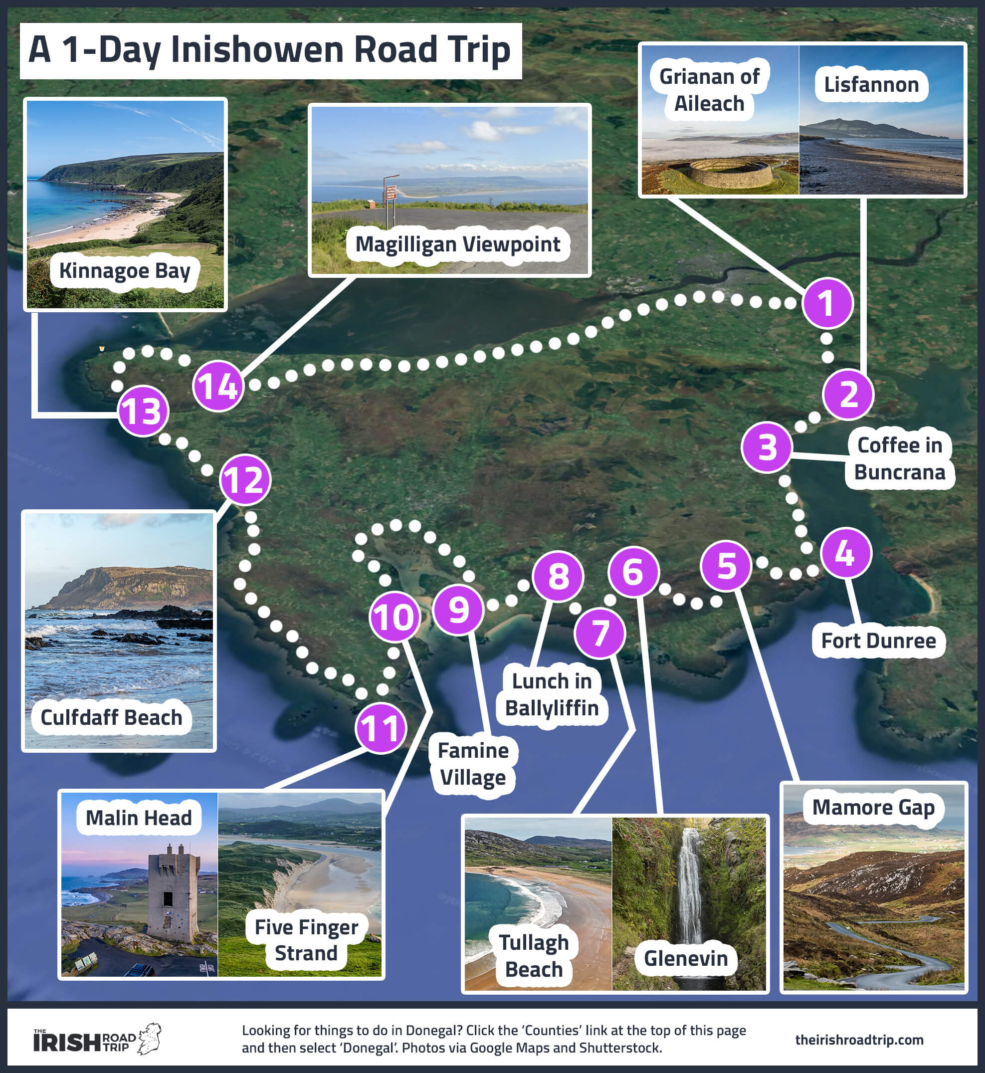
- Kinnagoe Bay (15-minute drive): A beautiful, sheltered little beach surrounded by rugged coastline and cliffs
- Magilligan Point View (15-minute drive): One of the Wild Atlantic Way’s best kept secrets (a lovely viewpoint)
- Malin Head (45-minute drive): The most northerly tip of Ireland and a land of stunning scenery
Keith O’Hara has lived in Ireland for 35 years and has spent much of the last 13 creating what is now The Irish Road Trip guide. Over the years, the website has published thousands of meticulously researched Ireland travel guides, welcoming 40 million+ visitors along the way. In 2022, the Irish Road Trip team published the world’s largest collection of Irish Road Trip itineraries. Keith lives in Dublin with his dog Toby and finds writing in the 3rd person minus craic altogether.