
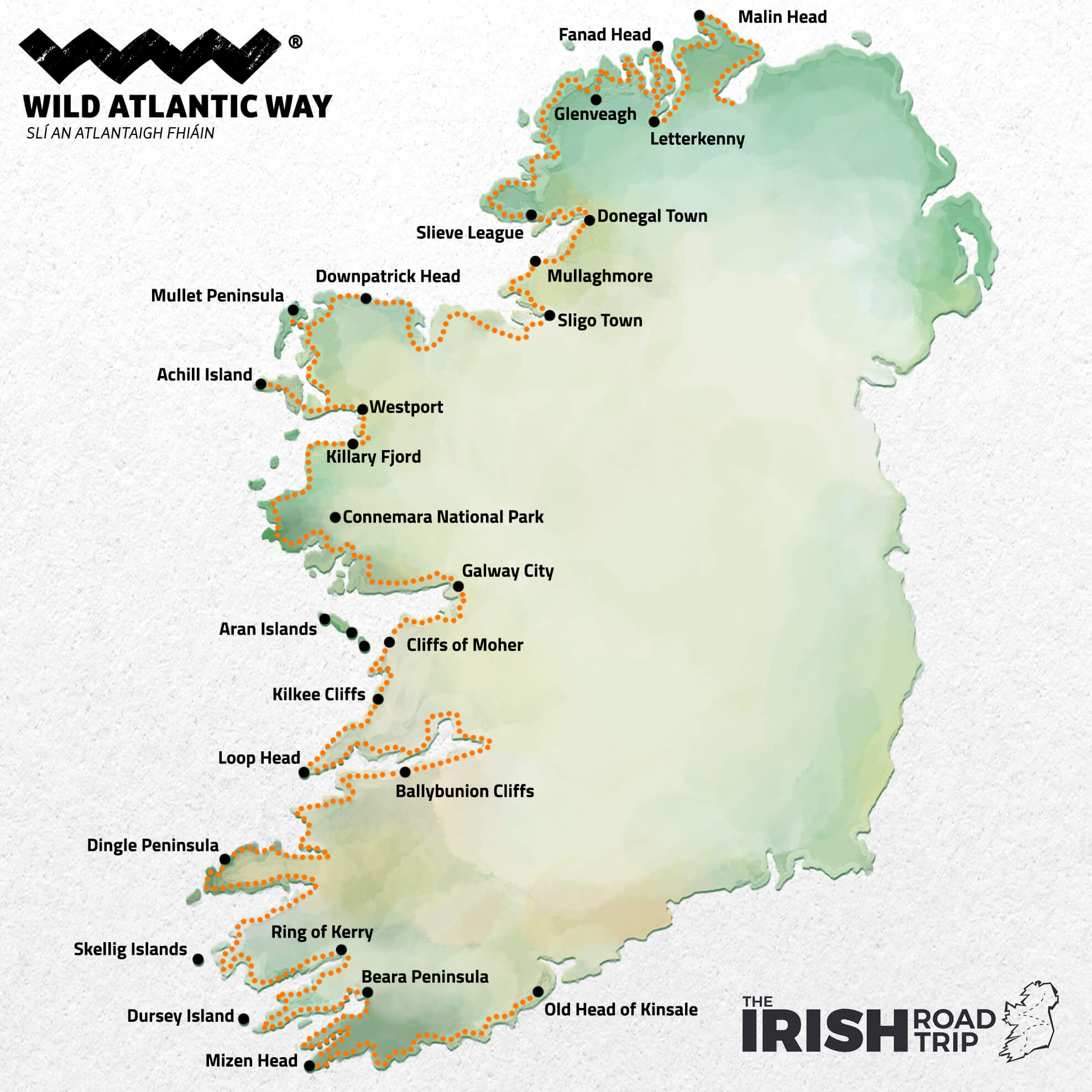
The Wild Atlantic Way in Ireland is a mammoth of a route.
It stretches for 2,500km (1,553m) and it takes in some of the islands finest coastline.
While its ‘official’ start and end points are Donegal (Inishowen) and Cork (Kinsale), you can tackle chunks of it at a time, too.
Some quick need-to-knows about the Wild Atlantic Way
Take 15 seconds to read the points below, first, as they’ll get you up-to-speed on the Wild Atlantic Way quickly:
1. What it’s all about
The Wild Atlantic Way is a coastal route that spans the stunning west coast of Ireland. The route boasts historical spots, natural wonders and many of Ireland’s top attractions, like the Cliffs of Moher.
2. Where it starts and ends
The Wild Atlantic Way route stretches all the way from the Inishowen Peninsula in Donegal to the town of Kinsale on the coast of Cork. You can start it from either place or you can explore chunks of it at a time.
3. Length
The Wild Atlantic Way route spans an impressive 2,500km (1,553m). It has over 180 Wild Atlantic Way Discovery Points dotted along it, each of which is marked with a bronze Wild Atlantic Way sign.
4. Counties included
The Wild Atlantic Way goes through all of the 8 counties along the west coast of Ireland.
- Cork
- Kerry
- Clare
- Galway
- Mayo
- Sligo
- Leitrim
- Donegal
5. How long it takes
We’ve done the maths and we estimate that it would take you around 44 hours to drive the entire 2,500km of the Wild Atlantic Way – and that’s just the driving time! You could spend anywhere from a month to a week exploring the main things to do on the Wild Atlantic Way, so it’s important to be realistic about how much time you have and prioritise your favourite sites.
6. Notable attractions
The Wild Atlantic Way takes in some of the most famous Irish landmarks including the Cliffs of Moher, the Ring of Kerry and the Dingle Peninsula. We’ll show you the main attractions by county below.
About the Wild Atlantic Way
Photos via Shutterstock
The Wild Atlantic Way was officially launched in 2014 but new Discovery Points, look outs and visitors centres have been added since.
This tourist trail spans the entire west coast of the island and because of that, it takes tourists through popular areas as well as some incredible spots off the beaten track.
The route encompasses the most southerly point of the island at Mizen Head, the most northerly point at Malin Head and the westernmost point of Europe at Dunmore Head on the Dingle Peninsula.
The trail is well known thanks to a vigorous marketing campaign and the ‘w’ shaped iron markers that mark the Discovery Points along the route. It is well signposted and easy to navigate.
Asides from the ‘w’ marked Discovery Points, there are also Wild Atlantic Way information signs all along the trail relating local history and folklore.
The counties along the Wild Atlantic Way
Photos via Shutterstock
1. Cork
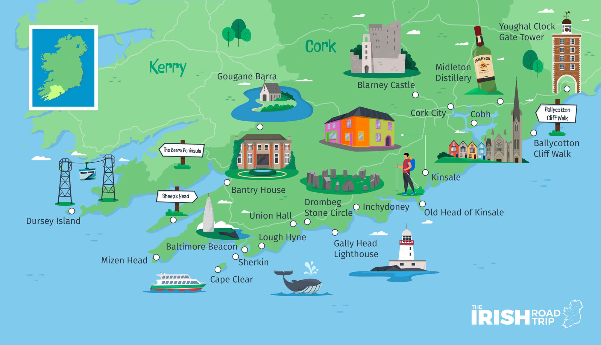
Nicknamed ‘The Rebel County’, Cork is located in the southwest of Ireland and it’s the largest county. The nickname dates back to the 15th century but more recently refers to the role the county played in the War of Independence and the Civil War.
Cork City is located in the southern part of the county and is the second largest city in the republic. The city is known for sites like the English Market and Blackrock Castle as well as for having great restaurants and pubs.
West Cork is the beautiful and quiet coastal region along the Atlantic Ocean that is known for its colourful villages, remote islands and thriving art scene.
- Size + population: 7,500km2 + 542,868 people (2016)
- Best known for: The River Lee, Roy Keane, it’s claim as ‘the real capitol’ and food, glorious food
- Key attractions: Blarney Castle, The Blarney Stone, Spike Island, Mizen Head
- Notable towns + villages: Kinsale, Cobh, Bantry, Clonakilty, Skibbereen
Related read: Check out our guide to 30 of the best things to do in Cork
2. Kerry

County Kerry, also known as ‘The Kingdom’, is famous for its outstanding natural beauty, from the Lakes of Killarney to the towering Carrauntoohil, the highest mountain in Ireland.
The county is a popular destination for outdoor lovers due to the Macgillycuddy’s Reeks, Slieve Mish mountains and Mount Brandon on the Dingle Peninsula.
The Ring of Kerry and the Dingle Peninsula are two of the most popular tourist attractions in the county, attracting at least a million tourists a year.
The islands off the coast of Kerry – Valentia, the Skelligs and the Blaskets – are beautiful remote spots steeped in Irish history and culture.
- Size + population: 4,807km2 + 147,707 people (2016)
- Best known for: Most All-Ireland Football wins, tallest mountains in Ireland, John B. Keane, Kerry Gold and Murphy’s Ice Cream
- Key attractions: Killarney National Park, The Ring of Kerry, The Slea Head Drive and the Gap of Dunloe
- Notable towns + villages: Killarney, Tralee, Dingle Town and Kenmare
Related read: Check out our guide to 42 of the best things to do in Kerry
3. Clare

County Clare, nicknamed ‘The Banner County’, is home to The Burren National Park, a rugged and desolate looking limestone landscape that makes up most of the coast.
This area was formed by glaciers during the last ice age and is known as a ‘karst’ landscape.
The Burren only looks desolate, it is actually home to an impressive amount of flora and fauna and has some incredible historic and prehistoric sites dotted throughout it – proving that humans have lived here for centuries.
The county is also a hub for traditional Irish music with multiple villages from Feakle to Miltown Malbay hosting popular Irish music festivals throughout the year.
- Size + population: 3,450km2 + 118,817 people (2016)
- Best known for: The matchmaking festival, traditional Irish music, surfing, the Father Ted house
- Key attractions: Cliffs of Moher, Bunratty Castle and Loop Head
- Notable towns + villages: Doolin, Ennis, Lisdoonvarna and Lahinch
Related read: Check out our guide to 32 of the best things to do in Clare
4. Galway

Galway sits at the southern border of Connacht and is home to the province’s only hurling team (which competes in the Leinster championship because no one else will play with them.)
Galway has some incredible natural wonders including Killary Harbour and Lough Corrib, the largest lake in the republic. The county has strong ties to Irish culture and language.
Connemara National Park, just north of Galway City, is one a place of immense natural beauty while Galway City is home to a diverse and eclectic arts scene and was named the European Capital of Culture in 2020.
- Size + population: 6,151km2 + 258,058 people (2016)
- Best known for: Festivals, Connemara Marble, The Fields of Athenry and Aran sweaters
- Key attractions: The Aran Islands, Connemara, Kylemore Abbey and the Spanish Arch
- Notable towns + villages: Galway City, Clifden, Kinvara, Athenry
Related read: Check out our guide to 41 of the best things to do in Galway
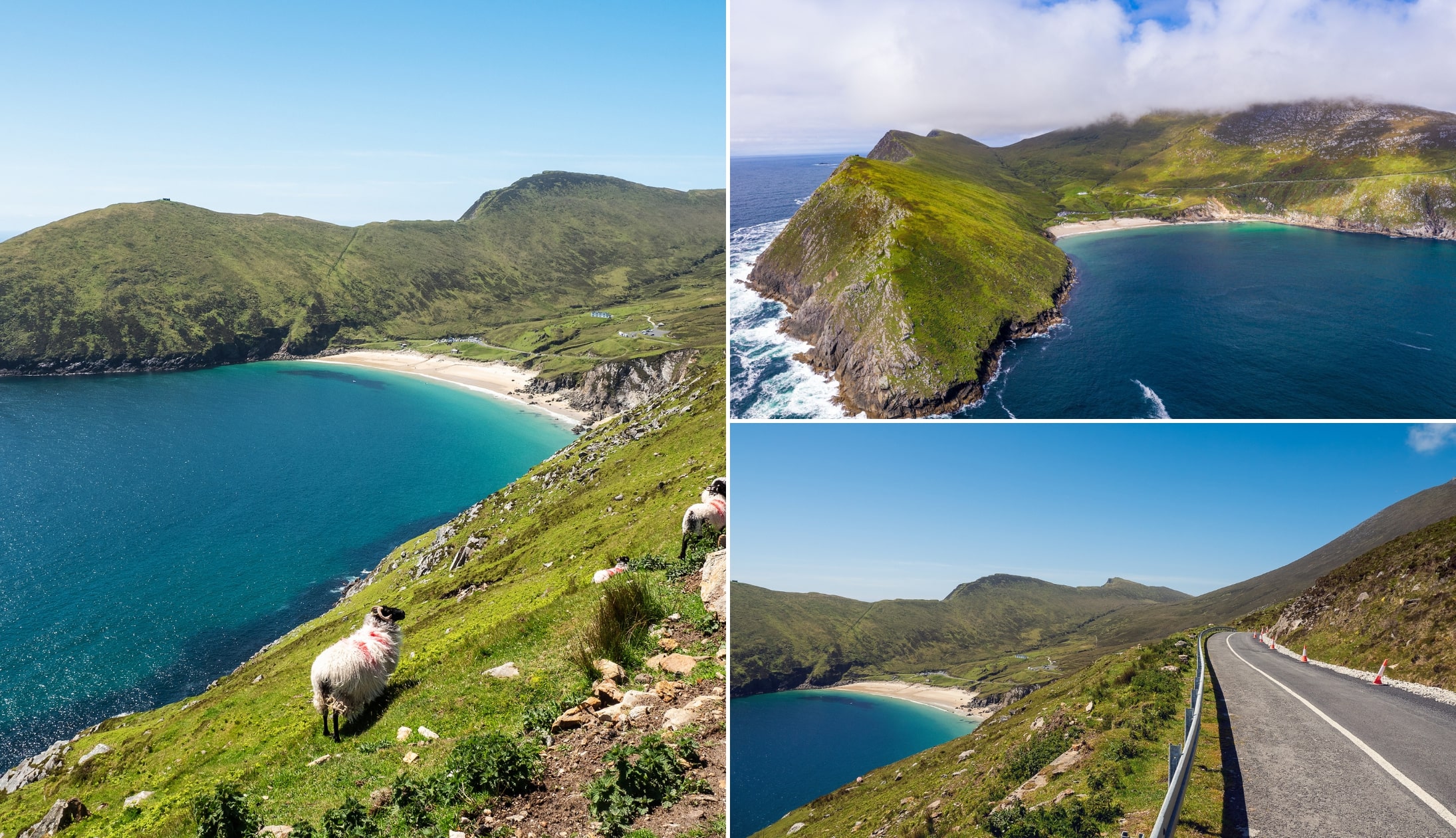
5. Mayo

The famous pirate queen Granuaile (Grace O’Malley) was born in Mayo in the 16th century and her strongholds still stand along the coast. The largest island in Ireland is in Mayo. Achill Island lies just off the coast and is easily accessible via a bridge.
Achill has incredible beaches, ancient portal tombs and the Croaghaun sea cliffs which are the tallest in Ireland, soaring 688m over the Atlantic Ocean.
Croagh Patrick is a pilgrimage site and popular hike just outside of Westport. The summit of Croagh Patrick on a clear day gives incredible views of Clew Bay which according to local folklore, has 356 islands, one for every day of the year.
- Size + population: 5,588km2 + 130,507 people (2016)
- Best known for: The Mayo curse, Granuaile, the term ‘boycott’, Knock, Mary Robinson and Sally Rooney
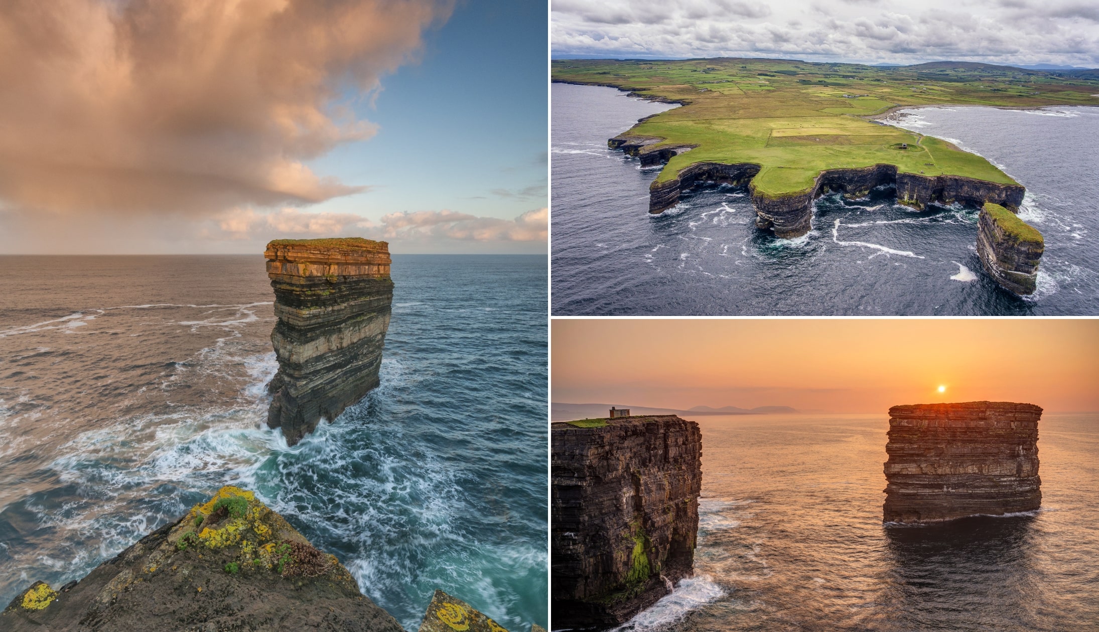
- Key attractions: Downpatrick Head, Keem Bay, Doolough Valley and the Céide Fields
- Notable towns + villages: Westport, Cong, Ballina and Castlebar
Related read: Check out our guide to 23 of the best things to do in Mayo
6. Sligo

Sligo is a county that is steeped in history and folklore. There are multiple areas throughout the county that are related to Irish mythology.
The legendary Queen Medb is supposedly buried beneath a cairn on top of Knocknarea which can be seen all the way from Sligo town.
The Caves of Keash are where the Irish king Cormac MacArt was born and raised by a wolf. And Ben Bulben, the incredible flat top rocked formation, is said to be the final resting place of the demigod Diarmuid and princess Gráinne.
Sligo Town is the largest town in the county and is built around the mediaeval settlement along the Garavogue River.
- Size + population: 1,837km2 + 65,535 people (2016)
- Best known for: WB Yeats, Jack Butler Yeats, Normal People and Constance Markievicz
- Key attractions: Ben Bulben, the Gleniff Horseshoe, Mullaghmore and Classiebawn Castle
- Notable towns + villages: Sligo, Strandhill, Enniscrone and Ballymote
Related read: Check out our guide to 29 of the best things to do in Sligo
7. Leitrim
Photos via Shutterstock
Leitrim is actually a coastal county with 4.7km of coastline wedged between Sligo and Donegal – of all of Ireland’s coastal counties, Leitrim has the smallest coastline.
The Wild Rose County is the smallest in Connacht and has the smallest population on the island. Lough Allen sits right in the centre of the county and is a popular destination for water sports enthusiasts.
Carrick on Shannon sits just south of Lough Allen and is a popular boating hub thanks to the Shannon Blueway. This beautiful village is known as the ‘marina capital of Ireland’ and is a great destination for boaters and walkers alike.
- Size + population: 1,589km2 + 32,044 people (2016)
- Best known for: Rivers, lakes and incredible scenery, only one set of traffic lights in the entire county and water sports
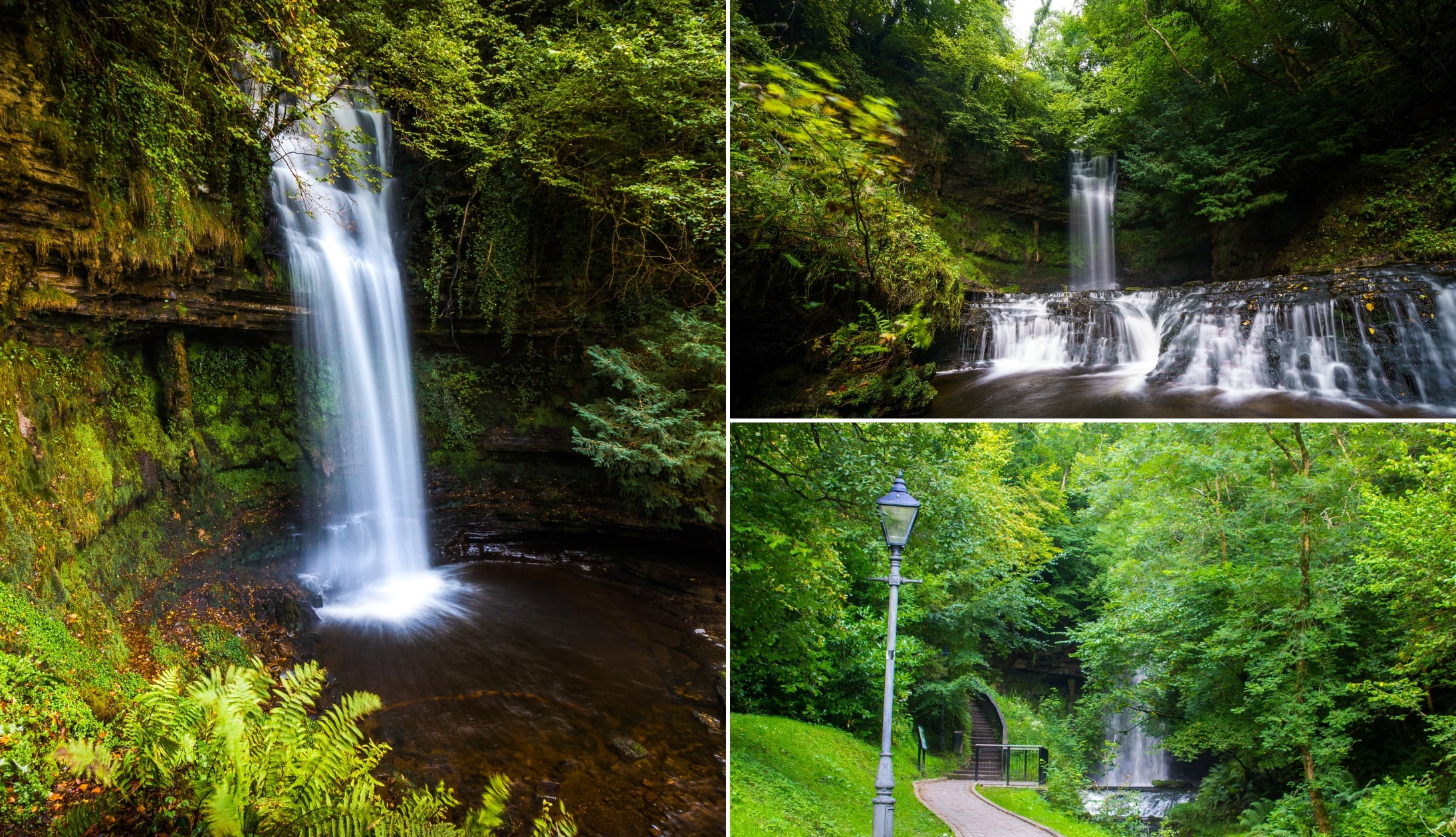
- Key attractions: Shannon Blueway, The Shed Distillery and Glencar Waterfall
- Notable towns + villages: Leitrim, Carrick-On-Shannon and Drumshanbo
Related read: Check out our guide to 17 of the best things to do in Leitrim
8. Donegal
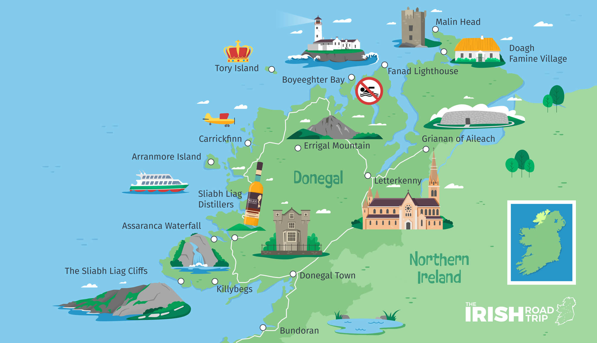
The isolated County Donegal is arguably one of the finest that the Wild Atlantic Way has to offer, and it has strong links to Irish language and culture with 37% of their population considering themselves to be Irish speakers.
The county has multiple Blue Flag beaches ideal for swimming and surfing and endless kilometres of glorious coastline.
There are multiple prehistoric and historic sites worth visiting such as the ancient Grianán of Aileach fort that dates back to 1700 BC and the 15th century Donegal Castle in Donegal Town.
- Size + population: 4,860km2 + 159,192 people (2016)
- Best known for: Not having trains, the best accent on the island, incredible beaches and traditional Irish music
- Key attractions: Errigal, Malin Head, Slieve League and Glenveagh National Park
- Notable towns + villages: Buncrana, Gweedore, Ardara, Letterkenny, Dunfanaghy and Glencolumbkille
Related read: Check out our guide to 33 of the best things to do in Donegal
How to map out your Wild Atlantic Way itinerary
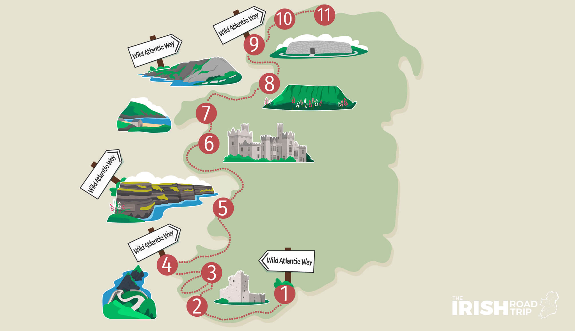
Now, we’ve created a handy 11-day Wild Atlantic Way itinerary for those of you that don’t fancy mapping out a route.
However, here are some things to consider if you fancy planning one yourself.
1. Be realistic
The Wild Atlantic Way is a huge route. As we mentioned earlier, it would take days to simply drive the entire route in one swoop.
When planning your trip you need to be realistic about how much time you have and how many sites you can comfortably visit during that time.
The last thing you want to do is over stretch yourself trying to see too many places in too short a time.
2. Prioritise (on a map!)
It’s easy to get overwhelmed with a route the size of the Wild Atlantic Way. However, if you follow the process laid out in our planning a trip to Ireland guide, you’ll remove the stress.
It’s a quick and easy step-by-step process that’ll help you whittle down what’s possible and what isn’t.
3. Find a central base/bases
If possible, try to find a central base where you can explore multiple sites from. This is easier to do if you are planning a shorter trip.
If you are planning a longer trip spanning more than a week, try to find multiple places where you can spend a couple of nights while visiting everything there is to see in the area.
4. Pull together a draft
Once you have done your research, consulted a map and looked at some accommodation options, write out a rough itinerary. From there you can decide if there are any spots you want to switch out or talk to your friends and figure out if some of your stops are not worth your time.
Feel free to leave a draft of your itinerary in the comments section. We’d love to see which part of the Wild Atlantic Way you want to explore next and offer advice if you’d like some.
A Wild Atlantic Way map with main attractions
Above, you’ll find a Wild Atlantic Way with hundreds of attractions, viewpoints and hidden gems plotted.
Yes, it’s locked, but it only takes 10 seconds to access it (and it’s free).
FAQs about the Wild Atlantic Way in Ireland
We’ve had a lot of questions over the years asking about everything from ‘What Wild Atlantic Way route is best?’ to ‘Which end is best to start at?’.
In the section below, we’ve popped in the most FAQs that we’ve received. If you have a question that we haven’t tackled, ask away in the comments section below.
How long does it take to do the Wild Atlantic Way?
If you were to drive the 2,500km (1,553m) Wild Atlantic Way without stopping, it would take you roughly 44 hours. You’ll need at least 7 days to see a good portion of it.
How long is Ireland’s Wild Atlantic Way?
Ireland’s Wild Atlantic Way is an impressive 2,500km (1,553m) and it stretches between Donegal right the way down and around to Cork.
Where does the Wild Atlantic Way start and end?
The Wild Atlantic Way can be started in either Cork (Kinsale) or Donegal (Inishowen). You can start it from either end.
Which is the best part of the Wild Atlantic Way?
What’s ‘best’ is open to debate. In our opinion, it’s hard to beat West Cork. However, Kerry (Valentia in particular) and Sligo pack a punch, also.
Keith O’Hara has lived in Ireland for 35 years and has spent much of the last 13 creating what is now The Irish Road Trip guide. Over the years, the website has published thousands of meticulously researched Ireland travel guides, welcoming 40 million+ visitors along the way. In 2022, the Irish Road Trip team published the world’s largest collection of Irish Road Trip itineraries. Keith lives in Dublin with his dog Toby and finds writing in the 3rd person minus craic altogether.