
I’ve driven the 2,500km Wild Atlantic Way over the course of 10 days and I’ve been to the different sections of it on many different occasions over the years.
While there are endless discovery points along the route, this guide focuses on what I believe are the best stops on the Wild Atlantic Way.
Some, like Killarney National Park are well known while others, like West Cork’s Sheep’s Head Peninsula, are often missed by visitors to Ireland.
The best stops on the Wild Atlantic Way
Below, you’ll find a mix of the ‘well know’ Wild Atlantic Way attractions, like Moher, to the often-missed attractions, like Slieve League.
If you’re after an interactive map with the stops plotted, see my Wild Atlantic Way map.
1. The Slieve League Cliffs

The Slieve League Cliffs on the coast of Donegal are the highest accessible cliffs in Ireland (the highest cliffs in the country are Croaghaun sea cliffs on Achill).
The cliffs rise 601m above the Atlantic Ocean and are a spectacular site. The short walk from the main car park to the cliffs takes you past an ‘EIRE’ sign from WWII.
As you can see from the map above, you can either walk up to them or take a bus from the visitor centre. Just note that it can get quite misty here, which results in the views being completely obscured.
2. Connemara’s Kylemore Abbey

Photos by the Irish Road Trip
Connemara is home to some of the most popular things to do on the Wild Atlantic Way. This is the area along the Atlantic Coast north of Galway City that is known for its incredible natural beauty as well as its strong connections to Irish language and culture.
The coastline of Connemara is made up of peninsulas, inlets and islands. The area is the largest Gaeltacht region in Ireland with around 22,000 daily Irish speakers living there.
Connemara National Park is located in the northwest of the region. It encompasses over 2,000 hectares of mountains, bogs and grasslands. Diamond Hill outside of the village of Letterfrack is one of the most popular hikes in the national park.
However, the main attraction is Kylemore Abbey, pictured above. It was founded in 1920 by Benedictine nuns who fled war-torn Ypres; originally built as Kylemore Castle in 1868 by Mitchell Henry, the 70-room mansion was later transformed into a monastery, school, and then one of Ireland’s top visitor attractions.
3. The Cliffs of Moher
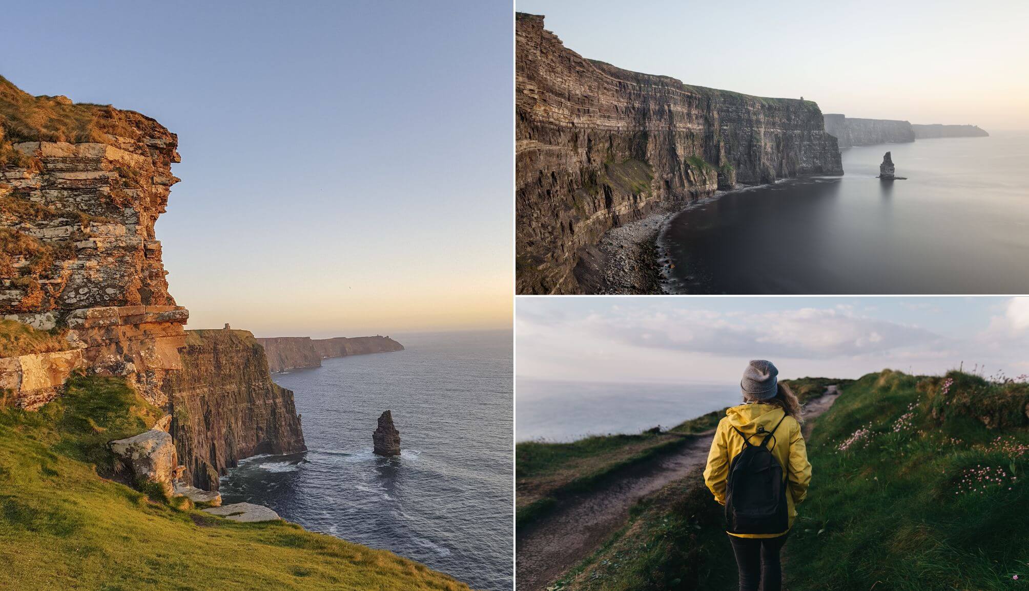
Photos via Shutterstock
The Cliffs of Moher, located between Doolin and Lahinch in Clare, are one of the best stops on the Wild Atlantic Way. These spectacular cliffs span 14km and rise 120m above the Atlantic Ocean.
On a clear day atop the cliffs, visitors can see all the way to the Maumturk Mountains in north Galway, the Aran Islands in the west and Loop Head in the south.
You can view the cliffs by boat, hike up to the cliffs from Doolin or visit the official visitors centre at the top of the cliffs which is open year round.
4. Killarney National Park

Killarney National Park encompasses 26,000 acres of woodlands, lakes and mountains. The park contains oak and yew groves of international importance, has the only red deer herd on the island and is the most extensive area of native forest in Ireland.
This national park was the first of its kind in the Irish free state when the Muckross Estate was donated to the government in 1932.
Muckross House and Torc Waterfall are two focal points in the park along with the lakes, mountains and ancient sites, like Innisfallen Abbey.
Visit the park, tackle the various things to do in Killarney and then set-off on the outstanding Ring of Kerry Drive around the Iveragh Peninsula.
5. The Burren

Located on the coast of Clare, the name ‘Burren’ comes from the Irish ‘Boirinn’ which means ‘rocky district.’ The Burren is considered to be a ‘krast’ landscape.
This entire region was shaped by glaciers during the last ice age, exposing the pitted limestone rock that makes up such a large part of the landscape.
The Aillwee Caves near Ballyvaughan show another side of this unique landscape. Aside from the natural beauty, the Burren is also home to quite a few historic and prehistoric sites such as Corcomroe Abbey and Poulnabrone Dolmen.
6. The Dingle Peninsula

The Dingle Peninsula is another place that’s home to some of the best things to do on the Wild Atlantic Way, which is why it’s one of the most popular tourist destinations along the west coast.
The town of Dingle (from which the peninsula gets its name) is a colourful seaside town with incredible pubs, great food and is just a short drive away from most of the best spots on the peninsula.
Some of these attractions include the Slea Head Drive which takes in Dún Chaoin Pier with its incredible views of the Blaskets, the village of Ballyferriter, Mount Brandon and Gallarus Oratory.
7. Kinsale
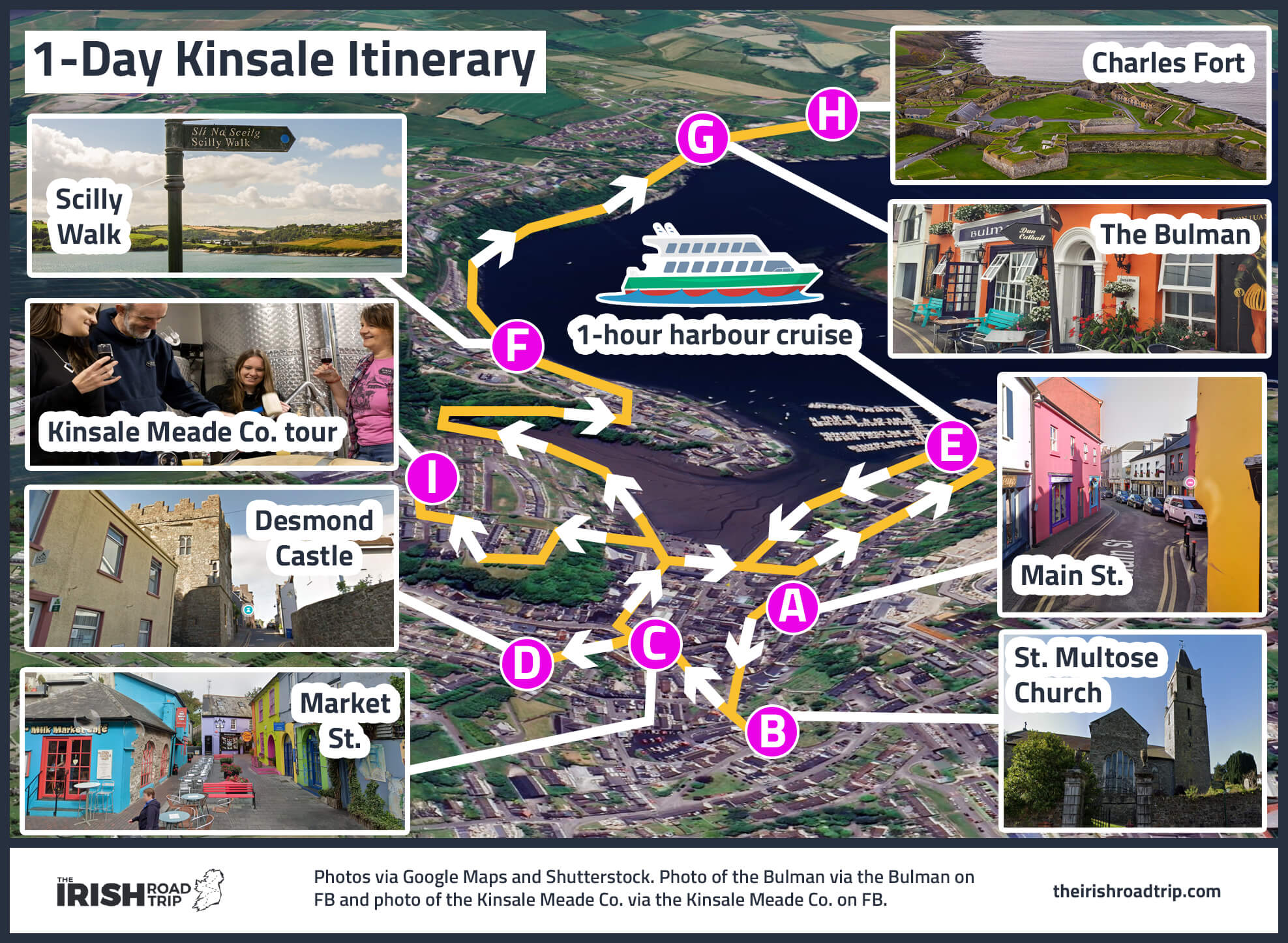
Kinsale is an idyllic seaside town in West Cork and the start (or end point) of the Wild Atlantic Way. This historic fishing town was the site of the Battle of Kinsale in 1601 which marked an end to the Nine Years War.
A couple centuries later, the Lusitania sank just off the coast from here near the Old Head of Kinsale.
This town has some great pubs and restaurants (including one with a Michelin star) as well as great seaside walks like the Scilly Walk out to Charles Fort.
8. West Cork’s wonders

You’ll discover many of the best stops on the Wild Atlantic Way in wonderful West Cork – a beautiful part of the country with colourful villages, spectacular gardens and ancient structures.
The towns of Skibbereen, Clonakilty and Bantry have great pubs, excellent restaurants and comfortable accommodation. Garnish Island, just off the coast of West Cork in Glengarriff harbour is home to one of the most spectacular gardens in the country.
The stone circle in Drombeg and the Altar Wedge Tomb outside of Schull are incredible examples of just some of the prehistoric structures in this area.
9. The Aran Islands

Some of the most overlooked things to do on the Wild Atlantic Way involve its islands.
The west coast of Ireland is dotted with islands from Spike Island in the south and Tory Island in the north to Kerry’s mysterious Skellig Islands. Many of these islands that are still inhabited are Gaeltachts and are among some of the most isolated places in Europe.
The uninhabited Blasket Islands off the coast of Kerry have spectacular beaches, incredible views of the Kerry coast and wonderful hikes around the island.
However, it’s the Aran Islands that are Ireland’s most famous. Easily accessible via Galway or Doolin (Clare), Inis Mor, Inis Oirr and Inis Meain offer a glimpse into traditional Irish life, with ancient forts, car-free roads, and windswept limestone landscapes that feel untouched by time.
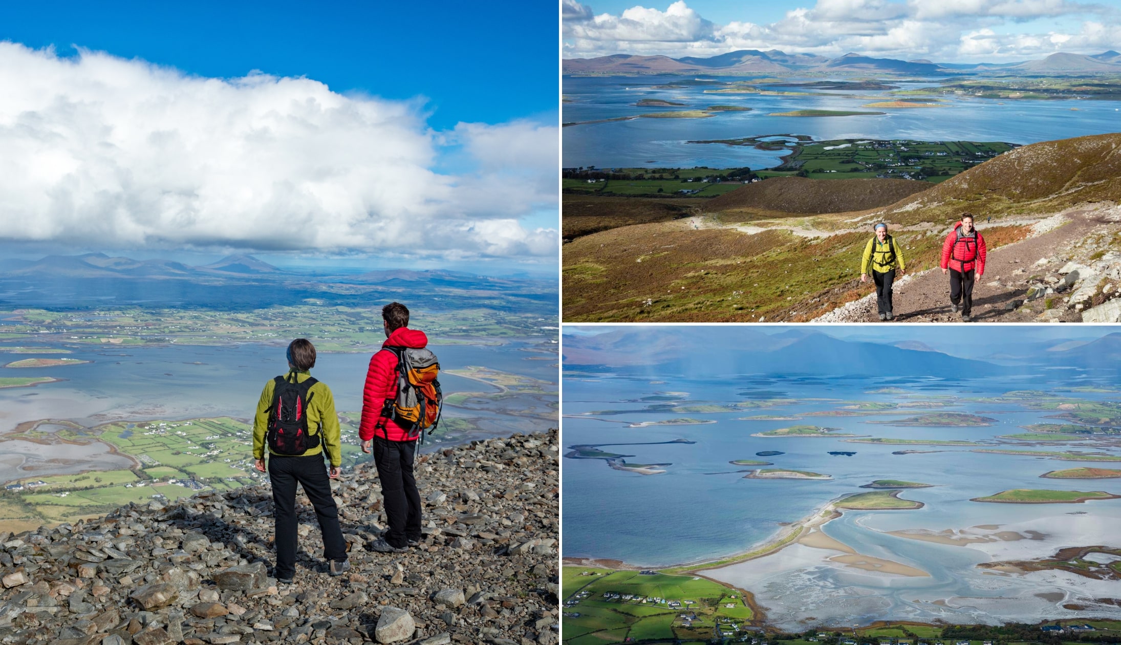
10. Croagh Patrick
Photos courtesy Gareth McCormack/garethmccormack via Failte Ireland
If you are looking for active things to do on the Wild Atlantic Way, there’s endless walking trails to choose from.
Some of my favourite hikes along the route are Diamond Hill in Galway, Errigal in Donegal, the Doolin Cliff Walk in Clare and the mighty Croagh Patrick in Mayo.
Rising 764 metres above sea level, Croagh Patrick’s quartzite peak has been a site of pilgrimage for over 1,500 years, with ties to Saint Patrick said to have fasted here for 40 days.
The climb starts just outside Westport and follows a well-trodden but steep and rocky path. It typically takes between 2.5 to 3.5 hours round-trip, depending on fitness and weather.
11. The Inishowen Peninsula
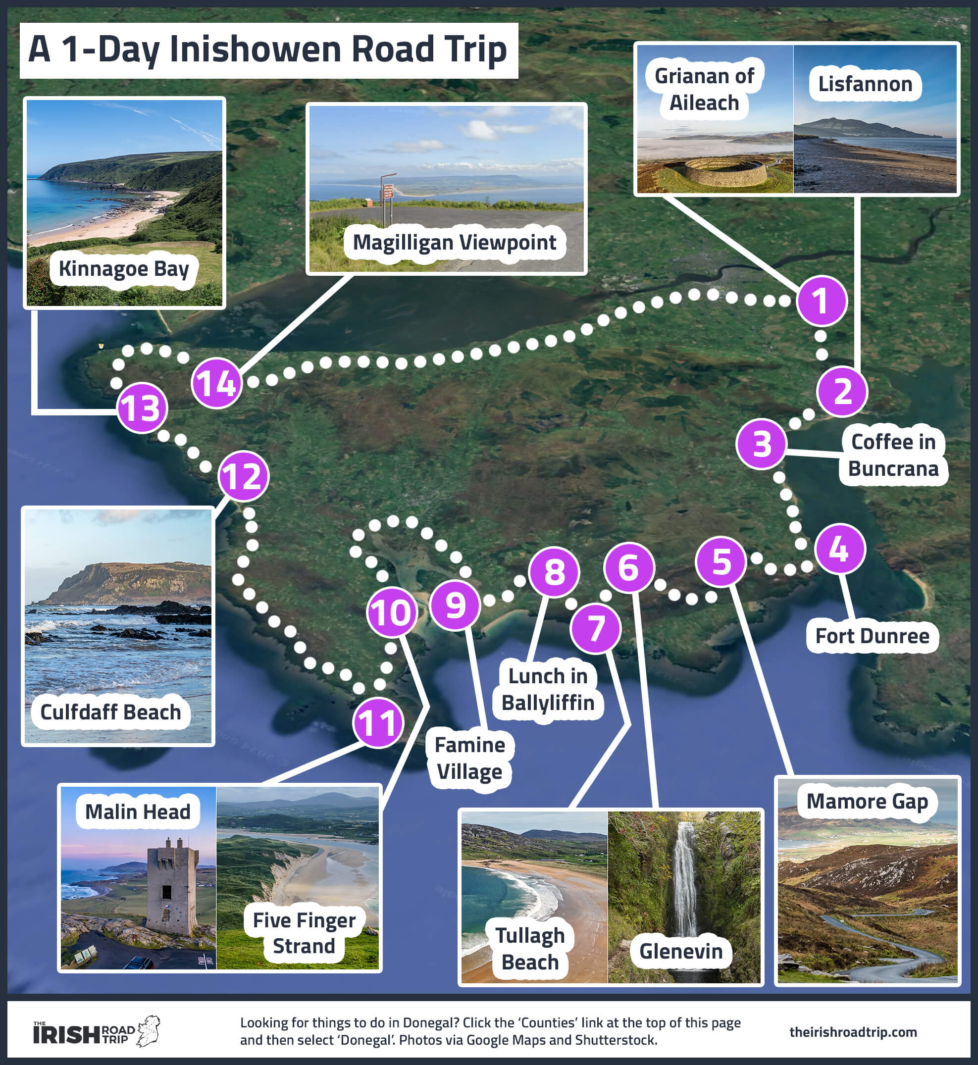
The Inishowen Peninsula boasts many of the best stops on the Wild Atlantic Way. It’s best explored by following the Inishowen 100 route.
This is a 100-mile coastal loop around Donegal’s Inishowen, packed with dramatic viewpoints, historic sites, and quiet beaches.
Some of the stand-out attractions include the very steep Mamore Gap, Ireland’s northernmost point at Malin Head, and some of the best beaches in Ireland, like Kinnagoe Bay.
12. Yeats Country
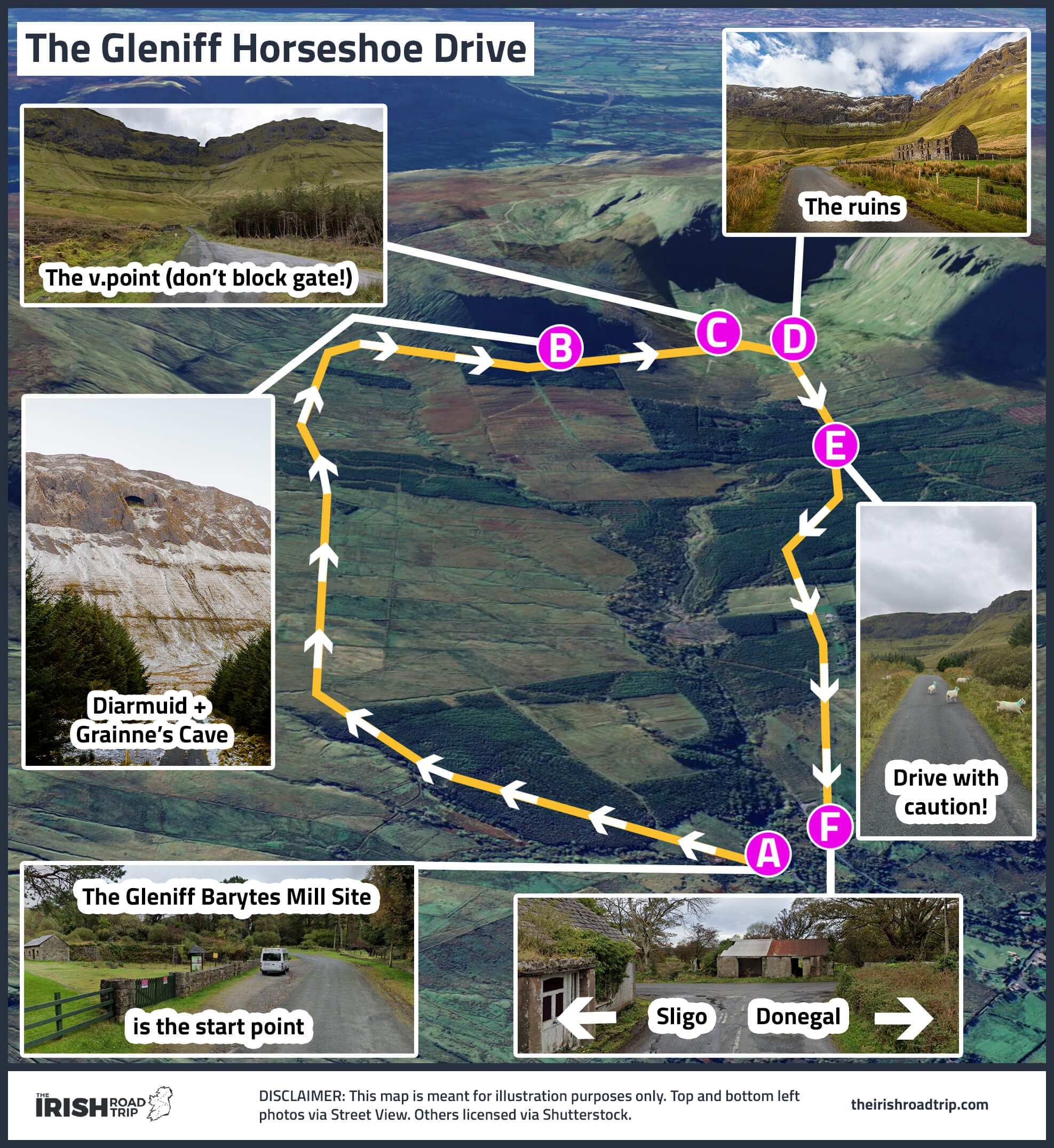
Some of the most overlooked Wild Atlantic Way attractions are found tucked away in County Sligo.
In Sligo, Benbulben towers like a stone table above green fields, ancient tombs lie undisturbed on remote hilltops, and beaches like Streedagh whisper tales of shipwrecks and storms.
You can surf, hike, soak in a seaweed bath, or stand at Yeats’ grave under that same “bare Ben Bulben’s head.” The roads are quiet, the views are wild, and the Gleniff Horseshoe is one of the best drives in Ireland!
13. The Ring of Beara

The Ring of Beara is a 148km (92-mile) loop that wraps around the Beara Peninsula, straddling the Cork and Kerry border. It’s much quieter than the nearby Ring of Kerry but just as rewarding.
The route can be driven in 3–4 hours without stops, but it’s best explored over 1–2 days to allow time for hikes, island trips, and scenic detours.
It’s typically tackled clockwise from either Glengarriff or Kenmare. Highlights include the dramatic Healy Pass, colourful villages like Allihies and Eyeries, Bere and Dursey Islands, and Gleninchaquin Park.
14. The North Mayo coast
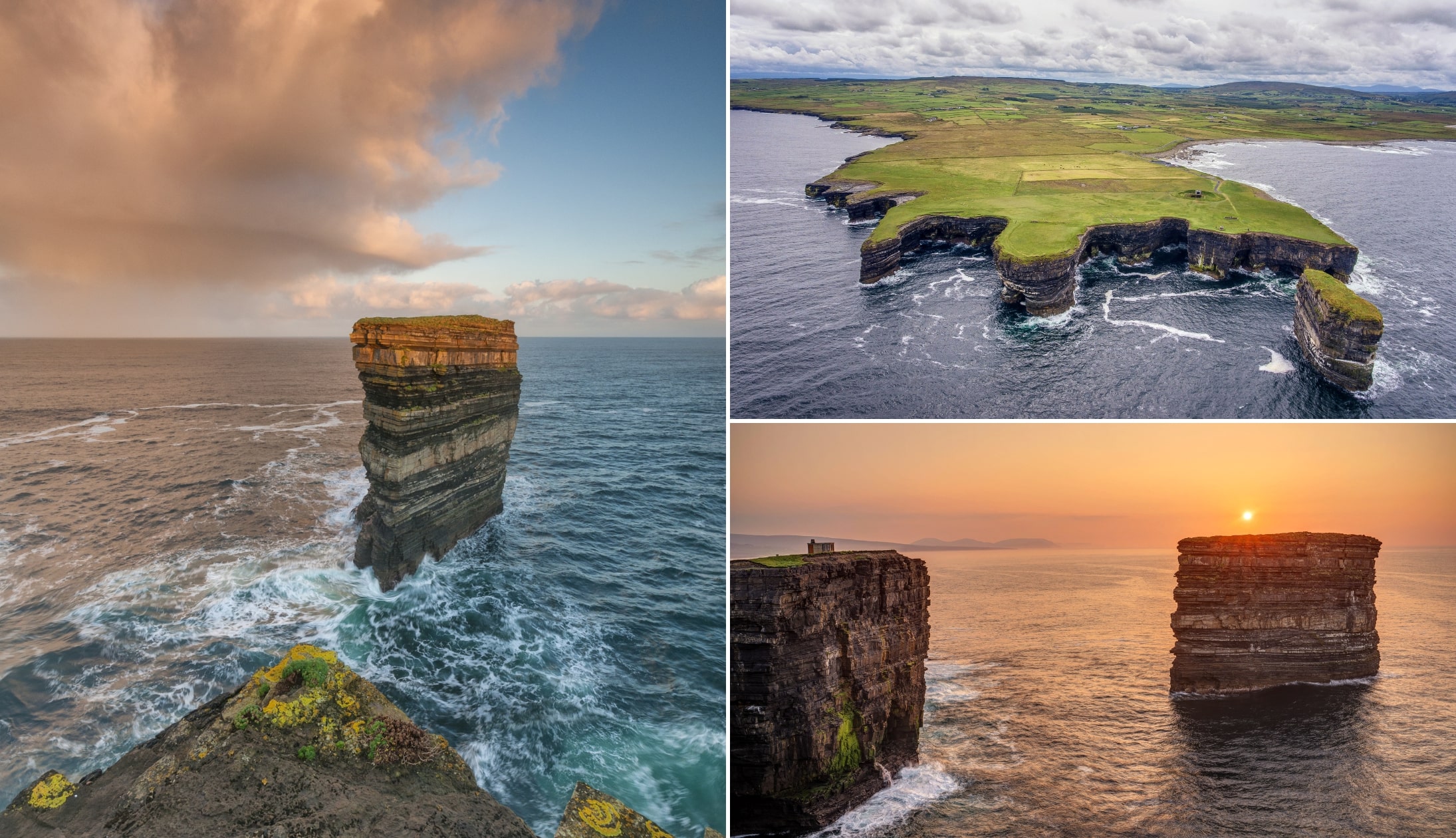
Photos via Shutterstock
The North Mayo coast is one of the Wild Atlantic Way’s most underappreciated stretches, with a mix of natural drama, history, and quiet isolation.
Key highlights include Downpatrick Head, where the sea-stack Dún Briste rises 50 metres from the Atlantic. Further west, the Belmullet Peninsula offers remote beaches, scenic loop walks, and access to Erris Head, a Special Area of Conservation.
Further along the coast, the Céide Fields sit atop dramatic cliffs and contain the oldest known field system in the world. Although every bit as scenic as nearby Achill Island, what sets this stretch apart is the quiet – fewer cars, fewer crowds, and a far stronger sense of isolation.
15. The Sky Road

The Sky Road is a 16km scenic loop starting in Clifden in Galway. Best driven clockwise, it splits into Upper and Lower sections (take the Upper for the best views).
The route climbs to 400ft, offering panoramas over Clifden Bay and the offshore islands. Key stops include Clifden Castle (reached via a 25-minute trail), the John D’Arcy Monument, and Eyrephort Beach.
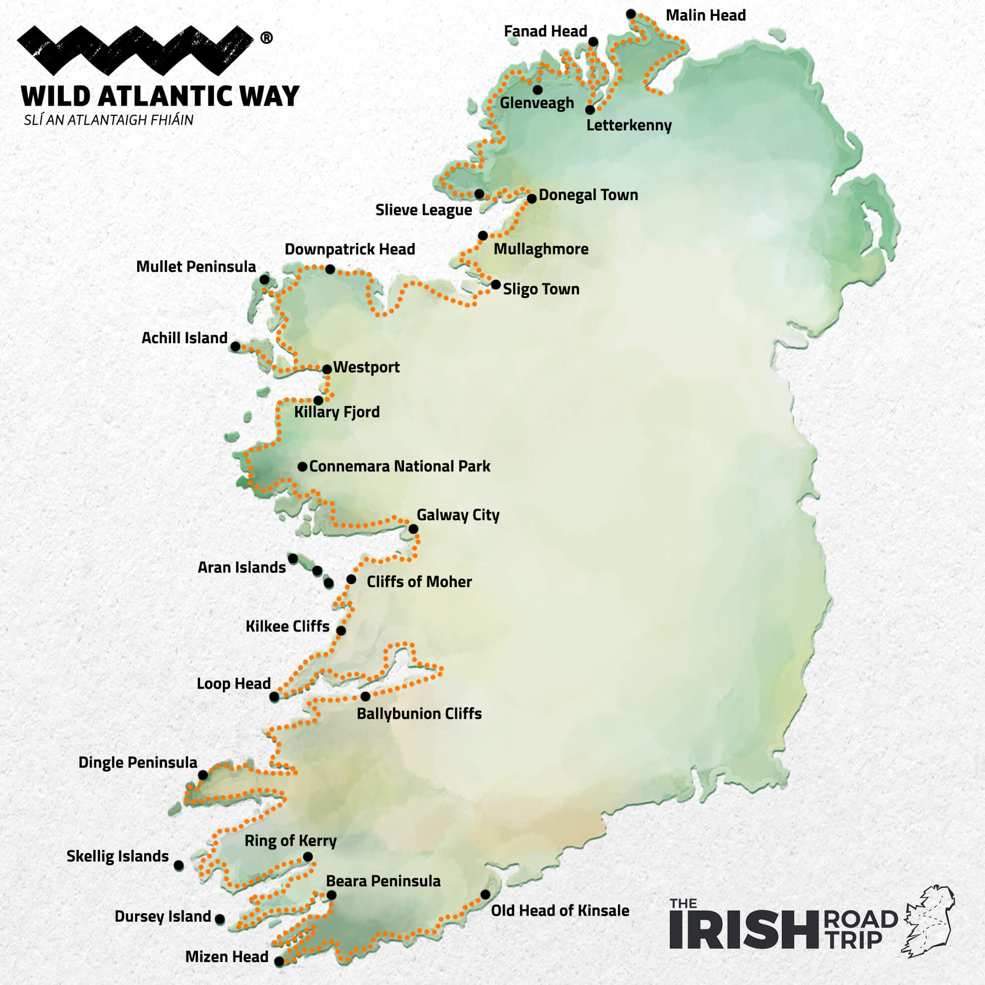
Visit the different Wild Atlantic Way attractions with this itinerary
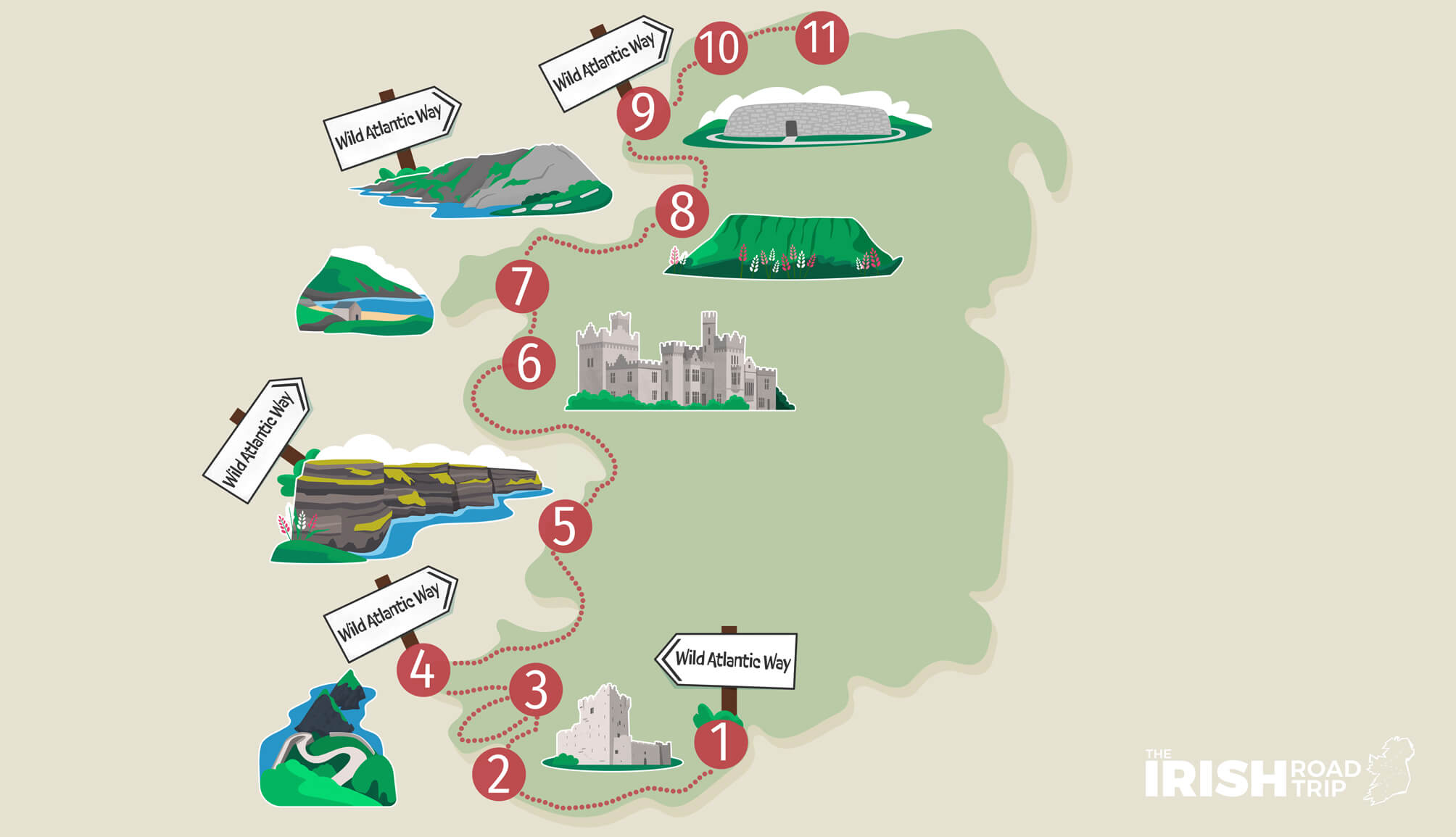
Now that you’ve a good sense of the main Wild Atlantic Way attractions, it’s time for an itinerary.
If you have 11 days to spare, this Wild Atlantic Way itinerary (pictured on the map above), will be a road trip you’ll never forget!
Keith O’Hara has lived in Ireland for 35 years and has spent much of the last 13 creating what is now The Irish Road Trip guide. Over the years, the website has published thousands of meticulously researched Ireland travel guides, welcoming 40 million+ visitors along the way. In 2022, the Irish Road Trip team published the world’s largest collection of Irish Road Trip itineraries. Keith lives in Dublin with his dog Toby and finds writing in the 3rd person minus craic altogether.