
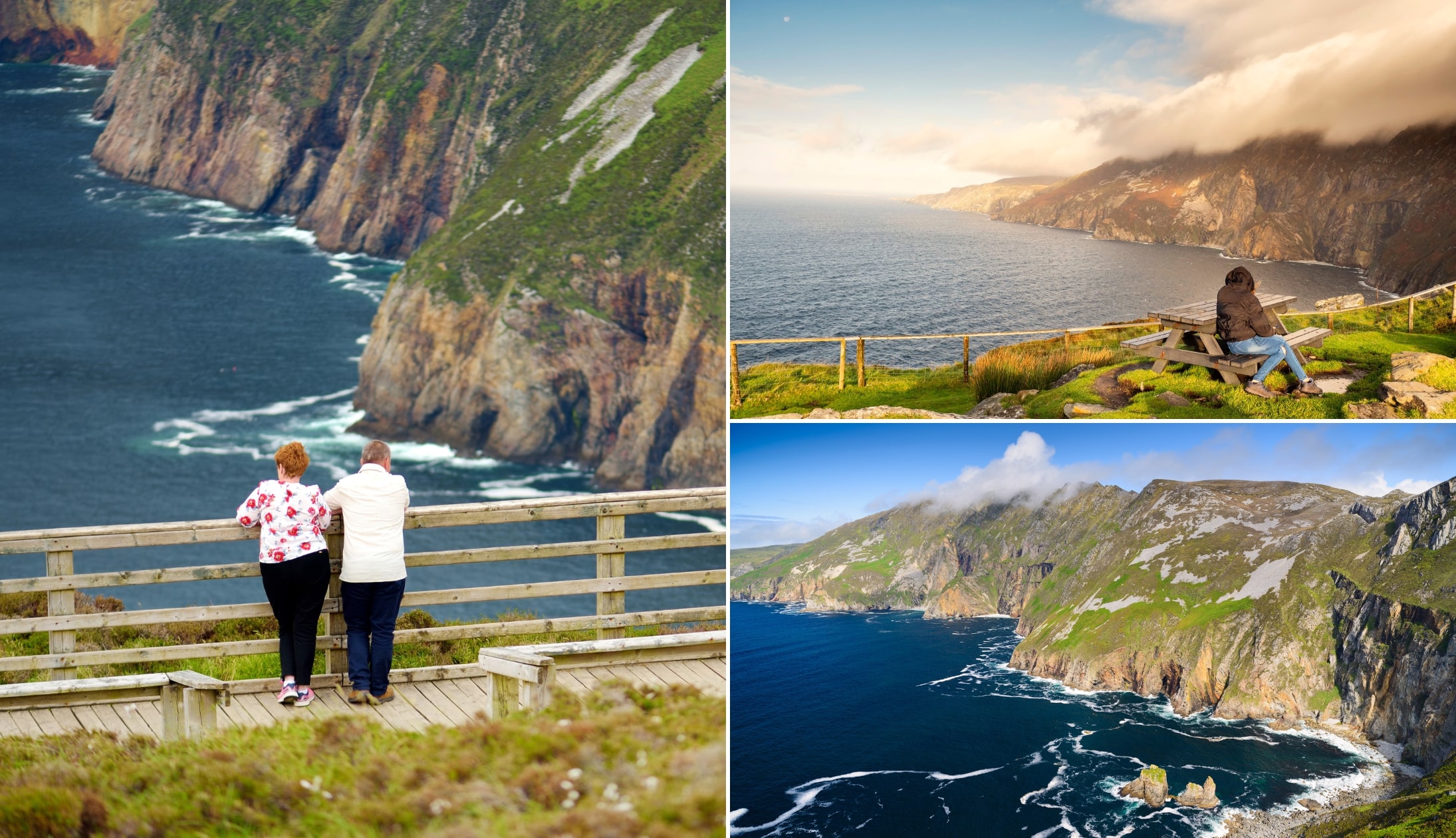
The Slieve League Cliffs in Donegal stand at an impressive 1,972 feet/601 meters.
They are nearly 3 times the height of the Cliffs of Moher and they’re almost twice the height of the Eiffel Tower.
Despite this, they’re still not the tallest in Ireland – that crown is held by Croaghaun on Achill.
Below, you’ll find a map of the Slieve League walks along with info on parking and the access restrictions during summer.
What to know before visiting the Slieve League Cliffs / Sliab Liag

A visit to the Sliabh Liag Cliffs was nice and handy up until recent years. But there’s new restrictions in place now that add a layer of complexity to a visit. Take 30 seconds to read the below:
1. Location
The Slieve League Cliffs (Sliabh Liag) are located on the south west coast of Donegal. They’re a 15-minute drive from Carrick, a 20-minute drive from Glencolmcille, a 30-minute drive from Killybegs and a 55-minute drive from Donegal Town.
2. The parking situation
Changes to the Slieve League parking situation has caused controversy in recent years. You now need to pay for the lower car park (€5 for 3 hours or €15 for the day). There are 2 places to park at the cliffs:
- Lower car park: Requires you to make a 30-minute+ moderately strenuous walk to the viewing point
- Upper car park: Beside the viewing platform. Anyone can drive up during off season, but only those with low mobility can drive up during peak
3. Shuttle bus and visitor centre
If you visit during the summer and you don’t want to walk up, you can park at the Slieve League Visitor Centre (here on Maps) and pay around €6 to take a shuttle bus to the top.
4. Weather and safety
The weather at the Slieve League Cliffs plays a huge part in your experience. It can get very misty here and, when it does, the entire view is obscured.
5. Safety
The Slieve League Cliffs are unfenced in the majority of places – never go near the edge. The drive from the lower to upper car park needs to be taken with care, as there are blind spots and a lot of people walk here.
Slieve League walk options
Photos via Shutterstock
There are several different Slieve League walk options, ranging from reasonably handy to long and strenuous.
Please take note of the warnings mentioned under each of the maps below.
1. The shorter (and most rewarding) walk

The first Slieve League walk is arguably the most popular as you get an eyeful of the cliffs from the moment you reach the viewing platform.
You can start the walk from either of the car parks (the walk up from the lower car park is fairly uneventful) and then stop at the Bunglass Point viewing area and drink in the scenery.
When you’re ready, you’ll follow a rough path upwards. To your left, the cliffs will come into view and remain with you for most of the climb.
While steep, it isn’t overly taxing. Please be aware that the wind is very powerful here, so PLEASE AVOID going near the edge.
2. The Pilgrim’s Path

The Pilgram’s Path is another popular Slieve League hike but it’s one that I amn’t a great fan of, personally.
The reason for this is that for the majority of the climb you’re facing the mountain while all of the scenery is hidden away.
Then, when you eventually reach the top, you don’t get to see the cliffs (you do, however, get a mighty view of Donegal Bay and beyond).
This version of the Slieve League walk is around 6km and takes 3 hours, depending on pace. It should never be attempted during poor visibility.
3. One Man’s Pass warning
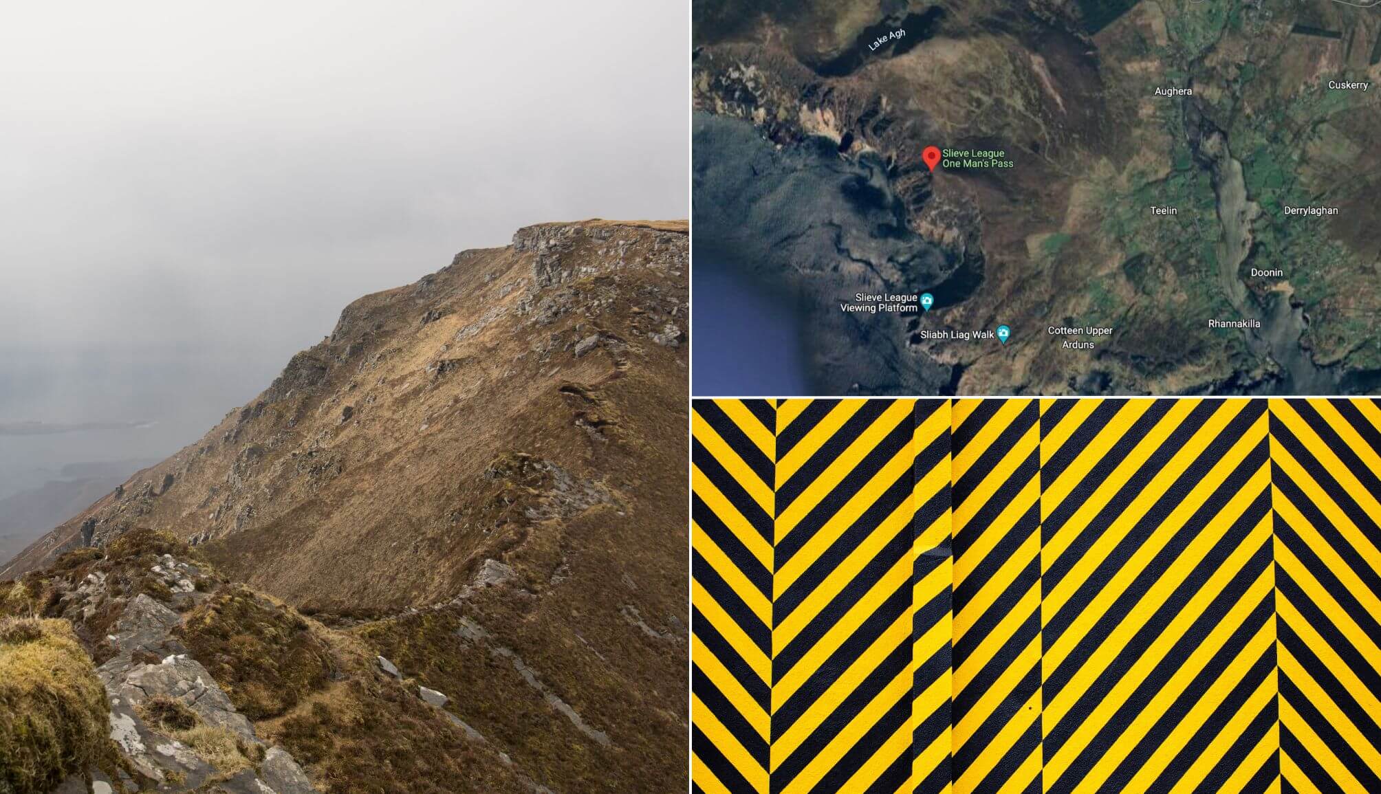
Photo left: GreenphotoKK. Bottom right: ModernAfflatus (both via Canva Pro)
There’s an extremely narrow pathway called ‘One Man’s Pass’ at Slieve League that should be avoided by all but experienced hikers.
And it should be avoided by everyone during bad weather or if you’re in any way bad with heights/are unsteady on your feet. This is dangerous.
One Man’s Pass is an extension to the Pilgrims’ Path.
This knife-edge like path is hundred of metres above the Atlantic below and poses a real risk to safety.
Things to see and do at the Sliabh Liag Cliffs
There’s a handful of things to see and do around the cliffs, from boat tours and ancient sites to the now-famous Éire sign.
Below, you’ll find some bits and bobs to do while you’re there. If you fancy a ramble, scroll up to my Slieve League walk section.
1. The Slieve League viewing platform

Photo © Tourism Ireland by Paul Lindsay
The viewpoint (Bunglass Point) is located right next to the upper Slieve League car park.
From here, you’ll be treated to views out across Donegal Bay all the way to Sligo and beyond.
While you’re stood here, keep an eye out for the little beach of pure white sand (only approachable by boat).
To the right hand side of the beach there’s a large cave where seals sometimes retreat to (don’t get too close to the edge when looking for this!).
2. The Éire sign and signal tower

Photo licensed from Lukassek
During the second world war, Ireland had certain agreements with The Allies.
One of these agreements allowed allied aircraft fly through the Donegal Corridor, a narrow strip of airspace that linked Lough Erne to the Atlantic Ocean.
The word Éire was placed in stone on headlands around Donegal (you can see another at Malin Head), to act as navigation aid for those flying above.
You can still see this Éire sign at the Sliabh Liag Cliffs – it’s situated right next to the viewing point car park.
You’ll also find an old signal tower at Carrigan Head that dates back to the Napoleonic wars.
3. The boat tour (highly recommended)

Photos courtesy Alan Hennigan via Fáilte Ireland
If you’re looking for unique things to do at the Sliabh Liag, climb aboard this boat tour (affiliate link) and see the Donegal coastline like never before from €33 per person.
The cruise leaves from nearby Killybegs and runs for just under 2 hours.
Over the course of the journey it takes in everything from the stunning Slieve League Cliffs to lighthouses, beaches and plenty more.
Places to visit nearby

One of the beauties of visiting the Sliabh Liag Cliffs is that they’re a handy spin of some of the best places to visit in Donegal.
I’d strongly recommend you follow the Slieve League Peninsula road trip outline in the map above. It’ll take you to:
- Donegal’s Secret Waterfall (20-minute drive): An incredible waterfall only accessible at certain times
- Silver Strand Beach (30-minute drive): One of Donegal’s most impressive beaches. Visit Maghera Caves and Beach further along the coast
- Glencolmcille Folk Village (20-minute drive): A replica of how villages in Ireland looked many years ago
- Assaranca Waterfall (40-minute drive): A spectacular sight that’s right next to the road
Keith O’Hara has lived in Ireland for 35 years and has spent much of the last 13 creating what is now The Irish Road Trip guide. Over the years, the website has published thousands of meticulously researched Ireland travel guides, welcoming 40 million+ visitors along the way. In 2022, the Irish Road Trip team published the world’s largest collection of Irish Road Trip itineraries. Keith lives in Dublin with his dog Toby and finds writing in the 3rd person minus craic altogether.
Devin
Wednesday 18th of June 2025
When you write "off-season" for parking, what months does that refer to? Other sites are vague. We're travelling mid September and curious if we can drive up to the top or not.
We've been using your site tons for planning our trip, so thanks very much!
Keith O'Hara
Thursday 19th of June 2025
Hey Devin! Mid-sept is what we call the 'Shoulder season' (the period between peak and off-season). I was at Slieve League in May (also shoulder season) and there was a council worker there stopping people driving up, so I'd say it would be the case for Sept also, but I may be wrong. The best thing to do is drive up, see if there's someone in a high-vis at the gate and, if so, drive back to the visitor centre and get the bus. If there isn't, happy days - open the gate, drive through, close the gate and head on up!
Nicole
Sunday 11th of September 2022
Hi, visited Slieve League this weekend; we parked in the free lot by the visitor center and took the shuttle, cost 5euro per adult. Shuttles run every 40 minutes. Hike was great on a clear sunny day, only mildly crowded. Thanks for your site for helping guide our trip!
bob
Friday 18th of August 2023
Yes your sight is very helpful. Waiting for my flight now to begin another journey.
Keith O'Hara
Wednesday 14th of September 2022
Hey Nicole! Glad you enjoyed the trip to Slieve League and thanks for the kind words!
Bernie McGarry
Wednesday 8th of September 2021
Hi, i was at slieve League today. You can't drive up to the upper car park anymore, unless maybe you had a wheelchair. You pay for parking now. There is a shuttle bus from the visitor centre that you come to before the lower car park. I don't know what the cost is as I didn't use it.
Allan Wilson
Monday 7th of September 2020
Is it possible to just drive then to the viewing point next to the second car park? That sounds like a fair trek from the 1st car park.
Keith O'Hara
Monday 7th of September 2020
Hi Allan - you can drive up to the viewing point (there's a little gate you'll need to open and close after the first car park).
I've heard people say that the road up to the viewing point is now in bits, so just be careful.