There are two versions of Sligo’s Queen Maeve Trail, both of which lead to the summit of Knocknarea Mountain, which stands at a height of 327 m (1,073 ft).
There’s the route from Strandhill, which reopened in early July of 2025 and there’s the trail from Primrose Grange.
Below, you’ll find a map for each version of the Knocknarea hike along with info on parking.
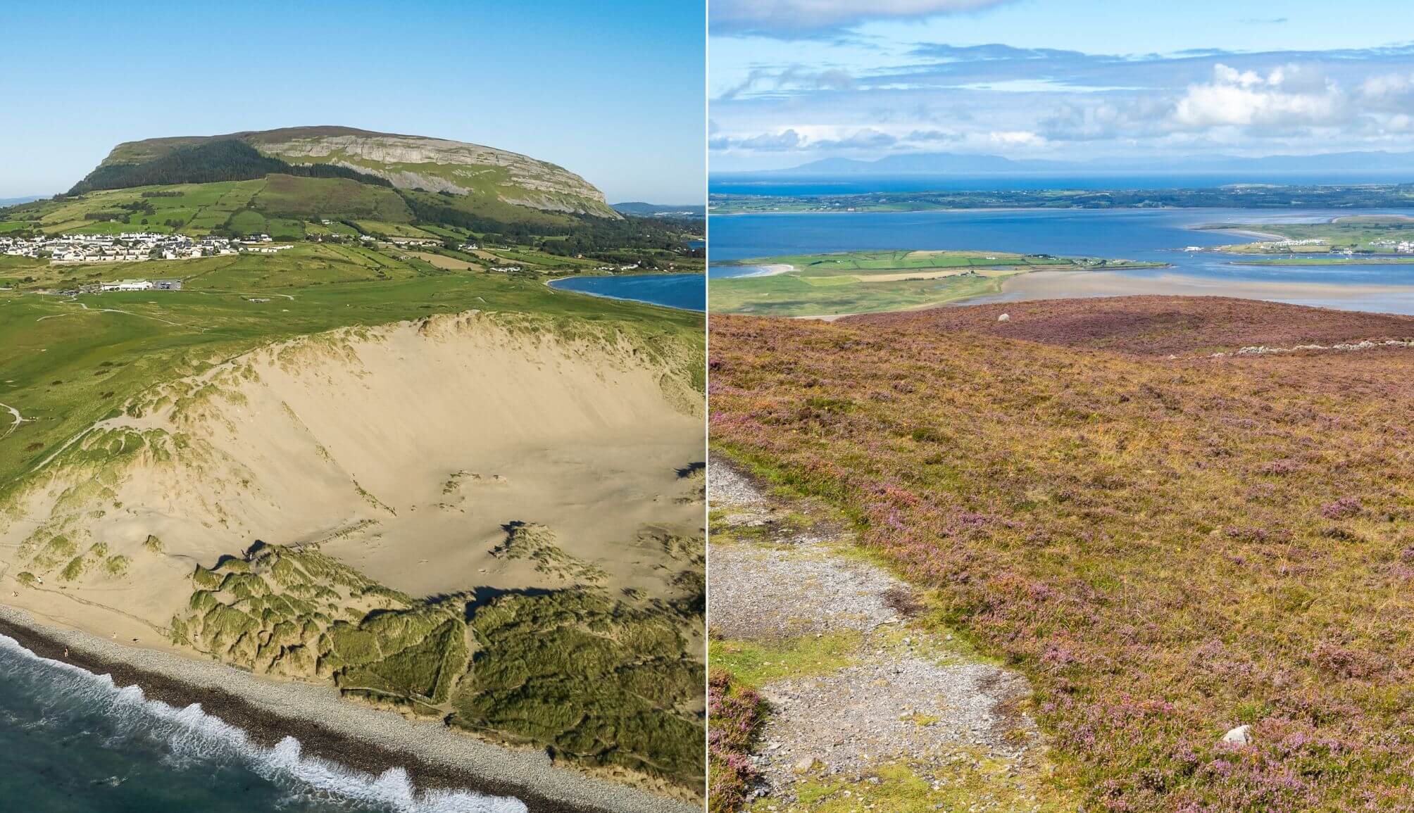
The Queen Maeve Trail up Knocknarea Mountain

Photos via Shutterstock
On a clear day, those that reach the summit of Knocknarea Mountain will be treated to views of Sligo, Leitrim and Donegal. Here’s some key information you need before you set off:
1. Two versions of the trail
So, you’ve decided to tackle the trail. The next thing you need to decide is which route you’ll go for (maps of both below):
- From Strandhill: Easy start-point for those without a car as it’s close to the town. There’s also a boardwalk through the forest
- From Primrose Grange: There’s a steep slog from the car park but views behind you towards Lough Gill for when you need a rest
2. Height and difficulty
Knocknarea stands at 327 metres (1,073 ft), with a moderately difficult trail that’s well trodden but steep on both sides.
3. How long you’ll need
The 6km linear trail typically takes 1.5 to 2 hours return. Allow extra time for breaks or soaking up the views at the summit.
4. Car park
There are several car parks for the Queen Maeve Trail, depending on which side you want to start from. If you are starting from Strandhill, you can park right across from the trail entrance in Sligo Rugby Club (make sure to stick €2 in the honesty box!). However, there’s also parking on the other side, right here.
5. The cairn
At the summit stands Queen Maeve’s Cairn, a 5,000-year-old Neolithic tomb where legend says the warrior queen of Connacht from Irish mythology is buried upright in full battle gear. The 55m-wide, 10m-high cairn is a protected National Monument, and climbing it is strictly forbidden.
The Knocknarea walk from Strandhill
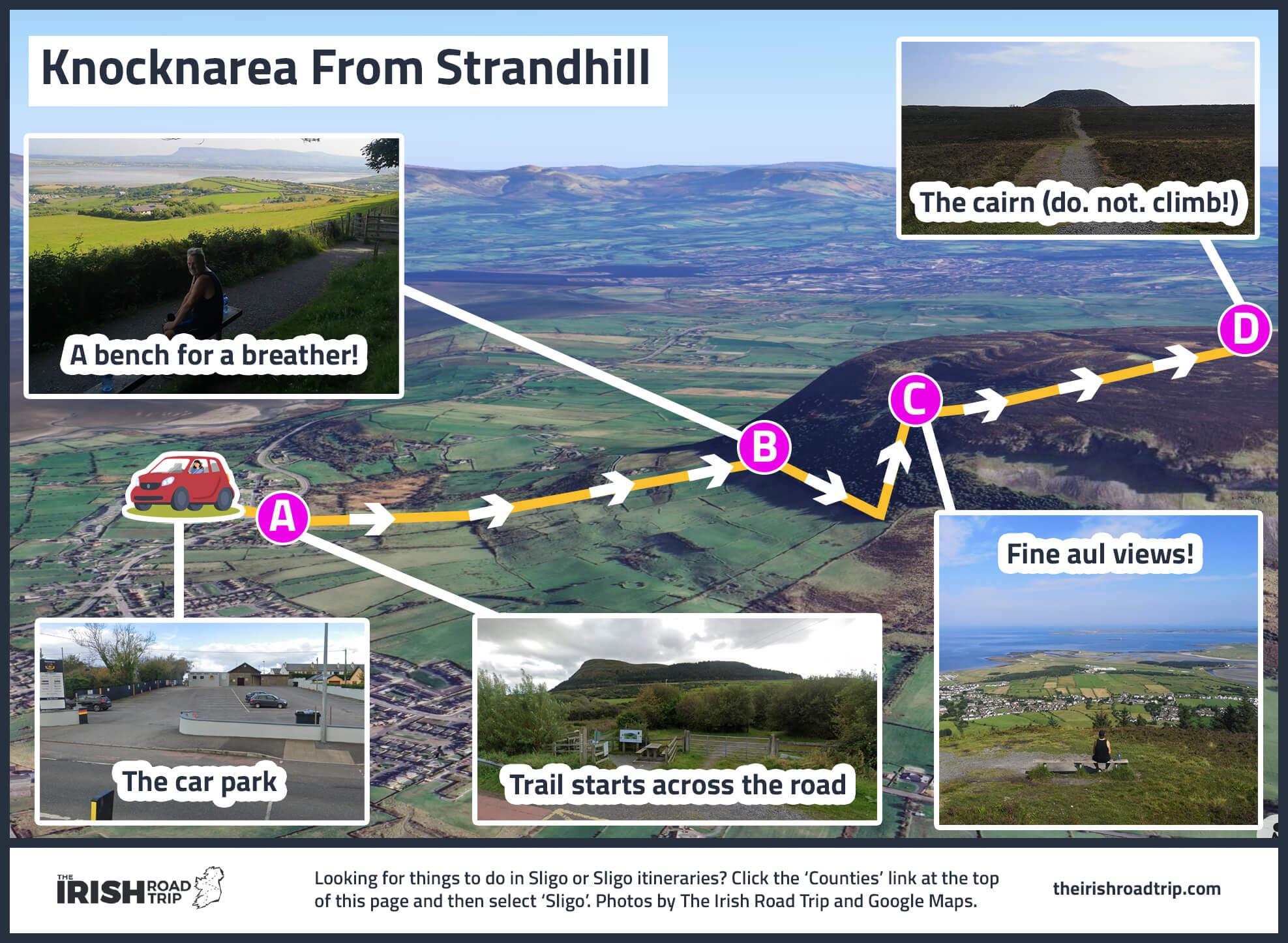
The more popular walk is the Queen Maeve Trail from Strandhill. As this is one of the more popular things to do in Sligo, the trail can get busy at weekends, so try and arrive early, if you can. Take a look over the map, first. Here’s a trail overview:
Starting the walk
Regardless of which of the car parks around Strandhill you park at, you’ll want to aim for Dolly’s Cottage – you can’t miss the trail head (here on Maps).
The first section of the Knocknarea walk is relatively uneventful, as you’ll walk through a field towards the base of the mountain.
Things get interesting when you start to make your way uphill along the base of the mountain, as the views out over Strandhill and Donegal Bay open up to your left.
The boardwalk
You’ll soon reach the recently refurbished boardwalk. From this point, the Knocknarea hike can be a bit of a challange as you’ve plenty of ground to cover before reaching level ground.
Keep going until you reach the clearing, where the summit comes into view. Take a moment to turn around and soak up the sweeping vista over Strandhill.
The summit of Knocknarea Mountain
Keep on going and the cairn will become visible, along with more glorious views. From this point, you can either retrace your steps or you can walk a little further to enjoy the views on the other side towards Sligo Town and beyond.
The Knocknarea hike from the opposite side

You can also tackle the Queen Maeve Trail from the opposite side of the mountain, from this car park at Primrose Grange.
Having done both versions of the Knocknarea walk, I wouldn’t rush back to this one as I found it tougher and less enjoyable overall compared to the Strandhill route.
I think this could have been partly psychological, as you’re pretty much straight into the incline from the get-go. With that said, you can take a breather and enjoy the views behind you if you need.
Things to do nearby

Below, you’ll find a handful of things to see and do after the Knocknarea walk, from food and more walks to beaches and much more
- A very hidden gem: The Glen is a hidden mossy chasm on Knocknarea’s side, formed naturally and alive with ferns, trickling water, and an otherworldly stillness
- Post-hike food: There are some great restaurants in Strandhill for a post-hike feed. You can ramble along Strandhill Beach after, too
- Lots more to do: Carrowmore Megalithic Cemetery (5-minute drive), Benbulben Forest walk (20-minute drive), Devil’s Chimney (25-minute drive), Glencar Waterfall (30-minute drive) and Gleniff Horseshoe Drive (40-minute drive)
Keith O’Hara has lived in Ireland for 35 years and has spent much of the last 13 creating what is now The Irish Road Trip guide. Over the years, the website has published thousands of meticulously researched Ireland travel guides, welcoming 40 million+ visitors along the way. In 2022, the Irish Road Trip team published the world’s largest collection of Irish Road Trip itineraries. Keith lives in Dublin with his dog Toby and finds writing in the 3rd person minus craic altogether.
Susan Labwot
Wednesday 15th of December 2021
Can I find public transport from the town to reach the mountain especially at this particular stand of the walk that you have recommended. Am planning my trip in two weeks and am excited about this outdoor
Keith O'Hara
Thursday 16th of December 2021
Hi Susan - do you mean from Sligo Town? Or Strandhill? If it's Sligo Town, there's a Rosses Point to Strandhill (via Sligo town centre) bus you can hop on.
Susan
Friday 27th of November 2020
Yes, I've climbed Knocknarea a good few times now. There's also a back way up to it. If you park in the Rugby club carpark & cross the road, there's a gravel pathway & then wooden steps up through the forest. It's a beautiful climb, especially done early morning to coincide with sunrise. Again, the reward is the stunning views & of course a coffee from Shell's afterwards enjoyed while watching the waves crash against the shoreline in Strandhill. Lovely article, thank you. Definitely hikes there for the to do list.
Matt
Sunday 5th of December 2021
@Susan, Is the walk 6km total? or 6km there and 6km back?