
Welcome to my tried-and-tested 11-day Wild Atlantic Way itinerary for 2026 and beyond.
I’ve spent the last 8 years mapping out Irish Road Trips for visitors to Ireland.
However, despite the fact that there are 800+ of them on this website, the Wild Atlantic Way road trip below is the most popular.
Here’s a quick overview:
- Day 1: Start in Kinsale and follow the coast to Bantry (Bantry for night 1)
- Day 2: The Ring of Beara (Killarney on nights 2 and 3)
- Day 3: The Ring of Kerry and Killarney
- Day 4: The Dingle Peninsula (Kilkee on night 4)
- Day 5: Loop Head and the Cliffs of Moher (Doolin on night 5)
- Day 6: Galway City and Connemara (Clifden on night 6)
- Day 7: Westport and Achill Island (Westport on night 7)
- Day 8: Sligo and Leitrim (Sligo on night 8)
- Day 9: The Slieve League Peninsula (Ardara on night 9)
- Day 10: North West Donegal (Letterkenny on nights 10 and 11)
- Day 11: The Inishowen 100 road trip
Key information about this Wild Atlantic Way itinerary

Why trust my guides? Here’s a tiny % of the feedback they receive!
Take 10 seconds to scan the points below, which explain the ins-and-outs of this road trip.
1. Where it starts
This Wild Atlantic Way itinerary begins in Kinsale Town but you could also start it in Donegal. Ideally, you want to start it from either Donegal or Cork in order to avoid having to double back on yourself.
If you aren’t able to start in the above locations, my Irish Road Trip library has itineraries that start from all major ferry terminals and airports in Ireland.
2. You’ll need a car
You’ll need to have your own car or be renting a car in Ireland for this itinerary.
If you don’t have a car, DON’T WORRY – I have hundreds of public transport itineraries in my Irish Road Trip library.
3. This is a ‘Fast-Trip’
This Wild Atlantic Way road trip moves quickly, packing as much in as is reasonably possible. The one downside of this is you move accommodation regularly, which won’t suit everyone.
If you prefer to explore at a SLOW PACE, I have ‘Slow-trips’ starting from Dublin, Shannon, Belfast, Cork, Wexford, Mayo and Donegal here.
4. Interactive map
At the end of this guide, you’ll find an interactive Wild Atlantic Way map that has all of the attractions, discovery points, towns, villages and more plotted!
Day 1. Kinsale to Bantry via the West Cork coast

This Wild Atlantic Way road trip kicks-off in the colourful little town of Kinsale in Cork.
You’ll explore Kinsale and then make your way along the West Cork coastline, stopping several times, before visiting Mizen Head.
You should try and start this day at 08:00 as you need to get to the final stop, Mizen Head, around 15:30.
Where to stay in Bantry on night 1
Any time I’m in Bantry I stay in The Maritime as:
- It’s right on the quay overlooking the water
- It’s a couple of minutes walk from pubs and restaurants
1. Kinsale Town

Kinsale is famous for its vibrant streets, but there’s much more to discover here if you know where to look!
Sure, the colourful facades and charming lanes steal the spotlight, but Kinsale brims with hidden gems.
My map above will give you a handy route to follow that takes in the best of the town over the course of 30 minutes.
2. The Scilly Walk
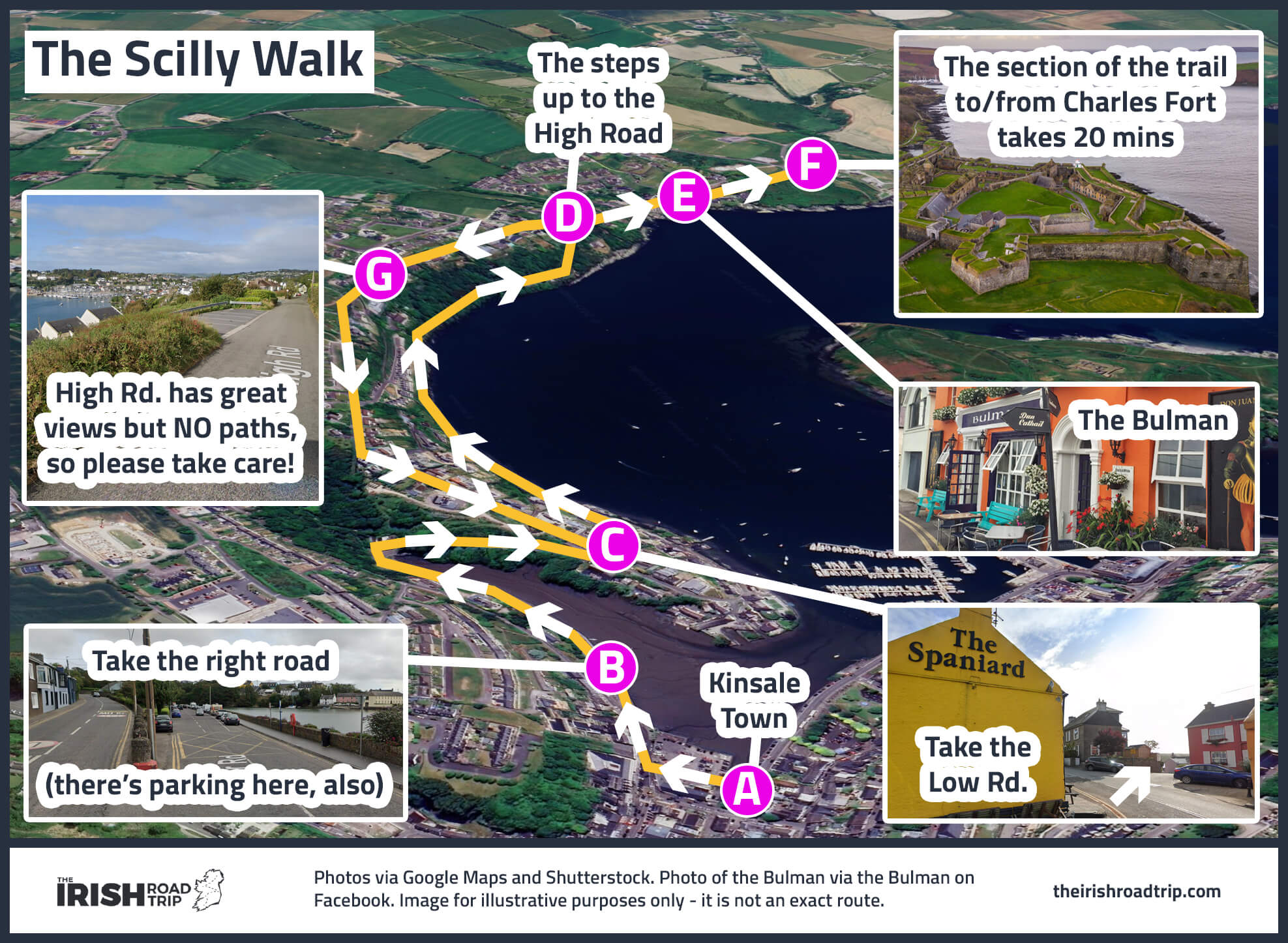
The Scilly Walk is a scenic 6 km trail offering stunning views of the harbour. It starts from the town and winds along the coast toward Charles Fort.
It’s a straightforward route that takes about 35 minutes each way, but you’ll want to take your time to soak up the views.
The trail offers a mix of coastal paths and gentle climbs, making it an enjoyable outing for walkers of all levels.
It ends at Charles Fort – a star-shaped 17th-century fortress offering panoramic harbour views and a glimpse into Ireland’s military history.
3. An early lunch
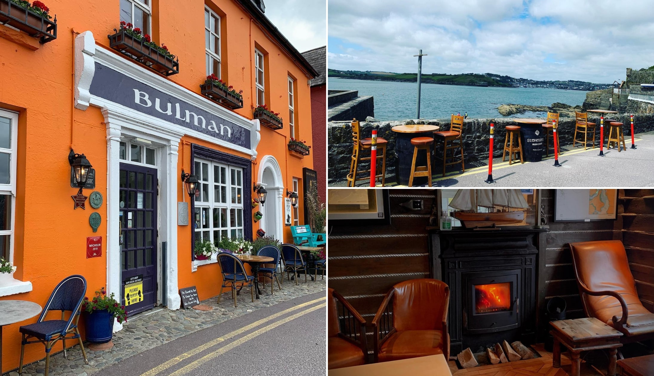
Photos via the Bullman on FB
You’ve a long day ahead, so it’s time for an early lunch.
You’ll have passed one of the best places to eat in Kinsale on the way to Charles Fort – the Bullman – but you’ll be dropping into it as you make your way back to town.
During the summer, the outside seats are like gold dust while, during the chiller months, the cosy seats by the fire are in high demand.
4. Inchydoney Beach

Photos via Shutterstock
Drive from Kinsale (compare car rental prices here) towards Clonakilty Town and then head down to Inchydoney Beach (50-minute drive).
Arguably one of the best beaches in Ireland, Inchydoney is known for its golden sands and pristine waters.
It’s around 1.5 km in length, so you can stretch your legs after the drive from Kinsale.
Need help with your itinerary? See my guide on how to plan a trip to Ireland the logical way!
5. Drombeg Stone Circle

Drombeg Stone Circle is a 25-minute drive from Inchydoney.
This ancient structure is aligned with the Winter Solstice sunrise and retains 13 of its original 17 standing stones.
Excavations in the late 1950s uncovered cremated bones carefully wrapped in thick cloth.
Close by are the remains of two prehistoric stone huts, thought to have been inhabited up until the 5th century.
6. The road to Mizen Head

The drive to Mizen Head is around 1 hour and 10 minutes, but there are plenty of places you can stop along the way.
You’ll pass through the scenic villages of Glandore and Union Hall, first.
The road then continues through Skibbereen (O’Neill Coffee is a great spot for a coffee and a baked treat!) before passing through Ballydehob and Schull.
The magic starts to happen when the brilliant Barleycove Beach meets your eye. You’ll then continue towards Mizen Head – the most southerly point in Ireland.
This will likely be the highlight for many taking this Wild Atlantic Way route, but PLEASE NOTE the opening hours – access to some paths is limited after 15:30.
7. Bantry for the night
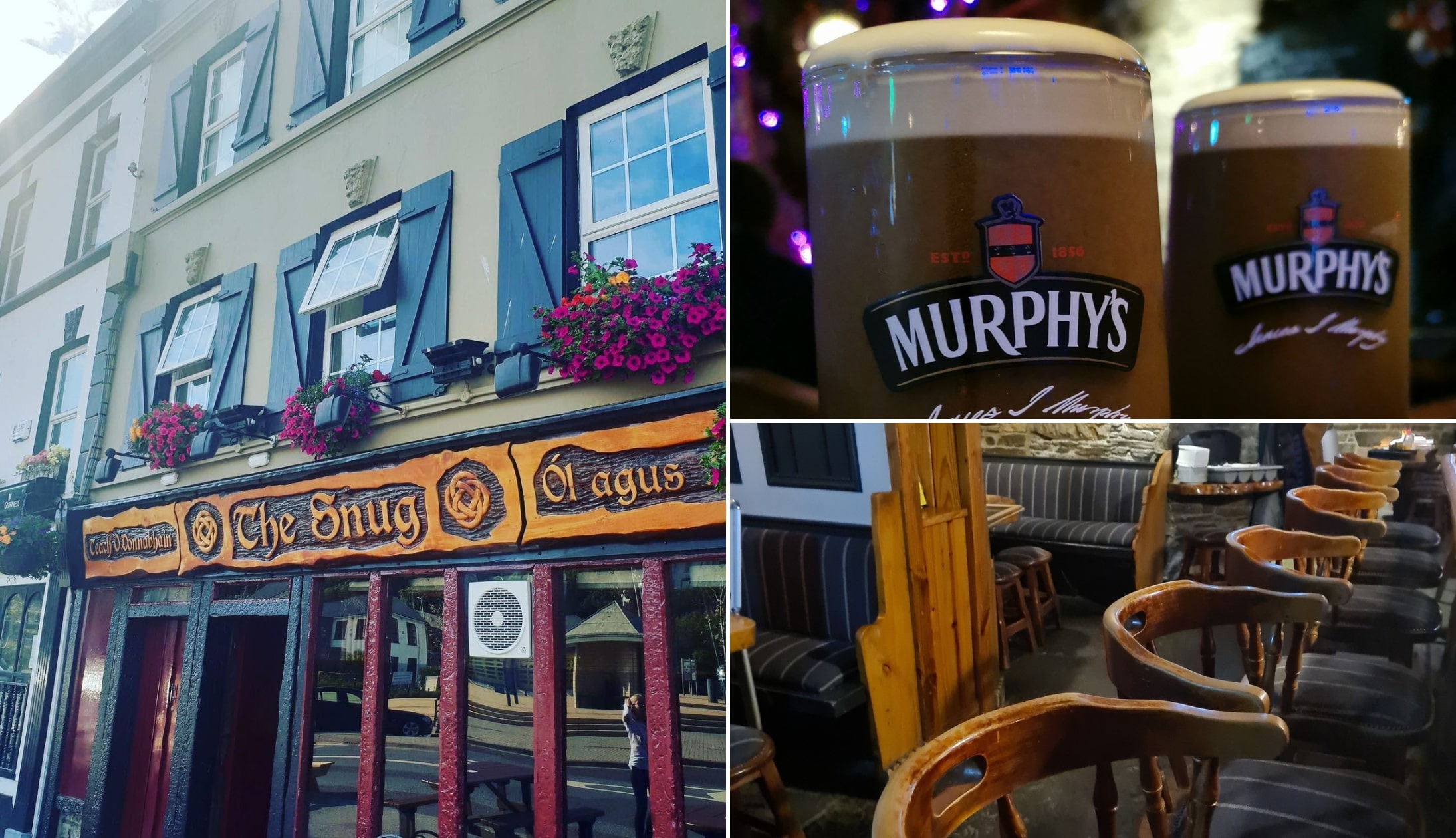
Photos via The Snug on FB
Day 1 of your Wild Atlantic Way road trip finishes after a 50-minute drive to Bantry Town.
Dinner recommendations
Bantry has lots of great places to eat, but my go-to’s are:
- The Snug: Hearty pub grub
- Fish Kitchen: Exceptional seafood
Live music and trad bars
- Ma Murphy’s: A fourth-generation Irish pub, full of charm with a lovely beer garden
- Anchor Tavern: an old-school Irish pub with traditional decor and a cosy atmosphere
Day 2. Bantry to Killarney via the Beara Peninsula

Day 2 of this Wild Atlantic Way itinerary sees you leave Bantry for Killarney, tackling the Ring of Beara on the way.
There’s much less driving today, you’ll be happy to hear!
Where to stay in Killarney on nights 2 and 3
- Budget: Kingdom Lodge (located right next to the National Park) and Castle Lodge (a cosy B&B just outside the town centre)
- Mid-range: Killaran House (highly rated and very central) and Killarney Avenue (located near the park)
- Luxury: Muckross Park (a 5-star retreat outside the town) and The Killarney Park (charming old-world style near the train station)
1. Glengarriff
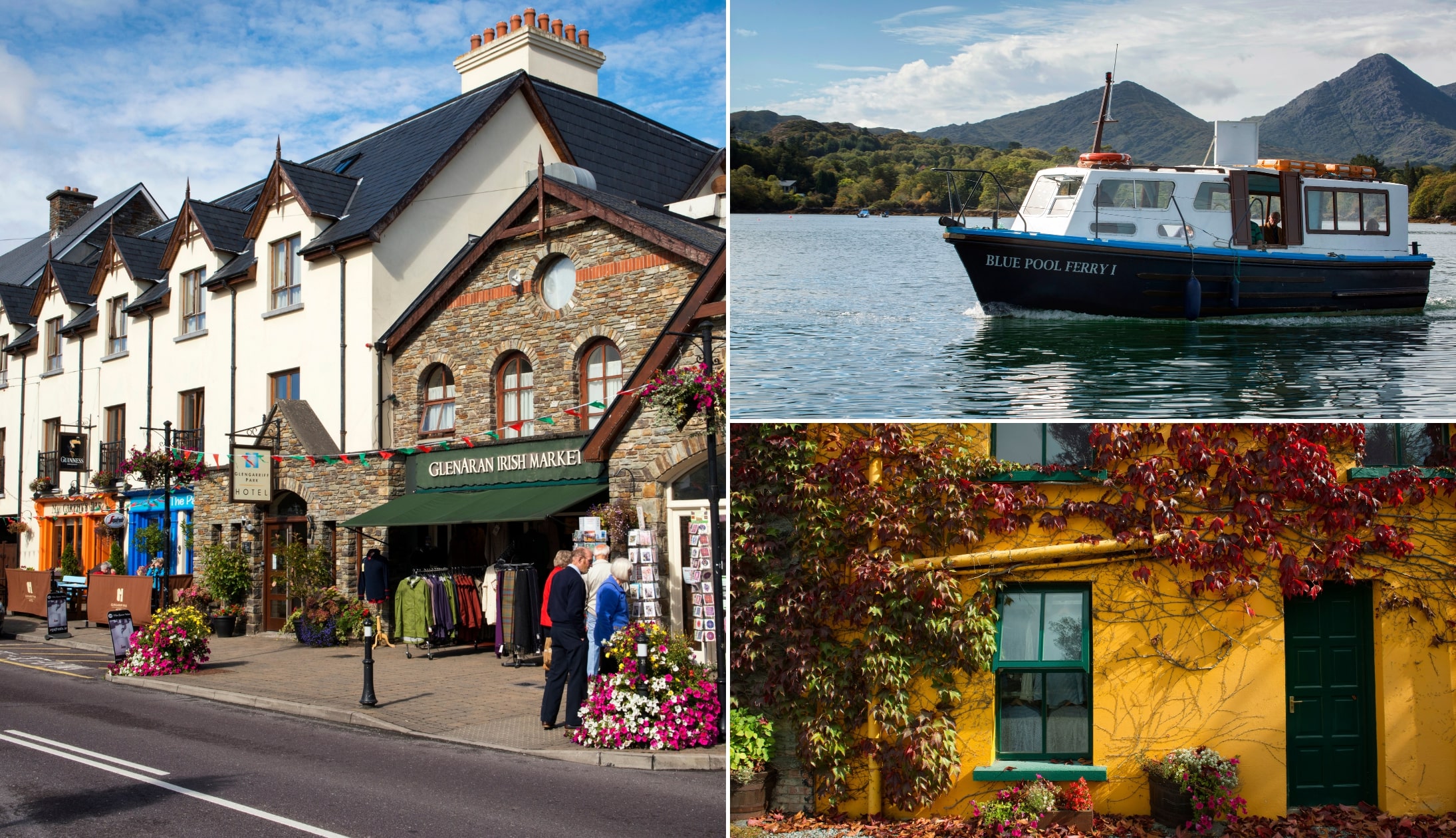
Photos via Shutterstock
Stop 1 of today is the little town of Glengarriff, 20 minutes from Bantry.
Park up and head to the Sugarloaf Cafe and grab a bit of breakfast/a coffee.
When you’re ready, walk 3 minutes to the Blue Pool – a natural harbour that’s tucked away behind trees and bushes.
You could also visit Garnish Island from the town. The ferry takes around 15 minutes and you’ll need 1 hour on the island.
2. Healy Pass

From Glengarriff, drive 20 minutes to Adrigole, where you can take the Healy Pass – one of the most unique roads in Ireland.
This winding route, constructed in 1847 as part of a Famine relief effort, is one of the bendiest roads in Ireland.
Along the way, you’ll find several pull-in spots, such as this one. Continue to the summit and pull in here.
To the right, there’s a hill. If you carefully climb it (a 5-minute effort), you’ll be rewarded with stunning views over Glanmire Lake.
Can’t decide what month to visit? See my guide to the best time to visit Ireland and the weather in Ireland by month!
3. The spin to Kenmare

You’ll need to double back on yourself after leave Healy Pass. When you reach the coast, follow the road clockwise.
Now, anyone who’s spent time on the Beara Peninsula will tell you that its X Factor lies in the scenery – it’s like stepping into an oil painting with breathtaking landscapes waiting around every corner.
The drive from the Healy Pass to Allihies takes about 50 minutes without stops, so plan for at least 1.5 hours to fully enjoy it.
One of the standout views on this Wild Atlantic Way itinerary is from this pull-in area, just before descending into the village.
4. Kenmare

When you arrive in Kenmare, park up and head for a ramble.
If you didn’t get lunch on the Beara Peninsula, there are great places to eat in Kenmare, including Davitt’s.
When your belly’s full, set off for a stroll – my map above outlines a good walking route that takes in the best of the town.
5. Killarney for the night

Day 2 of this Wild Atlantic Way itinerary finishes in the lively town of Killarney!
While there are plenty of things to do in Killarney, now’s the time to kick back and relax!
Here are some good food and pub recommendations:
- Restaurants in Killarney: Cronins, Porterhouse, and the Mad Monk are always a hit
- Pubs in Killarney: O’Connors and Jimmy Brien’s are two traditional pubs you’ll love
Day 3. The Ring of Kerry

Day 3 of this Wild Atlantic Way route is likely to be the most memorable for many of you.
Today, you’ll be following my 1 day Ring of Kerry itinerary that also takes in the mighty Skellig Ring.
You’ll be staying in Killarney again this evening, so no need to worry about moving accommodation.
1. The Ring of Kerry

I’ve got a tried-and-tested (I’ve done it many times) Ring of Kerry route that I outline in the map above.
Rather than going into all the stops in detail (you can find that here), here’s a quick overview.
This itinerary starts with the best of Killarney National Park, before continuing along the N70 road:
- Stop 1: Ross Castle: Perched on the edge of Lough Leane for over 500 years
- Stop 2: Muckross Abbey: Stunning ruins dating back to 1448
- Stop 3: Torc Waterfall: A 66 ft high waterfall just 5 minutes from the car park
- Stop 4: Ladies View: A breathtaking viewpoint.
- Stop 5: Moll’s Gap: A scenic mountain pass with incredible views of the MacGillycuddy’s Reeks
- Stop 6: Kenmare: You’ll have visited here yesterday, so you can leave it out
- Stop 7: Staigue Stone Fort: An ancient fort dating back to 300–400 AD
- Stop 8: Caherdaniel: Stop for lunch at the Blind Piper
- Stop 9: Derrynane Beach: One of Ireland’s most beautiful beaches
- Stop 10: Coomakista Viewpoint: Enjoy stunning views of Deenish and Scariff Islands
- Stop 11: Coomanaspig: A lofty viewpoint accessible by car
- Stop 12: Kerry Cliffs: Towering 1,000 ft-high cliffs that will leave you speechless.
- Stop 13: Valentia Island: Visit the Geokaun Viewpoint for jaw-dropping scenery.
- Stop 14: Dinner in Portmagee
- Stop 15: Return to Killarney for the night
Day 4. Killarney to Kilkee via Dingle

Day 4 of this Wild Atlantic Way guide sees you leave Killarney, explore the Dingle Peninsula and then head for Kilkee where you’ll spend the night.
There’s quite a bit of driving today, but it’s broken up with plenty of stops along the way.
Where to stay in Kilkee on night 4
Any time I stay in Kilkee, I stay in the Bay View Hotel as:
- It tends to be good value
- The rooms are clean and comfortable
- It’s a short walk from everything (including the beach)
1. The Dingle Peninsula

You’re going to be following the Dingle Peninsula Drive today, as outlined on my map above.
This is arguably one of the best road trip routes in Ireland, so you’re in for a treat.
2. Inch Beach

Inch Beach is a 45-minute drive from Killarney and it kicks-off day 4 of your Wild Atlantic Way road trip.
Inch is actually a little peninsula, as you’ll see from the map above.
While I call it ‘little,’ it stretches an impressive 5.5km out into the water.
Take a stroll along the sands of Inch, and you’ll spot both locals and visitors testing their skills against the waves (some more successfully than others)!
3. Minard Castle

One of the often-overlooked gems on the Dingle Peninsula Loop is just a quick 15-minute drive from Inch – Minard Castle and Beach.
The drive up is fairly straightforward, though you’ll be navigating narrow country roads often shared with farming vehicles.
Fans of classic cinema might recognise the castle from the 1970s film ‘Ryan’s Daughter,’ where it was referred to as ‘The Tower.’
4. The Slea Head Drive

Leave Minard and pass through Dingle Town (don’t worry – you’ll visit it later on).
You’re about a 20-minute drive from the start of the Slea Head Drive, a 38km (24-mile) route showcasing many of the top attractions in Dingle.
Here’s a quick guide to the highlights along the way:
- Ventry Beach: A 4.5km Blue Flag beach
- Ceann Sleibhe and the White Cross: Two incredible viewpoints
- Radharc na mBlascaoidí: Panoramic views of Dunmore Head
- Coumeenoole Beach: A breathtaking beach with strong rip tides
- Dun Chaoin Pier: Launch point for the Blasket Island Ferry
- Ceann Sraithe: A famous Star Wars filming spot
- Clogher Strand: One of Kerry’s most beautiful beaches
5. Dingle Town for lunch and a stroll

The Slea Head Drive will take you back into Dingle Town (there’s parking available near the harbour).
You’ll find plenty of excellent restaurants in Dingle (Fish Box is a personal favourite!) and countless old-school pubs to enjoy.
When you’ve had a good feed, head for a ramble around the town via the route outlined in my map.
6. Conor Pass

When you leave Dingle Town, take the 15-minute drive up to Conor Pass.
Conor Pass is one of Ireland’s highest mountain passes, and it’s not for the faint-hearted, especially if you’re a nervous driver.
Thankfully, you don’t have to tackle the full drive. Coming from the Dingle side, you’ll reach a car park before the road narrows.
From here, you can take in sweeping views of the valley below and watch cars wind their way through the challenging bends from a safe distance.
7. Take the Tarbert Ferry to Clare

Courtesy Valerie O’Sullivan for Fáilte Ireland
The Tarbert Ferry is a 1.5-hour drive from the last stop and its from here that you’ll take the 20-minute crossing to the Loop Head Peninsula.
Now, my only issue with the Tarbert Ferry is that you can’t actually book a crossing time – you book an open ticket.
The result, and this has happened to me in the past, is that you can arrive to the terminal and have to wait for a while.
However, this is a nice and unique way to see the Atlantic coast and it’ll save you having to drive all the way around.
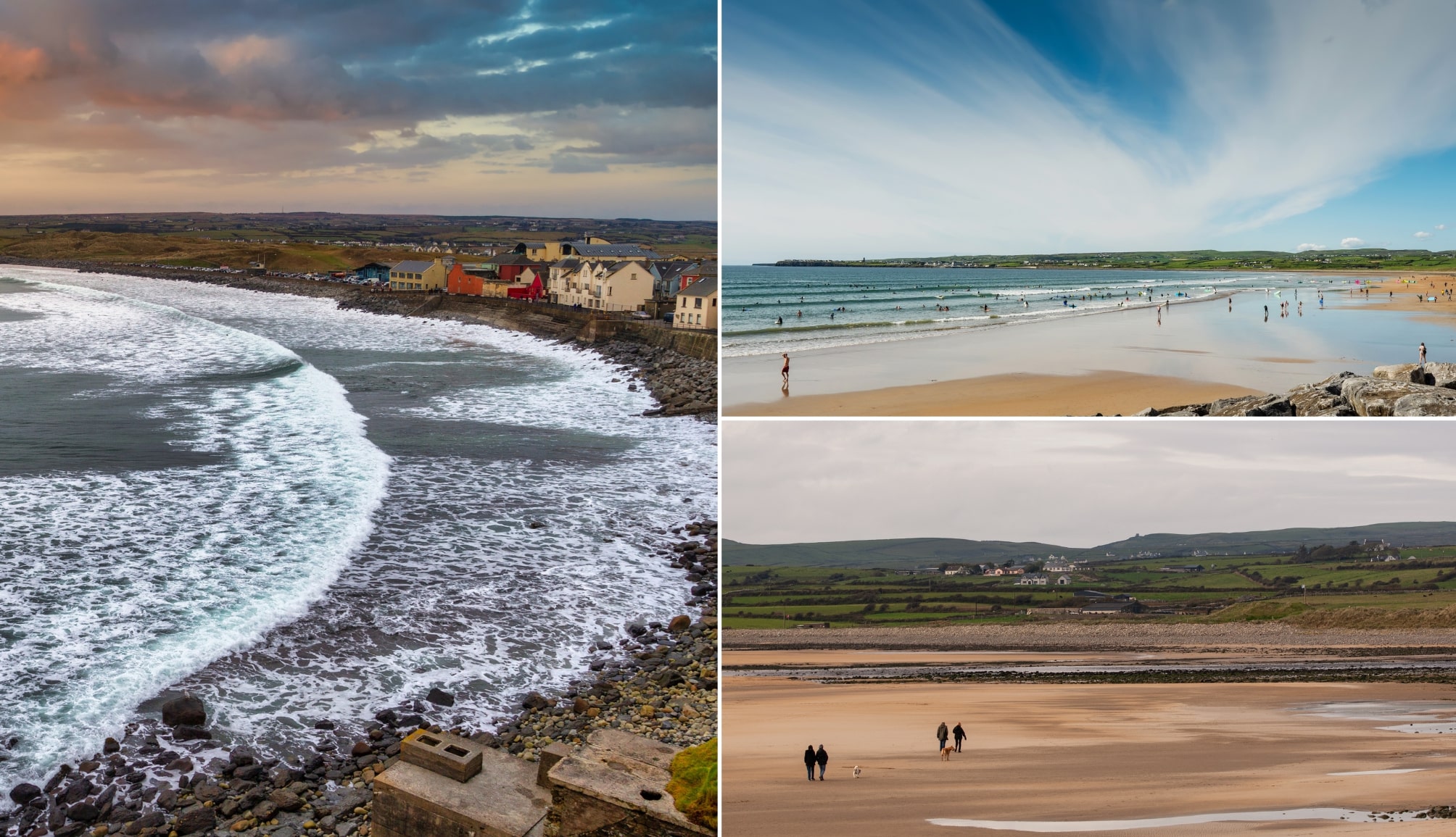
8. Kilkee for the evening

Photos via Shutterstock
Kilkee is a 25-minute drive from the ferry terminal. This is a seaside town that grew in popularity in Victorian times.
It’s a horse-shoe shaped bay, its entrance protected by a reef known as the Duggerna Rocks.
While very busy during summer, it can be like a ghost town during the winter months.
- Food: The Pier Restaurant in the Bayview or Nolan Fish and Chips for something more casual
- Pubs: Scott’s (a very traditional pub on Main St.)
Day 5. The Clare Coast to Doolin

Day 5 of this Wild Atlantic Way guide sees you explore Loop Head before heading to Doolin.
There isn’t a whole lot of driving today, you’ll be happy to hear!
Where to stay in Doolin on night 5
- Central stays: West Haven House (a short walk to McDermott’s Pub) and Cullinan’s Guesthouse (across from Fitzpatrick’s Bar)
- Our favourites: Doolin Inn (steps from Fisher Street), Fiddle + Bow Hotel (boutique-style and very central), and Hotel Doolin (good value and central)
1. The Loop Head road trip

You’re going to kick off day 5 with a road trip around the Loop Head Peninsula.
The total drive time is around 30 minutes out to Loop Head and then 30 minutes back.
- Stop 1: Kilkee Cliffs (there are several versions of the Kilkee Cliff Walk, ranging from short to long)
- Stop 2: The Bridges of Ross (sea arches that you can walk across)
- Stop 3: Loop Head Lighthouse (you’ll see the Cliffs of Campoy from just past the car park)
2. Lunch in Lahinch
Photos via Shutterstock
When you finish up at Loop Head, take the 1 hour and 10-minute drive along the coast to Lahinch.
There are plenty of optional stops along the way, including Spanish Point and Miltown Malbay.
Lahinch is lively seaside town that’s arguably best-know as a haven for surfers the country over.
For lunch, or even just for a coffee and a baked treat, head into Dodi Cafe and then saunter along the sand.
3. The Cliffs of Moher

Your next stop is the magnificent Cliffs of Moher – the most popular of the many things to do in Ireland.
Just a 15-minute drive from Lahinch, these cliffs offer breathtaking views of the wild Atlantic, Galway Bay, and the Aran Islands.
On-site, you’ll find a visitor centre, 800 metres of paved walkways with various viewing areas, and the historic O’Brien’s Tower.
In my opinion, the visitor centre isn’t particularly special, but with the Cliffs of Moher Experience, you’ll get access to all three.
4. Explore around Doolin

There are plenty of things to do in Doolin, a 15-minute drive from Moher.
Two of the highlights are Doonagore Castle and Doolin Cave.
Doonagore Castle is a privately owned 16th-century tower house near Fisher Street. There’s mighty views but very limited space to pull-in.
Doolin Cave, home to Europe’s longest free-hanging stalactite, offers a 45-minute guided tour showcasing its 70,000-year-old natural wonder and surrounding farmland trail.
5. Doolin for the night

Night 4 of this Wild Atlantic Way road trip ends in Doolin – a 1 hour and 20 minute drive from Adare.
- Restaurants in Doolin: Enjoy modern Irish cuisine at Anthony’s or savour local seafood at Russell’s Seafood Bar
- Pubs in Doolin: There are 4 main pubs in Doolin (as shown on my map above). You’ll likely end up at the ones closest to your accommodation, as they’re quite spread out
Night 5 of this Wild Atlantic Way itinerary finishes in Doolin once again.
Head back to your accommodation to chill for a bit and then grab a bite-to-eat.
If you fancy some live music, Gus O’Connor’s on Fisher Street rarely disappoints.
Day 6. Doolin to Connemara

Day 6 of this Wild Atlantic Way route takes you from Doolin, up along the Clare coast, through the Burren and into Galway City.
You’ll explore the city and then head off into Connemara, where you’ll spend the night in Clifden.
Where to stay in Clifden on night 6
- Budget: Errismore House is right in the town and always great value
- Mid-range: Alcock & Brown Hotel is in the town and has excellent reviews
- Unique: Abbeyglen Castle is good value a short walk from the town
1. The Burren Scenic Drive

A chunk of the drive from Doolin to Galway is a scenic one.
The map above show the Burren Scenic Drive which takes in many of the best things to do in Clare.
You can do this entire route, if you fancy, or you can peel off at Ballyvaughan and take the N67 towards Galway City.
2. Dunguaire Castle

Dunguaire Castle is located a 35-minute drive from Galway and dates back to 1520 when it was built by the O’Hynes clan.
In 1912, the castle was purchased by writer Oliver St. John Gogarty, who restored it and hosted literary greats like W.B. Yeats and George Bernard Shaw.
It’s among the most breathtakingly situated castles in Ireland, thanks to it’s position on the shores of Galway Bay.
Local legend has it that if you stand at the front gate and ask a question, you’ll receive your answer by the end of the day!
3. Galway City

When you arrive in the city, it’s time to grab parking. There’s plenty of car parks around, but I tend to park in Q-Park Hynes Yard.
It’s time for a feed – there are heaps of brilliant places for lunch in Galway, but Blakes Bar (pub grub) and Zappis (Italian) are both worth considering.
When you’re ready, it’s time to explore and, luckily enough, Galway is a very walkable city.
I’ve prepared a self-guided Galway walking tour for your to follow along with the map above.
4. The drive through Connemara

It’s roughly 75 minutes from the city to Clifden along the N59.
Although I’ve outlined the short route in the map above, there are longer routes, too.
I’ve outlined both of these routes in my Galway to Connemara road trip guide.
You’ll pass through the traditional village of Oughterard, then onwards to Maam Cross, passing by mountains, lakes, and moorland.
Once you’ve arrived in Clifden, make a quick stop to stretch your legs and grab a coffee before continuing onto the Sky Road. I’d recommend the Upstairs Downstairs Cafe or The Blooming Gorse.
5. Kylemore Abbey
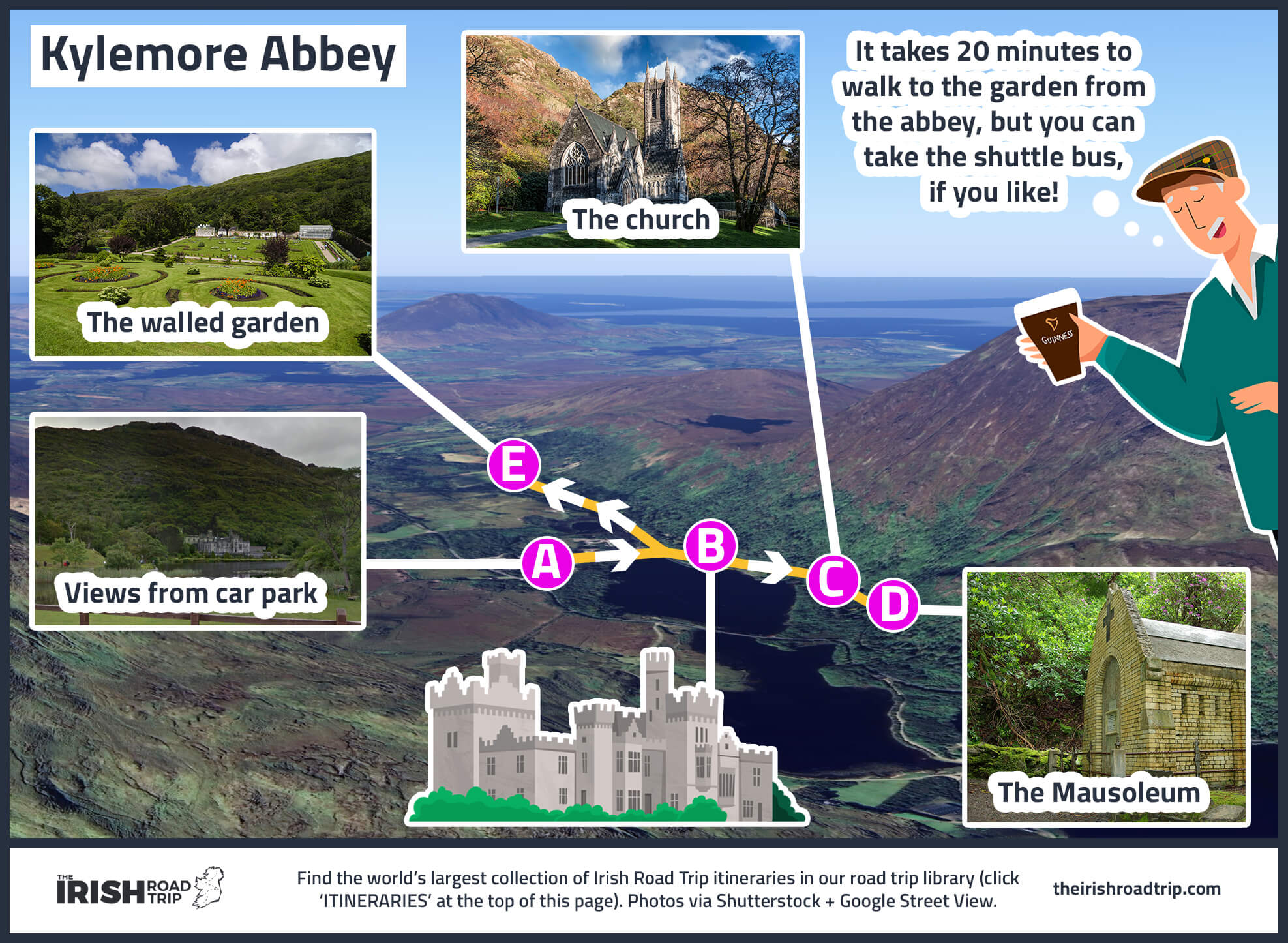
It’s a short 9-minute drive to Kylemore Abbey, arguably one of the most popular places to visit in Galway.
Kylemore Abbey is a stunning Benedictine monastery that dates back to the 1920s. It’s incredibly picturesque, sitting on the shores of Pollacapall Lough.
The lower floors of the abbey have been restored and are open to the public, as well as the beautiful Victorian Walled Garden.
The estate includes a Neo-Gothic church and several woodland and lake-side walks.
6. The Sky Road

Your final stop of the day is the Sky Road, which is one of the most rewarding drives on this Wild Atlantic Way route.
This is a breathtaking 16km loop that begins in Clifden, making its way around the Kingston peninsula along a coastal road with stunning views.
Along the way, the loop passes by Clifden Castle, a ruined manor house overlooking the water.
After the castle, the Sky Road deviates into two routes which join up again later, the lower road which has close-up views of the sea, and the upper road, which has views over the bay.
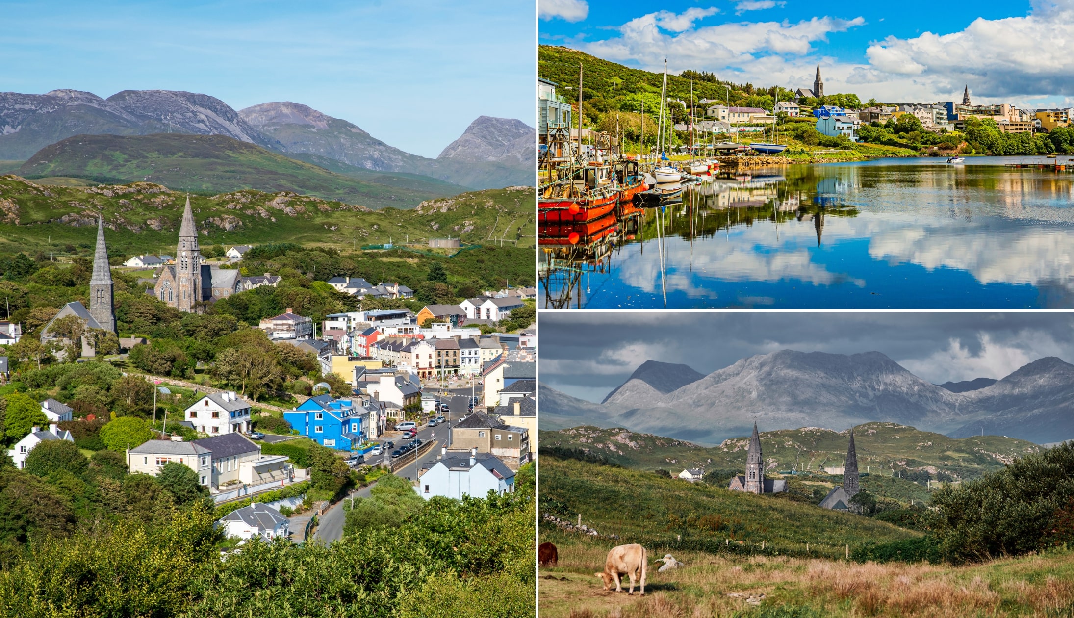
7. Clifden for the night
Photos via Shutterstock
Night 6 of your Wild Atlantic Way road trip finishes in Clifden Town.
This is a lively tourist town during the summer months but it tends to be much quieter outside of peak season.
- Places to eat: Guys Seafood Bar and Off The Square
- Pubs: Lowry’s Music & Whiskey Bar and McGraths Pub
Day 7. Clifden to Achill Island via Westport

Day 7 of this Wild Atlantic Way itinerary sees you take the spin from Galway into Mayo.
You’ll travel through the Doolough Valley, explore Westport and then head onto Achill Island for the night.
Where to stay on Achill on night 7
Personally, I think Stella Maris Luxury Bed and Breakfast is the best place to stay on Achill, because:
- It’s located right across from the cliffs at Keel and the views are mighty
- The standard of accommodation is excellent
- It’s a short walk to the The Amethyst Bar
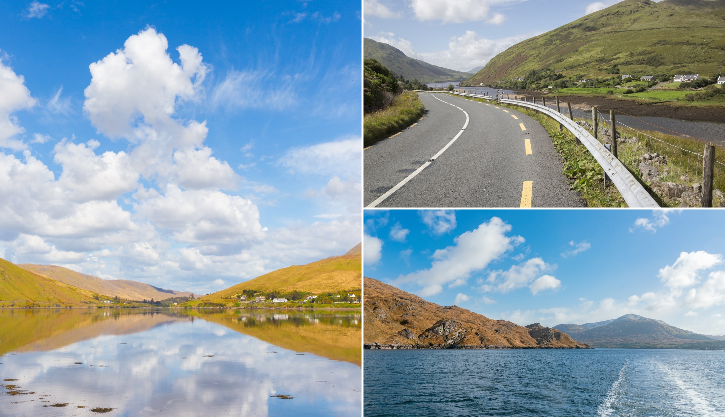
1. Killary Fjord
Photos via Shutterstock
Your first stop of the day is this viewpoint, a handy 35-minute drive from Clifden.
It’s here that you’ll be treated to stunning views of Killary Harbour (Ireland’s only fjord).
If you look hard enough, you may be able to spot the potato mounds across the fjord, which date back to the famine.
From here, follow the road in Leenane – one of the most charming small towns in Ireland.
2. Aasleagh Falls

Aasleagh Falls is less than 10 minutes from Leenane,
There are two car parks at the falls, and it’s just a short walk to the cascade.
However, with no official path to the waterfall, be prepared to cross a mucky field.
It’s a gorgeous cascade, especially after the rain, and it’s a fine place to relax a little while, contemplating the meaning of life as the tranquil sound of running water fills the air.
3. Doolough Valley

After you leave the falls, you’ll be making your way to Louisburgh via the outstanding Doolough Valley.
This stretch of road is one of the most scenic drives in Ireland, and you’ll often find the place virtually empty.
The Doolough (‘Black Lake’ in English) Valley is a scenic corner of Mayo where unspoiled scenery collides with raw, isolated beauty.
4. Westport
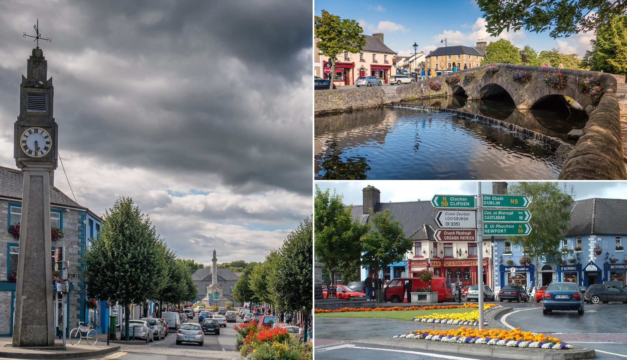
Photos via Shutterstock
Westport is a 30-minute spin from Louisburgh.
This is a charming town that’s perfect for a leisurely stroll – I’ve put together this route you can follow that covers many of Westport’s main landmarks.
The route is around 1.3km long, takes about 20 minutes, and gives you a great overview of the town. Here’s what you’ll see:
- Stop 1 (coffee): Start at This Must Be The Place for a coffee
- Stop 2 (The Clock): Built in 1947, this is Ireland’s only art-deco municipal clock. It’s nicknamed ‘The Four Faced Liar’ for often showing the wrong time
- Stop 3 (The Octagon): Westport’s most iconic landmark, built between 1843 and 1845, featuring St. Patrick at the top of the column
- Stop 4 (Doris Brothers’ Bridge): A stunning stone bridge
- Stop 5 (The Mall): Walk along the river past St. Mary’s Church
- Stop 6 (Bridge St): End your route among the colourful buildings of Bridge Street
5. The Atlantic Drive

You’re going to be tackling the Atlantic Drive on Achill Island, next.
The first stop, Mulranny Beach, is a 30-minute drive from Westport. Here are the stops:
- Mulranny Beach: Enjoy the Mulranny Causeway Walk
- Dumhach Bheag: Slightly elevated viewpoint offering panoramic views across Clew Bay
- Spanish Armada Viewpoint: Scenic spot overlooking Clare Island, where five ships from the Spanish Armada ran aground
- Grace O’Malley’s Towerhouse: A 15th-century tower once used by Grace O’Malley, the Celtic Goddess
- Cloughmore Viewpoint: A rocky, scenic viewpoint overlooking Achillbeg Island
- White Cliffs of Ashleam: A dramatic Wild Atlantic Way Discovery Point featuring jagged cliffs battered by the waves
- Dooega Bay Beach: A peaceful, less-crowded beach with soft sands, rock pools, and stunning views
- Minaun Heights: A 466m-high viewpoint offering one of the best panoramic views on this Wild Atlantic Way route
- Keel Beach: A vast sandy beach perfect for surfing, kayaking, and coastal walks
- Keem Beach: Iconic golden-sand beach surrounded by green hills
- Golden Strand: A crescent-shaped sandy beach in Dugort
- Achill for the night: Take it handy
Day 8: Achill to Sligo and Leitrim

Day 8 of this Wild Atlantic Way route takes you from Achill to Sligo.
There’s very little driving today after the initial 2 hour drive over to the Caves of Keash.
Where to stay in Sligo on night 8
- Budget: Station Lodge (good value and nice and central)
- Medium: Clayton Hotel (short walk to town and it has a leisure centre)
- Highish: The Address (boutique hotel at the heart of the action)
1. The Caves of Keash
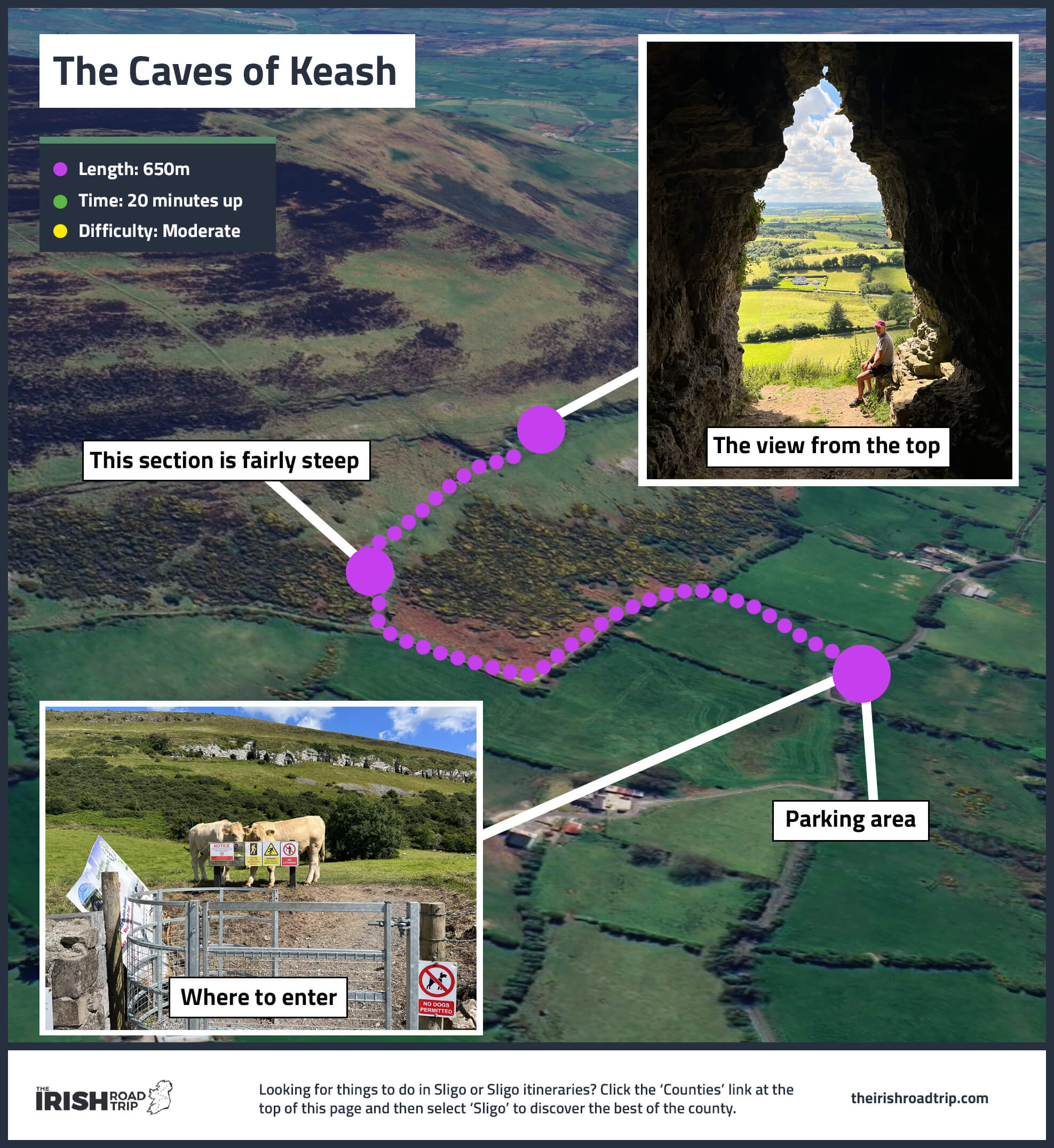
The first stop of the day is a 2-hour drive from Achill – the Caves of Keash.
The trail up to see the Caves of Keash is steep, but at just 650m/20 minutes, it’s a very rewarding walk.
The caves form an ancient passage tomb cluster believed to predate the Pyramids of Egypt by 500-800 years!
When you reach the caves, you’ll be treated to a magnificent view out over the surrounding countryside.
3. Lunch and a ramble in Sligo Town
Photos via Shutterstock
Sligo Town is a 25-minute spin from the caves.
When you arrive, check in to your accommodation and then head out into the town.
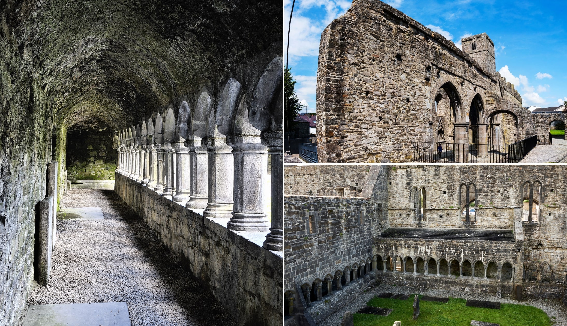
Sligo Abbey, founded in 1253 by Maurice Fitzgerald, is arguably its main attraction.
This timeless relic has withstood centuries, from its construction during the height of Norman influence to the devastating fire of 1414, leaving behind its hauntingly beautiful ruins.
When you’re ready, it’s time for a feed. There are some great places to eat in the town, but Hooked is hard to beat.
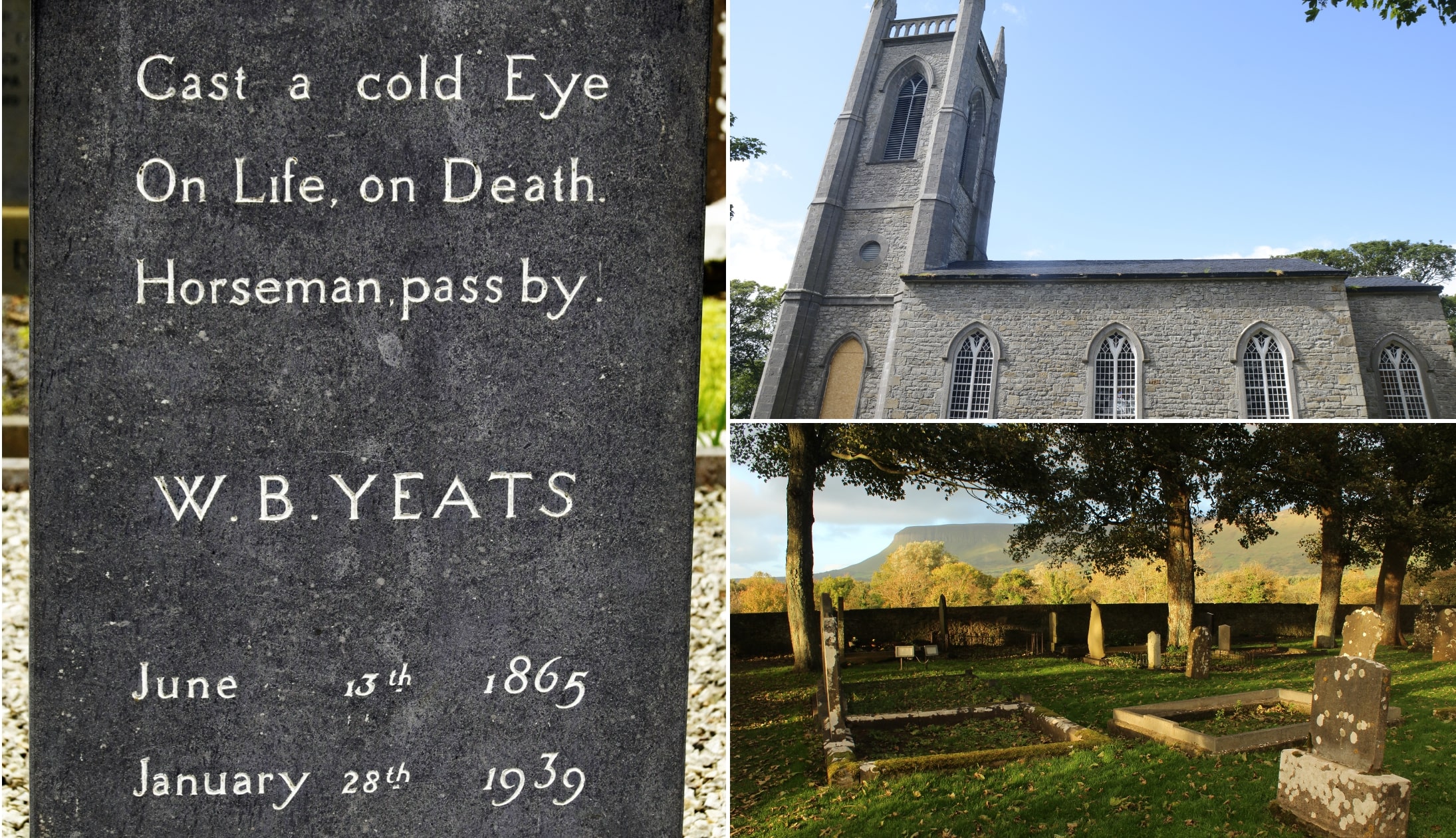
4. Drumcliffe Church and WB Yeats Grave
Photos via Shutterstock
Drumcliffe Church, the final resting place of WB Yeats, is a 15-minute drive from Sligo Town.
A visit to the grave is a cultural experience, but there’s much more to enjoy at the church.
Check out the 11th-century high cross and enjoy the gorgeous scenery all around before checking out the craft shop and cafe.
5. Glencar Waterfall
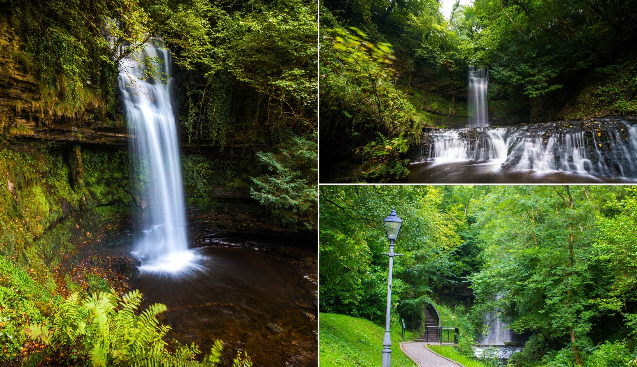
Photos via Shutterstock
From Drumcliffe Church, it’s a 20-minute drive over the border into County Leitrim to the Glencar Waterfall car park, where you’ll also find public toilets.
Once you’ve parked up, the waterfall is a short 300-metre walk away.
The cascade crashes down 50 ft of green foliage and craggy rocks, creating a gorgeous scene tucked away in the woods. In fact, its beauty inspired WB Yeats to write a poem about it.
6. Benbulben Forest Walk
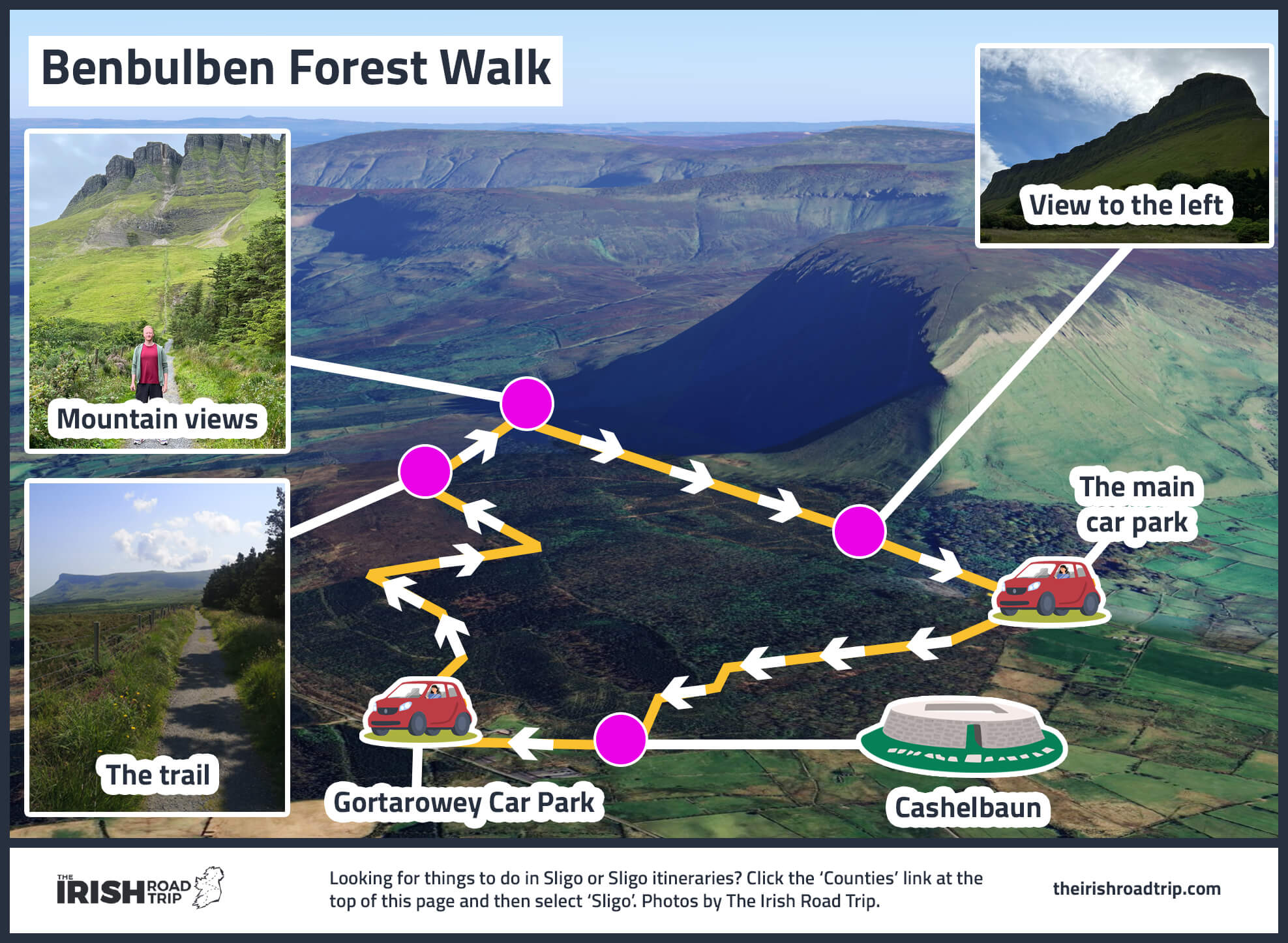
Benbulben Forest Walk is a 15-minute drive from Glencar.
Coming in at a breezy 5.5km, this Benbulben walk should take you around 1.5 hours to complete.
Add on a bit of time if you want to gawp at the mountain or take in the sea views.
As this ramble doesn’t actually involve climbing the mountain, the trail is quite flat and should be no bother for those with even a medium-level of fitness!
7. The Gleniff Horseshoe drive
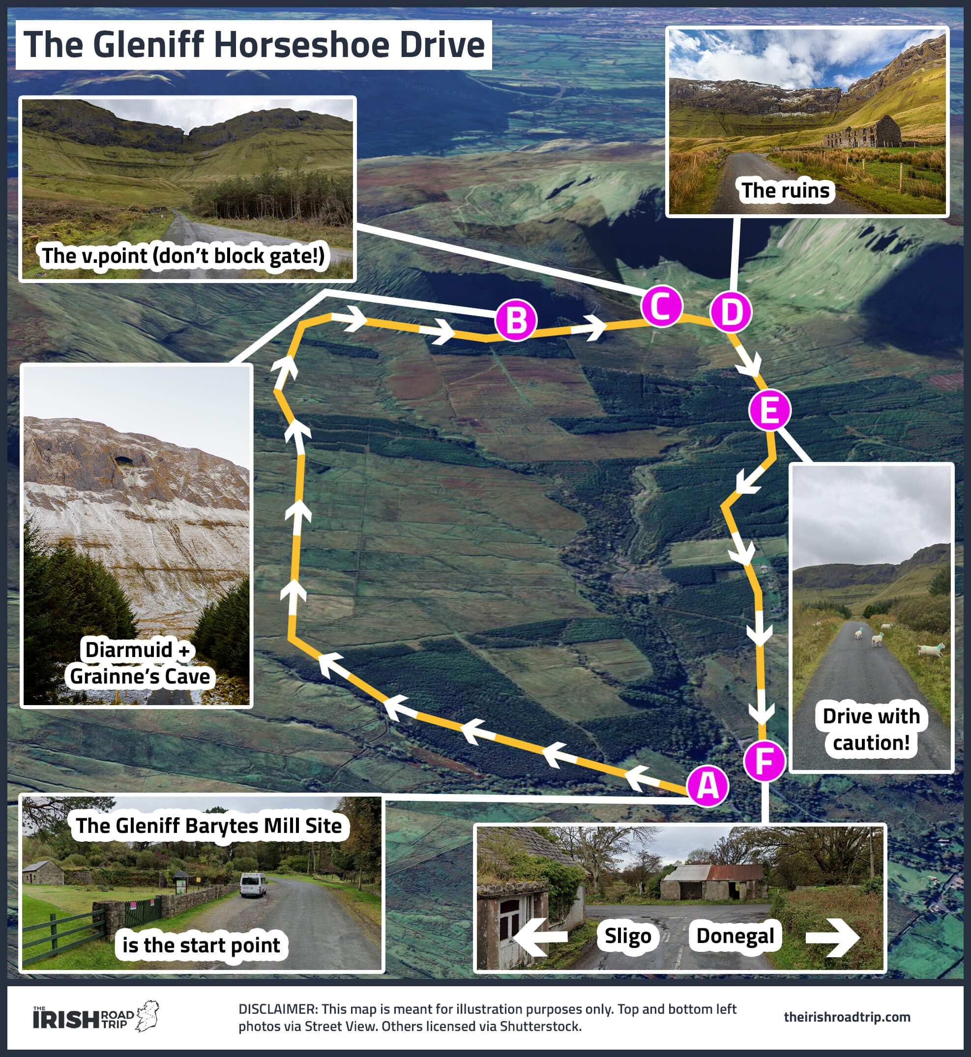
After that walk, you’ll get a chance to rest your legs as you enjoy the wonderfully scenic Gleniff Horseshoe Drive.
The drive starts and ends in the charming village of Cliffoney, which is about 12 minutes away.
The Gleniff Horseshoe is a 20km loop that offers spectacular views of the Dartry Mountains and Donegal Bay.
There’s plenty to see along the way, including wild scenery, megalithic monuments, and a huge cave high up on the slopes. Also, look out for Benwiskin – the wave-shaped mountain at the entrance of the valley.
Keep an eye open for the impressive Grainne and Diarmuid’s Cave up in the hills.
8. Sligo Town for the night

Photos left and bottom right: The Irish Road Trip. Top right via McLynn’s
Day 8 of this Wild Atlantic Way guide comes to an end in Sligo Town, a 35-minute drive from Gleniff.
- Restaurants in Sligo: Hooked for delicious Irish and international food or Coachlane for seafood and steaks
- Pubs: Hargadon Bros (dating back to 1868), Thomas Connolly (the oldest in Sligo Town) and McLynns Bar (great Guinness and live tunes)
Day 9: Sligo to Ardara via Slieve League

Day 9 of this Wild Atlantic Way guide sees you leave Sligo, following the coast up into Donegal.
You’ll stop for a coastal ramble in Bundoran, see Donegal Castle, visit the towering Slieve League Cliffs and tackle many of the best things to do in Donegal.
Where to stay in Ardara on night 9
Accommodation in Ardara can be tricky-to-find during peak season, as the town no longer has a hotel. I’ve found both the Atlantic Lodge and Hillhead House to be great little home-from-homes.
Each is right in the town and a short ramble from pubs and places to eat.
1. Bundoran

Bundoran is a handy 40-minute spin from Sligo.
When you arrive, park up and head off on the Rougey Cliff Walk – a 4km trail that’ll take you around 1 hour to complete.
The trail starts and ends at Bundoran Tourist Office (here on Maps). If you are driving, you can find parking around here on Google Maps.
You’ll enjoy mighty views and see some very unusual landmarks linked to Irish folklore.
2. Donegal Town
Photos via Shutterstock
Donegal Town is a 30-minute spin from Bundoran.
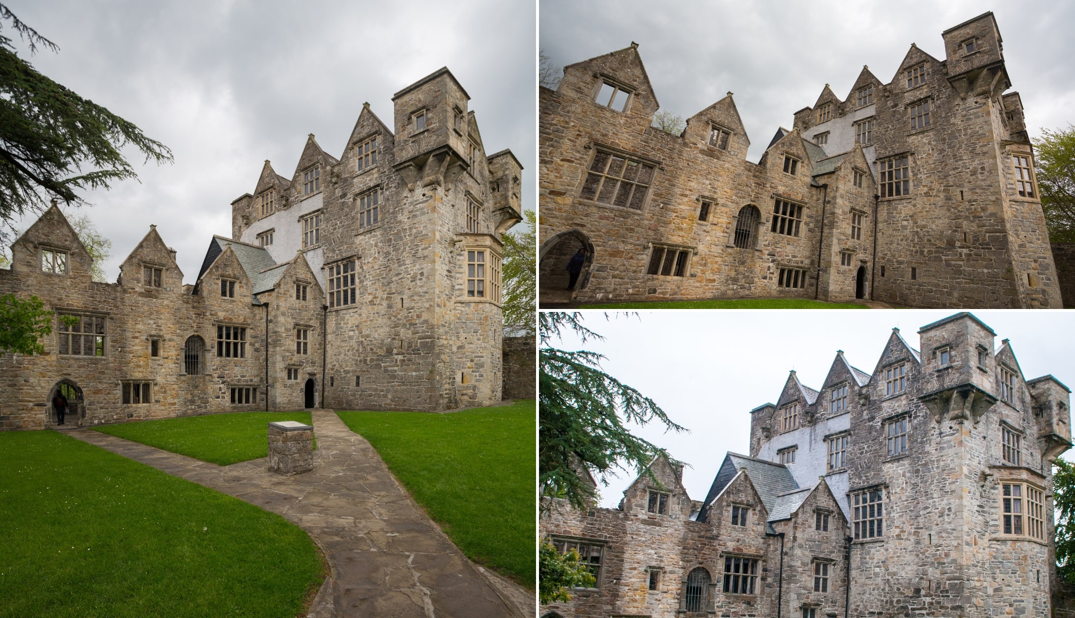
Park up and head for Donegal Castle. It is said that when Donegal Castle was originally built in 1474, it was the most impressive of the many castles the island boasted at the time.
Former seat of the mighty O’Donnell clan, it’s seen many battles and is steeped in history. One of the best ways to learn more is to take a tour of the grounds.
Along the way, you’ll take in barrel-vaulted storerooms, a magnificent carved fireplace, and an uneven “trip” stairwell to catch enemy intruders unawares.
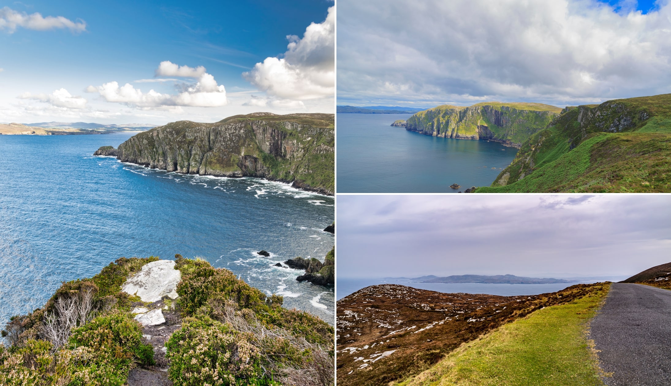
3. The Slieve League Road Trip

The Slieve League Peninsula is home to some of the county’s top attractions.
I’ve whipped up a little road-trip route for you to follow, starting in Donegal Town and finishing in Ardara.
- Killybegs: Ireland’s largest fishing port. Grab breakfast at Mrs B’s, explore the town on the Walk and Talk Tour, or take a boat trip along the coast
- Fintra Beach: A golden sandy beach just outside Killybeg
- Largy Waterfall and Viewpoint: Only visit Donegal’s hidden waterfall if you’re extremely confident with tide timings
- Muckross Head: A Wild Atlantic Way Discovery Point with stunning views
- Slieve League Cliffs: Among Ireland’s highest sea cliffs
- Malin Beg Beach: A horseshoe-shaped beach surrounded by cliffs and turquoise waters
- Glencolumbkille: A Gaeltacht village perfect for lunch. Visit the Folk Village or admire the cliffs
- Maghera Beach and Caves: A secluded beach with towering cliffs and hidden caves
- Assaranca Waterfall: A stunning waterfall that’s easily accessible
- Glengesh Pass: A dramatic mountain pass with winding roads and breathtaking views
4. Ardara for the night
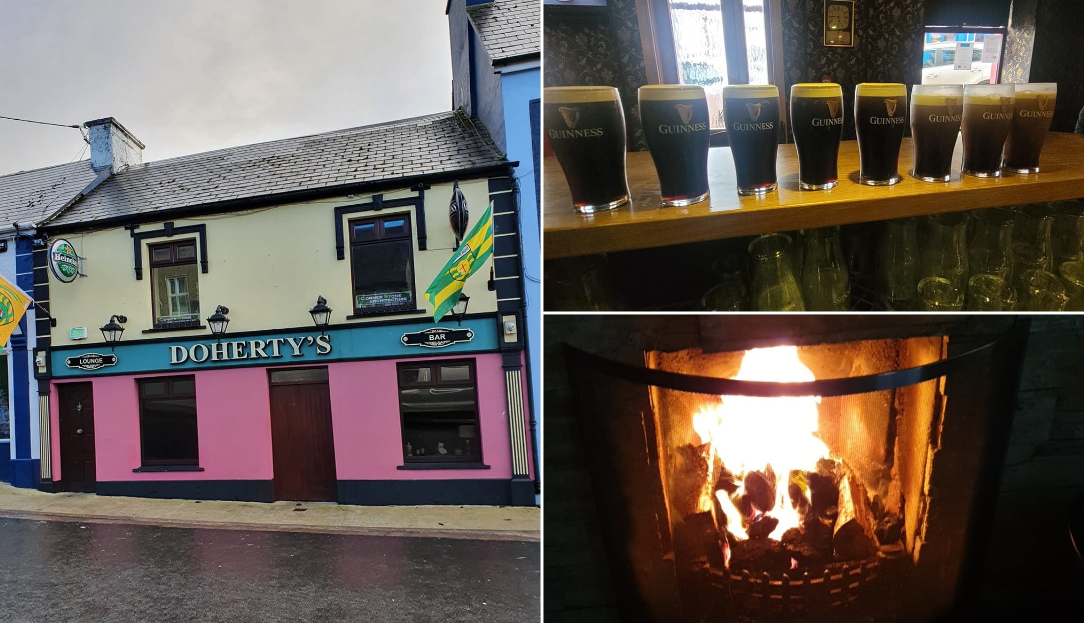
Photos via Doherty’s Bar on FB
Ardara showcases life in ‘rural Ireland’ at its very best and it’s a 15-minute drive from Glengesh.
The village is beautifully maintained, there are heaps of traditional pubs and countless restaurants where you’ll get a fine feed.
- Places to eat: Nancy’s and The Courthouse Restaurant
- Great trad bars: Teague’s Bar (unfussy décor and friendly atmosphere), Doherty’s (its bright pink exterior is hard to miss) and The Corner House (for live tunes)
Day 10. Ardara to Letterkenny via Glenveagh and more

Day 10 of this Wild Atlantic Way route sees you leave Ardara and move further up into Donegal.
You’ll spend the final 2 nights in Letterkenny Town, while exploring all around you.
Where to stay in Letterkenny on nights 10 and 11
Any time I stay in Letterkenny I stay in either the Station House Hotel or the Radisson Blu Hotel.
Both are excellent hotels right in the town, a short stroll from plenty of restaurants and pubs.
1. Glenveagh National Park
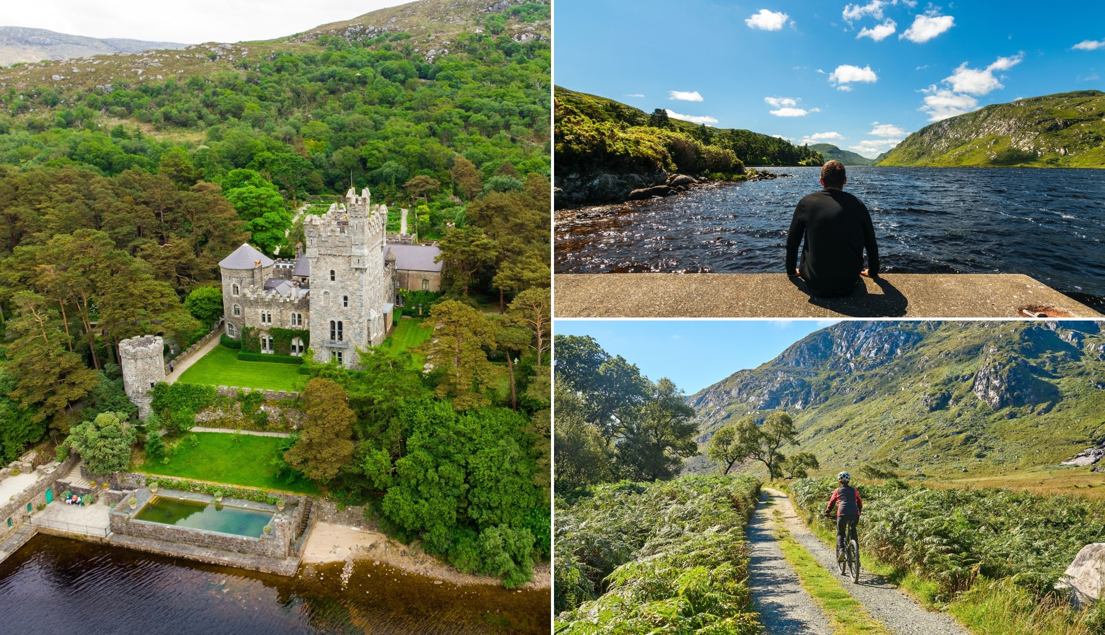
Photos via Shutterstock
Our first stop for the day is Glenveagh National Park, a 16,000 hectares of parkland that takes in loughs, forests, rugged mountains, waterfalls, and a castle.
It’s only a 1-hour drive from Ardara, and there’s a large car park at the entrance, complete with toilets and a visitor centre.
If you want to visit Glenveagh Castle, there’s a shuttle bus which runs regularly between the car park and the castle.
You can also walk or cycle there, with an easy-going 3.5 km walk along the shores of Lough Veagh. This will typically take about 40 minutes and is well-signed. You can also rent a bike and cycle to the castle.
2. Dunfanaghy for lunch
Photos via the Oyster Bar on FB
When you finish in Glenveagh, take the 20-minute spin to the wonderful little town of Dunfanaghy.
Grab a bit of lunch (both the Rusty Oven Pizzeria and Cafe Arnou are good options!) and then head for a stroll on Killahoey Beach.
3. Horn Head Drive
Photos via Shutterstock
The mighty Horn Head is a fine spot to soak up views and ocean air!
Jutting out into the North Atlantic with some seriously epic views, Horn Head is home to sweeping panoramas, dramatic cliffs and even a WW2 lookout tower.
The Horn Head Drive takes you along some very narrow roads that’ll treat you to stunning ocean and cliff views.
Now, you can start this wherever you like, just aim for this location on Google Maps to get on the right route. Here’s a full guide to the drive.
4. Marble Hill
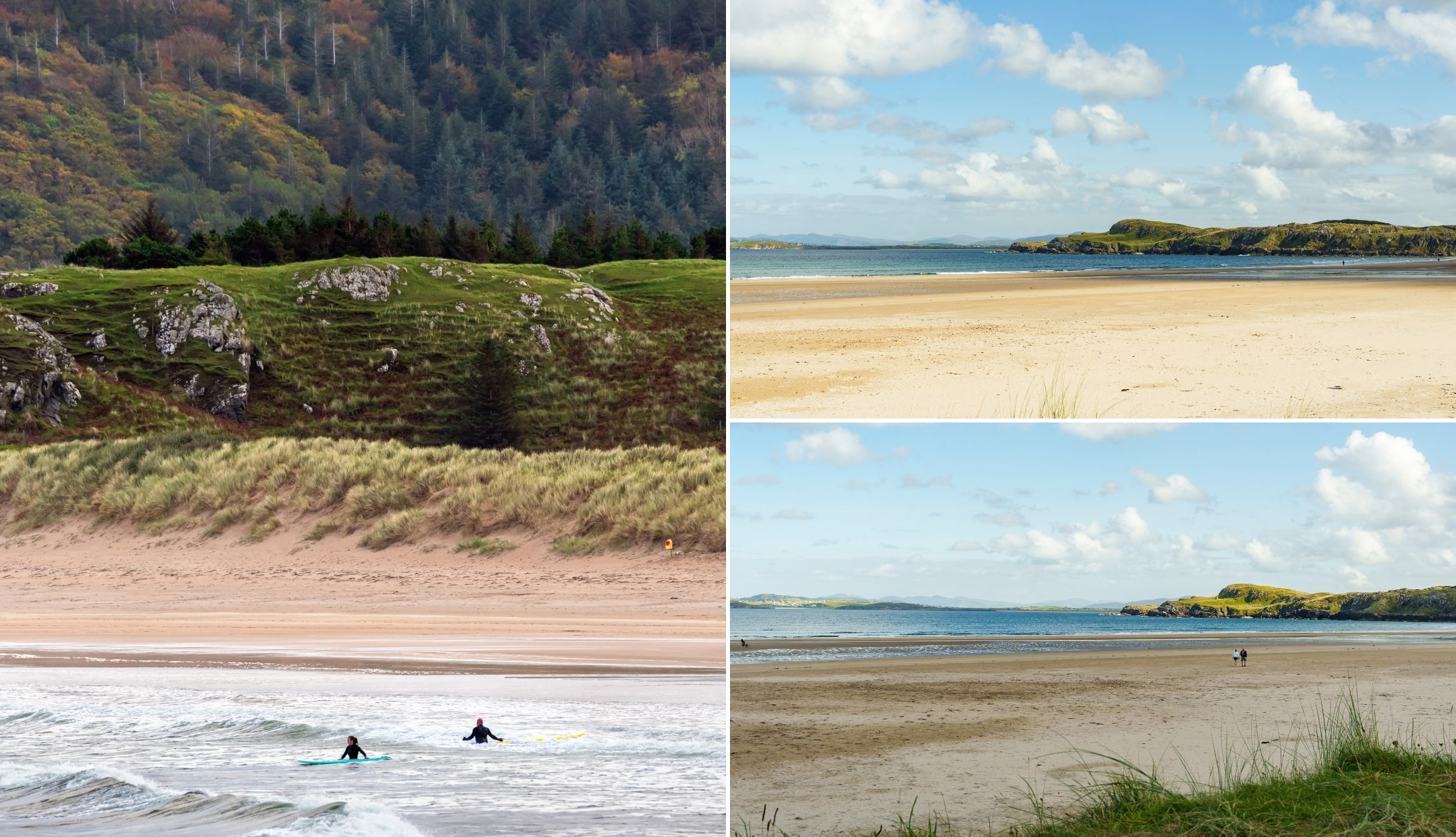
Photo left: Gareth Wray. Others courtesy Failte Ireland
Marble Hill is around a 10-minute drive from Dunfanghy and it’s one of the best beaches in Ireland.
One of the reasons a walk here is so delightful is the beach’s stunning view across Sheephaven Bay toward the Rosguill Peninsula.
To the east of Marble Hill Beach lie two rocky, uninhabited islands: the larger Clonmass Island and the smaller Gull Island.
5. The Atlantic Drive
Photos via Shutterstock
Leave Marble Hill and take the 30-minute drive to Downings.
From Downings, you’re going to follow a route known as the ‘Atlantic Drive’, which will take you right the way around the peninsula, past some outstanding scenery.
The Atlantic Drive takes you around the Rosguill Peninsula, and you can kick it off from Downings. It follows an easy-to-follow route (see map in this guide) and takes in some breathtaking scenery.
The drive itself only takes around an hour, but allow more if you plan on stopping off along the way (you should!).
You can also, if you like, take the hike over to see the famous Boyeeghter Bay!
6. Fanad Head Lighthouse

Click to enlarge
Fanad Head Lighthouse is a 30-minute drive from Downings and there’s something immensely special about this place.
Especially when you visit during the off-season, as the chances are you’ll have the whole area to yourself.
Perched on the edge of the dramatic coastline of northern Donegal, the working lighthouse dates back to 1817.
If you want to get closer, there are two tours to enjoy. The first is a self-guided tour of the grounds and the exhibitions.
The guided tour offers the same but also takes you up to the tower for some amazing views.
7. Portsalon Beach
Photos via Shutterstock
The mighty Portsalon Beach is a short but spectacular 20-minute drive from Fanad Head Lighthouse on the east side of the peninsula.
There’s parking near the southern end of the beach, making it easy to stop and enjoy all the beach has to offer.
Also known as Ballymastocker Bay, Portsalon is a beautiful Blue Flag beach with long stretches of sand for rambling, clear water to swim in and plenty of waves for surfer.
The views from this beach are simply breathtaking, and it’s well worth taking a gentle stroll along the 1.5 km stretch of sand.
8. Letterkenny for the night

Photos left + bottom right: Via The Cottage on FB. Other via Google Maps
Night 10 of this Wild Atlantic Way guide comes to an end in Letterkenny, a 35-minute drive from Portsalon.
Now, Letterkenny tends to get overlooked – but it’s a handy base that’s home to plenty of great pubs, restaurants and places to stay.
- Pubs in Letterkenny: The brilliant Cottage Bar is a great example of a proper trad pub
- Restaurants in Letterkenny: Both Yellow Pepper and the Lemon Tree do top-notch food
Day 11. The Inishowen Peninsula

Your Wild Atlantic Way itinerary is coming to end but worry not – there’s plenty to look forward to on the final day.
Today, you’ll leave Letterkenny and explore the Inishowen Peninsula via a very scenic driving route.
1. The Inishowen 100
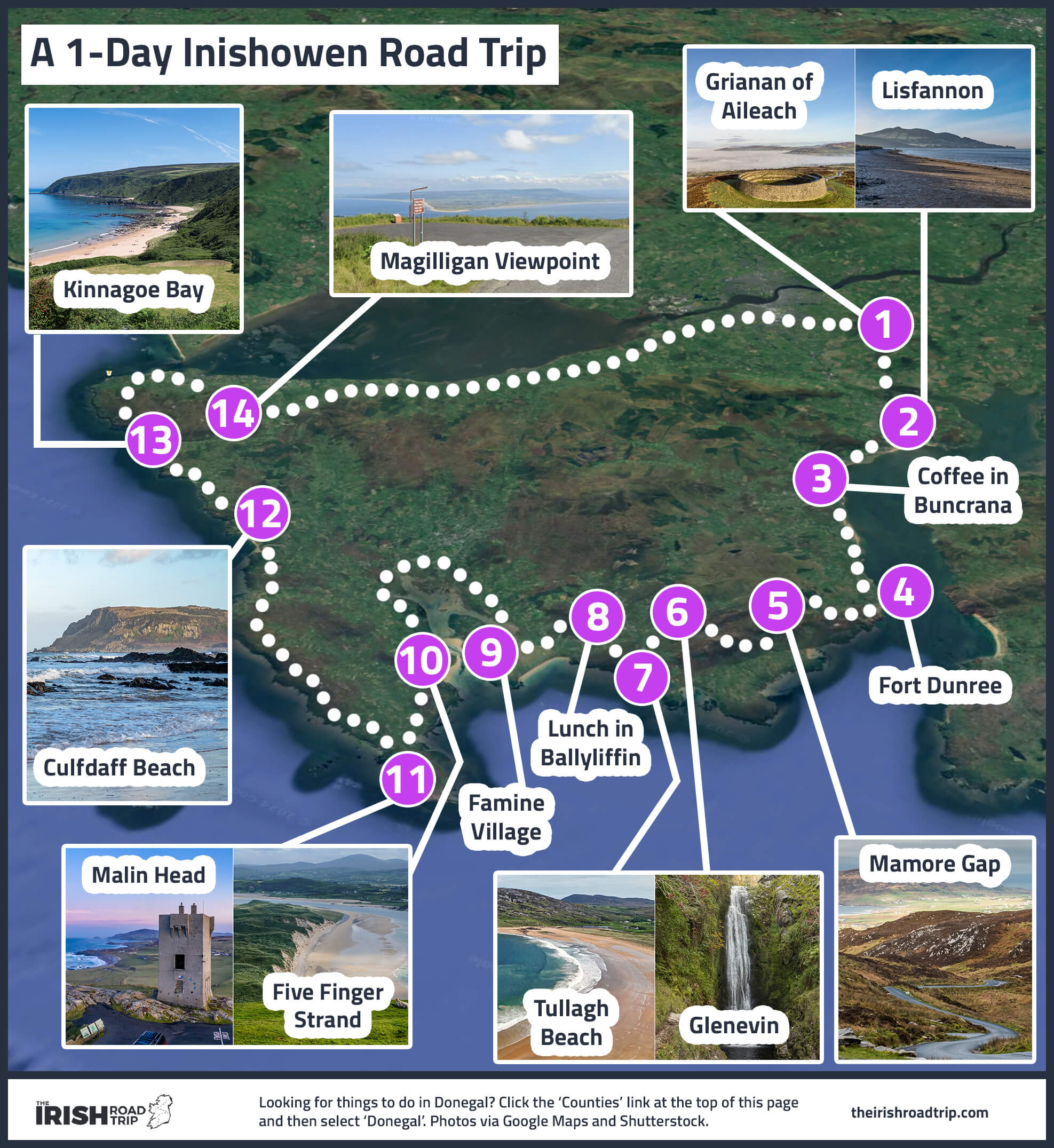
The final stretch of your Wild Atlantic Way road trip sees you embark on the mesmerising Inishowen 100.
This is a 100 mile (hence the name) route that takes you right the way around the peninsula.
Here are the stops:
- Grianán of Aileach: This ancient stone fort offers panoramic views from its hilltop location
- Lisfannon Beach: A scenic beach with stunning coastal views
- Buncrana Beach: Perfect for a stroll. Need a caffeine fix? Drop by Tank and Skinny’s
- Fort Dunree: A 19th-century coastal defence fort, now a museum
- Mamore Gap: A winding, narrow road through the Urris Hills with spectacular views
- Glenevin Waterfall: A 40ft cascade reached via an easy 1-hour round-trip walk
- Tullagh Strand: A horseshoe-shaped beach overlooked by Binnion Hill
- Ballyliffin Beach: A 2.5km sandy stretch that’s perfect for a walk. For lunch, pop into Nancy’s Barn in Ballyliffin
- Doagh Famine Village: An interactive museum that tells the story of Irish life from the Great Famine to modern times
- Knockamany Viewpoint: Enjoy stunning panoramic views.
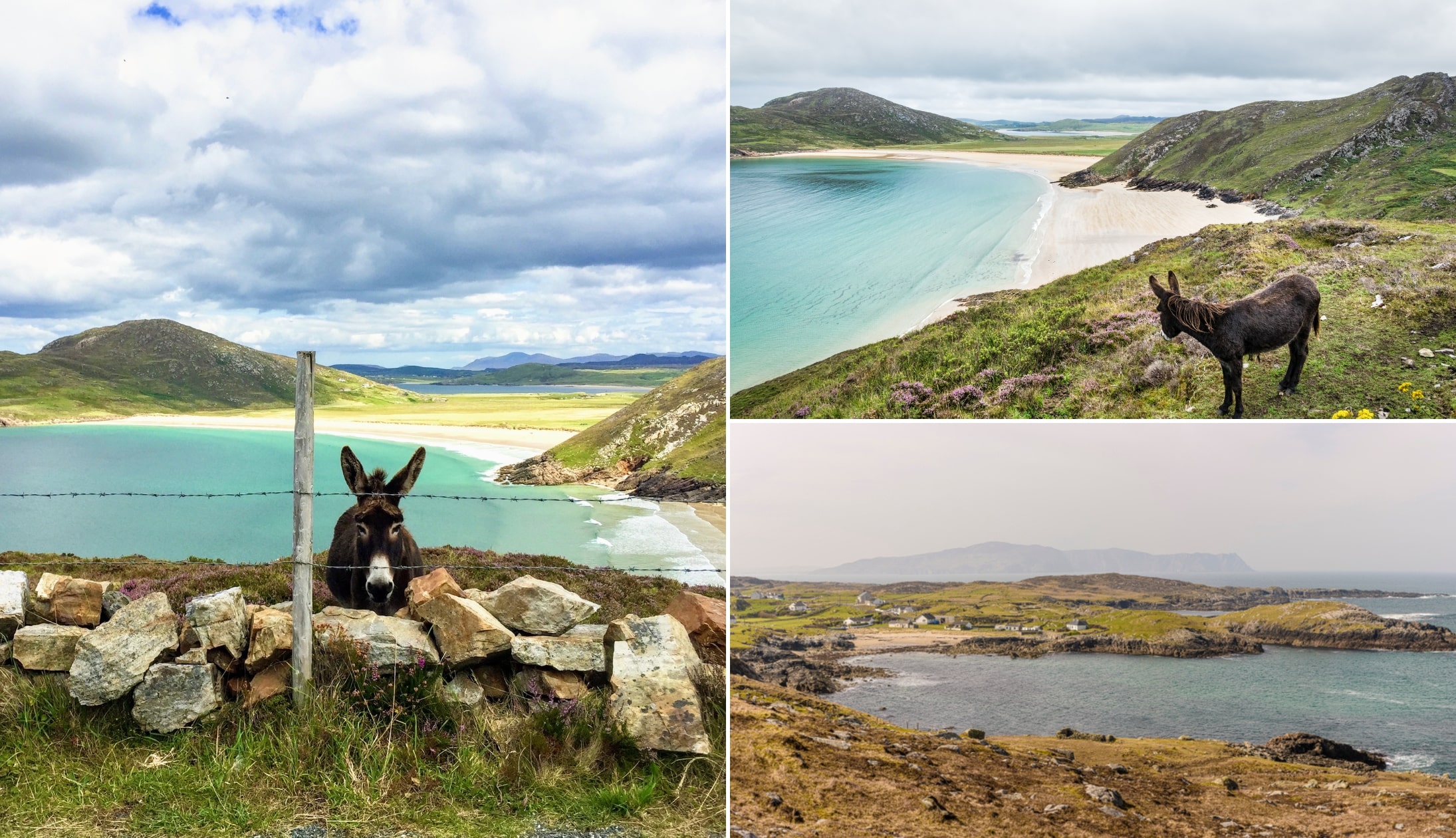
- Malin Head: Ireland’s most northerly point.Take the 50-minute walking route to explore it
- Culdaff Beach: Grab a coffee at Cúl a’ Tí and enjoy the beach views
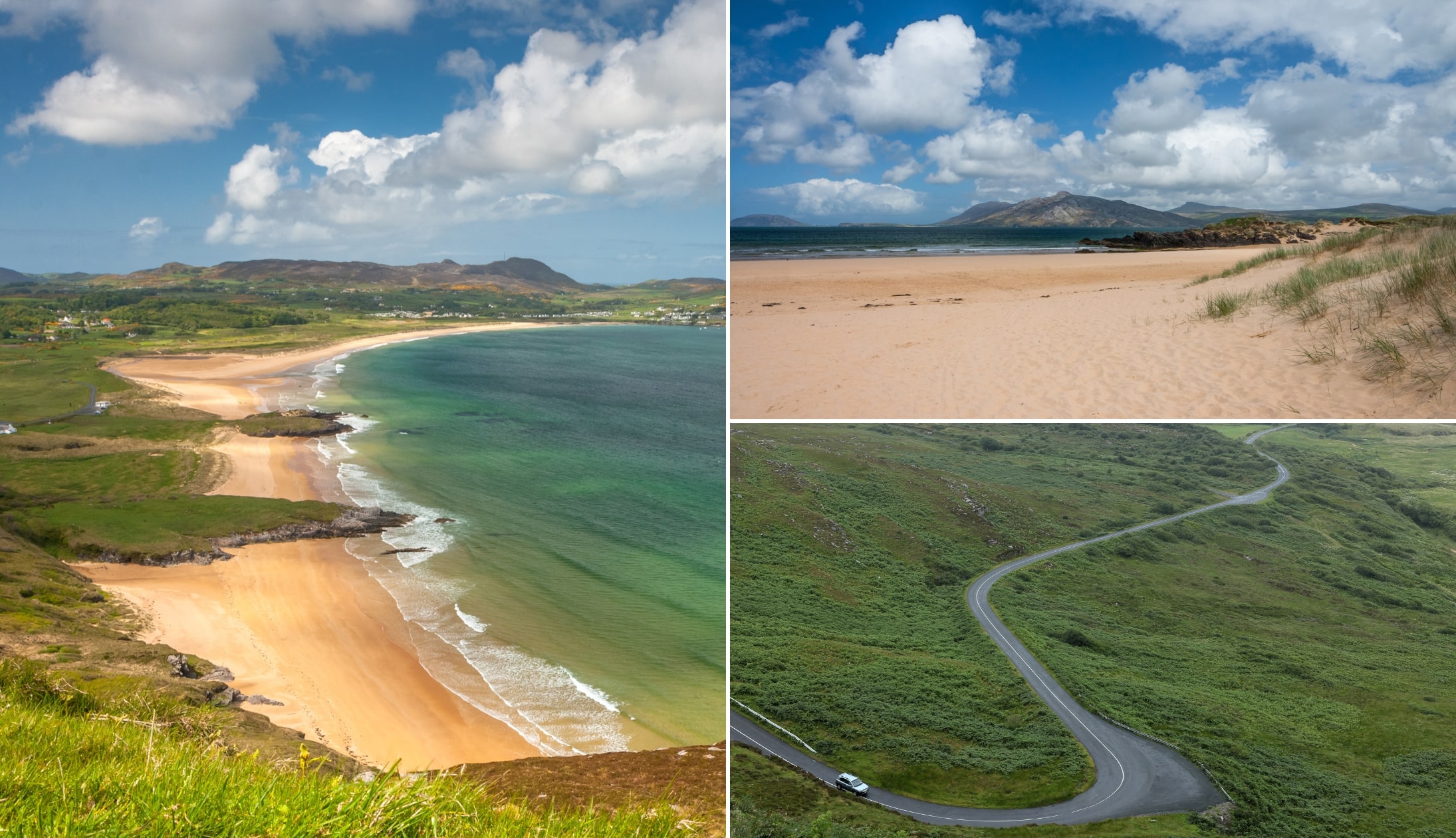
- Kinnagoe Bay: A hidden gem home to an Armada shipwreck from 1588
- Magilligan Point View: A Wild Atlantic Way discovery point outstanding views
- Inishowen Lighthouse: Take a stroll along the sand or try the Inishowen Head Walk
- Back to Letterkenny: It’s a 1-hour drive back
Wrapping up this Wild Atlantic Way road trip
And with that, this Wild Atlantic Way itinerary comes to an end.
As I’ve mentioned many times, if this trip is too fast for you, don’t worry – you can pick much slower road trips in my Irish Road Trip Library. You can choose:
- Your start point
- Your mode of transport
- Your fitness level
- How fast you like to travel
An interactive Wild Atlantic Way map
The map above will help you plan out your Wild Atlantic Way itinerary.
It has everything from discovery points, attractions, viewpoints that many people miss and lots more.
Keith O’Hara has lived in Ireland for 35 years and has spent much of the last 13 creating what is now The Irish Road Trip guide. Over the years, the website has published thousands of meticulously researched Ireland travel guides, welcoming 40 million+ visitors along the way. In 2022, the Irish Road Trip team published the world’s largest collection of Irish Road Trip itineraries. Keith lives in Dublin with his dog Toby and finds writing in the 3rd person minus craic altogether.
Isobel
Saturday 19th of July 2025
Hi Keith,
We’re currently half way though our road trip following your WAW guide and are absolutely loving it. The detail you’ve gone into on here has been an absolute life saver and made our (as well as many other people’s) lives a lot easier!! Thank you so much for taking the time to make this it is my favourite website I have ever used ever and might need to come back and look at it even when not on a road trip lol. Looking at your little face at the end of each day brings light to even the gloomiest of days.
All the best, Isobel, Anna, Yas and Sunaa
Keith O'Hara
Thursday 24th of July 2025
Hi Isobel, Anna, Yas and Sunaa!
Great to hear you've been enjoying the route! Really delighted to read this feedback and to hear you're having such a memorable trip.
I hope you got some decent weather for your trip!
Cheers and thanks again!
Keith
Yvonne
Tuesday 3rd of October 2023
Hi Keith
You are a STAR. We have just returned to the UK after driving most of The Wild Atlantic Way over a few weeks, and all the information and tips that you gave in the guide for the Way made it an amazing trip, despite not being sunshine all the way. We loved it and have already said that we will return in the future. Thank you so much for all the hard work you must have put into the guide. Best wishes Yvonne & Robert
Martin jeffries
Tuesday 10th of January 2023
hi keith. i will be sailing from the uk do you know which port i sail from and which port in ireland do i sail into, im planning for 2024 possibly early august. thanks martin from wolverhampton.
Keith O'Hara
Monday 16th of January 2023
Hi Martin - I have absolutely no experience with sailing and I wouldn't like to provide you with inaccurate information that could potentially cause your trip a massive disruption. Apologies - I know this wasn't the reply you were looking for!
Aziza
Monday 9th of January 2023
Hi Keith, My husband and I are travelling to Ireland from Toronto Feb 10-20, its our very first time there and we’re superr excited(despite all the rain we’re guaranteed)! Our Itenerary is below, this site has been an incredible resource so far and it would be a huge help if we could get some guidance/POV on this - are we trying to do too much, any major point that we’re missing? We’re not into heavy hikes but enjoy partying/eating/drinking and leisurely walks. We’ve booked our Galway stay already but completely flexible with the rest
Day 1 - Land in Dublin (rent car at 7am) Drive to Galway with a stop at Seans bar, spend the evening/dinner in Galway Spend 2 nights in Galway Day 2 - Explore Galway (or is it worth taking a Day trip to Mayo from Galway?) Day 3 - Checkout from Galway, drive to Limerick, stop at Cliffs of Moher, Donagoore Castle, Loop head lighthouse Spend 2 nights in Limerick Day 4 - Drive through Ring of Kerry (spend night in Limerick) Day 5 - Checkout from Limerick, Visit Adare, Tipperary, Cashel Spend 1 night in Cashel/Tipperary Day 6 - Drive to Cork and spend day exploring Cork city Spend 1 night in Cork Day 7 - Explore cork city, Cobh, drive to kilkea castle Spend 1 night in Kilkea Castle Day 8 - Drive to Waterford, spend day exploring Waterford, Drive to Dublin (return rental car in Dublin) Spend 3 nights in Dublin Day 9 - Explore Dublin, Trinity College, St Patricks Cathedral, Christchurch cathedral, brazenhead pub Day 10 - Take viator Day trip of Nothern Ireland (Belfast, Giants Causeway, Dunluce castle) Temple bar at night Day 11 - Take flight back to Toronto Thanks & Cheers!
Keith O'Hara
Monday 16th of January 2023
Hey Aziza,
Sorry it's taken me so long to get back to you!
Definitely add in Athlone Castle on day 1. On day 2, you've asked about Mayo. It's an incredible county, but I think you'll stretch yourself too thin, so dedicate the day to Connemara.
Day 3 - lot of driving on this day. The spin out to loop head, although well worth it, is quite long. Day 4, again, a lot of driving but doable if you're set on staying in Limerick. Day 5 looks fine. Day 6 looks fine.
Actually, at a glance at the other days everything else is fine, it's just a very busy itinerary.
It's not the kind of trip that would suit everyone, but if you're happy to pack in as much as possible then this all looks very doable to me.
Have a great, safe trip!
Keith
Murillo Fabris
Monday 17th of August 2020
Hey Keith, just passing by to say what an amazing guide, super well laid out! We are doing it in reverse, This is the only side of Ireland we haven't seen yet. Thank you again and keep up the good work!