
The strenuous Mount Brandon Hike is one of my favourite things to do in Dingle and it’s arguably one of the best mountain hikes in Ireland.
It’s extremely challenging at times, but the views you’re treated to while climbing Mount Brandon are as spectacular as they are diverse.
In this guide, you’ll find a route to the 952-metre-high summit of Mount Brandon, with an overview of the trail from the Faha Grotto side.
Quick need-to-knows about the Mount Brandon hike
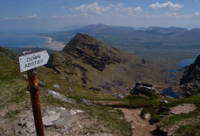
Photo by cozizme on Shutterstock
Although the Mount Brandon hike is much more straightforward than the likes of the Carrauntoohil hike, proper care and planning is required.
Please take some time to read through the need-to-knows below, before you rush off and go about climbing Mount Brandon (you’ll also find info on a guided hike later in this guide).
1. Warning
Even the most accessible mountain hikes can become a nightmare if the weather turns and you’re not prepared. The Mount Brandon Hike is far from easy at the best of times, and it really isn’t ideal for inexperienced hikers that aren’t familiar with a map and compass.
Even though the trail is fairly well-marked, it doesn’t take long for the clouds to roll in and obscure the views.
So, wear layers, bring waterproofs and a sturdy pair of boots and make sure you have a good map to hand. Start early in the day, and check the weather in advance.
2. The start point
There are a couple of ways that you can go about climbing Mount Brandon, and if you prefer the quick and easy route, approach from the west side (Dingle Town) and take the medieval pilgrim’s path (The Saint’s Route).
Personally, I prefer the longer trail that approaches the summit from the east, at Faha Grotto, close to Cloghane.
3. Parking
If you start the Mount Brandon hike from the Faha side, you’ll find a pokey little car park that can fit around 8 cars, if people park properly (not always a given…).
If you’re planning on climbing Mount Brandon during the summer on a fine day, try and get here early to avoid missing out on a spot.
4. Difficulty level
Although this route is considered the difficult route compared to the easier trail that starts in Dingle, it’s well worth the extra effort.
It does get hard going at points, with some sections of sheer rock faces, but it’s manageable for people with a moderate fitness level. It’s particularly strenuous on the way down, which can be pretty steep and slippery in bad weather.
5. Time it takes
On average, the Mount Brandon hike detailed below takes between 6 and 7 hours, up and down, but it all depends on the weather conditions and how long you spend admiring the view.
With rivers, waterfalls, lakes, mountains, the ocean, and stunning beaches to take in along the way, you might find yourself stopping to snap the scenery pretty often!
The best advice is to tackle the Mount Brandon hike between May and September, and get a nice early start, to ensure you’ve sufficient daylight.
The Mount Brandon hike: A guide to the trail

Photo via Google Maps
Okay, so that’s the basics out the way — let’s start hiking! Now, again, please do take proper care in prepping for this hike.
Good footwear, some water and snacks to keep you going are necessary, to say the very least.
Kicking off the Mount Brandon hike
Right off the bat the surroundings are spectacular. As you leave the car park and follow the well-signed grassy trail towards the grotto, you’ll see the sea and sand behind you, while rolling green hills become mountains up ahead.
The views only get better from here on out too, as you really start climbing Mount Brandon. Once you’ve passed the grotto, the grassy path winds up the face of the mountain, becoming rockier underfoot.
Follow the white poles, but don’t forget to take a look back at the incredible views over Brandon Bay and the Maharees.
Soon enough, you’ll start seeing a number of mountain lakes sparkling in the distance, and the trail will start to veer right, obscuring the views behind you. Keep your eyes peeled for the plane crash site (F8+KH), where you’ll find a memorial bench.
Reaching the cliff face
All of a sudden the landscape transforms into something completely different. Gone are the sea views, sandy beaches, and gentle green slopes. Soon enough you’ll come face to face with what looks like a sheer cliff face.
But don’t worry, you won’t be needing climbing gear to reach the top! As you find yourself embraced by the mountains, the wind calms, and you’ll start hearing the soothing sound of water spilling out of the rock face.
You’ll feel tiny, but it is possible to conquer the cliff face – just take your time! Follow the white arrows and watch your footing as the path becomes fairly narrow and rocky at points.
This section of climbing Mount Brandon is tough, and a fair bit of scrambling is needed, at times, but the views over the mountain lakes are amazing. And, before you know it, you’ve reached the ridge, and you’ll see the sea once again!
Arriving to the summit of Mount Brandon

Photo by Colm K (Shutterstock)
Once you’ve scrambled out of the valley and onto the top of the ridge, you’re not too far from the summit. Stop to catch your breath, and if the weather is fair, take a look around and take in the incredible views.
On a clear day, you should be able to the Blasket Islands, while vibrant green fields sprawl out below, before dropping into the sea over sharp cliff edges.
Next, head left, and it’s just a gentle, 500-metre walk to the summit. Warning: this section of the mountain is notorious for being covered in cloud, at times.
If you’re in any doubt of your ability to use a map and compass, consider taking the guided hike we mention at the end of this guide.
The long way back to the car park
Once you’ve had a well-earned cup of tea and a sandwich (bring your own) at the summit, it’s time to head back down.
If you found climbing Mount Brandon hard, you’re about to find the descent a whole lot trickier in places. The steep rocks can be a real knee basher, so take care and take your time, especially in damp weather.
The easiest way to return is the way you came, as the path is fairly well-marked. Take your time and be careful.
When you’re back at the car, here’s a top tip! Book a room or pitch up a tent at O’Connor’s Bar and Guesthouse in Cloghane, just 3 km from the car park.
This 150-year-old inn is full of rustic charm, sitting at the foot of Mount Brandon. Great food and drink, and a cosy, friendly atmosphere to end a hard day’s hiking.
Things to do near Mount Brandon
One of the beauties of the Mount Brandon hike is that it’s a short spin away from a clatter of other attractions, both man-made and natural.
Below, you’ll find a handful of things to see and do a stone’s throw from Mount Brandon (plus places to eat and where to grab a post-adventure pint!).
1. The Slea Head Drive

Photo by Melissa Bobo (shutterstock)
You can join the Slea Head drive a short distance from Mount Brandon. This drive takes in everything from Dunquin Pier and Coumeenoole Beach to Gallarus Oratory and much more.
2. A pint with a view in Brandon
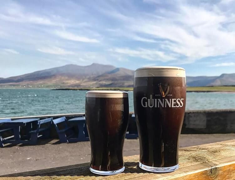
Photo by @clairemcelligott
Murphy’s in Brandon is a fine place for a scenic pint, as you can see above. If you arrive on a clear day, you can sit outside and soak up mountain views.
3. Dingle for food
There’s plenty of great places to eat in Dingle. There are also heaps of pubs in Dingle worth having a nosey around, too. Hope into our Dingle accommodation guide to find a place to stay.
Climbing Mount Brandon with a guide
If you’d like to try the Mount Brandon hike but you’d prefer to do it with an experienced guide, you can always join Kerry Climbing on one of their ascents.
Each ascent with Kerry Climbing is run by an experienced guide who’s familiar with the area, and can take the hassle out of planning the trail.
If you’ve never tried a guided hike and you’re unsure of what’s involved, don’t worry – you’re in good hands here. The reviews for their guided hikes are excellent (4.9/5 on Google at the time of writing).
FAQs about the Mount Brandon climb
We’ve had a lot of questions over the years asking about everything from how high is Mount Brandon to what’s the best route up it.
In the section below, we’ve popped in the most FAQs that we’ve received. If you have a question that we haven’t tackled, ask away in the comments section below.
Is Mount Brandon hard to climb?
The Mount Brandon hike is challenging in places, but most with a moderate level of fitness should find it OK. With that being said, it’s a longish slog to the top and back, which needs to be taken into account before you set off.
How high is Mount Brandon?
Mount Brandon is 952 metres (3,123 ft) high.
How long does it take to climb Mount Brandon?
If you climb Mount Brandon via the trail mentioned above, it’ll take you between 6 and 7 hours in total.
Ed French
Wednesday 9th of July 2025
Don’t be under any illusions, from the Faha grotto, this is a tough hike! The main factor is the fact you are starting from near sea level so you are ascending about 800-850m from the car park over approximately 5k. So that’s 160-170m climb per km on average. As you go along and at the top of the glacial valley with the ribbon of lakes, the view is astounding and the tranquility will feed your spirit. However the trail for the ridge to get to the summit is very difficult. I was going solo and I stopped about 100m from the top and turned back. I wouldn’t recommend you try this section alone unless you are super fit, an experienced rock climber and about 20 years younger than me! While the total distance is about only 10-11k from the car park it is a challenging hike and my legs were like jelly on the way back down. (I’m debating the distance given here as my gps said I had covered 9k from the car park and I still had a bit to go.) I had a fantastic outing - it really is spectacular - and a picnic by the lakes with the summit overhead is enough to be getting on with if you take this route. It’s about the journey not the destination… Be safe.
Peter Morley
Wednesday 7th of September 2022
We went up the easier Saints Way on the west side of Mount Brandon and it took us 3.5 hours for the round hike. It was a beautiful warm and calm day at the base but a bit cool and windy at the top. The ground was dry so shoes were fine and sticks weren't required. The views were fantastic and we really enjoyed the hike. There was plenty of parking but this was mid week in very late August.
There is also a very well sign posted circular hike at nearby Brandon Point that goes to Sauce Creek. Again the views are fantastic and I think it took about 3.5 hours. There is plenty of parking at Brandon Point.