The Sally Gap Drive is a 26km (16-mile) scenic route through the Wicklow Mountains, crossing one of Ireland’s highest mountain passes at around 500m (1,640ft) above sea level. It follows sections of the R759 and the Old Military Road, linking Roundwood, Glendalough and Blessington.
Built in the early 1800s after the 1798 Rebellion, the road now takes in Lough Tay, Glenmacnass Waterfall, open moorland and several popular walking trailheads.
As I live a stone’s throw away, I do this route several times each year – below, you’ll find a map of the Sally Gap Drive along with where to stop along the way.
About the Sally Gap in Wicklow
Photos via Shutterstock
The Sally Gap Cycle / Drive is one of the most popular things to do in Wicklow so, if you plan on doing it at the weekend (especially during the summer months), try and arrive early.
During the summer, the entire area gets mobbed with people, as some of the best walks in Wicklow kick off nearby.
1. What is the Sally Gap
The Sally Gap is a crossroads in the Wicklow Mountains, where you can turn off North to Dublin, South to Glendalough, West to Blessington or East to the village of Roundwood. The Sally Gap Drive is a circular route that takes in a clatter of the area’s attractions.
2. Where the Sally Gap Drive starts
As you’ll see below, we’d recommend that you start the Sally Gap Drive from near Roundwood (there’s a map below), as this route treats you to incredible views throughout.
3. How long it takes
If you start and end the Sally Gap Drive in Roundwood, it’ll take you 60 minutes in total, without stops. Allow at least twice this for stops along the way.
4. Why the road was built
The road (known as Old Military Road) at the Sally Gap in Wicklow was built shortly after the Irish Rebellion (1798). The road was constructed by the British Army who wanted to drive Irish rebel forces from the area.
5. A warning about the weather
I’ve visited the Wicklow Mountains on a number of occasions and was surprised to find that they were covered in snow. It’s often the case that there’ll be no snow on lower ground in Wicklow but, when you start making your ascent, the ground gets icy in places. Always make sure to check the weather in the area before setting off.
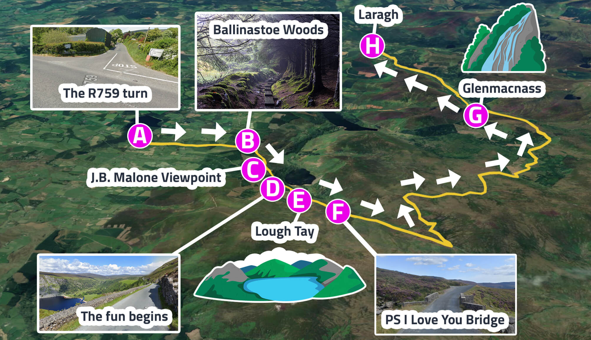
The Sally Gap Drive: My favourite route

I like to kick the drive off in the little village of Roundwood in Wicklow, as I’ll usually nip into a shop and grab a cup of coffee (you can start wherever you fancy, of course!).
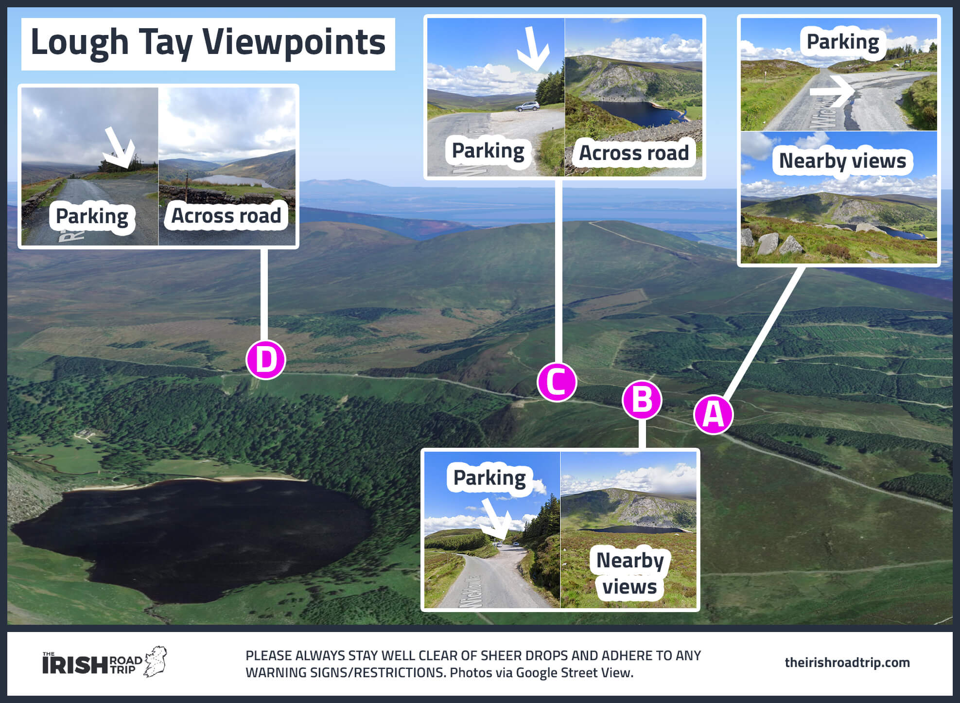
From here, you want to make your way up to the ‘Lough Tay Viewing Point‘, as it’s listed on Google Maps.
You then keep chugging along the road towards the Sally Gap, hang a sharp left, continue around towards Glenmacnass Waterfall and you’re onto the home stretch. Here’s the route broken down.
Stop 1: The stop that isn’t really a stop
Photos via Shutterstock
The scenery that you’re treated to from your seat as you spin along the narrow road that climbs up to Lough Tay is outstanding. I’ve driven this road 15+ times and it still never fails to knock me a little.
The road (the R759) clings to the mountain and you’ll be treated to incredible views out over Lough Tay and a chunk of the Wicklow Mountains.
There are only a handful of places to pull in on this section of the road, but don’t worry – you’ll have plenty more pull-in points ahead.
Optional trails to tackle: There are two popular walks along the first section of this scenic Wicklow drive – Djouce and Ballinastoe Woods.
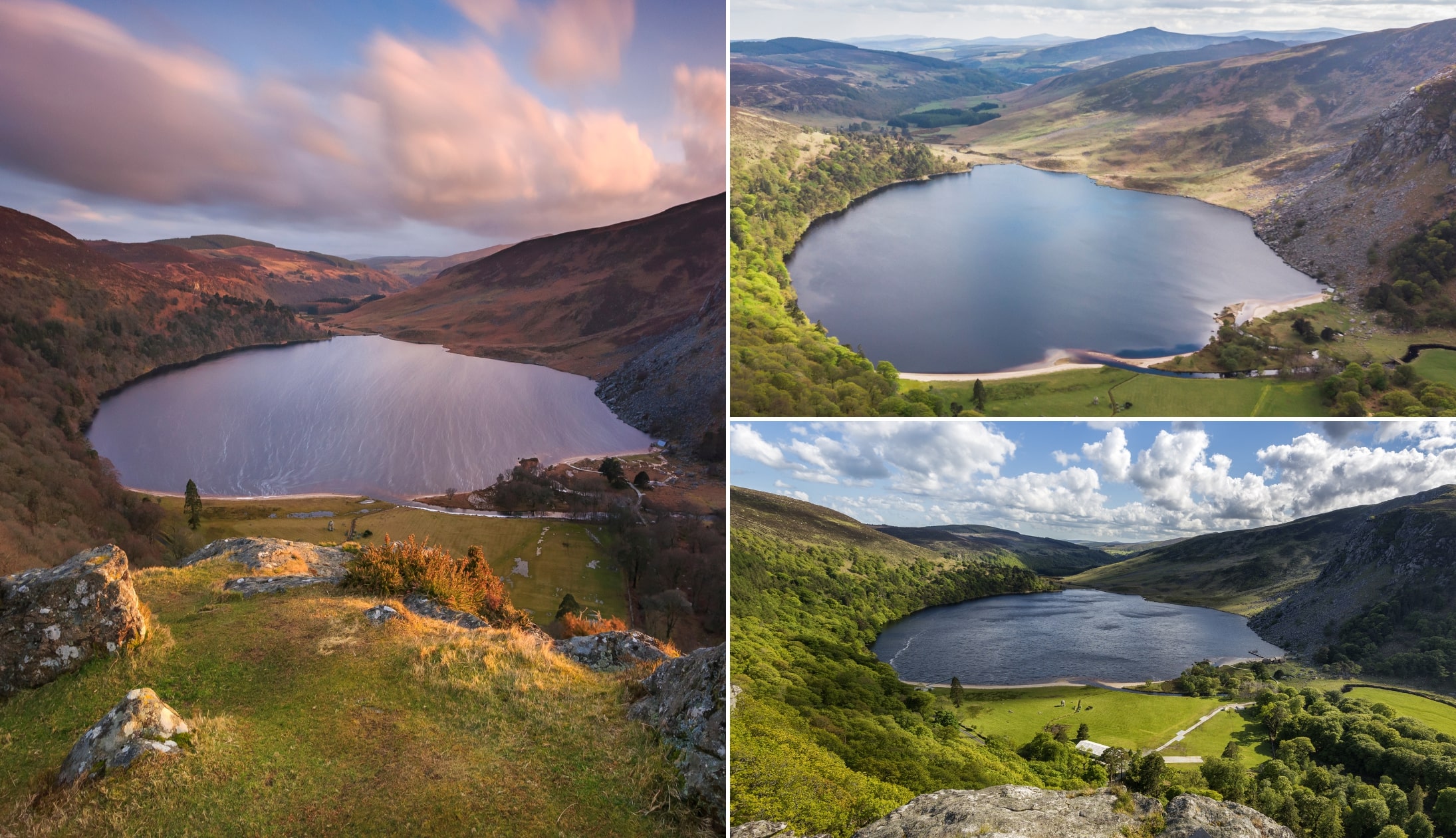
Stop 2: Lough Tay
If you read our guide to Lough Tay aka Guinness Lake, you’ll know that I’m reasonably obsessed with the place. It’d be hard not to be, to be fair!
Lough Tay is a small but scenic lake that’s set on some very fancy private property (currently owned by members of the Guinness family trust) that lies between Djouce Mountain and Luggala.
Now, while you can’t get down to the lake itself, you can get a mighty view of it from above if you aim for the view point (revert back to our Sally Gap Map).
There’s plenty of space to pull in and it’s a short walk from the little car park across to the viewing point. Keep in mind that this viewing point is on private property, so enter at your own risk.
Keep an eye out for: After you leave Lough Tay and head towards the actual Sally Gap, keep an eye out for a little bridge. It was made famous by the movie ‘P.S. I Love You’.
Stop 3: The Sally Gap

Photos via Google Maps
To be fair, you probably won’t be stopping here (aside from at the point where you physically have to stop), but you should be aware of where the Sally Gap actually is.
The Sally Gap (aka ‘Sallys Gap’) is a crossroad (pictured above) that you’ll come to not long after you leave Lough Tay.
The roads here take you North to Dublin, South to Glendalough, West to Blessington or East to the village of Roundwood. Take the turn left and head off on your merry way.
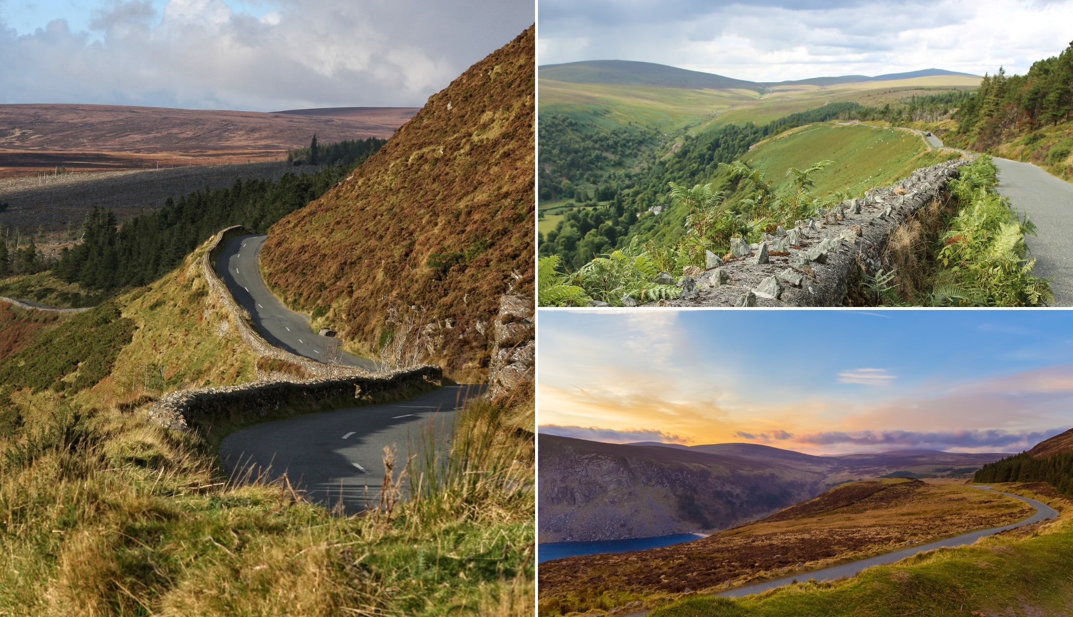
Stop 4. Old Military Road

After taking the turn to the left, you’ll be treated to spectacular views of the surrounding blanket bog and the stunning Wicklow Mountains.
The Old Military Road at Sallys Gap was constructed after the 1798 Irish rebellion and was built by the British Army. They wanted to use the road to flush Irish rebels from the hills.
There are several different places to pull in as you spin along this stretch of road, so make sure to stop (safely), hop out of the car or off the bike, and gulp down a few lungfuls of fresh air.
Keep an eye out for: The trees dotted along the way that are covered in Christmas decorations throughout the year!
Stop 5. Glenmacnass Waterfall
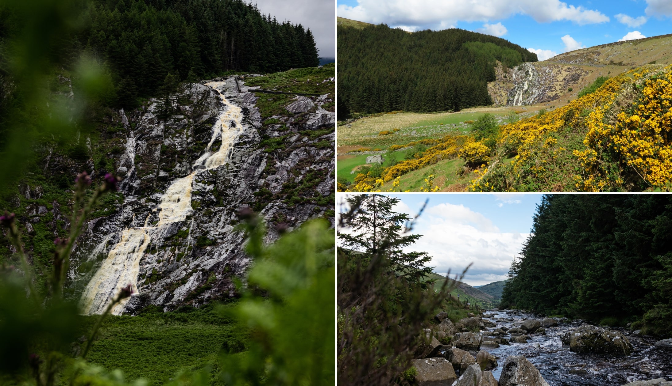
Photos via Shutterstock
Our second last stop on the Sally Gap Cycle / Drive is Glenmacnass Waterfall. As you drive along Old Military Road, keep an eye out for a car park on your right. Pull in here and hop out.
You should immediately be greeted by the sound of a stream. Walk along Military Road (stay very close to the little grassy verge and keep an ear out for oncoming cars) for around 40 seconds and the waterfall will come into view.
This is a grand little spot to kick-back for a while. There’s a fine view out over the valley and there are plenty of little places to sit and admire the scenery that lies before you.
Stop 6. Coffee and food
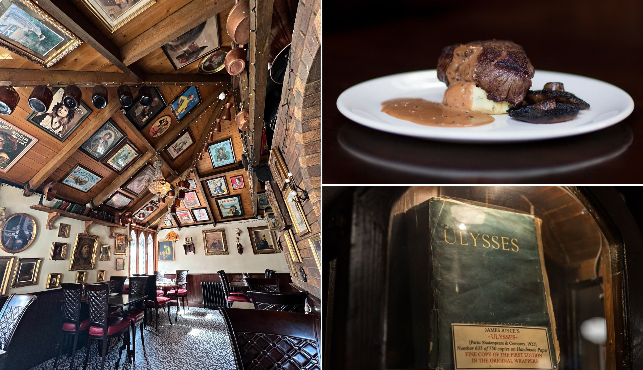
Photo left: The Irish Road Trip. Others: Via Wicklow Heather
The final stop in our Sally Gap Drive guide is the Wicklow Heather. If you’re feeling peckish or if you just fancy a coffee, this is a handy drive from Glenmacnass.
It’s also a ridiculously cosy spot, which makes it the perfect hideaway for those of you visiting during the colder months and looking to warm up.
Another good option for food is the nearby Coach House in Roundwood. If you visit during the winter you can expect a roaring fire and a hearty feed.
Sally Gap walks

So, there are an almost endless number of different Sally Gap Walks that you can try. However, 3 stand out above the rest, in my opinion:
- The Lough Ouler Hike: Starts from the car park at Glenmacnass or from the other side at Turlough Hill Car Park
- The Djouce Mountain Walk: Starts from the JB Malone Car Park
- The Lough Tay to Lough Dan walk: Starts from 1 of the 2 car parks near the lake
Djouce is arguably the handiest of the Sally Gap walks while Lough Ouler tends to be the trickiest, as there’s no trail for a good chunk of it.
If you fancy venturing further afield, you’ll find plenty walks in Glendalough to tackle, from short and sweet to long and tough.
The Sally Gap cycle: A warning

Photos via Shutterstock
So, I’m adding a section to this guide for those of you debating doing the Sally Gap cycle… Just 5 days after my uncle came off his bike while coming down the hill near Lough Tay.
He was coming down an incline and managed to lose control at a bend. He broke his collar bone and 3 ribs – he was blessed to get out of it without any life-changing injuries.
Wear a helmet, be aware of the sudden declines and, unfortunately, be aware that you may encounter some unsavoury characters.
There have been a number of reported incidents of cyclists being attacked while doing the Sally Gap cycle on their own. If you’re planning a Sally Gap cycle, be vigilant and travel in pairs where possible.
FAQs
We’ve had a lot of questions over the years asking about everything from ‘What is Sallys Gap?’ to ‘Is this the same as the Wicklow Gap?’.
In the section below, we’ve popped in the most FAQs that we’ve received. If you have a question that we haven’t tackled, ask away in the comments section below.
How long is the Sally Gap Drive?
The popular Wicklow Mountains scenic drive measures 26 km/16 miles in length. It would take you 1 hour to drive it, without stops, and around 1.5 to 2 hours with stops.
Where does the Sally Gap start?
The actual Sally Gap in Wicklow is a cross-road a short drive from Lough Tay. The driving/cycling route can be started in either Roundwood or Laragh.
How high is the Sally Gap?
The Sally Gap sits at 1,640ft (500m) above the sea level and its one of the highest mountain passes in Ireland.
Is the Wicklow Gap or the Sally Gap more scenic?
The Sally Gap Drive is a much more scenic route than the Wicklow Gap. The Wicklow Gap connects Dunlavin to Glendalough.
Keith O’Hara has lived in Ireland for 35 years and has spent much of the last 13 creating what is now The Irish Road Trip guide. Over the years, the website has published thousands of meticulously researched Ireland travel guides, welcoming 40 million+ visitors along the way. In 2022, the Irish Road Trip team published the world’s largest collection of Irish Road Trip itineraries. Keith lives in Dublin with his dog Toby and finds writing in the 3rd person minus craic altogether.
Jane
Thursday 11th of September 2025
Thanks for this guide, we loved this route from Dublin to Kilkenny! Highly recommend!
Sarah K
Sunday 7th of July 2024
This drive was everything and then some. Thank you for the spectacular guide!
Janet
Wednesday 12th of June 2024
Is driving the Sally Gap Drive feasible in a campervan (think Amazon delivery van size) without too much trouble? And we're unable to start early in the day, and it'll be a Saturday. But might towards the end of June be fairly quiet? It sounds divine.
Keith O'Hara
Wednesday 12th of June 2024
Hi Janet - I think (can't be 100% sure) that size of vehicle should be fine. I was just looking at the section of road near the ps I love you bridge, as that's narrow, but I've encountered small tour buses here, so I think (again, not 100%) you should be fine.
Beth
Saturday 27th of November 2021
Can you do this route by starting at Sally Gap (coming from Bray) then down and around? Or is it better to start at Roundstone (just a bit out of the direct path from Bray)
Keith O'Hara
Monday 29th of November 2021
Hey Beth - the last time I did this drive I did it from the opposite side (the one you'll be doing if coming for Bray) and it was great, too! I just prefer it from Roundstone as you get views out over the valley before Lough Tay. Enjoy your spin!