
Lough Tay (Guinness Lake): Walks, Viewpoints + Map
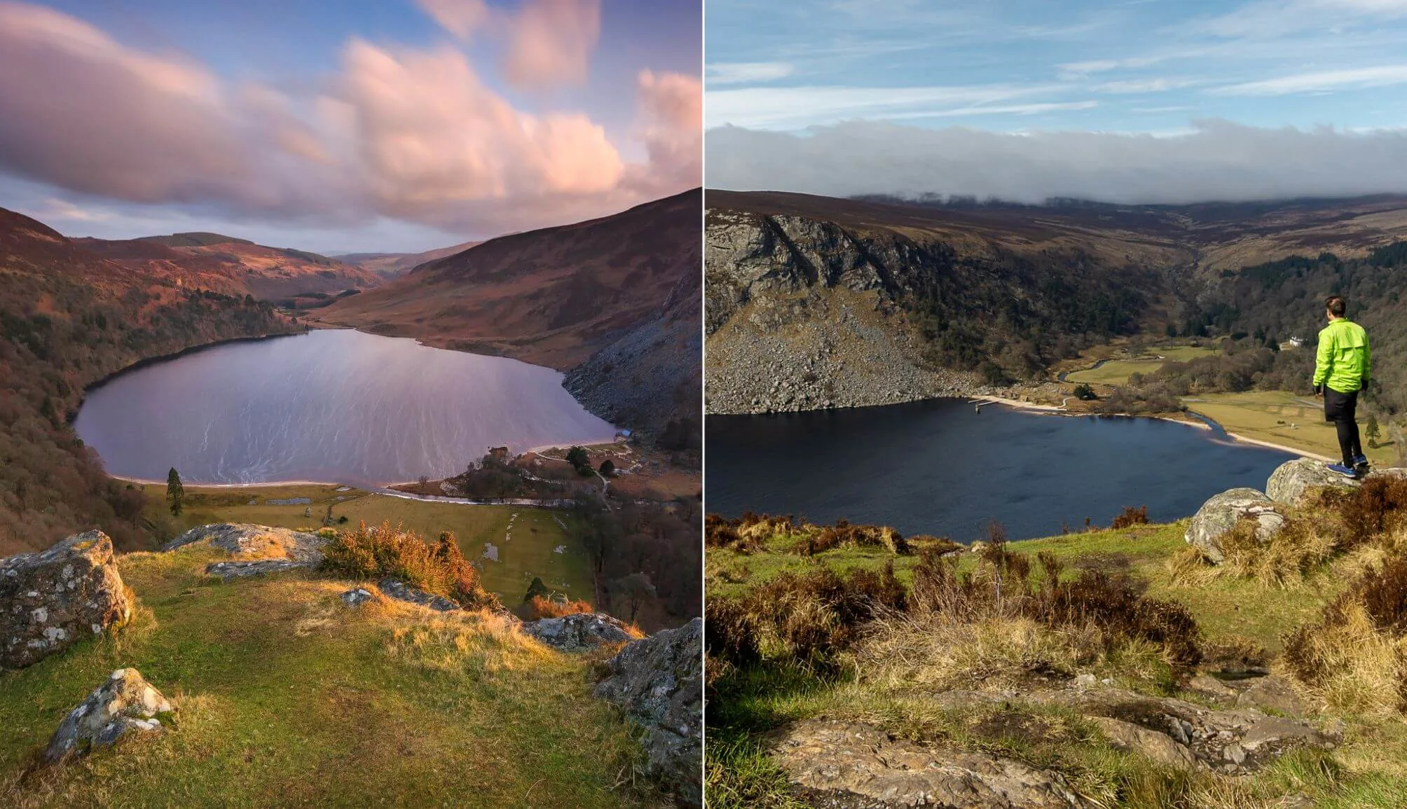
Located along the Sally Gap Drive, Lough Tay – nicknamed ‘Guinness Lake’ due to its dark waters and white shoreline – looks uncannily like a freshly poured pint. It’s one of Wicklow’s most visited attractions, and for good reason.
Popular with film crews (Vikings, Excalibur, and Irish Wish were all filmed here), Wicklow’s Guinness Lake is off-limits to visitors, as it sits on private land owned by the Guinness Family Trust.
Below, you’ll find a maps with the viewpoints, the different Lough Tay hike options and what to see nearby.
About Lough Tay aka ‘Guinness Lake’

For the most part, a visit to Guinness Lake in Wicklow is fairly straightforward, however, there are a few need-to-knows that’ll make your trip more enjoyable.
1. Location
You’ll find Lough Tay in the Wicklow Mountains where it’s nestled between Djouce Mountain and Lugga. The Guinness Lake, as it’s known, is situated within a private estate, but it can be viewed from above from several viewing points (map below).
2. Why it’s called Guinness Lake
Lough Tay is nicknamed the Guinness Lake because it sits on the Guinness family’s private estate and, from above, its dark waters and white-sand shore resemble a pint of stout.
3. The Lough Tay car parks
So, there are several different places for parking at Lough Tay, with each one situated by/near viewpoints and/or trailheads. Scroll down for a map of the parking areas.
4. Getting there without a car
If you want to visit on a day trip from Dublin and you don’t have a car, you can take the Dublin to Glendalough bus and get off at Roundwood. It’s a steep 1.5 hour walk from the village (note: there are no paths). You could also take this 1/2-day tour from Dublin that passes Lough Tay.
The Lough Tay viewing points

There are several great Lough Tay viewing points along the first leg of the Sally Gap Drive. Now, a couple of warnings. Firstly, some of these viewpoints are on private land – we’re not telling you to enter this land.
Secondly, many of these viewing areas have very sheer drops that can come upon you out of nowhere. Extreme caution is required.
Viewpoint A

The first Guinness Lake viewpoint is from the area across the road from the Ballinastoe Woods parking area (here on Google Maps). Now – there’s private land across the road. Although I’m not telling you to go onto this land, if you did, you’d have a view out over the lake. Extreme care would be needed here as there’s a very steep drop.
Viewpoint B
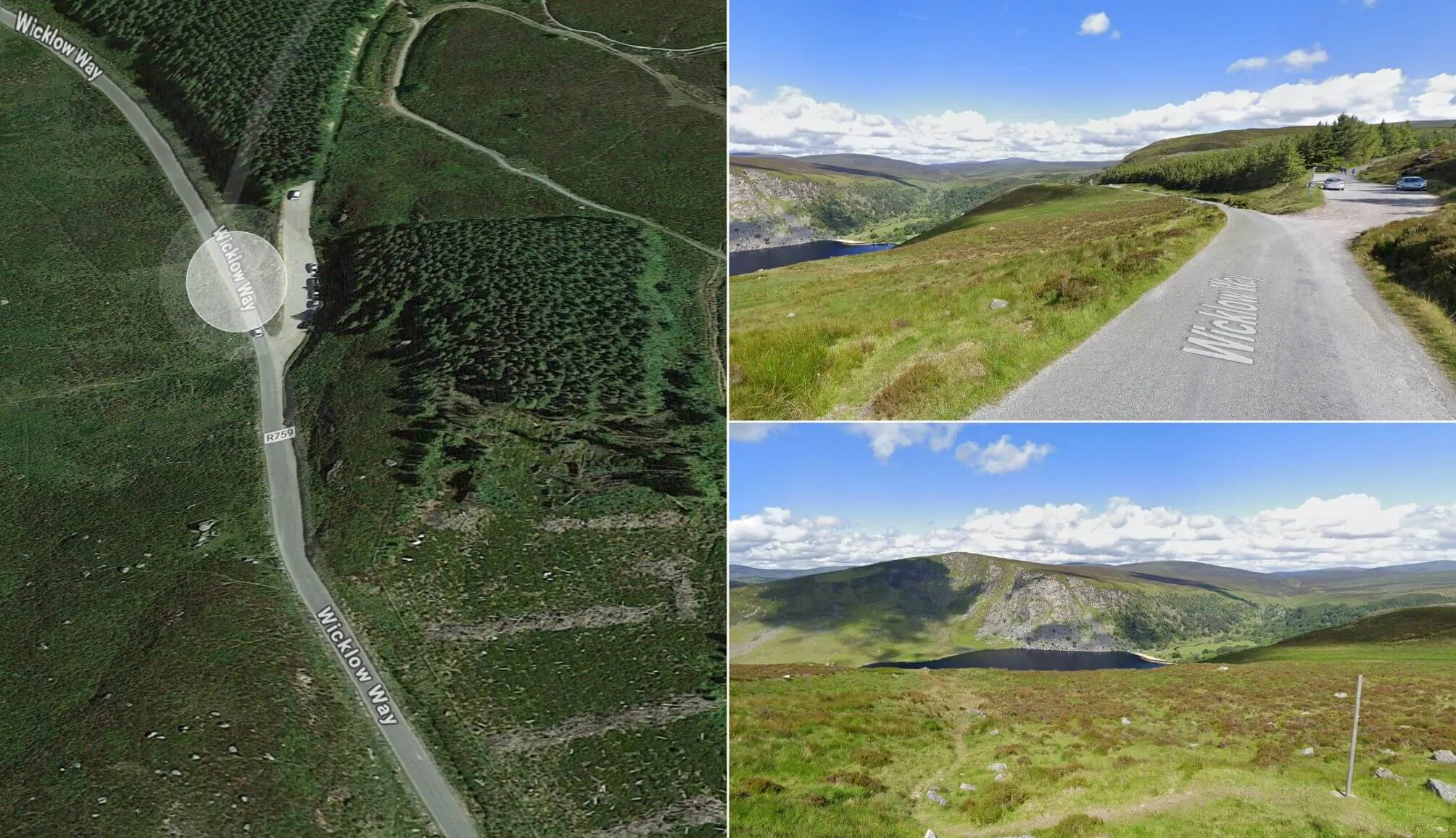
The second spot is arguably the best of the Lough Tay viewpoints, as you car park up and get an eyeful, as the site is elevated (here on Maps). This can be a hard spot to get parking, however, as it’s the starting point for Djouce, one of the most popular hikes in Wicklow.
Viewpoint C

The third Lough Tay car park is the JB Malone Car Park (here on Google Maps). Again, there’s an area across the road that’s privately owned that you could (remember – I’m not telling you to!) get a view from.
Viewpoint D

The final Lough Tay viewing point is arguably the one that’ll be suitable for most (here on Google Maps) as you don’t have to go near private land. You park up and the view out over the lake is clearly visible right from where you pull in (on the right if you’re approaching from Roundwood).
The Lough Tay hikes

If you’re visiting the area and fancy trying the Lough Tay walk, there are several routes to choose from of varying lengths.
In this guide, I’ll take you through the walk from Lough Tay to Lough Dan, the Luggala hike along with nearby Djouce Mountain Walk, where you’ll get great views of the lake from above.
1. The Lough Tay walk to Lough Dan (easy)
The short Lough Tay walk is an 8km linear trail that takes around 1.5 hours in total. It starts from the kissing gate opposite Ballinastoe Woods car park (here on maps).
Follow the road downhill, turn left at the white cottage with the red Lough Dan sign, pass the farm and then cross the two small bridges.
The road ends after the second bridge. From this point, you need to look for the rugged old stone wall – you follow this for the remainder of this version of the Lough Tay walk (see map above).
2. Djouce (moderate)

The second Guinness Lake walk takes you away from Lough Tay and up Djouce Mountain. This is a moderate, 6.5km/2-3-hour hike that treats you to glorious views from its summit.
So, why does it also get lumped in as a Lough Tay hike? Well, when you’re a bit of the way into the walk, you can soak up mighty views of the lake itself.
3. The Luggala Lough Tay hike (difficult)
The third Lough Tay hike rewards you with one of the best views of the inky-black lake below. This is the Luggala hike, a tough 2.5 to 3-hour climb that’s worth the effort if you’re well prepared.
Start as you would for the Lough Tay to Lough Dan walk, but take a right instead (see map). The ascent is steep and demanding, and once at the top, keep well back from the cliff edge – it’s a sheer drop
About Luggala Estate

Although you can’t get down to the lake, you’ll see the impressive estate from many of the viewpoints. Luggala Lodge was built in 1787 and, according to the official website, ‘gothicized thereafter for the La Touche family‘ (Dublin bankers of Huguenot origin).
Many years later, in 1937 Ernest Guinness, the second son of Edward Guinness (the head of the Guinness brewing business) bought Luggala and gave it as a wedding present to his daughter.
Now that’s some present… look at the size of the place! Over the years the estate has played host to everyone from Brendan Behan and Seamus Heaney to Mick Jagger and Bono.
The landscape at Luggala is picturesque and dramatic, which is why it has and it became a magnet for Hollywood over the years. The estate has been used in the filming of multiple movies, such as;
- Sinful Davey
- Zardoz
- Excalibur
- King Arthur
- Braveheart
- Becoming Jane
- P.S. I Love You
What to do nearby

One of the beauties of the Guinness Lake walk is that it’s a short spin away from some of the best things to do in Wicklow.
Now, you’re best off following the Sally Gap Drive from the lake (see map above). Some nearby attractions include:
- Glenmacnass Waterfall: 25-minute drive
- Powerscourt Waterfall: 20-minute drive
- Victor’s Way: 10-minute drive
- Lough Ouler: 30 minutes to the car park
- Glendalough: 25-minute drive (there’s loads of Glendalough walks, like The Spinc)
Keith O’Hara has lived in Ireland for 35 years and has spent much of the last 13 creating what is now The Irish Road Trip guide. Over the years, the website has published thousands of meticulously researched Ireland travel guides, welcoming 40 million+ visitors along the way. In 2022, the Irish Road Trip team published the world’s largest collection of Irish Road Trip itineraries. Keith lives in Dublin with his dog Toby and finds writing in the 3rd person minus craic altogether.


IF YOU JUST WANT TO VIEW THE LOUGH FROM ABOVE IS IT A LONG HIKE FROM THE CAR PARK
Hi Mark – there’s a car park (little pull in area) on the right if you’re approaching from the Roundwood side. It takes seconds to cross and get the view you’ll see in many of the pictures in this guide.
We brought my Nan here recently enough and she had no bother getting across to the part where you get the view pictured. The only tricky part was the little knee height wall, but this shouldn’t cause an issue for most.
Is it true that the pier gates and access to Luggala and Knocknaclockogue has been closed to hikers recently?
Hi Ray – I’ve heard that alright but I can’t seem to find any updated info online around whether they’re open yet/what the current status is, which isn’t ideal!
Hey Keith !
Want to do the Lough Tay hike tomorrow but in All Trails app it’s not coming up … so we park as per your article ? Does the walk you describe take you up to Lough Tay and then onto Lough Dan and back again ? Bit confused ..
Cheers
Bernie
Hi Bernie – there’s a lot of reports that one of the gates that you need to use for this walk is currently closed. I can’t find any ‘official’ info online, but there’s been chatter in some travel groups that it’s closed until the end of the month (I haven’t been able to confirm).
This is the answer you’re looking for, I know!
Hi Keith,
I am planning to visit lough tay on Saturday. can we go down just for sitting next to water? I know it is private property can we still go down to take some photos and chill ?
Hey Abhi! No, you can’t go anywhere near Lough Tay, as it sits within a gated estate on private land. The closest you can get is from the viewing point above, which is still a nice spot to sit an chill!
Enjoy your visit!
We just went up today! Searched the luggala bike carpark which has spots for maybe about 7 cars and is past the viewing point mentioned. We crossed the road and headed straight, following a slight trail in the heather and also 2 other hikers! Upon reaching the highest peak straight ahead you come up over it and have a birds eye view down onto the lake- was beautiful. On the way home we then stopped at the grassy viewpoint which gave us another point of view! Stunning location- pity the estate is private property now
Both Luggala and Ballinrush Estates have been privately owned since the 18 th century at least. Between the La Touche and then Powerscourt families in the early days and since the 1850s Ballinrush has been in The Archer family, while Luggala sold to The Guiness Family in 20th century until the Hon Garech Brownes sojourn there ended. Both are areas of special scientific interest and need folk to understand that this places a burden on all the owners to care and conserve the unusual unspoilt areas , hence trying to restrict access over sensitive areas . There are health and safety restrictions as certain areas can be dangerous as well and this leads to restrictions too. Both of these sets of owners spend time here and appreciate some privacy as well, particularly since The Avenue at Ballinrush is merely access for the owners and not a right of way at all.
Hi Keith! Is there a bus from Dublin which leads you close to the lake? If yes which one and which stop? Thank you!
Sorry for the delay in getting back to you Beatrice! You could get the glendalough bus from dublin to Roundwood – it’s a 1.5 hour, and very steep, walk from there up to Lough Tay though. I hope this helps!
Hello, thanks for all the wonderful places to visit ! Do you think that we can easily do the Wicklow area without a car or maybe we should focus on some “main” sites ? Thanks a lot !
Hey Manon – Unless you’re willing to do an awful lot of walking, I’d say you’re best off sticking to the main sites. Walking the Sally Gap, for example, would be a long, steep treak. Sorry it took so long to reply!