The Spinc in Glendalough is outstanding.
The Spinc is a ridge that overlooks Glendalough Valley and many of the more popular Glendalough hikes take you up to it.
The short Spinc Walk follows the blue arrows while the long Spinc Trail (the one we’re focusing on here) follows white arrows.
Below, you’ll find everything from where to park and what to expect to a map outline this route for exploring the Spinc in Glendalough.
Some quick need-to-knows about the Spinc in Glendalough
Photos via Shutterstock
The Spinc Loop (aka the Glendalough White Route) is a superb walk that’ll test your mettle and reward you with incredible scenery at every turn. Here’s what you need to know:
1. Location
You’ll find the Spinc in Glendalough, about an hour or so from Dublin City Centre, making it an ideal spot for a day out of town. It’s also nestled in the Wicklow Mountains National Park and guarantees superb scenery. The nearest village is Laragh and if you’re coming from Wicklow Town, it’ll take about 30 minutes to drive.
2. Parking
You’ll find two car parks at Glendalough, the upper and lower. Both are large and the Upper car park also boasts two food trucks and a toilet. There’s a €4 fee for cars (all day) and €15 for motorhomes. For this walk, the Upper car park is closest to the trailhead, but if you don’t mind adding an extra 30 minutes or so, you can use the Lower car park and enjoy the Glendalough Monastic City along the way.
3. Length + Difficulty
The Spinc Loop takes you on a 9.5 km ramble with some steep inclines and tricky paths. There’s some steep climbing and over 600 steps near the start, but after that, it’s a little more relaxed, though there are some tricky downhill sections later. It’s a moderate to strenuous walk, with a total ascent of 380 metres. If you’re in reasonable shape, you should be okay and most people complete the walk in just over 3 hours.
4. Recent works
Recent trail works replaced older timber boardwalk sections with stone pitching and gravel, improving drainage and grip in wet conditions. The steep climb remains, with many steps now built in stone rather than wood, making the route more durable but tougher on the legs.
5. The argument for which direction to walk it
In this guide, I recommend starting the hike from above the visitor centre. I prefer getting the steep climb done early, then enjoying a more relaxed walk for the rest of the trail. That said, starting from the Upper Lake also makes sense if you want a steadier climb and longer, front-facing views.
About the Spinc trail

Photos via Shutterstock
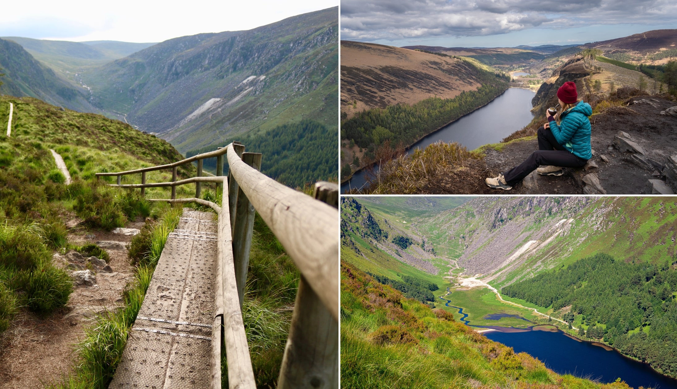
The Spinc Walk isn’t the longest of the many hikes in Glendalough, but it’s arguably the most well-known for its impressive views over the lake and surrounding valleys.
The Spinc is the name of the hill and it comes from Irish, An Spinc, which means pointed hill. This is a fair description and the pyramid-like hill requires some steep climbing to conquer.
A lot of the Glendalough White Route follows a wooden boardwalk along the top of the cliffs that line the southern shore of the Upper Lake before it drops down into a blanket bog.
Further on, you’ll descend into the Glenealo Valley, a serene and picturesque area home to deer and wild goats.
Once you make your way back into Glendalough Valley, you’ll arrive at the miners village, before following a flat path along the northern shore of the Upper Lake and back to the car park.
A tough but rewarding ramble, this is one of our favourite hikes in Wicklow for good reason.
An overview of the Glendalough White Route

The Glendalough White Route officially starts at the Upper car park and from there it’s pretty easy to follow, just look for the white arrows.
If you prefer to start at the Lower car park and see the monastic site first, simply follow signs for the Green Road Walk leading you to the Upper Lake and car park.
Excellent signage makes it difficult to get lost, so we’ll just go over what to expect along the way.
Kicking things off

Photos via Shutterstock
You start the Spinc Walk from the Upper car park, head to the Glendalough Visitor Centre to pick up a free printed map of the area and all of the routes. You can follow the loop in either direction.
Clockwise starts with more climbing and a lot of steps, while anti-clockwise will require more scrambling up rocky inclines, ending with a lot of steps back down.
The choice is yours, but in this guide, we’re doing the Spinc Walk clockwise as it gets you to the viewpoint quickest!
From the visitor centre, follow the white arrows and signs for Poulanass Waterfall. You’ll soon see the beautiful cascade as it crashes down through the surrounding oak forest.
Continue up the path until it splits, and take a right.
The steep climb to the ridge

Photos via Shutterstock
This is the toughest part of the Spinc Loop. After leaving the main track, the trail steepens quickly as you climb through forest and onto the hillside.
Many of the old wooden steps have now been replaced with stone-built steps and pitched paths. The ascent is still a lung-burner, but footing is more secure than it once was.
Once you crest the ridge, the gradient eases and the views open dramatically.
Down in the valley

Photo via Shutterstock
After topping the ridge, the Spinc Walk gradually begins to descend away from the cliff edge and into Glenealo Valley.
Keep your eyes peeled here, it’s not uncommon to see deer, wild goats, and even peregrine falcons.
As you go, the boardwalk disappears and turns into a rocky section of the Spinc loop. Soon enough, you’ll cross a bridge over the Glenealo River.
Now, a warning – this is where the Spinc Walk can get dangerous if you’re visiting on a wet day – the rocks here can be very slippy, so please take care!
After the bridge, it gets pretty rocky, with a path that zig-zags down to the valley floor. Good boots are a must here as it can be a real ankle twister if you’ve not got support.
The Miners Village and home

Photos via Shutterstock
Once you reach the bottom you’re on the final leg of the Glendalough Spinc walk, and it’s relatively easy-going from this point onwards.
You’ll find yourself surrounded by the ruins of old stone buildings and rusty machinery.
Once you’ve finished exploring, you’ll follow a wide, flat path (the Miners Road Walk) along the northern shore of the Upper Lake, with a forest of Douglas Firs to your left.
Finally, you’ll arrive back at the Upper car park, ready for some well-earned refreshments!
Things to do after the Spinc trail
One of the beauties of the Spinc in Glendalough is that it’s a short spin away from many of the best things to do in Wicklow.
Below, you’ll find a handful of things to see and do a stone’s throw from the Spinc Trail (plus places to eat!).
1. Post-hike Food
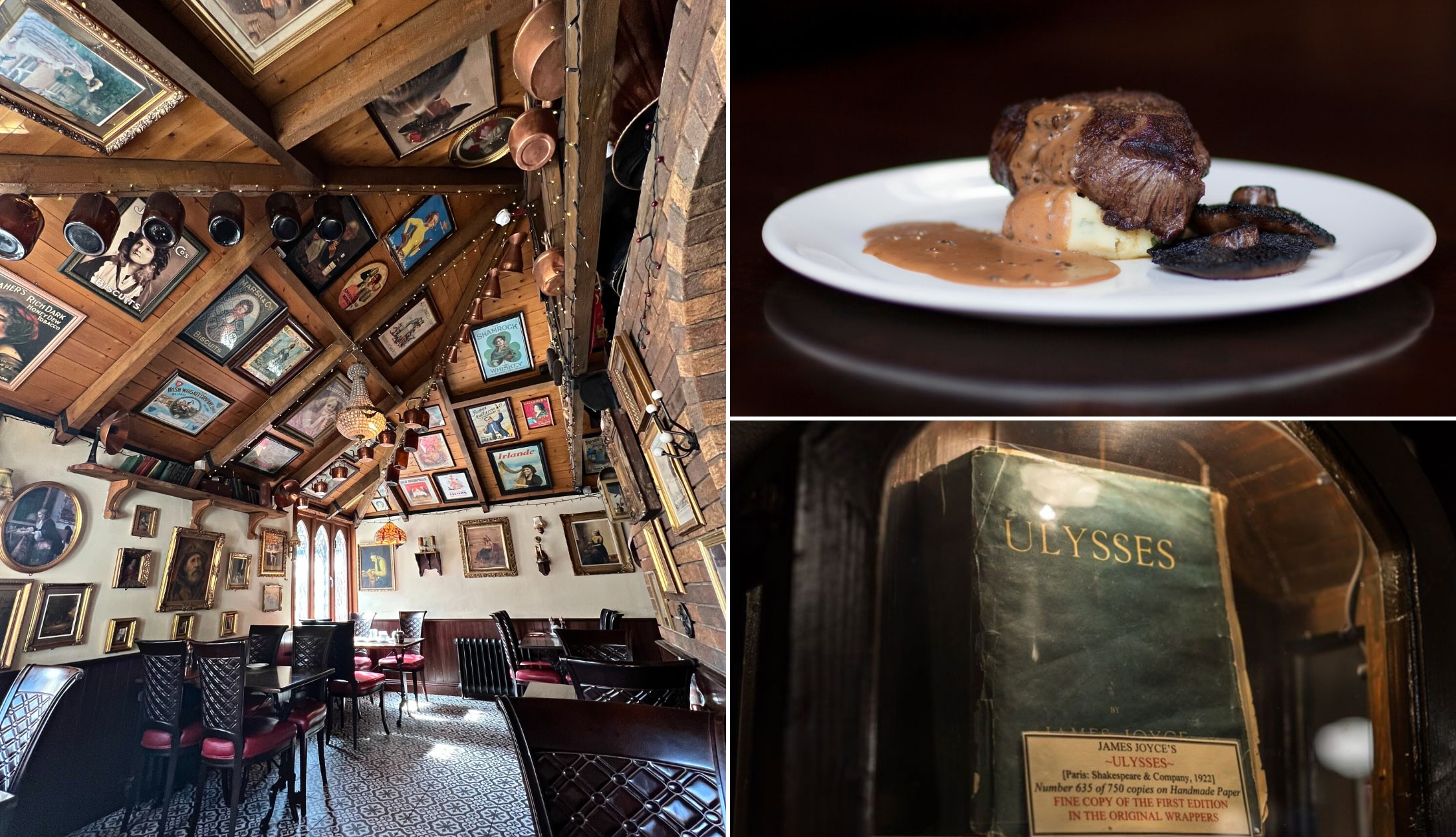
Photo left: The Irish Road Trip. Others: Via Wicklow Heather
Conquering the Spinc in Glendalough will have you hankering for a feed. If you’re ready to leave the area, nip over to Laragh where you’ll find some great pubs, cafes, and restaurants. The Wicklow Heather Restaurant is a personal favourite, with sumptuous food, a fantastic patio area, and a charming, Harry Potter-esque interior.
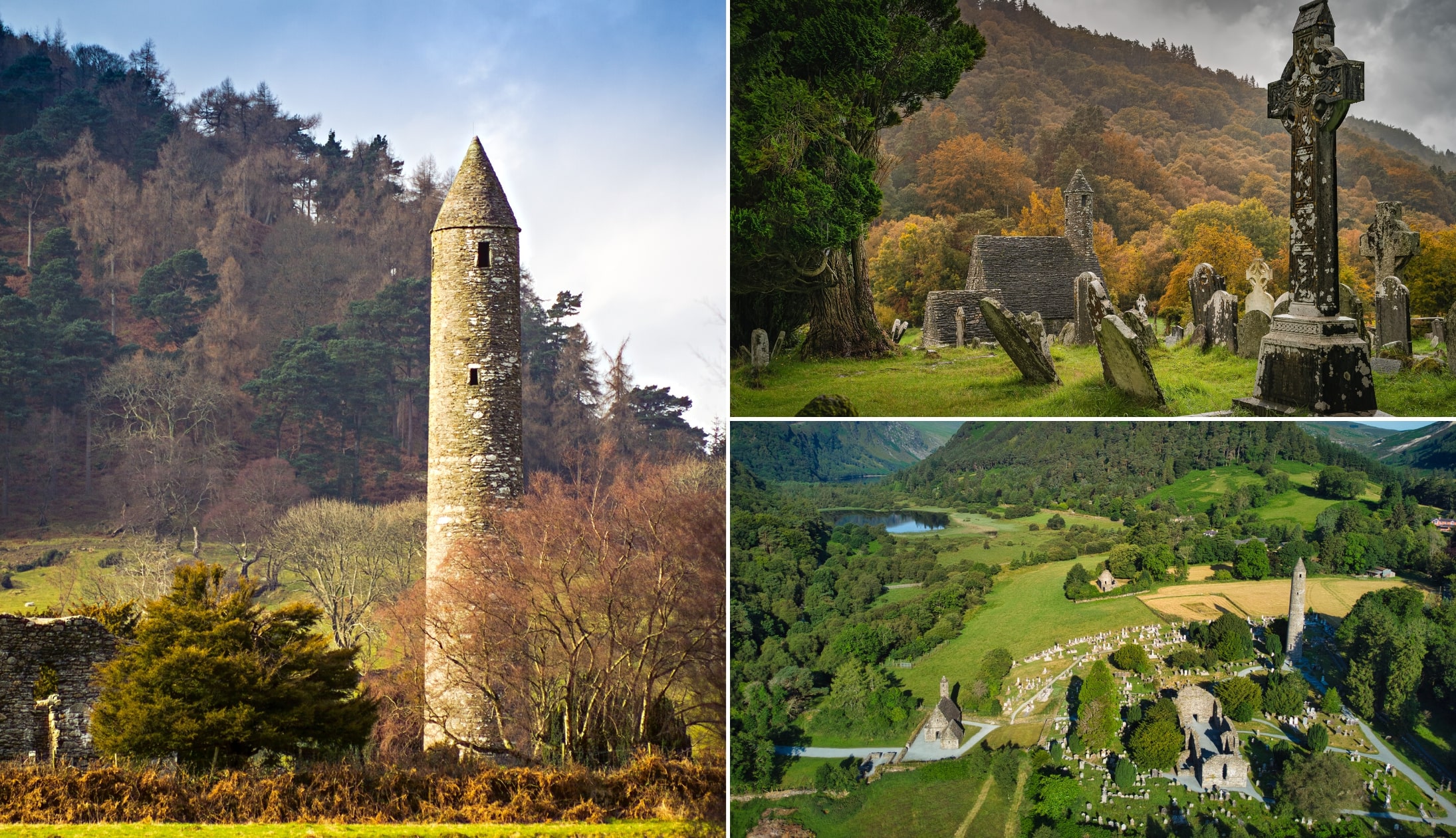
2. Glendalough Monastic Site
Photos via Shutterstock
After finishing the Glendalough White Route, head on over to Glendalough Monastery. Dating back to the 600s when it was founded by St. Kevin, it boasts some ancient ruins and relics. There are seven churches to explore, as well as the iconic Glendalough Round Tower, believed to be more than 1,000 years old.
3. Sally Gap Drive

Looking for the scenic route home after the Glendalough Spinc walk? The Sally Gap Drive takes you through some of the best scenery in the Wicklow Mountains. Following the Old Military Road from Laragh, you’ll drive up into the mountains until you reach Sally Gap Crossroads. From here, swing right down to Roundwood, past the mighty Lough Tay and its stunning surroundings.
FAQs about the Glendalough White Route
We’ve had a lot of questions over the years asking about everything from ‘Is the Spinc trail tough?’ to ‘What actually is the Spinc in Glendalough?’.
In the section below, we’ve popped in the most FAQs that we’ve received. If you have a question that we haven’t tackled, ask away in the comments section below.
How long is the Spinc Walk in Glendalough?
If you take the longer 9.5 km loop around the Spinc in Glendalough it’ll take you around 3.5 hours, depending on pace and stops.
Where does the Spinc trail start?
Officially, the Spinc loop starts in the Upper car park and then follows the white arrows up towards Poulanass Waterfall before leading you up along boardwalk.
Is the Spinc Walk hard?
You’ll need a moderate level of fitness to tackle the Glendalough White Route, as there’s some tough incline on the Poulanass side before you reach the top.
Keith O’Hara has lived in Ireland for 35 years and has spent much of the last 13 creating what is now The Irish Road Trip guide. Over the years, the website has published thousands of meticulously researched Ireland travel guides, welcoming 40 million+ visitors along the way. In 2022, the Irish Road Trip team published the world’s largest collection of Irish Road Trip itineraries. Keith lives in Dublin with his dog Toby and finds writing in the 3rd person minus craic altogether.