
The Glendalough Waterfall Walk (the Pink Route) is a nice short stroll.
And, while there is some incline at the beginning, it’s a good option if you’re short on time and don’t fancy exerting yourself too much.
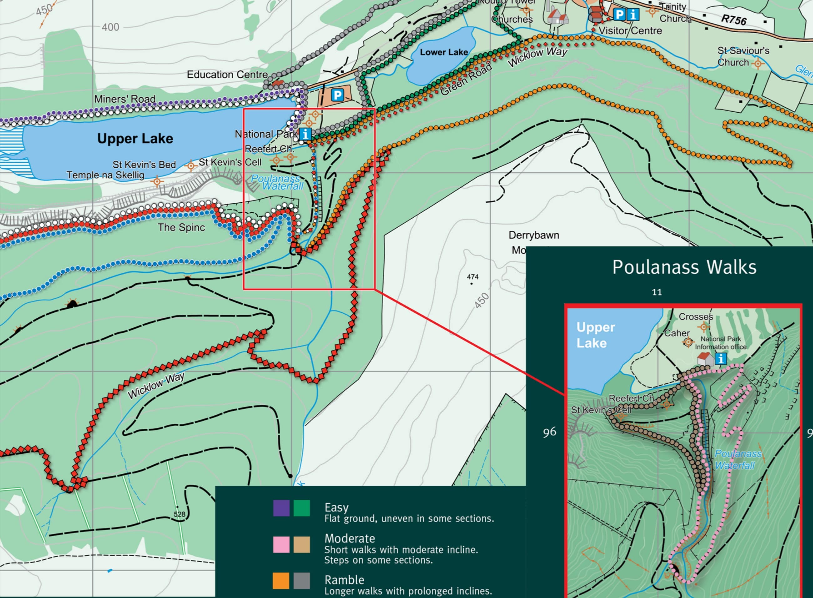
Below, you’ll find a map of the route along with what to look out for on the Poulanass Waterfall Walk.
About the Glendalough Waterfall Walk

Photos via Shutterstock
The Poulanass Waterfall Walk in Glendalough is easy enough to follow, with clear signs and well-maintained paths. Having said that, it’s worth taking a look at the basics before you set off.
1. Location
The Glendalough Valley is in the middle of the Wicklow Mountains National Park, near the village of Laragh. It’s about 25 km west of Wicklow Town and the drive will typically take about 40 minutes. Just 50 km south of Dublin, it’s around an hour’s drive from the capital.
2. Parking
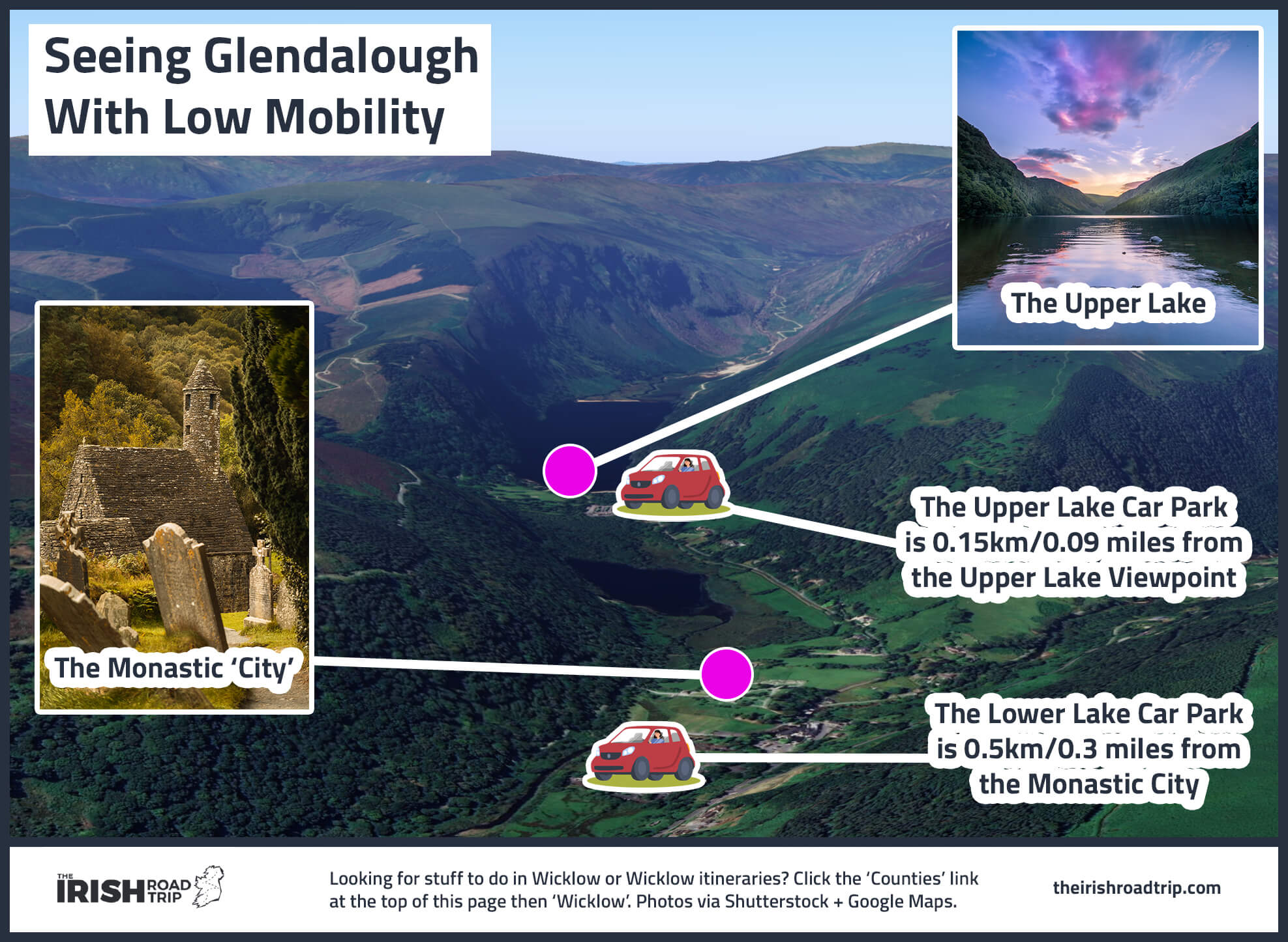
There are three main car parks at Glendalough; The Upper Lake Car Park has loads of spaces and marks the starting point for all of the walks in the area. You’ll also find clean toilets here, an information centre, and refreshments. It costs €4 for cars. The Lower Car Park costs the same and is closer to the main road, but it involves about 1.5 km of additional walking to get to the start point. There’s also a free car park in Laragh.
3. Length + Difficulty
The Poulanass Waterfall Walk isn’t overly long or difficult, covering a total distance of 1.6 km. There’s a pretty steep, but short, climb right at the start of the walk, which sees the trail rated as moderate. Anyone with a reasonable level of fitness should be okay though and the looped walk can typically be completed in around 45 minutes.
4. What to expect
The Glendalough Waterfall Walk follows a beautiful trail through mossy woods and grassy hillsides. Along the way, you’ll walk alongside a crystal clear stream as it splashes over the huge boulders that lay strewn all around.
An overview of the Glendalough Pink Route
Map with thanks to Wicklow Mountains National Park
The Glendalough Waterfall Walk is fairly easy to follow and you’ll find plenty of map boards at the car park and visitor centre detailing the routes.
In fact, you can normally pick up an A3 paper map for free as well. The route is well signed with pink arrows along the entire way.
Kicking things off
To get started, you’ll need to head towards the visitor centre in the Upper Lake Car Park. From here, you’ll see signs pointing to the waterfall and the pink waymarkers.
Follow the path up a short but steep incline and you’ll shortly reach the top of the waterfalls. There’s a viewing platform here, giving you a great look at Poulanass Waterfall from above.
Down into the woods
As you cross over the top of Poulanass Waterfall, the trail begins to descend into the gorgeous mixed woodlands and back to the valley floor.
This section is teeming with life, with a variety of birds to look out for, not to mention the wild goats that are often roaming the forest.
Looping back around
The moss-covered forest has a magical feel to it, and it’s a nice place to spend a little time enjoying the tranquillity, with the sound of the waterfall splashing in the background.
Soon enough you’ll arrive back at the Glendalough Visitor Centre, where you can perhaps start another walk through Glendalough.
Things to do after the Poulanass Walk
There’s plenty of things to do in Glendalough, and it just so happens that many of them are a short walk from Poulnass Waterfall.
Below, you’ll find the various hikes in Glendalough along with ancient sites and unique attractions.
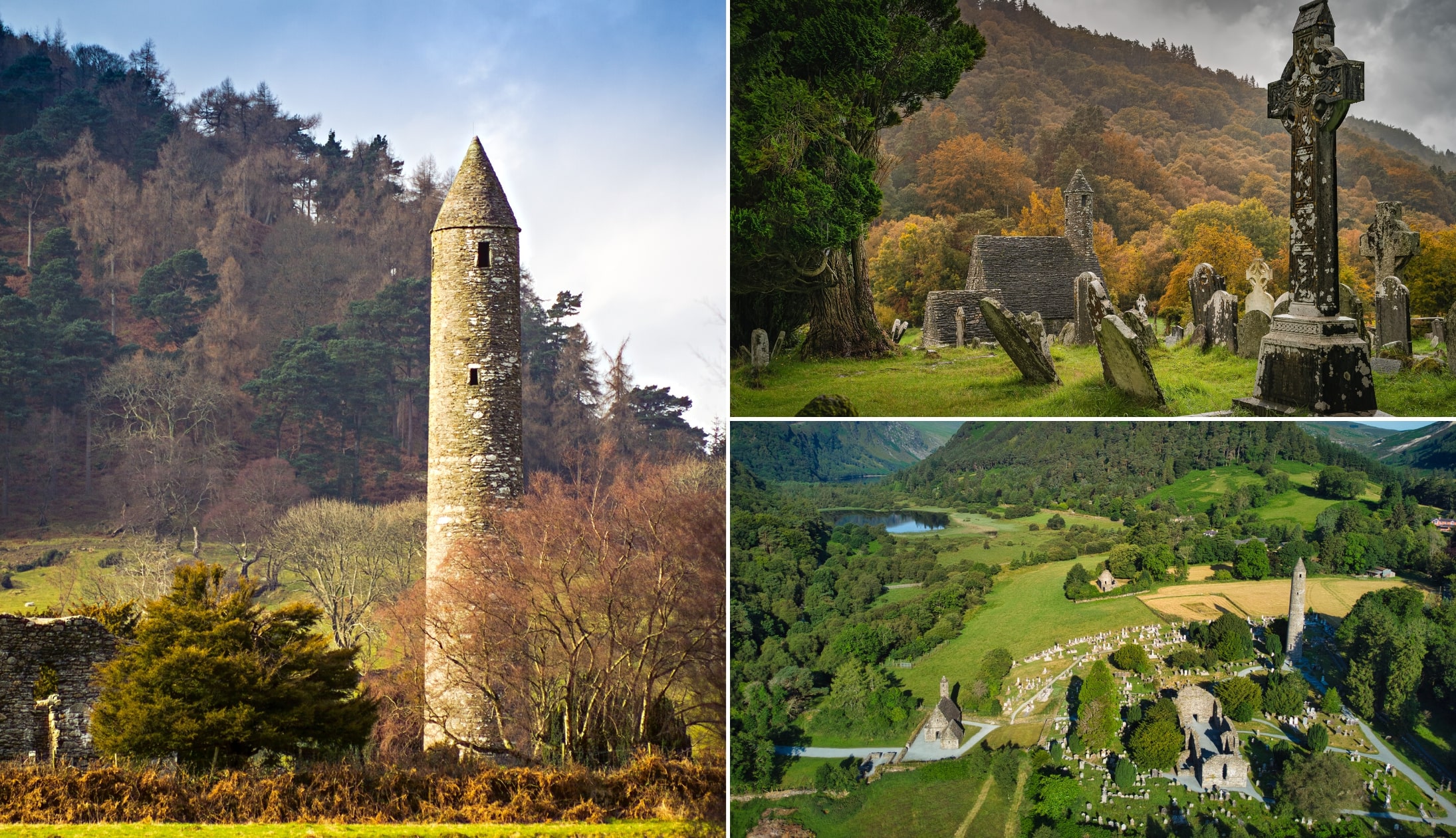
1. Glendalough Monastic Site
Photos via Shutterstock
Founded in the 6th Century by St. Kevin, Glendalough Monastery boasts countless ruins and tombstones, all surprisingly well-preserved.
It’s a fascinating place to wander around, taking in sights such as the mighty Glendalough Round Tower, which stands 30 metres tall and looks over the entire area.
A number of stone churches and carved granite crosses are dotted across the land, and you don’t need to be spiritual to feel a sense of peace here.
Visiting Wicklow? Check out our guide to the best things to do in Wicklow and our guide to the best hikes in Wicklow
2. Glendalough Upper Lake
Glendalough may be a haven for hikers, but it’s best known for its two impressive lakes.
The Upper Lake is the largest of the two and surrounded by steep, tree-covered slopes on both sides, it almost looks like a Norwegian fjord.
The water is crystal clear and there’s a small beach of sorts not far from the car park, an ideal spot for a picnic.
3. Sally Gap Drive

Sally Gap is an iconic Wicklow crossroad that’ll lead you to Dublin, Glendalough, Roundwood village, or Blessington, depending on which way you turn.
This circular drive (or cycle route if you’re up for it) is an amazing way to see some of the top attractions that the area has to offer, including Guinness Lake, blanket bogs, and the impressive Wicklow Mountains.
FAQs about the Glendalough Waterfall Walk
We’ve had a lot of questions over the years asking about everything from ‘How high is Poulanass Waterfall?’ to ‘Is the walk easy?’.
In the section below, we’ve popped in the most FAQs that we’ve received. If you have a question that we haven’t tackled, ask away in the comments section below.
How long is the Glendalough Waterfall Walk?
The walk up to Poulanass Waterfall in Glendalough stretches for around 1.6km and should take around 45 minutes, if you follow the trail above.
Is the Glendalough Pink Route tough?
The Pink Route isn’t particularly difficult, but it’s worth noting there’s a steep climb right at the beginning of the walk.
Keith O’Hara has lived in Ireland for 35 years and has spent much of the last 13 creating what is now The Irish Road Trip guide. Over the years, the website has published thousands of meticulously researched Ireland travel guides, welcoming 40 million+ visitors along the way. In 2022, the Irish Road Trip team published the world’s largest collection of Irish Road Trip itineraries. Keith lives in Dublin with his dog Toby and finds writing in the 3rd person minus craic altogether.