
The Slieve Gullion walk is well worth dedicating a morning too.
The Ring of Gullion is an Area of Outstanding Natural Beauty and Slieve Gullion, the highest mountain in County Armagh, sits at the very heart of it.
Hiking to the summit is a somewhat arduous, but ultimately rewarding, endeavour. This trail takes in varying landscapes, culminating in amazing views across the land.
Some quick need-to-knows about the Slieve Gullion walk

Photo via Shutterstock
Before you load up your backpack, let’s take a look at the basics, as they’ll save you time and hassle when you set off on the Slieve Gullion walk:
1. Location
Slieve Gullion sits in the southeast corner of Northern Ireland, in County Armagh. It’s about an hour’s drive from Belfast and an hour and a half from Dublin. The surrounding countryside boasts gorgeous scenery that takes in lakes, craggy hillocks, wild forest, and moody moors.
2. Parking
The Slieve Gullion walk starts at the main car park. It has space for around 120 cars, but during peak season it can fill up quickly since it’s the car park for a number of playgrounds, walking routes, and a cafe. The ‘top car park’ is higher up along the scenic forest road, and offers a quicker route to the summit.
3. Opening hours
Slieve Gullion Forest Park is open seven days a week throughout the year, closing only on Christmas Day. From April to early October it’s open from 8 am until 9 pm (or dusk depending on the time of year). From October to the end of March, it’s open from 8 am to 5 pm (or dusk depending on the time of year).
4. Length + difficulty
The Slieve Gullion walk is a looped trail stretches for 13.4 km (9.5 miles) and typically takes about four and a half hours to complete. With an ascent of 511 metres and occasional steep sections, paired with rocky and muddy sections, it’s a fairly moderate trek to undertake. Having said that, it’s a great challenge for anyone in reasonable fitness.
About Slieve Gullion

Photos via Shutterstock
Standing 573 metres (1,880 ft) tall, Slieve Gullion dominates the surrounding countryside and is the highest peak in County Armagh. It’s circled by a number of hillocks, collectively known as the Ring of Gullion.
An area of scientific interest, the Ring of Gullion is an ancient ring dyke, formed by the collapse of a volcano millions of years ago.
An area of natural beauty
The surrounding volcanic landscape offers rich diversity, with marshes and bogs in the low-lying areas, gorgeous woodlands on the eastern slope, lonely lakes, and barren slopes, dotted with purple heather, yellow gorse, and orange bracken.
Harsh and beautiful in its rawness, the mountain is home to a host of critters. Look out for the rare pine marten, otters, red deer, red squirrels, and buzzards.
An area of ancient history and legend
Slieve Gullion is steeped in myth and awash with ancient monuments including more than 20 stone tombs. Inhabited for more than 6,000 years, it’s got a magical atmosphere.
The Hunt of Slieve Gullion is one of the most well-known myths, in which the legendary Finn McCool is tricked into swimming in the enchanted lake atop the mountain by the witch Calliagh Berra.
He emerges from the water as an elderly man, and though his youth is eventually restored to him, his hair remains white forevermore.
An overview of the Slieve Gullion Walk
Since this is a looped route that starts and ends at the car park, you can complete the walk in either direction.
I prefer to go anti-clockwise to get in some attractions early on, before tackling the summit.
Starting the walk
This first section follows a few small country-lanes. Traffic is generally fairly light, but there’s not a lot of space on the road please take care.
From the Slieve Gullion Forest Park car park, follow the exit road and turn right at the T-junction onto Wood road.
The road heads downhill for around 500 metres or so, before reaching a crossroads. Turn left here onto Ballintemple road and continue forward, with the mountain on your left side until the wall of ancient trees hides the view.
Reaching Killeavy Castle
Soon you’ll pass Killeavy Castle Estate, a recently renovated ruined castle that now serves as a hotel and wellness centre.
After about 1.5 km you’ll come across the ancient, albeit somewhat damaged, Clonlum Cairn. After another 1.5 km, you’ll reach the iconic Killeavy Churches, well-preserved ruins that date back to the 10th century.
Surrounded by towering trees, it has a moody atmosphere.
Heading uphill
This is when the Slieve Gullion walk starts to get tough. After checking out the ruins, continue straight along Ballintemple road.
You’ll soon start climbing now so get ready for the workout. Enjoy the views of farm fields and hills to your right and when the road forks, take the left prong onto Ballard Road.
Follow the road up, and don’t forget to look back – the views over the countryside are spectacular. You’ll be treated to amazing sights from the Ballintemple Viewpoint, where you can see Cam Lough and the nearby Mourne Mountains looming in the background.
Follow Ballard Road for another 1.5 km or so until you reach Ballard Cottage, a small whitewashed bungalow. Opposite the cottage, you’ll see a gate and a grassy trail leading uphill.
Go through the gate and follow the path. It’s reasonably easy to follow for the most part, with the occasional signposts to help you along the way.
Continue heading up through barren, craggy slopes, and again, remember to look back every now and then!
Approaching the summit
As you near the summit, you’ll come across some ancient landmarks including the North Cairn of Gullion. This pile of rocks and boulders isn’t the summit just yet, though you’re not too far now.
Continue forward and the path becomes a little boggy as you approach the legendary Calliagh Berra’s Lough. This small body of water is popular in folklore and it’s still said that those who bathe in it will see their hair turn white!
The path is strewn with boulders as you approach the summit. When you reach the South Cairn, you’ve made it to the top of the Slieve Gullion walk! You’ll find the trig point and toposcope marking the peak, which boasts amazing panoramic views.
Here you can also find the highest passage tomb, known locally as Calliagh Berra’s house, in the British Isles.
Returning to the start
From the summit, you’ll see a small but well-defined track leading down the west slope of the mountain. It’s a little steep, and in wet weather, the rocks can be slippery so take care.
Make your way down all the way to the smooth tarmac of the forest road and the top car park.
Take a left at the road, and follow it down all the way back to the start point. Enjoy the amazing views that open up around you, including the surrounding hillocks, farmland, and distant towns.
Things to do near Slieve Gullion
One of the beauties of the Slieve Gullion walk is that it’s a short spin away from many of the best places to visit in Armagh.
Below, you’ll find a handful of things to see and do a stone’s throw from the mountain (plus places to eat and where to grab a post-adventure pint!).
1. Post-walk food (20 minutes +)

Photos via La Dolce Vita Pizza Burger Bar on FB
You’re sure to have built up an appetite after tackling the hike. Besides the cafe at Slieve Gullion Forest Park, there are plenty of great places where you can find a hearty meal. The town of Newry is brimming with pubs and restaurants that offer dishes from around the world.
2. Walks galore
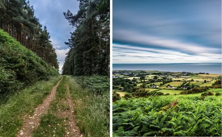
Photos via Shutterstock
If you’re up for more walking you’re spoilt for choice in this part of Northern Ireland. The gorgeous Ravensdale Forest is just a 20-minute drive away, boasting moody forest scenery and a magical atmosphere. Alternatively, the Annaloughan Loop Walk is a must, with a visit to Fitzpatrick’s Bar a great way to finish up.
3. The Mourne Mountains (35-minute drive)
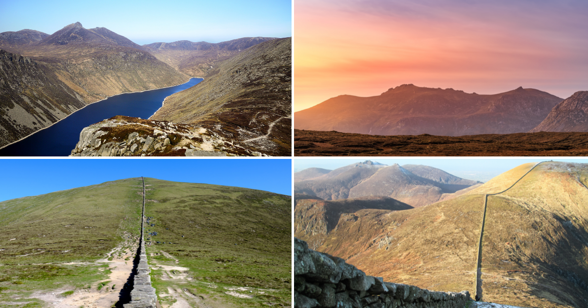
Photos via Shutterstock
The Mourne Mountains in County Down offer up many more walks that take in gorgeous views out to sea and the surrounding landscape. The extensive range is home to a wealth of different landscapes, with the tranquil Silent Valley, a host of forests, and cascading rivers to enjoy.
4. Carlingford (35-minute drive)
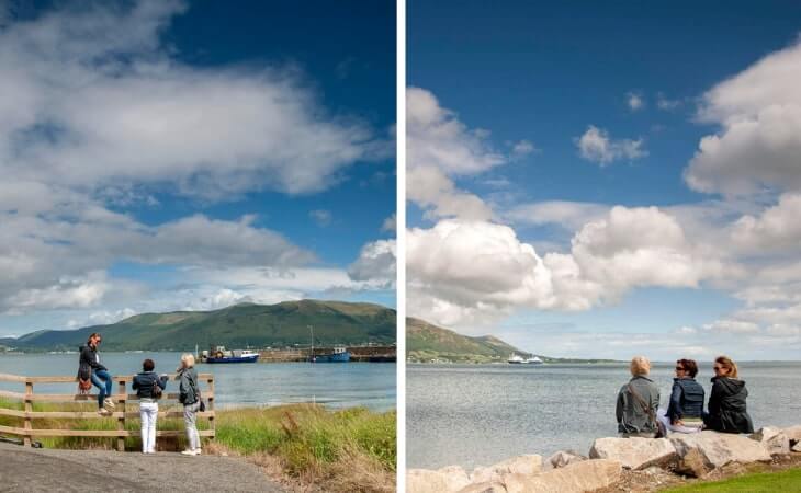
Photos by Tony Pleavin via Ireland’s Content Pool
A beautiful little town on the edge of the lough, Carlingford is full of attractions and things to see and do. From castles to leprechauns, every street corner boasts some kind of historic monument or curiosity. Plus, there are some cracking pubs and restaurants in town.
Slieve Gullion walks FAQs
We’ve had a lot of questions over the years asking about everything from ‘Are the trails tough?’ to ‘How long do they take?’.
In the section below, we’ve popped in the most FAQs that we’ve received. If you have a question that we haven’t tackled, ask away in the comments section below.
Is Slieve Gullion hard to climb?
The long looped Slieve Gullion walk is 13.4km (9.5 miles) in length and has some steep sections to tackle. Reasonable fitness is needed for this 4.5 hour trail.
Can you drive to the top of Slieve Gullion?
You can drive very high up the mountain (it’s a one-way system in place) where you’ll be treated to breath-taking views of the surrounding countryside.