
The incredible Wicklow Way walk is a long-distance trail that starts in Dublin, takes you through Wicklow and then finishes in Carlow.
The trail, which stretches for nearly 130km, takes walkers to some of the best places to visit in Wicklow and it’s best tackled over 7 to 10 days
Now, unlike some of the shorter hikes in Wicklow, the Wicklow Way walk requires a good bit of planning in advance, if you plan on doing it in one go.
In the guide below, you’ll find everything you need to know about each stage of the walk and you’ll find a Wicklow Way map at the end, too.
Some quick need-to-knows about the Wicklow Way Walk

Photo by Lukas Fendek/Shutterstock.com
The Wicklow Way trail isn’t overly straightforward, and adequate planning and preparation is required if you’re going to tackle it.
The guide below is intended to give you an overview of what to expect, but it’s no substitute for a solid map to follow along the way. Below, you’ll find some quick need to knows:
1. Where it starts and ends
Crossing the Wicklow Mountains, the Wicklow Way Walk is Ireland’s most scenic long-distance trail. This linear walk runs all the way from Dublin’s Marlay Park to the charming village of Clonegal in County Carlow.
2. Length
At around 130km in length, the Wicklow Way walk takes visitors on a 5-10 day journey through the Garden of Ireland aka County Wicklow.
3. Breaking it down
Now, you don’t have to do the entire trail all in one go, if you don’t have the time. You could easily tackle it over a few months by doing a couple of stages at a time.
4. What you’ll see on the way
Along the way, you will have an opportunity to discover some amazing scenery, including Guinness Lake (Lough Tay), Powerscourt Waterfall, and the beautiful monastic site of Glendalough.
5. The best time to do it
If you can, try and tackle the walk between April and September. The weather is generally better, the days are longer and the majority of the accommodation on the way will be running (some of it shuts during the off-season).
About the Wicklow Way Walk

Following the eastern side of the Wicklow Mountains, the Wicklow Way Walk is one of those trails that has it all. It is easily accessible, offers dramatic scenery, and has plenty of excellent accommodation options along the way.
This richly varied route consists of suburban parkland, quiet roads, picturesque forest trails, and scenic mountain paths.
Wicklow Way Map

Map via Sport Ireland
The Wicklow Way map above will give you an idea of the trail that you’ll be following if you give this route a bash.
As you can see, the 130km or so trail looks pretty daunting when seen it its entirety, bur when broken up into stages, it’s very doable.
An overview of the different stages of the Wicklow Way trail
OK – now it’s time to dive into the trail. Below, you’ll find a breakdown of each section of the trail from Stage 1 to Stage 7.
Remember, you can tackle these at your own pace. You’ll find accommodation options listed under each section, too. These are affiliate links – if you book a stay through them, we may make a small commission which we greatly appreciate.
Stage 1: Marlay Park to Knockree

Photo by Dux Croatorum (Shutterstock)
- How long it takes: 21 km/7 hours
- Difficulty Level: Strenuous
- Arrows: Marked with yellow marker poles
- Highest Point: 500m
- Recommended accommodation: Knockree Hostel
The Wicklow Way Walk starts in the suburbs of Dublin in Marlay Park. The first section of this trail takes you all the way from Marlay Park to Knockree.
Once you leave the city, you’ll be making your way past the lovely Kilmashogue Forest, Fairy Castle (part of the Ticknock Walk) and Tibradden Mountain.
After 3 – 4 hours, you’ll start the climb to Prince Williams Seat. After enjoying magnificent views of the mountains and the coast, take the path down to the Enniskerry road and on to Knockree.
Stage 2: Knockree to Roundwood
Photo by Lukas Fendek (Shutterstock)
- How long it takes: 20 km, 7 hours
- Difficulty Level: Strenuous
- Arrows: Marked with yellow marker poles
- Highest Point: 630m
- Where to stay: See Roundwood accommodation
Day two of the Wicklow Way trail is packed with scenery. The start of day 2 takes you around Knockree Hill (to the west) before descending and crossing the Glencree River.
This makes a nice little spot for a stop and a snack. Keep going until you reach the car park at Crone Woods. The next section is where comfy hiking boots come in handy. From the car park, you’ve a decent bit of hill to conquer.
However, you’ll be rewarded when you reach the top with views of the magnificent Powerscourt Waterfall. From here, you’ll keep rambling away until your reach the River Dargle. You’ve another incline to conquer here – the east side of Djouce Mountain!
If you have time (and energy…) the view from the summit of Djouce is worth the walk. After that, point your nose in the direction of White Hill. It’s from near here that you’ll begin your descent along the popular Ballinastoe Woods walk.
You’ll be treated to glorious views out over Lough Tay not long after. You’ve still a bit of way to go before reaching Roundwood, your base for night two.
Stage 3: Roundwood to Glendalough
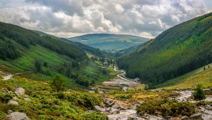
Photo by Stefano_Valeri (Shutterstock)
- How long it takes: 11 km, 3,5 hours
- Difficulty Level: Easy
- Arrows: Marked with yellow marker poles
- Highest Point: 360m
- Where to stay: See Laragh accommodation
Day 3 is much shorter than day 1 and 2, and it stretches for around 11km in length. The beauty of the shorter trail is that you’ve time to veer off track and explore some of Wicklow (or you could always tackle one of the Glendalough walks).
After leaving Roundwood, aim for the village of Laragh. You can stay here on night 3 or you can head on towards Glendalough.
Over the course of day 3, you’ll cross Paddock Hill before descending towards the Glenmacnass Road (unfortunately it’s a bit away from Glenmacnass Waterfall, but you can take the detour, if you like!).
For those of you staying in Laragh, you’re a short walk from the village. If you’re planning on kipping in Glendalough, you’ll want to head through Brockagh Forest before heading on to Glendalough.
Stage 4: Glendalough to Glenmalure

Photo by Falk-Photo (Shutterstock)
- How long it takes: 13 km/ 5 hours
- Difficulty Level: Moderate
- Arrows: Marked with yellow marker poles
- Highest Point: 560m
- Where to stay: The Glenmalure Lodge
Day 4 is my favourite section of the Wicklow Way trail. When you leave your accommodation, head off into Glendalough.
Keep an eye out for the Visitors Centre. You’ll want to aim for here before walking up towards the bustling Poulnass Waterfall before continuing on to Lugduff Valley.
There’s a tough uphill walk from here but you’ll find plenty of space to stop and relax on the way. After you reach level ground, you’ll be treated to some glorious views of the Valley.
Keep on strolling away and you’ll eventually begin your descent into Glenmalure Valley. You’ll be treated to more magnificent views during this section. Keep on going until you reach the now-iconic Glenmalure Lodge.
Stage 5: Glenmalure to Moyne

- How long it takes: 22 km, 7 hours
- Difficulty Level: Strenuous
- Arrows: Marked with yellow marker poles
- Highest Point: 520
- Where to stay: Moyne
Day 5 involves a good bit of walking (7+ hours), so try and get a decent bit of rest ahead of it. Day 5 kicks off with a walk through the woodland that sits on the lower slopes of Slieve Maan, before continuing on to the well-known Military Road.
After some time, you’ll meander your way up around Carrickashane. The trail then moves down to the Ox River Valley.
From here, you’ll continue across Ballyteigue Bridge before continuing on towards Moyne for the night.
Stage 6: Moyne to Shillelagh

Photo by by Pablesku (Shutterstock)
- How long it takes: 22 km, 7,5 hours
- Difficulty Level: Strenuous
- Arrows: Marked with yellow marker poles
- Highest Point: 480m
- Where to stay: Shillelagh
You’ve another lengthy day ahead of you on day 6. After leaving Moyne, you’ll follow the trail around Ballycumber Hill, before hitting Hacketstown.
Keep going and you’ll reach the bottom of Muskeagh Hill. From here, point your nose in the direction of the Dying Cow (a handy spot for some R&R and a bite to eat).
When you’re ready to rock, continue on towards Raheenakit Woods before making your way to Shillelagh for the night.
Stage 7: Shillelagh to Clonegal

Photo by Semmick Photo (Shutterstock)
- How long it takes: 20 km, 6 hours
- Difficulty Level: Moderate
- Arrows: Marked with yellow marker poles
- Highest Point: 350m
The final section and the last day of the Wicklow Way Walk starts at Shillelagh and takes you to Clonegal in Carlow.
On this stretch of the trail, you’ll be treated to gorgeous views of Mount Leinster. The trail leaves Shilleagh and takes you along relatively easy paths via Raheenakit Woods and past Stokeen, Moylisha and the Ureland Hills.
If you’ve managed to conquer the entire trail, fair play to you! It’s time to tackle the Dingle Way, next!
Patrick
Monday 7th of February 2022
Hi Norah, I'm trying to make my way from Clonegal to Glendalough in 4 days and then decide if I continue or finish the other half at another time I have a question I intend to use a tent on some stages can you pitch a tent along the way and if so just wondering do you have any known points/locations that could be recommended. Kind regards Patrick