
One of the biggest dilemmas people face when planning a West Cork road trip is trying to pick a ‘perfect’ base that 1, is a reasonable distance from all of the main attractions and 2, ensures you don’t need to change accommodation.
The reality is that West Cork is very spread out – no single town or village is positioned between all of the main sights in a way that allows you to avoid either long stints in the car or having to double back on yourself at the end of each day.
So, you’ve got 2 options if you’re planning on spending 3 – 4 days in West Cork:
- Change accommodation once: This’ll reduce backtracking/long periods in the car (what I’ll cover below)
- Stay in one place: And only explore a section of the region or accept that you’ll need to do some long drives
The West Cork road trip

As you can see from my West Cork road trip map above, I think the best approach is to pick 2 bases to explore from (this is based on a 4 night trip).
In my opinion, Glengarriff is a great base for the 1st 1/2 of the trip while Skibbereen ticks all of the boxes for the 2nd 1/2. Here’s some key info about this West Cork itinerary:
A: Alter the itinerary to suit your start point
The best way to use this itinerary is to adapt it to your own starting point. For example, let’s say you’re starting in Killarney: Drive to Kenmare, tackle the Ring of Beara and then head to Glengarriff for the evening and continue on from there.
B: There’s a mix of slow days and fast days
- Day 1: Assumes that you’ve driven a decent distance to get to Glengarriff, so there’s less than 40 minutes of driving needed
- Day 2: You’ll spend 3-3.5 hours driving the Ring of Beara with plenty of stops along the way
- Day 3: You’ll drive for 3.5 hours and cover a lot of ground with numerous walks and stops
- Day 4: Less than 2 hours of driving with several walks and plenty of stops
C: Why isn’t all of West Cork covered?
West Cork, similar to Donegal, is very spread out. You could easily spend a week here and still feel like you’re only scratching the surface. If you had an additional day, continue up along the coast to Clonakilty and then follow the road to Kinsale which, while not in West Cork, makes a great grand finale for your trip.
D: Where to stay
- Glengarriff: Casey’s Hotel (in the town) and Eccles (one of my favourites in Cork – short stroll from centre)
- Skibbereen: The West Cork hotel (in town centre) or Liss Ard Estate (luxury spot 7-minute drive from town)
Day 1: Glengarriff and its surrounds
Photos by Chris Hill via Tourism Ireland
Day 1 of this itinerary assumes that you’ll have needed to drive for a while to reach Glengarriff – the base for night 1 and 2.
For this reason, you won’t be driving much today – you’ll be spending the day exploring Glengarriff and it’s surrounds.
1. Glengarriff
Photos by Chris Hill via Tourism Ireland
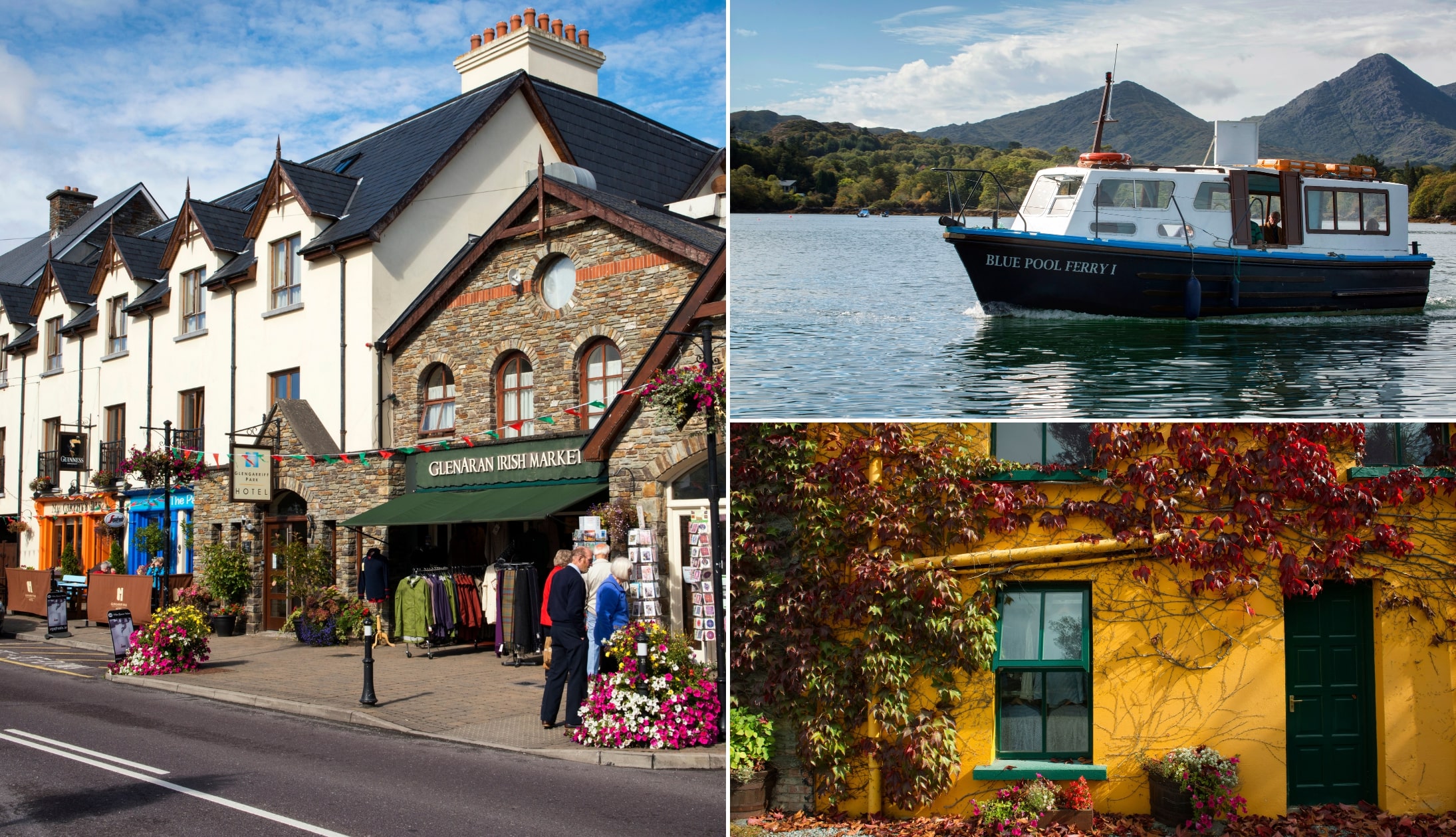
Your West Cork road trip kicks off in Glengarriff, a town that’s small in size but huge in character. With just 200 or so locals, it might seem like a blink-and-you’ll-miss-it village, but don’t let that fool you – Glengarriff is a gateway to much of West Cork.
Tucked between the Caha Mountains and Bantry Bay, Glengarriff gives you easy reach to forest walks, island ferries, mountain passes, sculpture gardens, and cycle trails that never seem to end.
For this itinerary, I’m going to recommend that you park up, stroll through the town and grab a coffee from the Sugarloaf Cafe before heading off on your merry way.
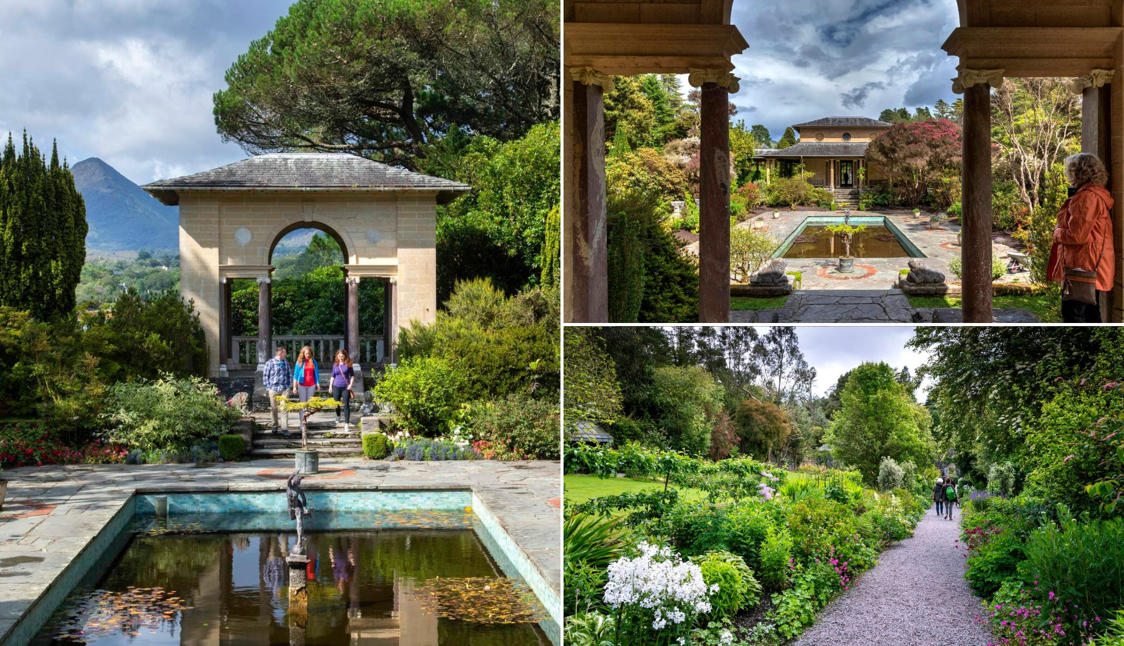
2. Garnish Island

Garnish Island is a lush, 37-acre garden island tucked into Glengarriff Harbour. What began as a vision for a grand mansion evolved into a serene retreat shaped by architect Harold Peto and the art-loving Bryce family in the early 1900s.
To get there, hop on a ferry from Glengarriff village. The 15-minute journey weaves past a seal colony, where around 250 seals lounge and sunbathe on the rocks. Once ashore, you’re free to wander at your own pace.
You’ll want to allow for around 1-1.5 hours on the island. When you’re there, you can admire the exotic plants, climb the 19th-century Martello Tower and enjoy views over beautiful Bantry Bay.
3. Bantry for lunch and the famous house and gardens

When you land back in Glengarrif, hop in the car and take the 20-minute drive to Bantry. If hunger is yet to kick-in, head straight for Bantry House and Gardens.
Bantry House is a grand 18th-century estate overlooking Bantry Bay, filled with original art, antiques, and centuries of history. Outside, its seven formal terraces and sweeping views make it one of the most impressive stops on the Wild Atlantic Way.
When you’re ready for a feed, there are some great options in the town, like:
- The Fish Kitchen (seafood restaurant): Located over a fish shop and known for dishing up ultra-fresh local catch and simple, flavour-packed dishes
- The Snug (traditional pub): Expect hearty Irish lunches like fish and chips in a cosy setting
- Organico Café (health-focused café): Stylish café known for organic, veggie-friendly lunches and top-notch coffee
4. The Glengarriff Waterfall Walk

Head back to Glengarriff and go straight to Glengarriff Nature Reserve where we’ll round-off day 1 of this West Cork itinerary with a handy ramble.
Glengarriff Nature Reserve is a 300-hectare woodland that was once part of the Bantry House estate. It’s now a peaceful haven for walkers and wildlife alike.
The Waterfall Walk is the easiest and most popular trail here. It’s only 15 minutes each way on a gentle forest path that leads to-and-from Glengarriff Waterfall, a scenic cascade that’s especially powerful after rain.
5. Glengarriff for the evening

Photos via The Blue Loo on FB
When you finish up your stroll, head back to your accommodation (Casey’s Hotel and Eccles are both great places to stay) and relax for a bit.
When you’re ready, it’s time to head out for a bite and a sip:
For food
- Eccles Hotel: There are several dining options including the Harbour Bar (casual) and the sea-facing Garnish Restaurant (more formal)
- Casey’s Hotel: You’ll find hearty, traditional Irish fare made with fresh, local ingredients and a strong focus on quality in a casual setting
For drinks
- The Blue Loo: A lively, old-school pub in the town with live music on weekends and a covered beer garden (popular with locals-and-visitors-alike)
- Bernard Harrington’s: A traditional pub with regular live music, finely-poured-pints and a great welcome from owner Bernard
Day 2: The Ring of Beara

Day 2 of this West Cork road trip sees you tackling the Ring of Beara, a 148km/92 mile scenic route that showcases some Cork and Kerry’s most impressive scenery.
The total drive-time for day 2 is around 3.5 hours, give-or-take, but it’ll be broken up a lot with plenty of stops along the way.
1. Healy Pass and Glanmire Lake

The first stop of the day is Healy Pass, around a 27-minute from Glengarriff (you’ll follow the R572 along the coast of the Beara Peninsula before detouring inland).
You’ll enjoy views of the the Sheep’s Head Peninsula and Whiddy Island to your left. Carved through the Caha Mountains during famine relief works in 1847, the pass climbs to 334m via a very twisty road.
Near the summit, there’s a handy pull-in spot (map location here) where you can soak up jaw-dropping views of Glanmire Lake.
2. Castletown-Bearhaven

Photos via Street View
You’ll have to retrace your steps (or tyre tracks, should I say…) back down to the coast road. Castletown-Bearhaven is 25 minutes from Healy Pass and it’s a good spot to stop, grab a coffee and have a little ramble.
Head for Sugrues On The Square and grab a coffee-to-go (they do tasty sweet-and-savoury breakfast, too, if you’re peckish!).
The town, which is one of Ireland’s busiest fishing ports, is cradled between the Caha Mountains and the deep, sheltered waters of Berehaven. Head for a stroll up its colourful streets.
Optional stops: Bere or Dursey Island

The first set of optional stops on this West Cork road trip will see you leave the mainland for some of Cork’s islands.
Just keep in mind that, if you do visit either of the below, you’ll need a good chunk of time:
- Bere Island: A history-packed island easily reached in 15–30 mins by ferry (best explored over a 1/2 or full day)
- Dursey Island A remote, car-free island reached by Ireland’s only cable car (allow 1/2 a day)
3. Allihies

There’s a lot to like about the little village of Allihies (and neighbouring Eyeries). One of the highlights of the area is the road that leads down into Allihies (it’s around a 25-minute drive from Castletown-Bearhaven).
There’s a tiny bit of space to pull in (here on Maps). The view from here, and as you descend, is out of this world. When you arrive in the village, head for Ballydonegan Beach where you’ll see white sand blending into crystal clear water.
Copper mining started in Allihies way back, in 1812. You can learn all about it in the village’s Copper Mine Museum. You can also walk the copper mine trails.
Optional stops around Allihies

There’s plenty to see and do around Allihies for those of you that fancy exploring more of the area. The map above will give you a sense of the lay-of-the-land.
As you can see from the map, there’s plenty to uncover. You could easily spend 5 days on a West Cork road trip that solely focused on Beara and the islands that lay dotted off its coast.
4. Glenbeg Lough

Roughly 40 minutes from Allihies, just beyond Ardgroom, lies Glenbeg Lough – a glacial lake hidden in a bowl of mountains, well off the typical tourist trail.
This quiet spot is part of the Glanmore Bog Special Area of Conservation and home to salmon, brown trout, and even the endangered European eel.
There’s a handy little pull-in spot by the water’s edge, so you can stop, stretch the legs, and take in the stillness. Not bad for a quick detour!
Optional stop: Gleninchaquin Park

Gleninchaquin Park is another optional stop on this West Cork itinerary, and you’ll find it a 45-minute drive from Glenbeg Lough.
Carved by glaciers and framed by the Caha Mountains, Gleninchaquin Park is a privately owned valley near Kenmare known for its roaring waterfalls and scenic trails.
The trails vary in length but, if you only want to have a nosey at the waterfall, you’ll find it a short stroll from the car park (note: you’ll need cash for the car park!).
5. The road from Kenmare to Glengarriff

One of my favourite drives in this corner of Ireland, along with the Slea Head Drive and the Ring of Kerry, is the road between Kenmare and Glengarriff.
Although it only takes 30 minutes to drive, there’s plenty to see-and-do along the way.
The route starts from just outside of Kenmare Town, a 30-minute drive from Gleninchaquin. I’ve outlined it on the map above which takes in everything from the Caha Pass and Molly Gallivan’ to Turner’s Rock and more.
6. Glengarriff for the evening
Photos via The Blue Loo on FB
When you finish up your drive, head back to your accommodation (Casey’s Hotel and Eccles are both great places to stay) and relax for a bit.
When you’re ready, it’s time to head out for a bite and a sip:
For food
- Eccles Hotel: There are several dining options including the Harbour Bar (casual) and the sea-facing Garnish Restaurant (more formal)
- Casey’s Hotel: You’ll find hearty, traditional Irish fare made with fresh, local ingredients and a strong focus on quality in a casual setting
For drinks
- The Blue Loo: A lively, old-school pub in the town with live music on weekends and a covered beer garden (popular with locals-and-visitors-alike)
- Bernard Harrington’s: A traditional pub with regular live music, finely-poured-pints and a great welcome from owner Bernard
Day 3: Sheep’s Head, Mizen and more

Day 3 of this West Cork itinerary has a total of 3 hours and 20 minutes drive time with plenty of stops along the way.
You’ll be following the Sheep’s Head and Mizen road trip that I have outlined on the map above. Day 3 ends in Skibbereen where you’ll be spending 2 nights.
1. Fionn mac Cumhaill’s Seat

Photos via Google Street View
Leave Glengarriff and head west along the coastal road, where sweeping views of sea and sky quickly unfold. Around 45 minutes later, you’ll arrive at your first stop — Fionn mac Cumhaill’s Seat (here on Maps).
This Wild Atlantic Way Discovery Point offers a handy pull-in spot with panoramic views over Kilcrohane, Bantry Bay, and the distant Beara Peninsula.
The stone bench is perched on Seefin, the highest point on the Sheep’s Head Peninsula, and it was unveiled in 1996 to mark the opening of the Sheep’s Head Way walking trail.
It was sculpted by Cork artist Ken Thompson and features a line from Seamus Heaney that captures the power of the landscape. The name comes from Irish mythology, where Fionn mac Cumhaill is said to have rested here, legs stretched toward the lake below.
2. Sheep’s Head Lighthouse

Continue along the road for about 20 minutes and you’ll reach the car park for the Sheep’s Head Lighthouse — a compact white tower built in 1968 to guide tankers bound for the Gulf Oil terminal on Whiddy Island.
Standing at 7 metres tall, its light sits 83 metres above sea level and flashes three times every 15 seconds.
Now fully automated and unstaffed, the lighthouse is powered by ESB poles, with construction materials originally delivered via helicopter in 250 separate runs.
The walk from the car park to the lighthouse takes roughly 30–35 minutes each way — be sure to check the warnings on the map above before setting off!
3. Dunmanus Bay views

Photos licensed via Shutterstock
As you make your way along the eastern side of the Sheep’s Head Peninsula, you’ll enjoy sweeping views over Dunmanus Bay and across to the rugged hills and headlands of the Mizen Peninsula.
This peaceful, winding stretch often clings to the hillside, revealing glimpses of old stone walls, scattered farmsteads, and the endless blue of the Atlantic below.
On a clear day, you can see as far as Mount Gabriel and beyond. There’s no stop along this section — just take it all in as you cruise along!
4. Dooneen Pier

Photo left: Google Maps. Right: Shutterstock
Dooneen Pier is about a 15-minute drive from the Sheep’s Head Lighthouse car park. It stretches quietly into Dunmanus Bay, a subtle but striking reminder of the peninsula’s rich maritime heritage.
Originally built in the 1800s, the pier served as a vital landing point for coal and salt, essential supplies for the local fishing industry.
You’ll still see the remains of the old storehouse nearby, along with a concrete magazine. It’s well worth pausing here to take in the views and the history etched into the stone.
5. Dunlough Fort

The 1-hour drive from Dooneen Pier to Dunlough Castle takes you through the heart of the Mizen Peninsula, where narrow roads wind through open hillsides, bogland, and along weathered stone walls.
Along the way, you’ll pass quiet fields and catch distant glimpses of the Atlantic before arriving at a small car park near the trailhead. There’s an honesty box at the entrance, so bring cash (€3 per person).
Dunlough Fort (aka the Three Castles) was built in 1207 by Donagh O’Mahony. Positioned on a slender strip of land between a mountain lake and dramatic sea cliffs, it was crafted for both defence and seclusion.
The three towers were once linked by a stone wall that stretched from the lake’s edge to the cliffside. The O’Mahonys held it for over four centuries before it was taken by the Crown in the 1600s.
6. Mizen Head

Mizen Head is a 10-minute drive from Dunlough Castle and is home to one of Ireland’s most striking stretches of coastline, anchored by a signal station that has guided vessels since the early 20th century.
Inside the visitor centre, you’ll find stories of shipwrecks like the SS Stephen Whitney, which sank in 1847 and prompted the construction of Fastnet Lighthouse.
There’s also the tale of the 1908 rescue of 63 crew from the SS Trada, along with the introduction of fog signals in 1909. A narrow bridge, first built in 1910, leads you out to cliffs that rise dramatically above the ocean.
7. Barleycove Beach
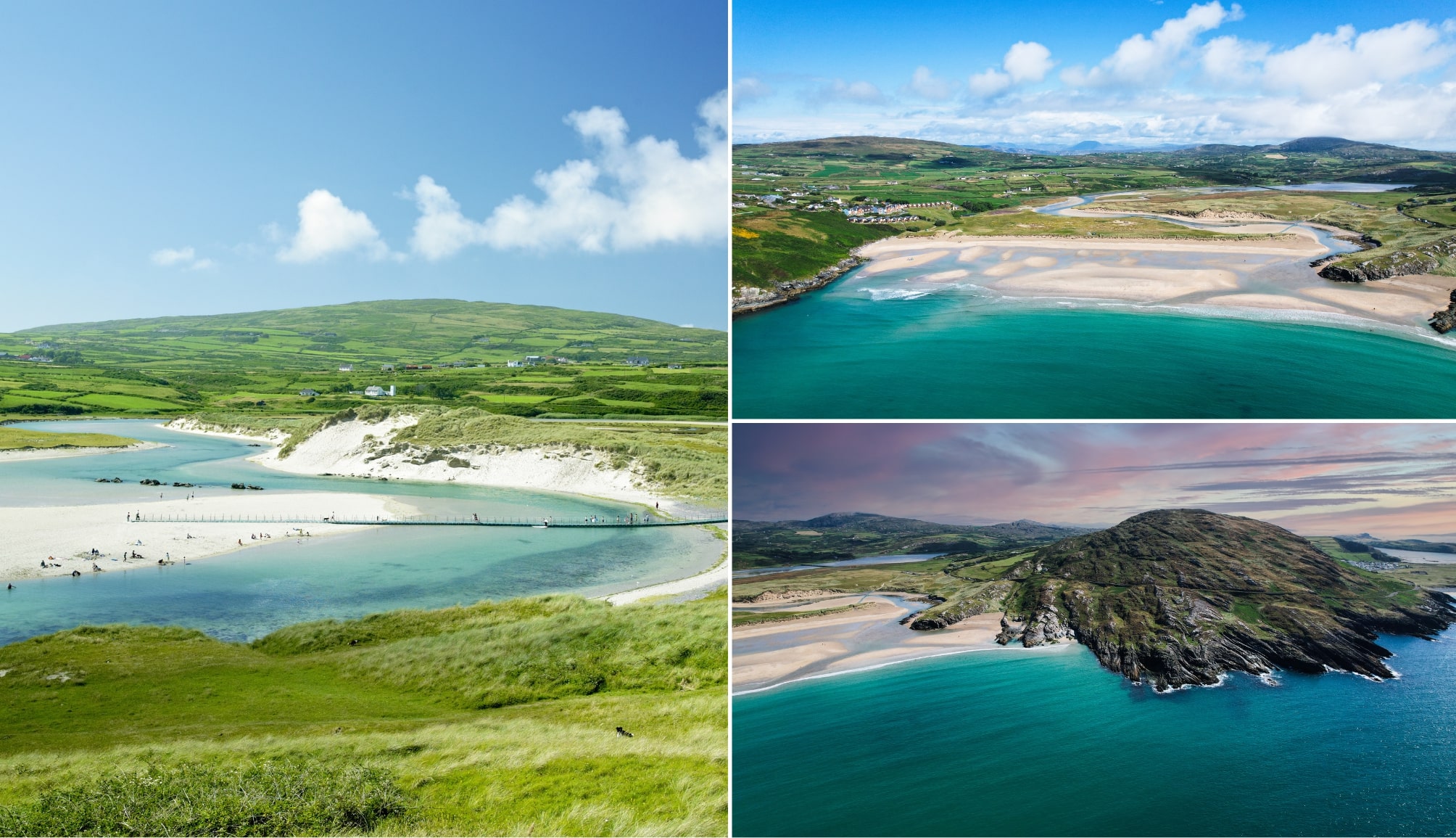
Photos via Shutterstock
Barleycove Beach is a stunning sweep of sand just five minutes from Mizen, nestled between headlands and framed by rolling dunes.
It was created by a tsunami following the 1755 Lisbon Earthquake, when towering waves reshaped this quiet stretch of Cork’s coastline.
Now ranked among West Cork’s best beaches, Barleycove boasts soft golden sand and views stretching all the way to Brow Head.
Set within a Special Area of Conservation, the beach is surrounded by scenic walks, abundant wildlife, and one of the coast’s top seafood lunches at the beach hotel.
8. Brow Head

Brow Head is just 10 minutes from Barleycove and marks the true southernmost point of Ireland’s mainland.
Once a centre for copper mining and British military surveillance, today it’s a windswept headland offering sweeping views over Mizen, Cape Clear, and the vast Atlantic.
The 1804 signal tower still stands sentinel above the cliffs, with old miner’s cottages scattered across the slopes. You can drive to the ‘summit’, though the road is steep and narrow.
9. Altar Wedge Tomb
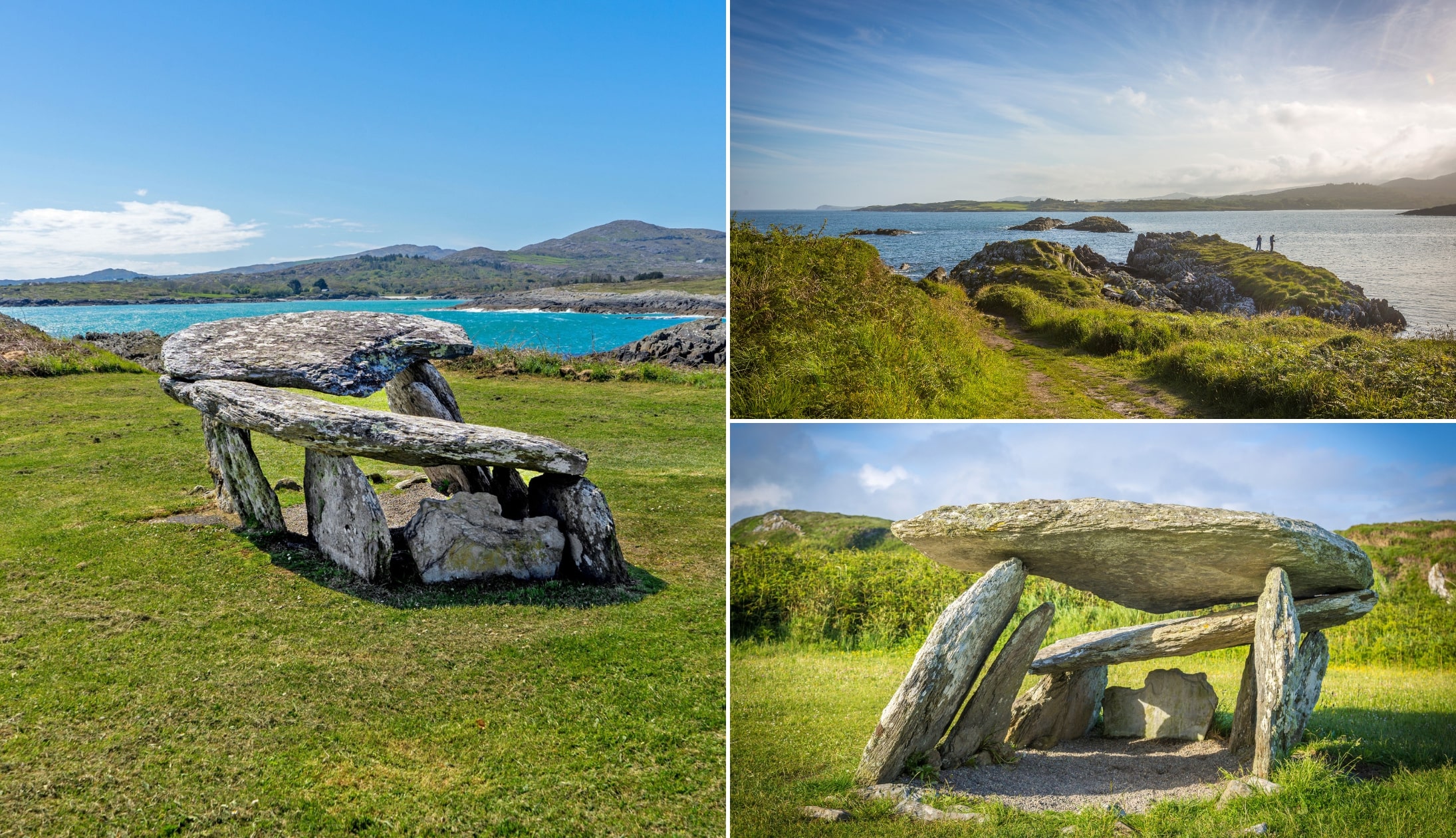
Photos via Shutterstock
One of the final stops on this section of our West Cork road trip is the Altar Wedge Tomb, located about 20 minutes from Brow Head near the edge of Toormore Bay.
This is one of the oldest surviving man-made structures in West Cork. Dating back over 4,000 years, it’s a classic example of a late Stone Age wedge tomb.
Originally used to hold cremated remains, animal bones, and tools, it likely played a role in evolving rituals over many generations. During the Penal Laws, it later served as a hidden Mass site.
Its entrance faces Mizen Peak and may have been aligned with the setting sun during Samhain.
10. Schull
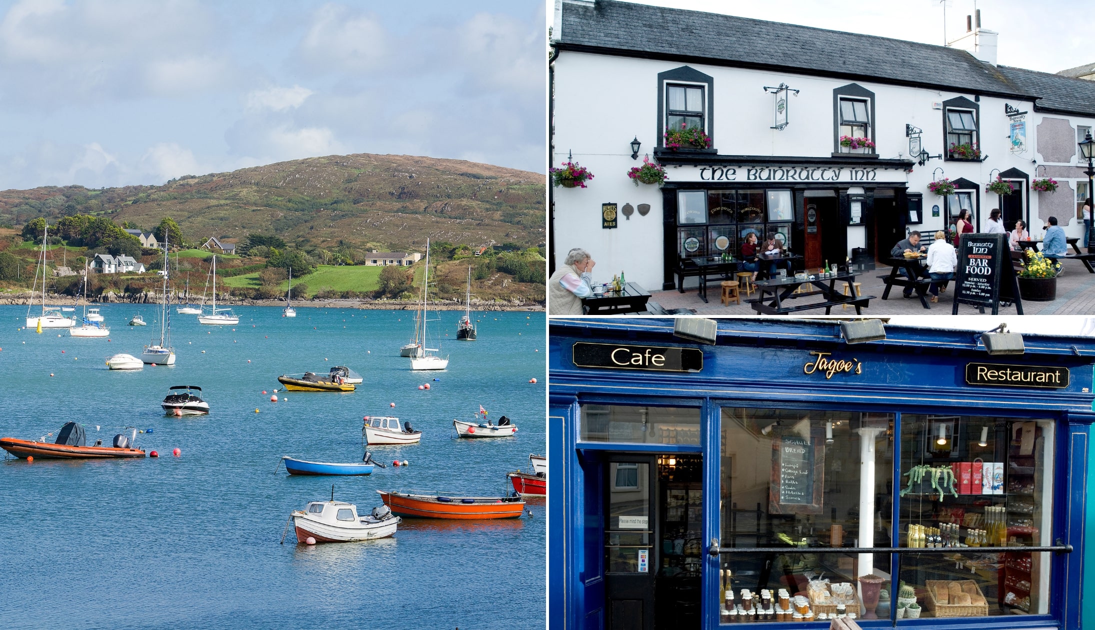
Photo left: Shutterstock. Others: Chrish Hill via Failte Ireland
Continue on to Schull, just a 7-minute drive away. This harbour village sits at the foot of Mount Gabriel on the Mizen Peninsula. Small in size but big on scenery, it’s surrounded by some of the most dramatic landscapes in West Cork.
The harbour is dotted with boats, and the village is well-known for its sailing scene, fresh seafood, and even stargazing, thanks to its planetarium.
You can hike Mount Gabriel for sweeping views, catch a ferry to Cape Clear, or simply take your time exploring the village.
11. Ballydehob
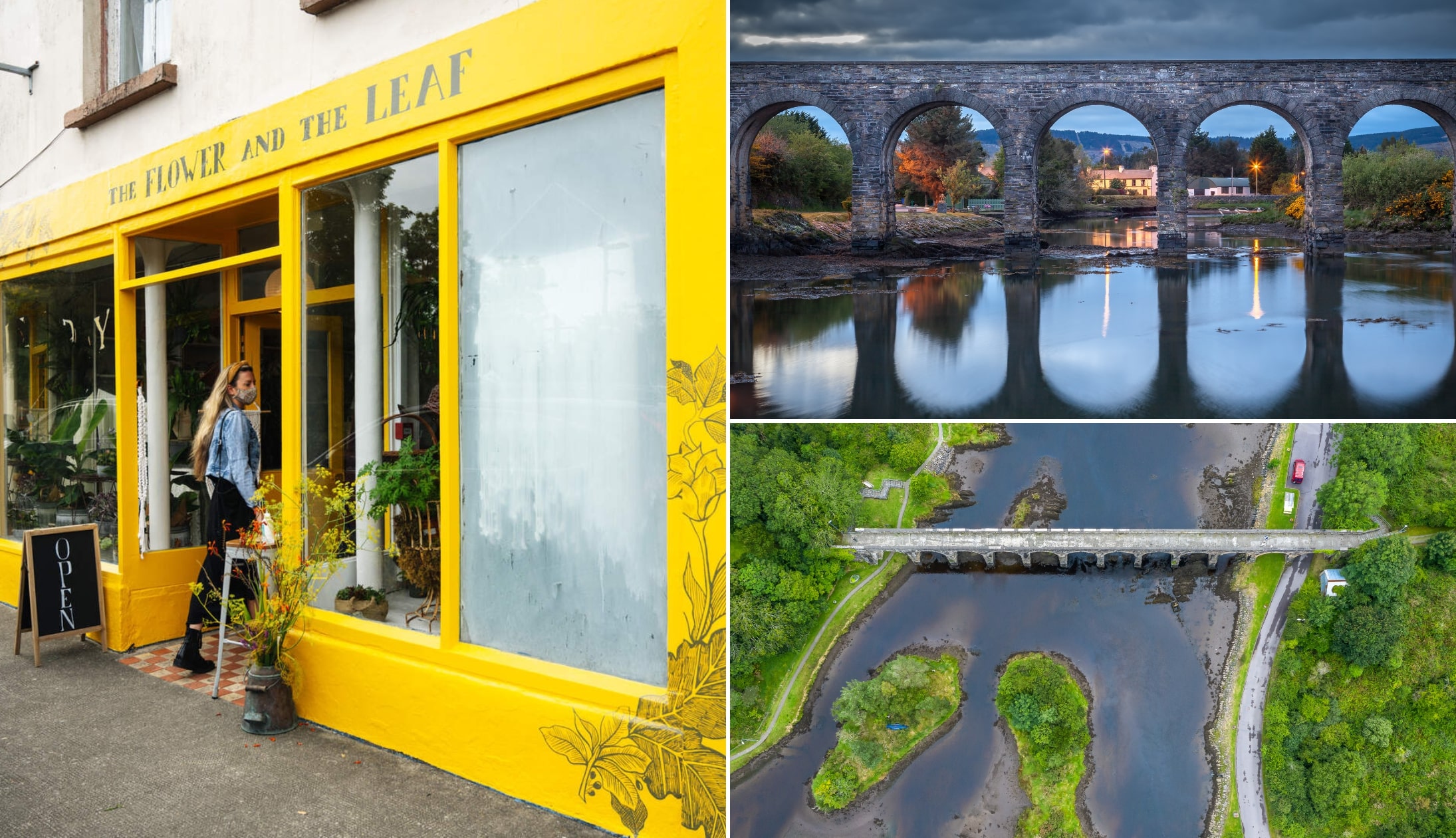
Photo left via Tourism Ireland. Others: Shutterstock
Ballydehob is a quirky little village just 10 minutes from Schull, and it more than holds its own when it comes to charm and character. Its story is shaped by copper mining, famine, and a wave of bohemian artists who arrived in the 1960s.
These days, it’s a vibrant hub with a creative edge, known for its brightly painted buildings, lively arts scene, and a festival calendar that ranges from jazz and folk to vintage threshing weekends.
The old 12-arch railway bridge still stretches across the estuary, acting as a lasting reminder of the days when trains passed through.
12. An evening in Skibbereen

Photos via The Corner Bar on FB
Skibbereen is a 15-minute drive from Ballydehob and it’s here that day 3 of this West Cork itinerary comes to a close.
Here’s some advice on where to grab a bite-to-eat and a post-adventure-pint:
For food
- The Church Restaurant: It’s housed in a restored 19th-century church, this spot offers a striking setting with stained glass windows and soaring wooden ceilings.
- Kennedy Restaurant: Refined dining with local seafood, seasonal game, and a great breakfast menu served daily
- Wild Ways at Dillon’s Corner: Contemporary spot offering inventive mains like pan-fried hake and vegan tagine
For a drink
- The Corner Bar: Cosy pub with a traditional interior, open fire, snug back rooms, and regular live trad music alongside top-quality Guinness
Day 4: Baltimore, Lough Hyne and the West Cork coast
Photos via Shutterstock
Day 4 of this West Cork road trip sees you explore more of the coastline around Skibbereen. Now, if you don’t have the full day today and you’re heading home, just do the first 1/2.
If you have the full day, you’ll drive for a total of 2 hours, but it’ll be broken up with several walks along the way.
1. Baltimore and the beacon
![]()
![]()
The 1st stop of the day is Baltimore, a 20-minute drive from Skibbereen. Baltimore is a historic fishing village in West Cork, once sacked by Barbary pirates in 1631, with a past steeped in piracy, myth, and maritime lore.
Today, it’s a lively coastal hub and ferry port to Cape Clear and Sherkin Islands, famed for diving, sailing, and its dramatic white beacon.
Rising 50ft above the cliffs, the Baltimore Beacon is an iconic coastal marker built in 1849 after the 1798 Rebellion. Walk to it via a short steep climb from the car park or a scenic 1.64km (22 mins) stroll from Baltimore town
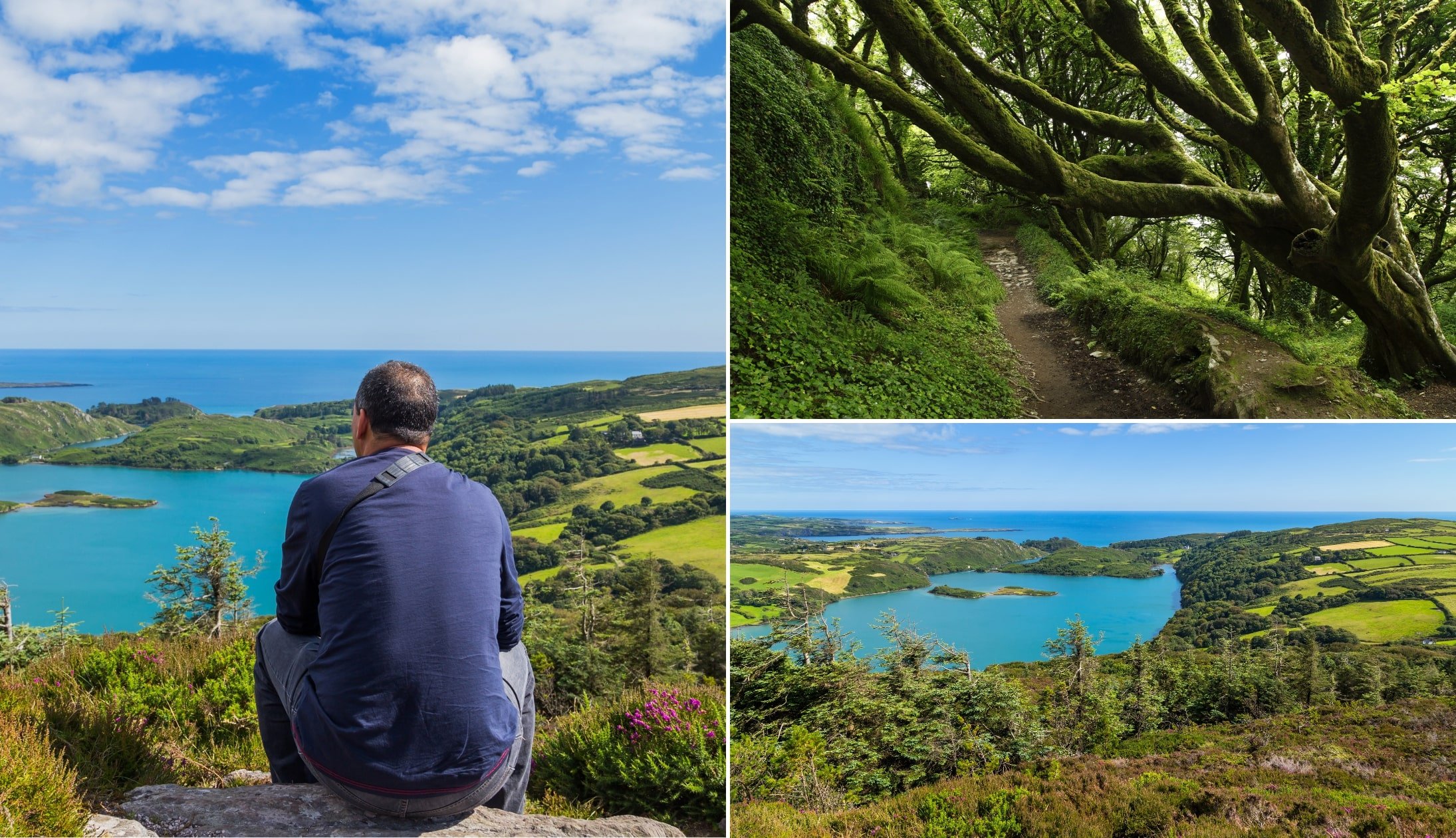
2. Lough Hyne

The next stop is Lough Hyne – a 15-minute drive from Baltimore. I’m going to recommend that you tackle the steep, 3km Knockomagh Hill hike as outlined on my map above.
It takes around one hour and it offers mighty views out over Ireland’s first Marine Nature Reserve. The trail takes you up a quiet forest trail with plenty of good opportunities to soak up the views along the way.
3. Lunch with a view at the The Skibbereen Eagle

Photos via The Skibbereen Eagle on FB
The Skibbereen Eagle in Tragumna is a cosy, old-style Irish pub just 15 minutes from Lough Hyne that’s the ideal spot for a post-hike feed!
Inside, it’s all dark wood, snug corners, and a relaxed, no-frills vibe. On sunny days, grab a seat out front and enjoy glorious sea views.
4. Toe Head

Top right photo via Street View. Others licensed via Shutterstock
The next stop on this West Cork itinerary is one that tends to be missed by many. Although Toe Head is just 10 minutes from The Skibbereen Eagle, it feels like the edge of the world.
The drive in is narrow and winding, but once you reach the base of the old signal tower, the isolation really hits you.
It’s just you, the wind, and views that stretch from Castlehaven to the haunting Stags rocks offshore, like a ruined fortress lost at sea.
5. Knockdrum Stone Fort

Now, please read the warnings above before attempting to walk to Knockdrum Stone Fort (a 10-minute drive from Toe Head).
Knockdrum Stone Fort is a large stone ringfort perched near Castletownshend, with breath-taking views out over the sea.
Dating back to the Iron Age, its walls are 3 metres thick and nearly 30 metres wide. Inside, you’ll find the remains of a rectangular building, a souterrain (an underground passage), and ancient cup marks dotted around the walls.
While this place is impressive, it’s also dangerous to get to, as noted on the map above (if in doubt, avoid!).
6. Union Hall, Glandore and their surrounds

The final chunk of day 4 of this West Cork road trip contains plenty of options for you to consider. Some of the most notable attractions nearby are:
- Union Hall: A small, charming fishing village with a working harbour, scenic walks, and boat tours
- Glandore: A small, picturesque harbour village (enjoy food with a view at the Glandore Inn when the sun’s out)
- Drombeg Stone Circle: Bronze Age stone circle near Glandore with 17 stones, burial site, and sea views
7. This West Cork itinerary wraps up in Skibbereen

Photos via The Church on FB
This West Cork itinerary comes to an end in Skibbereen. As mentioned earlier, here are my go-tos in the town:
For food
- The Church Restaurant: It’s housed in a restored 19th-century church, this spot offers a striking setting with stained glass windows and soaring wooden ceilings.
- Kennedy Restaurant: Refined dining with local seafood, seasonal game, and a great breakfast menu served daily
- Wild Ways at Dillon’s Corner: Contemporary spot offering inventive mains like pan-fried hake and vegan tagine
For a drink
- The Corner Bar: Cosy pub with a traditional interior, open fire, snug back rooms, and regular live trad music alongside top-quality Guinness
Keith O’Hara has lived in Ireland for 35 years and has spent much of the last 13 creating what is now The Irish Road Trip guide. Over the years, the website has published thousands of meticulously researched Ireland travel guides, welcoming 40 million+ visitors along the way. In 2022, the Irish Road Trip team published the world’s largest collection of Irish Road Trip itineraries. Keith lives in Dublin with his dog Toby and finds writing in the 3rd person minus craic altogether.
Samantha
Monday 4th of July 2022
Just what I needed! My partner and I decided to go camping down around west cork the first week in August. We’ve always headed west so having read your article I can’t wait. We have a few more days so think we could do your four day trip at a slower pace. Thanks a mill Keith!
Keith O'Hara
Tuesday 5th of July 2022
Cheers Samantha! Have a great trip!
Garry Nolan
Wednesday 8th of July 2020
Brilliant info there...?
Keith O'Hara
Thursday 9th of July 2020
Cheers Gary! Hope it comes in useful!