
22 Best Walks in Dublin From Easy Strolls to Hikes

Dublin has an almost endless number of walks to choose from, but many of us, myself included, tend to do the same ones over and over again. There’s nothing wrong with that, of course, but there’s a huge variety of trails across the county worth exploring.
In this guide, I’ve rounded up my favourite walks in Dublin, from easy coastal and parkland strolls that won’t work up a sweat to longer hikes in the Dublin Mountains that’ll give the legs a proper workout.
For each walk, I’ve included details on distance, difficulty and duration, along with links to parking areas, public transport information and recommendations for a good coffee or lunch nearby.
The best walks in Dublin
The walks below are ones I’ve returned to time and time again, from popular trails like Howth and Ticknock to quieter spots like Bohernabreena Reservoir.
I’ve included everything from flat, buggy-friendly coastal paths and park walks to tougher mountain hikes with some of the best views in Dublin.
1. The Howth Cliff Walk
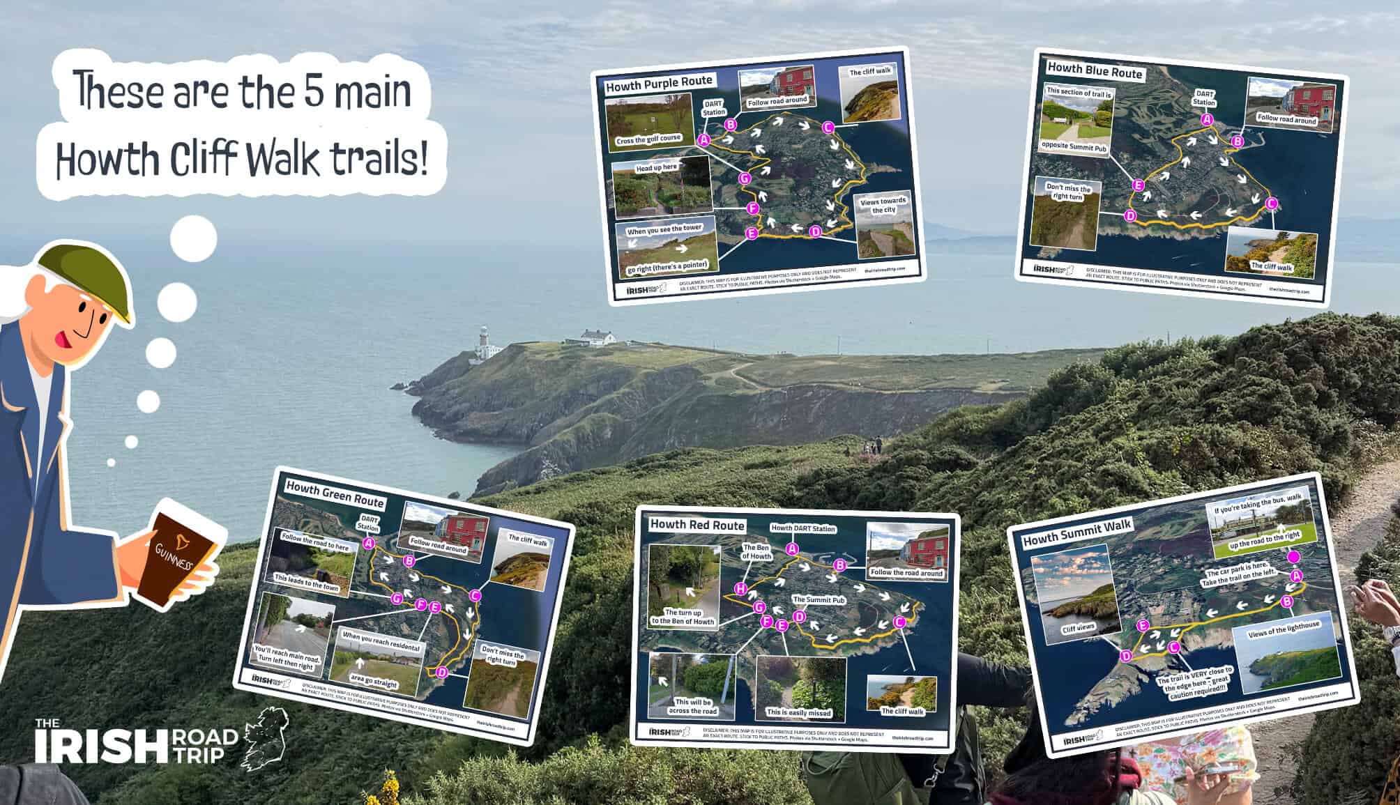
I’ve been doing the Howth Cliff Walk since the early 90s, and it’s still one of my favourite walks in Dublin. The views across Dublin Bay, Ireland’s Eye and the Baily Lighthouse are hard to beat, particularly early in the morning before the crowds arrive.
There are five different routes, but I’d recommend the 6km Green Route to anyone visiting for the first time. It starts in Howth Village, passes Balscadden Bay and follows the cliffs before looping back towards the town. Be prepared for a steep climb from the village, uneven paths and exposed cliff edges.
This isn’t a walk I’d recommend to anyone with limited mobility. If you want the views without committing to a longer hike, I’d recommend the shorter Howth Summit Walk instead. It’s the one I do most often when I’m pressed for time. Afterwards, I’d head to the Abbey Tavern for food or the Harbour Bar for a pint. If you’re after coffee before setting off, Bodega at Howth Market is hard to beat.
Key information
- Distance: 6km (Green Route)
- Duration: Around 2 hours
- Difficulty: Moderate
- Terrain: Uneven paths, steep climbs and exposed cliff edges
- Trail type: Loop
- Toilets: Here near the DART and by the pier here
- Wheelchair accessible: No
- Buggy friendly: No
Directions/getting there
- By DART: Take a northbound DART to Howth Station, around 25-35 minutes from Dublin City.
- By car: Parking is always tricky in Howth. Try this one first and, if it’s full, try this one instead
- Directions: Here’s where you join the cliff path
2. The Poolbeg Lighthouse Walk
The Poolbeg Lighthouse Walk/South Wall Walk is one of my favourite coastal walks in Dublin, but there’s one mistake I’ve made more times than I’d like to admit – not dressing for the wind!
I’ve set off on plenty of mild mornings wearing just a T-shirt, only to regret it 10 minutes later. The Great South Wall is completely exposed, and the wind coming in off Dublin Bay can make it feel much colder than you’d expect.
There are two routes to choose from. The shorter 4km walk starts near Pigeon House Road and takes around an hour, while the longer 11km route starts at Sandymount Strand and takes around 2 hours (see my Google Map above).
Both are relatively flat, with views across Dublin Bay and towards the red lighthouse. Parking can be a nightmare, particularly if you’re tackling the longer route from Sandymount. There are also no public toilets along the walk, so plan accordingly. If you fancy a coffee beforehand, Cat You Cafe is a good option. Afterwards, we usually head to The Merry Cobbler for food.
Key information
- Distance: 4km (short route) or 11km (long route)
- Duration: 40-60 minutes or 1.5-2 hours
- Difficulty: Easy
- Trail type: Out and back
- Terrain: Mostly flat but rough, uneven stone surfaces with gaps between flagstones
- Toilets: None along the walk
- Wheelchair accessible: No – the uneven stones and gaps make access difficult
- Buggy friendly: No – I’ve seen all-terrain buggies struggle here
Directions/getting there
- By car (short route): Park at this small car park on Pigeon House Road or try Shelly Banks car park, which has more spaces. The smaller car park fills quickly.
- By car (long route): So, ideally you’d park in this car park, but Sandymount Strand fills up fast. I find it’s often easier to get parking on Gilford Road
- By public transport: Take a bus to stop 7934 on Sandymount Strand/get the DART to Sandymount.
3. The Killiney Hill Walk

I’ve done the Killiney Hill Walk more times than I can count, and it’s one of those walks that never gets old. It’s short, there’s a decent climb to get the legs moving, and the views from the top are some of the best you’ll get in Dublin.
There are three routes to choose from, but I’d recommend the 2.5km loop that starts at Killiney Hill car park. I always do it clockwise, as you’ll walk towards the views of the Wicklow Mountains from around the halfway point.
The walk takes around 50 minutes, with a few inclines along the way. On a clear day, you’ll have Killiney Beach and the Wicklow Mountains on one side, with views stretching across Dublin City on the other.
Parking can be a pain, especially at weekends, so I’d recommend getting here early. We usually head into Dalkey afterwards for lunch at The Queens Bar. If the weather’s decent, the seats outside make for great people watching!
Key information
-
Distance: 2.5km
-
Duration: Around 50 minutes
-
Difficulty: Easy to moderate
-
Trail type: Loop
-
Terrain: Woodland paths, inclines and some steps
-
Toilets: Public toilets near the Vico Road entrance here
-
Wheelchair accessible: No – steps and inclines on this route
-
Buggy friendly: Not recommended
Directions/getting there
-
By car: Park at the main Killiney Hill car park. It gets particularly busy at weekends. There’s also limited parking near the Killiney Hill Tea Rooms where you can grab a pre-stroll coffee
-
By public transport: Take the DART to Dalkey Station and walk towards the Vico Road. You can enter the park via the Cat’s Ladder or the entrance opposite the public toilets.
4. The Phoenix Park coffee and lunch stroll
This is one of the best Dublin walks if you’re after an easy-going ramble, a couple of coffees and a decent feed at the end. The 6.2km route around the Phoenix Park finishes at the Hole in the Wall pub, which is lavishly decorated from early November. We’ve made this walk and lunch a bit of a Christmas tradition as the decorations really are something else.
I’d start by parking near the Hole in the Wall and grabbing a coffee from Dash before heading into the park. You’ll see Ashtown Castle off to your right before making your way towards the Phoenix Monument and then across to the Papal Cross. Keep an eye out for the deer along the way!
From there, you’ll head towards Magazine Fort and then on to the Wellington Monument. If you’re ready for another coffee, the Phoenix Park Tea Rooms are a handy stop before you make your way back to the Hole in the Wall for lunch.
The walk itself takes around 1.5 hours, but I’d allow 2 hours to enjoy it properly. The paths are well maintained and it’s a relatively easy walk, although you’ll need to leave the main paths to reach some of the attractions.
Key information
-
Distance: 6.2km
-
Duration: 1.5 hours walking, but allow 2 hours
-
Difficulty: Easy
-
Trail type: Loop
-
Terrain: Mostly flat, well-maintained park paths with some grassy sections
-
Toilets: At the Visitor Centre, Phoenix Park Tea Rooms and Knockmaroon entrance. New eco-toilets were also recently installed at the Papal Cross car park and GAA grounds
-
Wheelchair accessible: The main paths are suitable, but the full route and some attractions involve crossing grass
-
Buggy friendly: Yes, if you stick to the main paths
Directions/getting there
-
By car: Park in the car park by the Dash container here
-
By public transport: The number 39, 70, 99, C5 and C6 bus routes go to the park. You could also take the Red Line Luas to Heuston and walk to the park from there
5. The Ticknock Fairy Castle Loop

The Ticknock Walk is one of my favourite walks in the Dublin Mountains, but there’s one thing worth knowing before you set off – the main car park can be an absolute disaster at weekends. Personally, I wouldn’t head here after 9am on a weekend morning.
There are two trails here, but I’d recommend the 5.8km Fairy Castle Loop, which takes around 1.5 to 2.5 hours. It starts at the main Ticknock car park, and you’ll follow the green arrows through the forest towards Three Rock Mountain.
The views from Three Rock across Dublin City are worth the climb alone, but the trail continues towards Two Rock Mountain, where you’ll find Fairy Castle, a Neolithic passage tomb. From there, the route loops back towards the car park.
There are some decent inclines, but anyone with a reasonable level of fitness should manage it. I tend to avoid the upper section of the car park as it can get wedged, and getting back out can be a pain.
There’s also a handy coffee stop at the Biking.ie café near the car park, where you can grab a coffee and something to eat before or after the walk. If you’ve a designated driver and fancy a pint afterwards, the Blue Light is a short spin away.
Key information
-
Distance: 5.8km
-
Duration: 1.5 to 2.5 hours
-
Difficulty: Moderate
-
Trail type: Loop
-
Terrain: Forest tracks, tarmac paths and uphill sections
-
Toilets: Facilities at the Biking.ie café near the car park
-
Wheelchair accessible: No – the full loop includes inclines and uneven sections
-
Buggy friendly: No
Directions/getting there
-
By car: Start at the main Ticknock car park. There’s an alternative car park at Kilmashogue Forest, although this involves a much longer walk.
-
By public transport: Take the Luas Green Line to Dundrum and catch the 44B towards Glencullen (weekdays only). The best thing to do is to get a taxi. It’s not ideal, and it’ll cost you around €30 from town.
6. The Malahide to Portmarnock coastal walk
If you’re looking for nice walks in Dublin that are flat, easy to follow and suitable for kids, the Malahide to Portmarnock Coastal Walk is well worth considering.
As you can see from my map above, you can start from either end, but I much prefer starting in Malahide. There’s more parking available and, if you’re arriving by DART, the walk through Malahide village to the coast is much nicer than the approach from Portmarnock Station.
We usually park at Malahide Beach car park or along the coast road and grab a coffee from The Greenery, just across the road. From there, it’s a lovely 3.2km stroll along the coast towards Portmarnock, with sea views the whole way.
Once you reach Portmarnock, you can head down onto the beach if the weather’s decent. We tend to stop for lunch at Gourmet Food Parlour along the coast on the way back to the car.
It’s one of the better coastal walks in Dublin for families with buggies, and the path is also wheelchair friendly. Allow around 45 minutes to an hour each way at a leisurely pace, or longer if you’re stopping for coffee, lunch and a wander along the beach.
Key information
-
Distance: 3.2km each way (6.4km return)
-
Duration: 45 minutes to 1 hour each way
-
Difficulty: Easy
-
Trail type: Out and back
-
Terrain: Flat, paved coastal path
-
Toilets: Recently renovated public toilets beside Malahide Beach car park here. There are also public toilets near Portmarnock Beach here, although I’ve found these to be fairly grim
-
Wheelchair accessible: Yes, along the paved coastal path
-
Buggy friendly: Yes
Directions/getting there
-
By car: I’d recommend starting at Malahide Beach car park, although there’s also parking along the coast road. You can start from Portmarnock Beach if that suits you better.
-
By public transport: Take the DART to Malahide and walk through the village towards the coast. Alternatively, take the DART to Portmarnock, although it’s a less scenic walk to the coastal path.
7. Bohernabreena Reservoir

The Bohernabreena Reservoir Walk is one of the more overlooked walks in Dublin, and it’s a great option if you fancy escaping the city for an hour or two.
There are two trails here, but I’d recommend the shorter 4km Lower Reservoir Loop. I’ve done both, and I find the first section of the longer 8.5km route a bit of a slog, as you’re walking along a narrow country road before you reach the reservoir.
The shorter walk starts at the paid car park, where you can grab a coffee from Goughie’s before setting off. Make sure you use the second trail entrance and follow the route clockwise. You’ll walk alongside the reservoir, surrounded by woodland and the hills of the Glenasmole Valley.
On the second half of the loop, you’ll pass the remains of St Ann’s Churchyard, which was in use until the mid-16th century. The walk takes around 1 to 1.5 hours, and if you arrive early, there’s a good chance you’ll have much of the place to yourself.
Key information
-
Distance: 4km
-
Duration: 1 to 1.5 hours
-
Difficulty: Easy
-
Trail type: Loop
-
Terrain: Mostly level reservoir paths and woodland tracks
-
Toilets: At the paid car park
-
Wheelchair accessible: Some sections are accessible, but the full 4km loop isn’t
-
Buggy friendly: Suitable for all-terrain buggies, although some sections can be uneven and muddy
Directions/getting there
-
By car: I’d recommend using the paid car park near the Lower Reservoir, which costs €5 and has toilets. There’s also a small free car park with around 15 spaces, but parking here can be difficult. Don’t park along the narrow road.
-
By public transport: This is one of the few forest walks in Dublin with no public transport service
8. The family friendly St Anne’s Park walk
If you’re looking for easy walks in Dublin that are suitable for kids, St Anne’s Park between Clontarf and Raheny is a great option. It’s also one of those places where you can easily spend a couple of hours without realising it.
I’d recommend parking along All Saints Road and entering the park from there. You’ll pass the dog park on one side and the remote-controlled car track on your right, which is always worth stopping at for a look when there’s something going on.
Keep following the paths and you’ll come towards the Clock Tower, with the park’s Long Avenue off to your right. If you’re visiting at the weekend, you can have a wander around the farmers’ market before heading up to the Red Stables for a coffee.
If you’ve the kids with you, there’s a playground beside the Red Stables, too. The paths throughout the park are generally wide, flat and well maintained, so it’s a handy spot for a relaxed stroll with a buggy.
Key information
-
Distance: Flexible, depending on the route you take
-
Duration: 1 to 1.5 hours, or longer with stops
-
Difficulty: Easy
-
Trail type: Flexible park walk
-
Terrain: Mostly flat, well-maintained paths
-
Toilets: At the Red Stables
-
Wheelchair accessible: Yes
-
Buggy friendly: Yes
Directions/getting there
-
By car: Multiple car parks like this one at the Stables, this one near North Bull Island and there’s parking along the roads at the perimeter of the park
-
By public transport: Take the DART to Raheny Station and walk to the park, or use one of the bus services along the Howth Road.
9. The Hellfire Club Walk

The Hellfire Club Walk is one of the best walks in Dublin when it comes to scenery, combining panoramic views across the city with the ruins of a supposedly haunted hunting lodge.
I’ve done this walk around six times, and I’d recommend following the 4.2km Montpelier Loop, which takes around 1 to 1.5 hours. There’s a fair aul incline near the beginning, but it’s manageable for anyone with a moderate level of fitness.
From the car park, follow the blue waymarkers around Montpelier Hill. You’ll eventually get views across the Glenasmole Valley before reaching the ruins of the Hellfire Club. You can have a nosey around the old building, but mind your step if you head inside.
The views across Dublin City from the top are worth the climb alone. Just be careful on the way back down, as the final descent is steep and very uneven, particularly after rain.
There’s sometimes a coffee van at the car park during the warmer months. Alternatively, Timbertrove Café is a short drive away and has coffee, sandwiches and plenty of treats. We usually take the short spin to The Merry Ploughboy for lunch afterwards.
Key information
-
Distance: 4.2km
-
Duration: 1 to 1.5 hours
-
Difficulty: Moderate
-
Trail type: Loop
-
Terrain: Forest tracks, gravel paths, steep inclines and an uneven descent
-
Toilets: No public toilets at the trailhead
-
Wheelchair accessible: No
-
Buggy friendly: No
Directions/getting there
-
By car: Park at the Hellfire Club car park. It can be mobbed at weekends, so arrive early.
-
By public transport: I wouldn’t recommend walking to the trailhead from the nearest bus stop, as there’s no footpath along the approach road and cars travel quickly. You can take the 15 bus towards Ballycullen Road and arrange a taxi for the final stretch.
10. The Herbert Park/Sandymount Strand loop
This is a great weekend walk if you’re after a mix of parkland, coastal views, good coffee and a nosey at some of Dublin’s most extravagant houses.
I’d argue it’s best done by public transport, but I often manage to get parking along Elgin Road in Ballsbridge. From there, start with a loop of Herbert Park before heading to Mister Magpie on Merrion Road for a coffee.
You’ll then make your way through the residential streets towards Sandymount Strand. One of my favourite parts of this walk is having a nosey at the enormous houses along the way. There are some serious gaffs around this part of Dublin!
When you reach the strand, you’ll see the Poolbeg chimneys off to your left. Turn right and follow the promenade, enjoying the views across Dublin Bay before cutting back inland around Sydney Parade Avenue and making your way towards Ballsbridge.
Key information
-
Distance: Depends on the exact loop
-
Duration: Allow around 1.5 to 2 hours
-
Difficulty: Easy
-
Trail type: Loop
-
Terrain: Mostly flat park paths, pavements and coastal promenade
-
Toilets: Public toilets in Herbert Park
-
Wheelchair accessible: Yes
-
Buggy friendly: Yes
Directions/getting there
-
By car: I often find parking along Elgin Road
-
By public transport: Take the DART to Syndey Parade or Landsdown and join the loop from there
11. The Tibradden Wood Walk

The Tibradden Wood Walk is a good option if you’re after a reasonably challenging ramble in the Dublin Mountains, with a mix of woodland trails, open mountain and some mighty views.
The walk starts at Tibradden car park and follows a gravel trail through the forest. It’s fairly gentle at first, but once you leave the trees behind, the path gets steeper and rockier as you make your way towards the summit.
At the top, you’ll find a prehistoric burial cairn believed to date back to the Bronze Age. On a clear day, you’ll also get views across Dublin Bay towards Howth. I’d allow around 2 hours for the walk, particularly if you’re planning to spend a bit of time at the summit. If you fancy a coffee before setting off, The Hazel House is nearby and worth nipping into.
Key information
-
Distance: Approximately 2.5km each way
-
Duration: Around 2 hours
-
Difficulty: Moderate
-
Trail type: Out and back
-
Terrain: Gravel forest tracks, rocky mountain paths and uphill sections
-
Toilets: No
-
Wheelchair accessible: No
-
Buggy friendly: No
Directions/getting there
-
By car: Park at Tibradden Wood car park on the R116. There are around 50 spaces, but it can fill quickly at weekends.
-
By public transport: There’s no direct public transport service to the trailhead, so driving is the more practical option.
12. The Carrickgollogan Forest Walk

The Carrickgollogan Forest Walk is one of the shorter Dublin walks in this guide, but what it lacks in distance, it makes up for in scenery.
There are two trails to choose from. I’d recommend the Mountain Access Route, which takes around 30 minutes and brings you up to the Viewing Rock. There’s a steep climb involved, but you’ll be rewarded with views across south Dublin, north Wicklow and the Irish Sea.
Alternatively, the easier 2km Lead Mines Way takes around 40 minutes and brings you to the old Ballycorus Lead Mines chimney, which has an unusual spiral staircase winding around its exterior.
Parking is limited to around 10 spaces, so I’d get here early at weekends. Whenever we visit, we tend to head into Enniskerry afterwards for a ramble and lunch. It’s a gorgeous little village for a stroll, and the Enniskerry Inn does hearty pub grub.
Key information
-
Distance: 2km for the Lead Mines Way; 0.5km for the Mountain Access Route
-
Duration: Around 40 minutes for the Lead Mines Way; 30 minutes for the Mountain Access Route
-
Difficulty: Easy for the Lead Mines Way; moderate for the Mountain Access Route
-
Trail type: Loop (Lead Mines Way) and out and back (Mountain Access Route)
-
Terrain: Forest tracks, woodland paths and a steeper, uneven climb to the Viewing Rock
-
Toilets: No
-
Wheelchair accessible: No
-
Buggy friendly: No
Directions/getting there
-
By car: Park at Carrickgollogan Forest car park. Parking is free, but there are only around 10 spaces.
-
By public transport: There’s no direct public transport service to the trailhead, so driving is the more practical option.
13. The Cruagh Woods Walk

The Cruagh Woods Walk is one of the more overlooked walks in the Dublin Mountains, and it’s a great option if you fancy a forest ramble with some glorious views thrown in.
I’d recommend the 4km Slí na Sláinte Loop, which starts at Cruagh Woods car park and takes around an hour. There’s a fair bit of climbing involved, with roughly 100m of ascent, but the forest tracks are well maintained and it’s manageable for anyone with a reasonable level of fitness.
From the car park, follow the forest road clockwise through the larch and spruce trees. As you climb, you’ll start getting views towards Tibradden Mountain and Fairy Castle. Around the halfway point, the trees open up and, on a clear day, you’ll get views across Dublin City towards Dollymount Strand and Howth.
I’d try to do this one on a clear morning, as the views are a big part of the appeal. If you fancy a coffee or something to eat afterwards, Timbertrove Café is a short drive away and a handy spot to finish up.
Key information
-
Distance: 4km
-
Duration: Around 1 hour
-
Difficulty: Moderate
-
Trail type: Loop
-
Terrain: Well-maintained forest roads with gradual inclines
-
Toilets: No public toilets at the trailhead
-
Wheelchair accessible: No
-
Buggy friendly: No
Directions/getting there
-
By car: Park at Cruagh Woods car park, just off Cruagh Road. There are around 40 spaces, but I’d recommend arriving early at weekends.
-
By public transport: There’s no direct public transport service to the trailhead, so driving is the more practical option.
14. North Bull Island
The North Bull Island and Dollymount Strand walk is one of the longer coastal walks in Dublin, and I’d strongly recommend wrapping up well, as it can get ridiculously windy here.
If you’re driving, cross the wooden bridge onto the Bull Wall and grab a parking space wherever you can. From there, get yourself a coffee from Happy Out before continuing along the wall towards Dollymount Strand. You’ll have some lovely views across Dublin Bay as you go.
When you reach the beach, turn left and follow the sand with Howth ahead of you. Keep going until you reach the exit near the Interpretative Centre, then follow the path back towards the main road. Turn left here, with St Anne’s Park across the road, and continue back towards the Bull Wall.
If you’re hungry afterwards, Bay Restaurant in Clontarf is a great spot for lunch, although it’s rarely not busy. There’s also Pog Cafe just before you turn onto the Bull Wall.
Key information
-
Distance: 6.7km
-
Duration: 2 hours
-
Difficulty: Easy
-
Trail type: Loop
-
Terrain: Paved Bull Wall, sandy beach and roadside paths
-
Toilets: Paid public toilets near Happy Out on the Bull Wall
-
Wheelchair accessible: The Bull Wall section is accessible, but the full beach loop isn’t suitable
-
Buggy friendly: The Bull Wall section is suitable, but the sandy beach can be difficult with a buggy
Directions/getting there
-
By car: Cross the wooden bridge onto the Bull Wall and park in a designated space along the wall. Parking can be difficult on sunny weekends.
-
By public transport: You can get the 130 bus from Talbot St. It’ll drop you nearby.
Other good walks in Dublin worth considering
If none of the Dublin walks above take your fancy, there are plenty of other options dotted around the county. Here are eight more worth considering, from easy walks in parks in Dublin to coastal trails with views across the Irish Sea.
- Marlay Park Loop: A 3.7km trail that takes around an hour and is an easy, family-friendly walk along mostly paved paths. You’ll find a walled garden, playgrounds, a café and public toilets, along with two car parks.
- Donabate to Portrane Cliff Walk: This 4km return walk starts near the Shoreline Hotel in Donabate and follows the cliffs towards the Martello Tower at Tower Bay. Allow around an hour.
- Skerries Loop: The Skerries Loop is a short, easy 1.8km walk that takes around 20 to 30 minutes. The route is almost entirely paved, making it a handy option for a gentle stroll before grabbing food in Skerries town.
- Bushy Park Loop: The 3.1km Bushy Park Loop in Terenure takes around 40 minutes to an hour. It’s an easy walk past woodland, ponds and the River Dodder, with a playground and a popular Saturday market.
- Ardgillan Castle: The 4.1km loop around Ardgillan Castle near Balbriggan takes approximately 1 to 1.5 hours. This easy walk passes through parkland, woodland and open meadows, with views across the Irish Sea towards the Mourne Mountains.
- Fernhill Park Walk: Fernhill Park in Stepaside has a network of paths through woodland and landscaped gardens, with views towards the Dublin Mountains. Allow 30 to 60 minutes for an easy stroll with some hilly sections.
- Loughshinny Coastal Walk: Loughshinny has three separate 3.5km walking routes, each taking roughly an hour. Depending on your choice, you’ll pass historic copper mines, coastal scenery, a Martello Tower or the Drumanagh promontory fort.
- Malahide Castle and Park Loop: The 4km Malahide Castle Loop takes around 45 minutes to an hour along mostly well-maintained paths. It’s an easy, family-friendly walk through the castle grounds, with a café, toilets and free parking.
Walks near Dublin

Now that we have the best walks in Dublin out of the way, it’s time to see what walks near Dublin are worth tackling. County Wicklow is the obvious place to start. Within roughly an hour’s drive of Dublin, you’ll find everything from short forest walks to demanding mountain hikes.
There are dozens of walks in Wicklow to choose from, but these seven are particularly worth considering:
-
Ballinastoe Woods: A 6km forest walk that takes around 1.5 hours. Relatively easy, with woodland trails and views towards Lough Tay.
-
Djouce Mountain: A 6km hike that takes around 2 to 2.5 hours. Moderate difficulty, with a sustained climb and boardwalk sections leading towards the summit.
-
Lough Ouler: A 4.5km mountain hike taking approximately 2.5 hours. Challenging terrain and navigation make this better suited to experienced walkers, with views of Wicklow’s heart-shaped lake.
-
The Great Sugarloaf: A short but steep hike taking around 1 hour. Moderate difficulty, with a rocky scramble near the summit and panoramic views across Wicklow and Dublin.
-
Djouce Woods: Two forest loops to choose from. The easier Blue Loop is 4.5km and takes 1.5 hours, while the longer Deerpark Loop is 9km and takes around 3 hours.
-
The Spinc: A demanding 9.5km loop taking approximately 3.5 to 4 hours. The initial climb is steep, but the elevated boardwalk offers views over Glendalough’s Upper Lake.
-
Bray to Greystones Cliff Walk: The original 7km coastal route takes around 2 to 2.5 hours, but sections remain closed due to landslides. Don’t attempt the full cliff path while the closures are in place.
FAQs
Below, I’ve answered some of the questions about walking in Dublin that land in my inbox most often. If there’s something I haven’t covered, feel free to ask in the comments. For more ways to explore the capital, see my guide to things to do in Dublin.
Where can I go for a good walk and coffee in Dublin?
My favourite combination is the Phoenix Park loop, which starts with coffee from Dash, passes several of the park’s main landmarks and finishes at the Hole in the Wall for lunch. For something coastal, I’d recommend the Malahide to Portmarnock walk. Grab a coffee from The Greenery in Malahide before following the coastal path towards Portmarnock.
What are the best walks in Dublin if I don’t want the hassle of parking?
I’d head to Howth. You can take the DART directly into the village and join the cliff walk from there, avoiding the parking headache altogether. The Malahide to Portmarnock Coastal Walk is another good option, as you can take the DART to Malahide and walk through the village to the coast. St Anne’s Park is also accessible from Raheny Station.
What are the best buggy-friendly walks in Dublin?
St Anne’s Park, Malahide to Portmarnock and the main paths through Phoenix Park are good choices if you’re walking with a buggy.
What are some nice walks in Dublin for views without a long hike?
I’d recommend Killiney Hill. The 2.5km loop takes around 50 minutes and offers views across Dublin Bay and towards the Wicklow Mountains. The shorter Howth Summit Walk is another option if you want coastal scenery without committing to the full 6km cliff loop. Neither is completely flat, but both are manageable for many walkers.
Where can I go for a walk in Dublin followed by a good pub lunch?
Killiney Hill is a favourite of mine for this. The 2.5km loop takes around 50 minutes, and afterwards you can head into Dalkey for lunch at The Queens Bar. The Phoenix Park loop is another good option, particularly in the run-up to Christmas when the Hole in the Wall is decorated.

Keith O’Hara has lived in Ireland for 37 years and has spent much of the last 13 creating what is now The Irish Road Trip guide. Over the years, the website has published thousands of meticulously researched Ireland travel guides, welcoming 40 million+ visitors along the way. Recently, the Irish Road Trip team published the world’s largest collection of Irish Road Trip itineraries. Keith lives in Dublin with his dog Toby and finds writing in the 3rd person minus craic altogether.
Donabate to Portrane Loop Walk
Fabulous information and so detailed. Thank you so much
What are the best dog friendly walks that you would recommend
Hey Niamh – I’m actually in the middle of trying to figure that out for myself, as I’ve over-walked every trail near where I live with my own dog. One I’ve tried a few times recently is St Anne’s. There’s a great dog enclosure there too (one for big dogs and another for small to medium).
Hiya. Donadea Forest walk in Co.Kildare is stunning. There is a beautiful lake, ruins of a Castle, a Graveyard, and a quirky Chalet type Coffee Shop. The Autumn colours are wonderful.
Wwwww! Absolutely very helpful information, made many walks around Dublin, your information made me realize ahhh you still have to go bro… 😎
– cheers!