
24 Best Drives In Ireland (I’ve Driven Them All)

Ireland is home to some spectacular scenic drives, from short mountain passes that take less than an hour to coastal routes that deserve several days.
I’ve spent over two decades exploring Ireland by car, and some of my favourite places are along the routes below, from the narrow roads of the Skellig Ring in Kerry to the mountain scenery of Donegal’s Inishowen Peninsula.
In this guide, I’ll take you through some of the most scenic drives in Ireland, with maps, driving times and recommendations on where to stop along the way.
The best drives in Ireland

Some of the best road trips in Ireland are the ones you stumble upon by chance while exploring somewhere else. Looking back, I first discovered Ballaghbeama Gap in Kerry completely by accident, while the Boyne Valley Scenic Drive was one I gradually got to know on journeys to and from where my girlfriend is from.
The drives below are a mix of those unexpected discoveries and routes I’ve deliberately gone out of my way to explore over the years.
1. The Skellig Ring (Kerry)

I first drove the Skellig Ring on a bitterly cold weekend in January 2016, and I was blown away by it (literally, at times…). I’ve returned many times since, and it’s still one of my favourite scenic drives in Ireland.
What makes it special is that you leave the busy Ring of Kerry behind and head out onto a much quieter, wilder stretch of the Iveragh Peninsula, with narrow coastal roads, mountain passes and views of the Skellig Islands.
The Skellig Ring is approximately 50km long when you include Valentia Island. It takes around 1.5 hours to drive without stopping, but I’d allow at least 3 hours to explore it properly.
You can start from Waterville or Cahersiveen, although I’d recommend the Waterville side, following the coast through Ballinskelligs and Portmagee before continuing onto Valentia.
The Skellig Ring at a glance
- Distance: 50km including Valentia Island
- Driving time: Around 1.5 hours without stops
- Time needed: At least 3 hours
- Start/finish: Waterville / Cahersiveen
- Best stops: St. Finian’s Bay, Coomanaspig Pass, Kerry Cliffs and Valentia Island
- Route map: Follow my Skellig Ring route
2. The Ring of Beara Drive (Cork)

There’s something bleak but beautiful about the Beara Peninsula in winter. The scenery is wild and windswept, the roads are quiet and, at times, you feel like you have the whole place to yourself.
I’ve explored Beara in different seasons over the years, and the contrast with summer is remarkable as the colourful villages, particularly Castletownbere and the lovely little town of Glengarriff, come alive.
The Ring of Beara is a 148km scenic route that takes you around the peninsula, between Bantry Bay and Kenmare Bay. It’s much quieter than the neighbouring Ring of Kerry, and I’d argue that some of the scenery is every bit as impressive.
I’d recommend driving it clockwise, starting from either Glengarriff or Kenmare – both make great bases for what is one of the best road trips in Ireland.
The Ring of Beara at a glance
- Distance: 148km
- Driving time: 3-4 hours without stops
- Time needed: At least half a day, ideally a full day
- Start/finish: Glengarriff or Kenmare
- Best stops: Allihies, Castletownbere and the Healy Pass
- Route map: Follow my Ring of Beara route
3. The Inishowen 100 (Donegal)

One of the biggest mistakes you can make when visiting Donegal is trying to squeeze too much into a short visit. It’s a huge county, and the Inishowen Peninsula alone deserves two full days.
I’ve stayed in Buncrana, which remains one of the friendliest places I’ve ever spent a night, and in a thatched cottage just beyond Mamore Gap. Both trips left me itching to return.
My most recent spin around Inishowen was in summer 2026 and, despite it being peak tourist season, the roads were surprisingly quiet compared to the likes of Connemara.
There’s something wonderfully unspoiled about this corner of Ireland. No shiny visitor centres at every turn or attractions dressed up for tourists. Just mountains, beaches, winding roads and scenery that is simply superb.
The Inishowen 100 at a glance
- Distance: 160km
- Time needed: At least 5 hours, ideally a full day
- Start/finish: Flexible, but I recommend starting at Grianán of Aileach and heading clockwise towards Buncrana
- Best stops: Fort Dunree, Mamore Gap, Five Finger Strand, Malin Head and Kinnagoe Bay
- Route map: Follow my Inishowen 100 guide
4. The Gleniff Horseshoe Drive (Sligo)
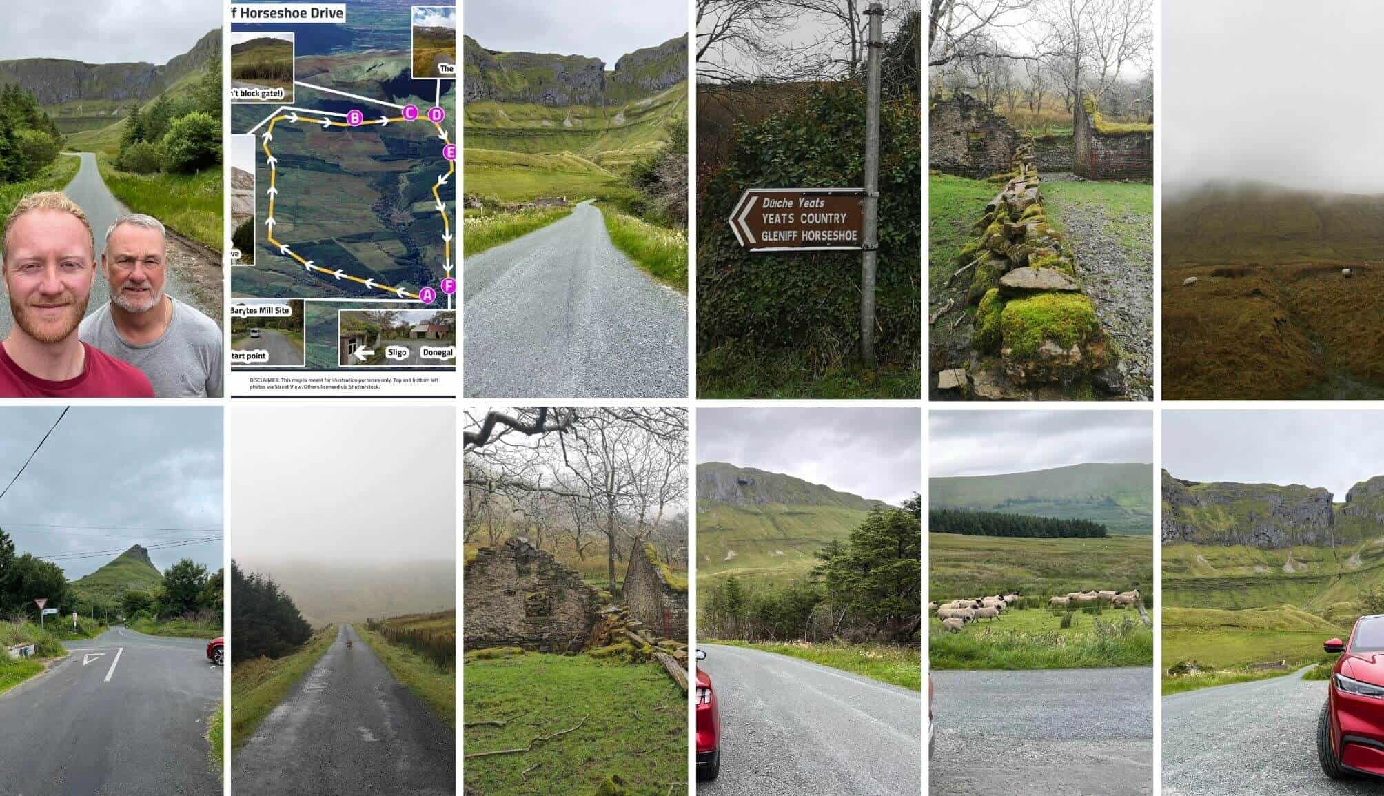
At just under 8.5km, the Gleniff Horseshoe is arguably one of the best short scenic drives in Ireland, taking you through a glacial valley surrounded by the mighty Dartry Mountains.
As you’ll see from my photos above, I’ve driven this route in everything from blazing sunshine during a heatwave to thick fog with barely any visibility. And, surprisingly, I think it’s even more impressive when the mist rolls in.
There’s something almost otherworldly about the mountains looming out of the clouds. Another reason I love this drive is how quiet it can be. Visit outside the busy summer months and there’s a good chance you’ll have much of the route to yourself.
One warning: you’ll see Diarmuid and Gráinne’s Cave high up in the mountainside. It might look tempting, but please don’t attempt to climb up to it. The ascent/descent is extremely dangerous.
The Gleniff Horseshoe at a glance
- Distance: Just under 8.5km
- Driving time: Around 25-30 minutes without stops
- Time needed: Allow at least 1 hour
- Start/finish: Gleniff Barytes Mill Site, driving clockwise
- Best for: Dramatic mountain scenery and a short, quiet drive
- Route map: Follow my Gleniff Horseshoe route on Google Maps
5. The Ring of Kerry (Kerry)

I’ve driven the Ring of Kerry 15 times over the last 20 years and, if there’s one piece of advice I’d give anyone planning to tackle it, it’s to allow more time than you think you’ll need.
The 179km route takes around 3.5 hours to drive without stopping, but doing it that way means missing much of what makes this corner of Kerry so special.
From the lakes and mountains of Killarney National Park to the beaches around Derrynane and the coastal views at Coomakista, there’s an enormous amount to see along the way.
I’d drive clockwise from Killarney and, if time allows, add the Skellig Ring. It’s a detour I’ve made on countless occasions and it’s arguably one of the most scenic drives in Ireland.
The Ring of Kerry at a glance
- Distance: 179km (111 miles)
- Driving time: Around 3.5 hours without stops
- Time needed: 7-8 hours, or 9-10 with the Skellig Ring
- Start/finish: Killarney, driving clockwise
- Best stops: Torc Waterfall, Ladies View, Kenmare, Derrynane Beach and Coomakista
- Route map: Follow my Ring of Kerry itinerary
6. The Copper Coast (Waterford)

Back in 2023, during one of Ireland’s rare September heatwaves, I took the notion to head down to Waterford on a Thursday, a couple of days before a wedding I was attending that Saturday.
I spent the time driving the Copper Coast, kicking myself for regularly ignoring this corner of the island. While plenty of visitors to Waterford stick to the city, they’re missing a coastline that’s home to some of the finest beaches in Ireland.
And, unlike some of the better-known road trips in Ireland, you don’t have to cover huge distances to see the best of it.
The Copper Coast is a 25km stretch of coastline between Tramore and Dungarvan, named after the copper mines that once operated here. It’s now a UNESCO Global Geopark, with rugged cliffs, secluded coves and beaches dotted along the route.
The Copper Coast at a glance
- Distance: Approximately 25km along the coastline
- Driving time: Around 1 hour without stops
- Time needed: At least 3-4 hours
- Start/finish: Tramore to Dungarvan, or vice versa
- Best stops: Kilmurrin Beach, Dunabrattin Head, Bunmahon Beach, Ballydowane Beach and Clonea Strand
- Route map: Follow my Copper Coast itinerary
7. The Causeway Coastal Route (Antrim)

Of all the scenic drives in Northern Ireland, the Causeway Coastal Route is arguably the best known, largely thanks to the Giant’s Causeway.
But this is far from a one-horse show. In fact, having driven the route both as a day trip and over a weekend, I’d argue that some of its best bits are the places many visitors drive straight past.
The 185km route runs from Belfast to Derry, passing through the nine Glens of Antrim and along a coastline dotted with castles, beaches, little villages and some wonderfully dramatic stretches of road.
If I was planning this drive for the first time, I’d split it over two days and use Ballycastle as a base. It’s well placed for tackling the Glens of Antrim on day one before spending day two around the Giant’s Causeway, Carrick-a-Rede and Dunluce Castle.
The Causeway Coastal Route at a glance
- Distance: 185km (115 miles)
- Time needed: Ideally 2 days, although you can see the main highlights in 1
- Start/finish: Belfast to Derry, or vice versa
- Where to stay: Ballycastle makes a convenient base for a 2-day trip
- Best stops: Glenariff Forest Park, Torr Head, Carrick-a-Rede, Giant’s Causeway and Dunluce Castle
- Route map: Follow my Causeway Coastal Route directions
8. The Slea Head Drive (Dingle Peninsula)

I’ve been heading down to the Dingle Peninsula with friends since I was old enough to drive, and it’s one of those places I never tire of returning to.
The peninsula is home to some of Ireland’s most impressive coastal scenery, while Dingle Town itself boasts some of the finest traditional pubs in the country. It’s a combination that’s hard to beat.
The Slea Head Drive is a roughly 47km circular route that starts and finishes in Dingle Town, taking you past ancient sites, sandy beaches and spectacular views of the Blasket Islands.
Now, although I’ve never found the drive particularly difficult, I’ve spoken to plenty of visitors who found some of the narrower sections stressful. Take your time, stick to the clockwise route and be prepared to pull in to let oncoming traffic pass.
The Slea Head Drive at a glance
- Distance: Approximately 47km
- Driving time: Around 1-1.5 hours without stops
- Time needed: At least half a day
- Start/finish: Dingle Town, driving clockwise
- Best stops: Dunbeg Fort, Slea Head viewpoint, Coumeenoole Beach, Dunmore Head and Clogher Head
- Route map: Follow my Slea Head Drive directions
9. The Sally Gap Drive (Wicklow)

The Sally Gap is a popular escape for us Dubliners, and for good reason. In around an hour, you can leave the city behind and find yourself surrounded by mountains, lakes and vast stretches of open bogland.
I’ve driven this route countless times over the years, and there’s a particular stretch of road approaching the Sally Gap where you can feel like you’re the last person left on earth.
I usually start in Roundwood, grab a coffee and then head towards Lough Tay, better known as Guinness Lake. From there, the road climbs towards the Sally Gap crossroads before descending past Glenmacnass Waterfall towards Laragh.
One warning, though. If you’re visiting on a sunny Saturday, I’d strongly recommend getting on the road before 10am. This is one of the best drives near Dublin, and the roads and viewpoints can get very busy when the weather plays ball.
The Sally Gap Drive at a glance
- Distance: Approximately 27km from Roundwood to Laragh via Sally Gap
- Driving time: Around 45 minutes without stops
- Time needed: Allow 1.5-2 hours
- Start/finish: Roundwood to Laragh
- Best stops: Lough Tay viewpoint, Sally Gap crossroads and Glenmacnass Waterfall
- Route map: Follow my Sally Gap Drive directions
10. The Doolough Valley (Galway and Mayo)

Of all the road trips in Ireland, the road through the Doolough Valley is my aul lad’s favourite. And, having travelled it with him over the years, I can understand why.
There are no major tourist attractions or busy towns along the way, just a quiet road winding between enormous mountains, dark lakes and some of the most unspoiled countryside in the west of Ireland.
Start in Leenaun, where you’ll be treated to views over Killary Harbour before passing Aasleagh Falls and heading into the Doolough Valley itself.
The stretch alongside Doo Lough is the highlight for me. With the mountains rising steeply on either side and the inky-black lake stretching out beside the road, there’s something both eerie and mesmerising about the place.
The Doolough Valley Drive at a glance
- Distance: Approximately 30km
- Driving time: Around 40 minutes without stops
- Time needed: Allow 1-1.5 hours
- Start/finish: Leenaun (Galway) to Louisburgh (Mayo), or vice versa
- Best stops: Killary Harbour, Aasleagh Falls, Doo Lough and the Doolough Valley Famine Memorial
- Route map: Follow my Leenaun to Louisburgh drive directions
11. Yeats County Loop (Sligo)

One of the things I love most about Sligo is how close so many of its best attractions are to one another. You can spend a weekend here, see an enormous amount and rarely spend more than 30 minutes in the car between stops.
The Yeats County and Lough Gill Scenic Loop is a great example of this. Starting and finishing in Sligo Town, it takes you through a mix of mountain scenery, lakeside roads and some of the county’s best coastal spots.
Along the way, you’ll pass through Rosses Point and Drumcliffe, enjoy views of the unmistakable Benbulben Mountain and follow the shores of Lough Gill.
Finish in Strandhill. It’s a lovely spot for a walk along the seafront, and there are plenty of places to grab a coffee or something to eat before heading back to Sligo Town.
The beauty of this route is that you can cover plenty of ground without spending the whole day driving. Just don’t underestimate how much time you’ll want to spend out of the car.
The Yeats County Loop at a glance
- Time needed: Allow at least 4 hours, ideally longer if you plan on walking
- Start/finish: Sligo Town (circular route)
- Best stops: Rosses Point, Drumcliffe, Benbulben, Lough Gill and Strandhill
- Best for: Seeing a variety of Sligo’s scenery without long stretches of driving
- Route map: Follow my Yeats County Loop on Google Maps
12. The Atlantic Drive (Mayo)

I’ve visited Achill Island in the height of summer, during the colourful days of autumn and in the depths of winter, and I’m convinced there’s no bad time to explore it.
There’s nowhere quite like it. The mountains, enormous sea cliffs and beautiful beaches give the island a wild, almost remote feel, despite the fact that you can drive straight onto it from the mainland.
The Atlantic Drive is one of my favourite ways to explore the island, particularly the 4.5km stretch between Cloughmore and Ashleam. Here, the road twists along the coast before reaching a viewpoint overlooking Ashleam Bay.
My mapped route continues past Keel Beach before finishing at Keem Bay, where a winding road descends towards a sheltered beach surrounded by steep green hills. It’s a spectacular finish to what I consider one of the best coastal drives in Ireland.
The Atlantic Drive at a glance
- Driving time: Just over 1 hour without stops
- Time needed: Allow at least 2-3 hours
- Start/finish: Achill Sound to Keem Bay
- Best stops: Cloughmore, Ashleam Bay viewpoint, Keel Beach and Keem Bay
- Best time to visit: Beautiful year-round, with a different atmosphere in each season
- Route map: Follow my Achill Island Atlantic Drive directions
13. The Torr Head Scenic Route (Antrim)

The Torr Head Scenic Route is responsible for what was probably the most nerve-racking drive I’ve ever experienced. I first tackled it back in 2009, without paying much attention to the weather forecast.
We’d barely started when thick mist rolled in, making it almost impossible to see the road ahead. Now, this isn’t a road you want to be driving in poor visibility. It’s extremely narrow in places, with steep climbs, sharp bends and very little room for error.
Thankfully, I returned many years later, this time having planned around the weather, and the experience couldn’t have been more different. On a clear day, the coastal views are magnificent, and you can even see Scotland across the water.
The route runs between Cushendun and Ballycastle, taking in Torr Head and the spectacular Murlough Bay. It’s an alternative to the main Causeway Coastal Route, but I’d only recommend it to confident drivers in good conditions.
The Torr Head Scenic Route at a glance
- Driving time: Around 40 minutes without stops
- Time needed: Allow 1.5-2 hours to explore
- Start/finish: Cushendun to Ballycastle, or vice versa
- Best stops: Torr Head viewpoint and Murlough Bay
- Driving difficulty: Narrow roads, steep hills and sharp bends. Not suitable for nervous drivers or large vehicles
- Important warning: Avoid this route in fog or poor visibility
- Route map: Follow my Torr Head Scenic Route directions
14. The Loop Head Drive (Clare)

The Loop Head Peninsula is often overlooked by visitors to Clare, with most heading straight for the Cliffs of Moher or the Burren. I’d recommend starting this drive in Kilkee before following the coast towards Loop Head Lighthouse, around 40 minutes away.
For me, the highlight is the Cliffs of Campoy. The coastal views here are spectacular, but a word of warning: the ground can be extremely muddy, and the mossy grass can disguise how close you are to the cliff edge. Keep well back.
Finish at Loop Head Lighthouse, where a short walk rewards you with views of the enormous sea stack just offshore.
The Loop Head Drive at a glance
- Driving time: Around 40 minutes without stops
- Time needed: Allow 2-3 hours
- Start/finish: Kilkee to Loop Head Lighthouse
- Best stops: Kilkee Cliffs, Cliffs of Campoy and Loop Head Lighthouse
- Route map: Follow my Loop Head Drive directions
15. The Hook Peninsula Coastal Drive (Wexford)

The Hook Peninsula is a solid choice if you want to combine a coastal drive with some of Wexford’s most interesting historic sites, including Tintern Abbey and Hook Head Lighthouse.
I’d recommend starting at Tintern Abbey before heading towards Duncannon Fort, Dollar Bay and Loftus Hall. Continue to Hook Head Lighthouse, one of the oldest operational lighthouses in the world, before looping back via Baginbun Beach and Saltmills.
One piece of advice: save this drive for a dry day. I tackled it recently in miserable weather, and the only respite we got was when we ran from the car into the café at Hook Head Lighthouse!
Much of the appeal here is getting out and exploring, so rain can really take away from the experience.
The Hook Peninsula Drive at a glance
- Driving time: Just over 1 hour without stops
- Time needed: Allow 3-4 hours
- Start/finish: Tintern Abbey to Hook Head Lighthouse
- Best stops: Tintern Abbey, Duncannon Fort, Dollar Bay, Loftus Hall and Hook Head Lighthouse
- Route map: Follow my Hook Peninsula route on Google Maps
16. The Burren Scenic Loop (Clare)

There are few places in Ireland quite like the Burren. Its vast stretches of limestone pavement can feel almost lunar, particularly when you’re driving through the quieter parts of the Burren National Park.
My preferred route is the Burren Scenic Drive – a 155km loop starting and finishing in Ballyvaughan. It takes in some of Clare’s best-known attractions, along with stretches of countryside that many visitors never get to see.
The first two stops I’d make are Aillwee Cave and Poulnabrone Dolmen before heading through the Burren National Park towards Kilfenora, with a detour past Father Ted’s House.
From there, the route continues through Lahinch to the Cliffs of Moher and Doolin before returning to Ballyvaughan along the coast.
The Burren Scenic Loop at a glance
- Distance: 155km
- Time needed: A full day
- Start/finish: Ballyvaughan (circular route)
- Best stops: Poulnabrone Dolmen, Burren National Park, Father Ted’s House, Cliffs of Moher and Doolin
- Route map: Follow my Burren Scenic Loop directions
17. The Boyne Valley Scenic Drive

I’ll admit that the Boyne Valley is a slightly unusual choice for a guide to scenic drives in Ireland. You won’t find the dramatic coastal roads or mountain passes of Kerry and Donegal here.
What you will find is over 9,000 years of history, with an extraordinary number of ancient sites, castles and monuments packed into a relatively small area.
The route takes in Brú na Bóinne, the Hill of Tara, Trim Castle, Loughcrew Cairns, Kells, Mellifont Abbey and Monasterboice. My advice is to pick 3 or 4 stops rather than trying to see everything in one day. You’ll get far more out of the experience.
The Boyne Valley Scenic Drive at a glance
- Time needed: A full day, or 2 days to explore more thoroughly
- Area covered: Counties Meath and Louth
- Best stops: Brú na Bóinne, Hill of Tara, Trim Castle, Loughcrew Cairns and Monasterboice
- Best for: History, ancient monuments and castles rather than dramatic scenery
- Route map: Follow the Boyne Valley Drive route
18. Ballaghbeama Pass (Kerry)

I first stumbled upon Ballaghbeama Pass completely by accident, and it’s since become one of my favourite places to visit in Kerry.
Tucked away in the middle of the Iveragh Peninsula, between Blackwater and Glencar, this narrow mountain road feels a world away from the busy Ring of Kerry.
The highlight is the stretch where the road winds between enormous, rugged mountains. I’ve driven it several times since that first visit, and I’m always struck by how quiet it is.
There are two things worth knowing before you go. The road is very narrow, with limited places to pull in, so nervous drivers may find it challenging.
Also, check the route on Google Maps before setting off and download it for offline use. Mobile signal is practically non-existent in parts of the pass.
Ballaghbeama Pass at a glance
- Driving time: Around 40 minutes without stops
- Time needed: Allow 1-1.5 hours
- Start/finish: Blackwater to Glencar
- Best for: Remote mountain scenery and escaping the Ring of Kerry crowds
- Driving difficulty: Very narrow roads with limited passing places
- Route map: Follow my Ballaghbeama Pass directions
19. The Sky Road (Galway)

The Sky Road is one of the shortest scenic drives in Ireland, but the views from its highest point are among the finest in Connemara.
This 16km loop starts and finishes in Clifden, taking you around the Kingston Peninsula with sweeping views over Clifden Bay and its offshore islands.
The Upper Sky Road is the one you want, tackled clockwise, rather than the Lower Road. Around 5.5km from Clifden, you’ll reach a large parking area with the best views along the route.
I’ve driven this road several times, and although it’s straightforward to follow, there are narrow sections and blind bends that require care. If you have extra time, stop at Clifden Castle or make the short detour to Eyrephort Beach.
The Sky Road at a glance
- Distance: 16km
- Driving time: Around 30 minutes without stops
- Time needed: Allow 45-60 minutes
- Start/finish: Clifden Town (clockwise loop)
- Best stops: Upper Sky Road viewpoint, Clifden Castle and Eyrephort Beach
- Important tip: Take the Upper Road for the best views
- Route map: Follow my Sky Road directions
20. The Sheep’s Head Drive (Cork)

The Sheep’s Head Peninsula is one of the quieter corners of West Cork, and a great alternative to the busier Ring of Beara.
This 70km loop takes you along both sides of the peninsula, with narrow coastal roads, views across Bantry Bay and plenty of little places worth stopping at.
I’d recommend starting in Durrus and heading towards Ahakista before continuing out towards the tip of the peninsula. From there, the route loops back towards Bantry.
My advice is to combine the drive with a walk. Sheep’s Head has some excellent coastal trails, and you’ll miss much of what makes the peninsula special if you never leave the car.
The Sheep’s Head Drive at a glance
- Distance: Approximately 70km
- Time needed: Allow at least 3-4 hours, longer if walking
- Start/finish: Durrus to Bantry via the Sheep’s Head Peninsula
- Best stops: Ahakista, coastal viewpoints and the walking trails near Sheep’s Head
- Best for: Quiet coastal roads and combining a scenic drive with a walk
- Route map: Follow my Sheep’s Head Peninsula route on Google Maps
21. The Connemara Loop

The 93km Connemara Loop is a great way to see several very different sides of Connemara in a single day, from the mountains around Leenaun to the beaches of Renvyle and the Inagh Valley.
I’d recommend starting at Maam Cross and heading towards Leenaun, where the mountains seem to close in around the road.
From there, the route follows Killary Harbour before winding towards the Renvyle Peninsula, where Glassilaun and Lettergesh are well worth stopping at.
After Kylemore Abbey, you’ll drive through the Inagh Valley, one of my favourite stretches of road in Connemara, before returning to Maam Cross.
The Connemara Loop at a glance
- Distance: Approximately 93km
- Driving time: Around 1 hour 45 minutes without stops
- Time needed: Allow 4-6 hours
- Start/finish: Maam Cross (circular route)
- Best stops: Killary Harbour, Glassilaun Beach, Kylemore Abbey, Inagh Valley and Derryclare Lough
- Route map: Follow my Connemara Loop directions
22. Priest’s Leap Drive (Cork and Kerry)

If you’re looking to explore off the beaten path Ireland, the Priest’s Leap Drive is well worth considering. This narrow mountain pass links Coomhola Bridge in Cork with Bonane in Kerry, and it’s one of the more challenging roads I’ve driven in Ireland.
Much of the route is barely wide enough for one car, but the reward is panoramic views stretching towards Bantry Bay and the Caha Mountains.
The last couple of times I’ve tackled it, I’ve started in Bantry and allowed plenty of time to pull in and admire the scenery.
A warning for nervous drivers: The road is extremely narrow, with steep sections and limited passing places. I’d avoid it altogether in poor weather if you’re not confident behind the wheel.
Priest’s Leap at a glance
- Driving time: Just over 1 hour from Bantry
- Time needed: Allow around 2 hours with stops
- Start/finish: Bantry to Bonane, via Coomhola Bridge
- Best for: Remote mountain scenery and panoramic views
- Driving difficulty: Challenging, with long single-lane stretches
- Route map: Follow my Priest’s Leap Drive route
23. Glengesh Pass (Donegal)

The Glengesh Pass is one of my favourite short drives in Donegal, and it’s one I’ve returned to plenty of times over the years.
The road winds through a steep-sided valley between Ardara and Glencolumbkille, with a series of sharp bends and mountain views that make the journey feel much longer than it actually is.
I’d recommend starting in Ardara. Grab a coffee in the town before heading towards the pass, where you’ll find a handy viewing area overlooking the winding road and valley below.
It’s a straightforward drive, but take your time on the bends and keep an eye out for oncoming traffic.
Glengesh Pass at a glance
- Driving time: Around 40 minutes without stops
- Time needed: Allow 1-1.5 hours
- Start/finish: Ardara to Glencolumbkille
- Best stop: Glengesh Pass viewpoint
- Best direction: From Ardara towards Glencolumbkille
- Route map: Follow my Glengesh Pass directions
24. The Cooley Peninsula Scenic Drive (Louth)

On a clear day, the views across Carlingford Lough towards the Mourne Mountains make the Cooley Peninsula one of the most rewarding coastal drives in Ireland’s northeast.
This 80km route starts in Dundalk, follows the coast through the medieval town of Carlingford and finishes across the border in Newry.
Carlingford is the highlight for me. It’s a lovely little medieval town, with narrow streets, old buildings and plenty of places to stop for lunch.
I’d recommend taking your time along the stretch beside the lough. When the weather is clear, the views of the Mournes rising across the water are particularly impressive.
The Cooley Peninsula Drive at a glance
- Distance: Approximately 80km
- Time needed: Allow 2-3 hours with stops
- Start/finish: Dundalk to Newry
- Best stops: Carlingford Town, Carlingford Lough and viewpoints towards the Mourne Mountains
- Best for: Coastal scenery, mountain views and a stop in a historic town
- Route map: Follow my Cooley Peninsula route on Google Maps
FAQs about scenic drives in Ireland
Here are answers to some of the questions I get about choosing a scenic drive in Ireland, particularly if you’re short on time or aren’t comfortable driving on narrow roads.
What is the most scenic drive in Ireland?
If I had to choose just one, I’d go with the Skellig Ring in Kerry. It’s a relatively short drive, but the combination of coastal roads, mountain scenery and views of the Skellig Islands is hard to beat. The Ring of Beara and Slea Head Drive would be close behind.
What are the best short scenic drives in Ireland?
The Gleniff Horseshoe in Sligo (8.5km) and the Sky Road in Connemara (16km) are two of my favourites. Both can be driven in under an hour, although I’d allow extra time for viewpoints and photographs.
What is the best scenic drive near Dublin?
The Sally Gap Drive in Wicklow is my pick. It’s around an hour from Dublin City, and the route from Roundwood to Laragh takes in Lough Tay, the Sally Gap crossroads and Glenmacnass Waterfall.
Keith O’Hara has lived in Ireland for 35 years and has spent much of the last 13 creating what is now The Irish Road Trip guide. Over the years, the website has published thousands of meticulously researched Ireland travel guides, welcoming 40 million+ visitors along the way. In 2022, the Irish Road Trip team published the world’s largest collection of Irish Road Trip itineraries. Keith lives in Dublin with his dog Toby and finds writing in the 3rd person minus craic altogether.



Very interesting list, not sure which one of those I haven’t done yet to start on! One you might’ve wanted to include is the Conor Pass in Dingle, stunning!
Well I’ve done The Sky Road, the Inishowen Peninsula, The Rathmullan to Fanad, the Leanaun to Louis burgh, the Loop Head, and I live on the Sally Gap so not a bad start. Feeling a slight prejudice against the South West which I’ll have to get handle on.
Yes! It’s lovely. Also slieve league … And walking from Doolin to the cliffs of Mohr a must!
Brilliant. We have done 18 of these drives. Some of them several times, like the Doo Lough drive. One year we rented a thatched cottage for a week, halfway up the Glengesh Pass !
The Carlingford loop. Newry – Warrenpoint – Rostrevor – Greecastle – FERRY – Greenore – Carlingford – Omeath – Black Mountain – Newry.
Absolutely excellent selection. Have driven most of them at one time or another, but you have more information than I would ever know. All of them excellent. This selection is so good that it could be produced as a book along the lines of DK Back Roads France. There are also similar books for Germany, Italy and Spain. All the info on towns, pubs, places to visit, etc could be incorporated in the book and would be an excellent reference.
Have done some of these and defo adding some to the list! Great list! Any chance of a list of scenery / things to do in the Midlands (Westmeath, Offaly, Laois, Longford Roscommon areas…) ? Would love places to explore and can never think of anywhere!
Cheers Orla!
Yes! Guides to the midlands are en route, but it’ll likely be nearer the summer, as we’re getting through the counties slower than we thought!
Brilliant list, exactly what I was looking for. The addition of the Google maps routes for a lot of the drives that I can simply just send to my phone is great and sets you apart from other similar sites. You are bookmarked. Thanks.
We will be driving the Ring of Kerry and the Dingle Peninsula, we have one other day where we are trying to decide whether to dk the Beara Peninsula drive or go to Powerscourt and the Irish National stud any thoughts ?
The Beara Peninsula without any shadow of a doubt!
Very well done
Doing a full loop of Ireland from Loop Head all the way round. This list has been incredibly helpful … thanks, much appreciated.
Excellent reference, much appreciated. Have driven a few of the Munster based routes, and recall being driven on a fair few others as a kid, but this has whetted the appetite to head N/NW and do more exploring up there.
Thanks John – safe driving!