The West Coast of Ireland is vast. Unsurprisingly, 7 days is nowhere near enough time to scratch its surface. However, I’m asked on a weekly basis for 7 day trips that take in as much of it as possible, so here we are!
This itinerary comes with a warning – you’re going to be moving around an awful lot and packing plenty in.
If that’s how you like to travel, this itinerary will suit. If you prefer to travel slowly, I have much more relaxed 7 day trips in my Irish Road Trip Library.
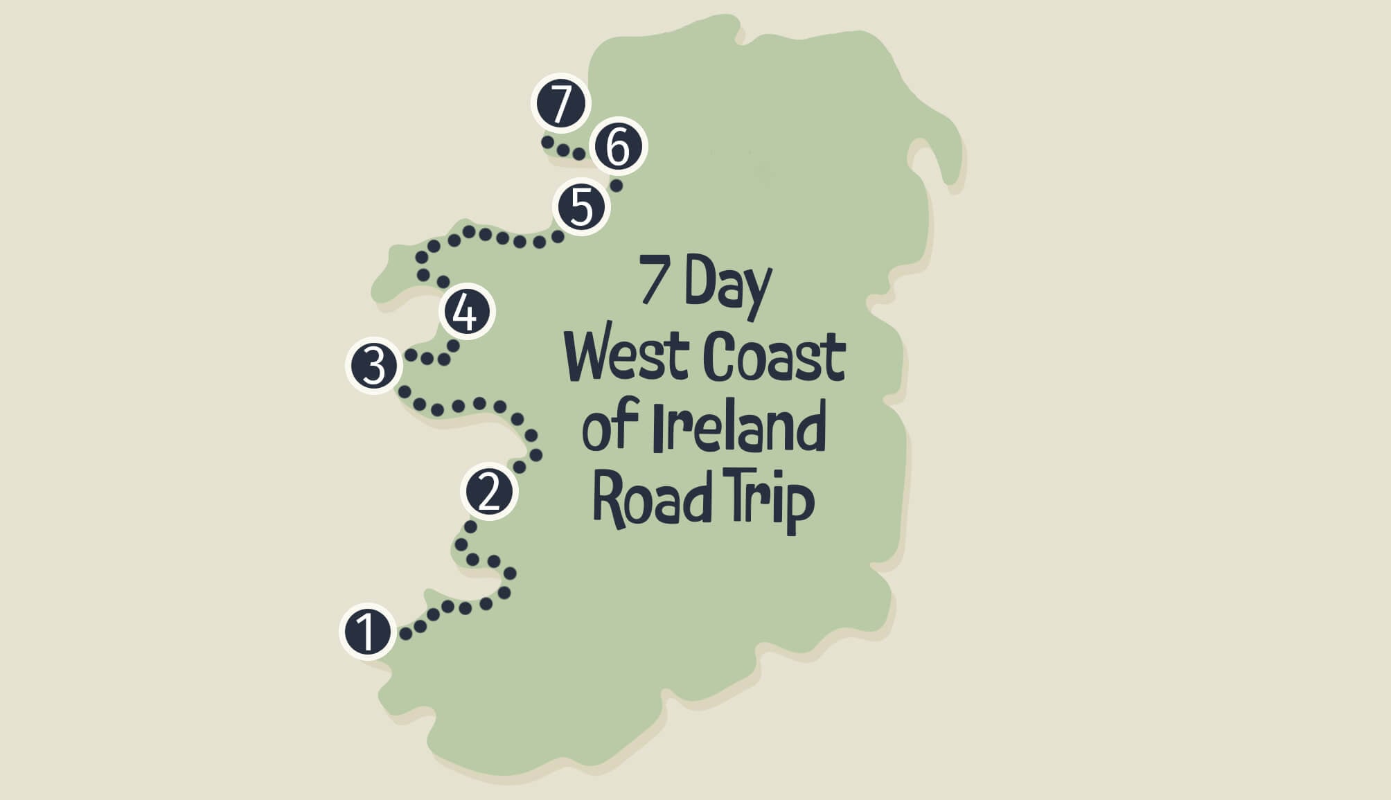
Itinerary overview:
- Day 1: Dingle. Today depends on your arrival time (stay in Dingle)
- Day 2: Loop Head (Doolin)
- Day 3: Galway City and Connemara (Clifden)
- Day 4: Connemara, Westport and Achill (Achill)
- Day 5: The North Mayo Coast and Sligo (Sligo Town)
- Day 6: Sligo (Donegal Town)
- Day 7: Depends when you need to leave. Ideally, the Donegal Coast (Donegal Town)
West Coast of Ireland itinerary overview
Take a minute to look over my West Coast of Ireland itinerary map above. As you can see, you’re travelling from one end of Ireland to the other, taking in a good chunk of the Wild Atlantic Way.
This is a huge amount of ground to cover in 1 week and you’re absolutely going to miss out on a lot as you’re passing through places so quickly, so keep that in mind.
1. Who this itinerary will work for
This route works best if you have 7 usable days on the ground and you’re not losing 2 of them to travel. It’s ideal if:
- A: You’re flying into Shannon and starting the 1st of your 7 full days in Dingle the following morning
- B: You depart late in the day on Day 7 (you’ll either be travelling back to Dublin/Shannon from Donegal/Dingle)
- C: You’re looking to fit as much as possible into your 7 days and you accept that that means changing accommodation each night
2. Who it absolutely won’t work for
- A: Those with 7 days only (i.e. you fly in on Day 1 and out on Day 7)
- C: Those looking to travel Ireland slowly
3. Getting around Ireland
You’ll need a car for this West Coast of Ireland road trip. See my guide to renting a car in Ireland along with my tips on driving in Ireland.
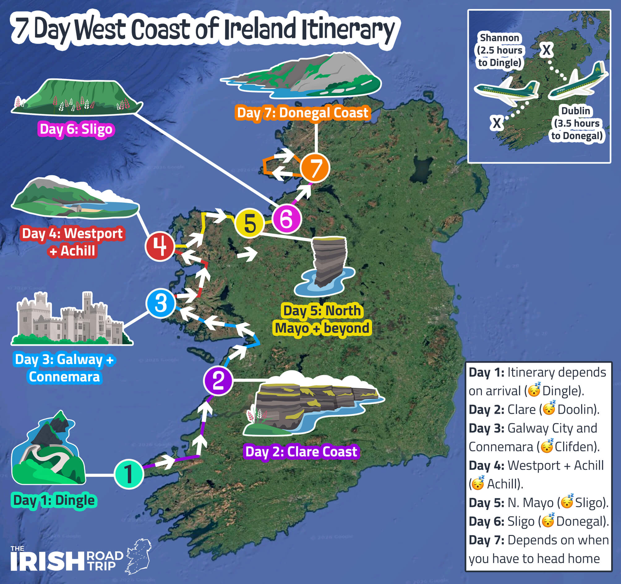
Day 1: Dingle

Photos by The Irish Road Trip
Day 1 of my West Coast of Ireland road trip takes you around the mighty Dingle Peninsula in County Kerry.
Ideally, you’ll have landed in Dublin or Shannon the day before and you’ll be arriving in Dingle fresh today.
Where to stay in Dingle on night 1
- Central stays: Dingle Benners (on Main Street close to everything) and the Dingle Bay Hotel (overlooking the harbour in the centre of town)
- My favourites: Greenmount House (elevated spot with bay views a 5-min walk to Main St.) and the Dingle Skellig (hotel with great facilities a 10-min walk from the centre)
1. The Dingle Peninsula drive

You’re going to be following the Dingle Peninsula Drive today, as outlined on my map above.
Now, I have the stops marked out from A to M, but you’ll likely need to change your first stop to be close to your starting point. I’m going to give you an overview of the route from Inch Beach, but change as needed.
2. Inch Beach

Inch Beach is a long, narrow sand spit stretching out into Dingle Bay and is one of the standout stops on the Dingle Peninsula.
There’s a large car park beside the strand with public toilets and, while there’s plenty of room outside of the peak months of the year, it fills up quickly on fine days.
The strand itself runs for roughly 5km, making it ideal for a long, uninterrupted walk with mountain and bay views in every direction. Sammy’s Café sits right by the beach, handy for a takeaway coffee or a post-walk feed.
A small roadside viewpoint nearby (here on Maps) offers sweeping views over the beach and surrounding coastline.
3. Minard Castle

The next stop is a 15 minute spin from Inch and it comes with a warning – take the road to it very handy!
Minard Castle was built in the 16th century by the FitzGeralds, and later fell to Cromwell’s forces in 1650 and has remained a dramatic Atlantic-side ruin ever since.
The drive up is fairly straightforward, though you’ll be navigating narrow country roads often shared with farming vehicles.
Fans of classic cinema might recognise the castle from the 1970s film ‘Ryan’s Daughter,’ where it was referred to as ‘The Tower.’
A warning: There’s loads of lovely round stones on the left side of the beach that you’ll likely wander across – go handy! Both myself and my friend nearly left with sprained ankles on our last visit!
4. Dingle Town for lunch and a stroll

Now, if you stayed in Dingle the night before, you’ll have likely already sauntered around it. If you haven’t, now’s your chance!
Dingle Town is a 15-minute spin from Minard Castle. Park up (there’s parking available near the harbour) and head off on your merry way.
I’ve made the map above for you to follow that takes in the best of the town. For lunch, Fish Box never disappoints!
5. The Slea Head Drive

When your belly’s full, it’s time to set-off on the Slea Head Drive – a scenic, 38km (24-mile) route showcasing many of the top attractions in Dingle.
Here’s a quick guide to the highlights along the way:
- Ventry Beach: A 4.5km Blue Flag beach
- Ceann Sleibhe and the White Cross: Two incredible viewpoints
- Radharc na mBlascaoidí: Panoramic views of Dunmore Head
- Coumeenoole Beach: A breathtaking beach with strong rip tides
- Dun Chaoin Pier: Launch point for the Blasket Island Ferry
- Ceann Sraithe: A famous Star Wars filming spot
- Clogher Strand: One of Kerry’s most beautiful beaches
6. Dingle for the night

When you’ve had your fill of Slea Head, nip back to your accommodation and chill for a bit. You’ve plenty to look forward to on the 1st night of your West Coast of Ireland road trip.
Dingle is a haven for superb food and outstanding traditional pubs, and you’ll sample the best of both tonight. I’ll give you my favourites below, but my guide to the best food in Dingle and the best pubs in Dingle offer more depth!
Where to eat in Dingle
- The Fish Box: Casual and consistently excellent. Try the Seafood Spice Box, the monkfish or the tasty tacos
- Out of The Blue: The menu changes daily depending on the catch. Expect lobster, monkfish, halibut and properly executed classics in a polished but relaxed setting
- Land to Sea: A step up for a special night. Seasonal tasting menus built around Kerry finest produce
My favourite pubs in Dingle
- Curran’s Bar: Trading since 1871 and still has the feel of an old general store. Character-filled and my favourite pint in the town
- Kennedy’s: Cosy, fire-lit and known for welcoming travelling musicians. A proper traditional pub
- Foxy John’s: One of Dingle’s most unique spots. Tools behind the bar, trad sessions often in full swing and a consistently good pint
Day 2: Loop Head and Doolin

Day 2 of my 7 day West Coast of Ireland itinerary takes you out of Kerry and up into Clare, with a mini car ferry journey to save you some time en route.
You’ll traverse the famous (or infamous…) Conor Pass in the morning and walk alongside the Cliffs of Moher in the evening.
Where to stay in Doolin on night 2
- Central stays: West Haven House (short stroll from McDermott’s Pub) and Cullinan’s Guesthouse (great reviews and right across from Fitzpatrick’s Bar)
- Our favourites: Doolin Inn (a stone’s throw from Fisher Street), Fiddle + Bow Hotel (boutique and very central) and Hotel Doolin (good value and nice and central)
1. Conor Pass

When you leave Dingle Town, take the scenic climb up towards Conor Pass.
It’s one of the highest mountain passes in Ireland and the views from the top are exceptional. The road does narrow significantly in sections, which can feel intimidating if you’re not used to tight, winding routes.
If you’d prefer to avoid the trickiest stretch, approach from the Dingle side and pull into the car park before the road narrows.
From here, you’ll get sweeping views down over the valley and lakes below, without needing to tackle the more challenging section of road.
2. Take the Tarbert Ferry to Clare

Courtesy Valerie O’Sullivan for Fáilte Ireland
From your previous stop, continue on to Tarbert, where you’ll board the Tarbert Ferry across the Shannon Estuary into County Clare.
The crossing itself is short and scenic, and it saves you from a long drive inland around the estuary. One thing to keep in mind is that tickets are open rather than timed, so during busy periods you may have to wait for the next available sailing.
Even with that small drawback, it’s a pleasant and slightly different way to travel, offering coastal views you wouldn’t otherwise see.
3. Coffee and cake in Kilrush
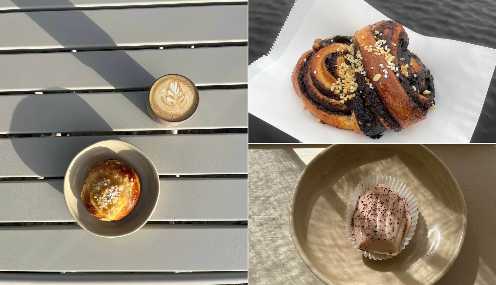
Photos via Beag Cafe on FB
When you depart the ferry in Killimer in Clare, take the short, 10-minute spin to the town of Kilrush and head straight for Beag Cafe.
Beag is a family-run café tucked into a character-filled corner house in Kilrush, blending traditional charm with a clean, modern feel.
They pour rich Calendar coffee from Galway and turn out a tempting lineup of house bakes – think sticky cinnamon buns, chocolate hazelnut swirls and fudgy wholemeal sea salt brownies fresh from the galley kitchen.
4. Loop Head or on towards Doolin
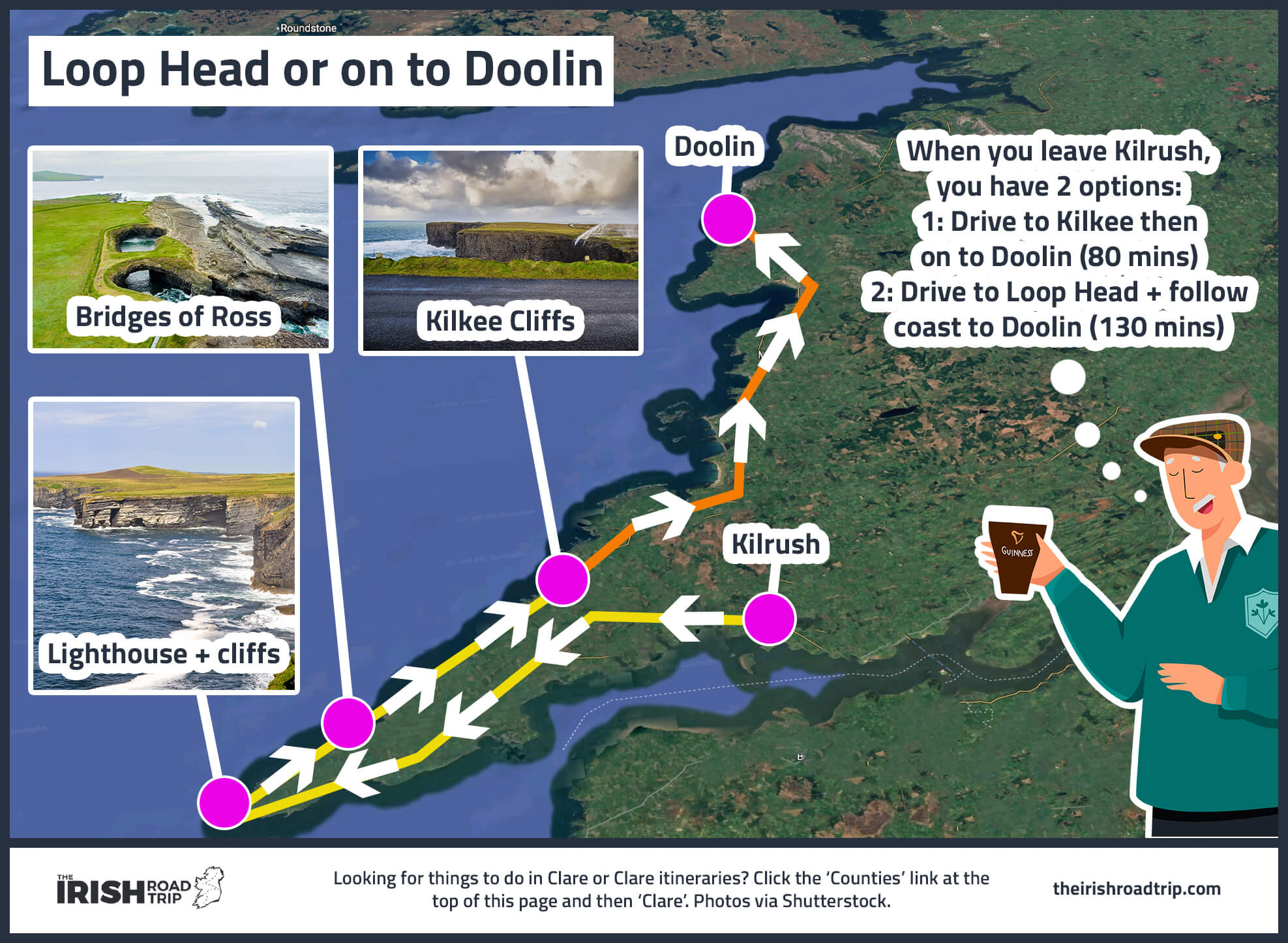
When you leave Kilrush, you have 2 options, depending on how much driving you want to do:
- Option 1 (80 mins of driving): Head straight to Kilkee, do the Kilkee Cliff Walk, followed by lunch in Lahinch and then on to Moher
- Option 2 (130 mins of driving): Head to Loop Head Lighthouse, see the cliffs, stop at the Bridges of Ross, then head to Moher
5. The Cliffs of Moher

Regardless of which option you chose, your final stop on Day 2 of this West Coast of Ireland itinerary is the Cliffs of Moher – the most popular of the many things to do in Ireland.
On-site, you’ll find a visitor centre, 800 metres of paved walkways with various viewing areas, and the historic O’Brien’s Tower.
In my opinion, the visitor centre isn’t particularly special, but with the Cliffs of Moher Experience, you’ll get access to all three.
6. Doolin

Your base for the night is Doolin, a 15-minute drive from Moher. I’ve created a little map for you above just so you’re aware of the main landmarks.
Two of the highlights are Doonagore Castle and Doolin Cave.
Doonagore Castle is a privately owned 16th-century tower house near Fisher Street. There’s mighty views but very limited space to pull-in.
Doolin Cave, home to Europe’s longest free-hanging stalactite, offers a 45-minute guided tour showcasing its 70,000-year-old natural wonder and surrounding farmland trail.
7. Doolin for the night

Night 2 of this West Coast of Ireland road trip ends in Doolin – a colourful little town that’s well known for its trad music scene. Here are some great places to eat and drink:
- Restaurants in Doolin: Russell’s Seafood Bar focuses on fresh local catches while McDermott’s Pub does great pub grub
- Pubs in Doolin: The four main pubs are spread out, so you’ll likely end up in whichever is closest to where you’re staying. If you’re in the mood for live music, Gus O’Connor’s on Fisher Street is usually a safe bet
Day 3: Galway City and Connemara

Photos via Shutterstock
Day 3 of my West Coast of Ireland road trip takes you up along the coast of the Burren and on to Galway City before moving out into Connemara.
While this is a busy day that packs in plenty, there’s less than 3 hours of driving needed for the entire day.
Where to stay in Clifden on night 3
- Budget: Errismore House is right in the town and always great value
- Mid-range: Alcock & Brown Hotel is in the town and has excellent reviews
- Unique: Abbeyglen Castle is good value a short walk from the town
1. The Burren Scenic Drive

The stretch from Doolin towards Galway follows part of the Burren Scenic Drive – a route that threads between limestone hills on one side and the Atlantic on the other.
You won’t be completing the full loop shown on the map; instead, you’ll follow the coastal section as far as Ballyvaughan before heading on to Galway.
As you hug the shoreline, keep an eye out across the water – on a clear day you’ll see the Aran Islands sitting low on the horizon.
A worthwhile stop along this stretch is Fanore Beach, a wide sandy strand backed by dunes and Burren hills. It’s a great place to stretch the legs and, if the weather behaves, dip your toes in for a quick paddle.
2. Dunguaire Castle

Dunguaire Castle sits on the edge of Galway Bay, around 35 minutes from Galway City, and was originally built in 1520 by the O’Hynes clan.
In 1912, it was bought and restored by writer Oliver St. John Gogarty, who turned it into a gathering place for some of Ireland’s literary heavyweights, including W.B. Yeats and George Bernard Shaw.
Few castles in Ireland boast a setting quite like it – perched right on the water with the Burren landscape stretching behind.
Local folklore adds a final layer of charm: it’s said that if you stand at the gate and ask a question, you’ll have your answer before the day is out.
3. Galway City

It’s around a 40-minute drive from Dunguaire Castle into Galway City. Once you arrive, your first job is sorting parking. There are several options dotted around the centre, but Q-Park Hynes Yard is a handy, central choice.
After that, it’s time for lunch. Galway is packed with great lunch spots, but Blakes Bar is a solid option for hearty pub grub, while Zappis is a reliable shout if you’re in the mood for Italian.
With the car parked and a feed had, you can explore on foot. Galway is compact, lively and very easy to navigate. I’ve put together a self-guided Galway walking tour to help you make the most of your time, using the map above to guide you.
4. The drive through Connemara

It’s about a 75-minute drive from Galway City to Clifden along the N59, cutting straight through the heart of Connemara. In truth, you could spend the better part of a week exploring this region alone – but with limited time, you’ll need to be choosy.
Unless you’re particularly eager to see Aughnanure Castle or the Quiet Man Bridge, I’d prioritise the other stops on my map above before continuing on to Clifden.
The drive itself is part of the experience. You’ll pass through the traditional village of Oughterard and continue towards Maam Cross, with rugged mountains, vast lakes and sweeping stretches of moorland unfolding around you.
5. The Sky Road

Your final stop of the day is the Sky Road, which is one of the most rewarding drives on this West Coast of Ireland itinerary.
This is a breathtaking 16km loop that begins in Clifden, making its way around the Kingston peninsula along a coastal road with stunning views.
Along the way, the loop passes by Clifden Castle, a ruined manor house overlooking the water.
After the castle, the Sky Road deviates into two routes which join up again later, the lower road which has close-up views of the sea, and the upper road, which has views over the bay.
6. Clifden for the night
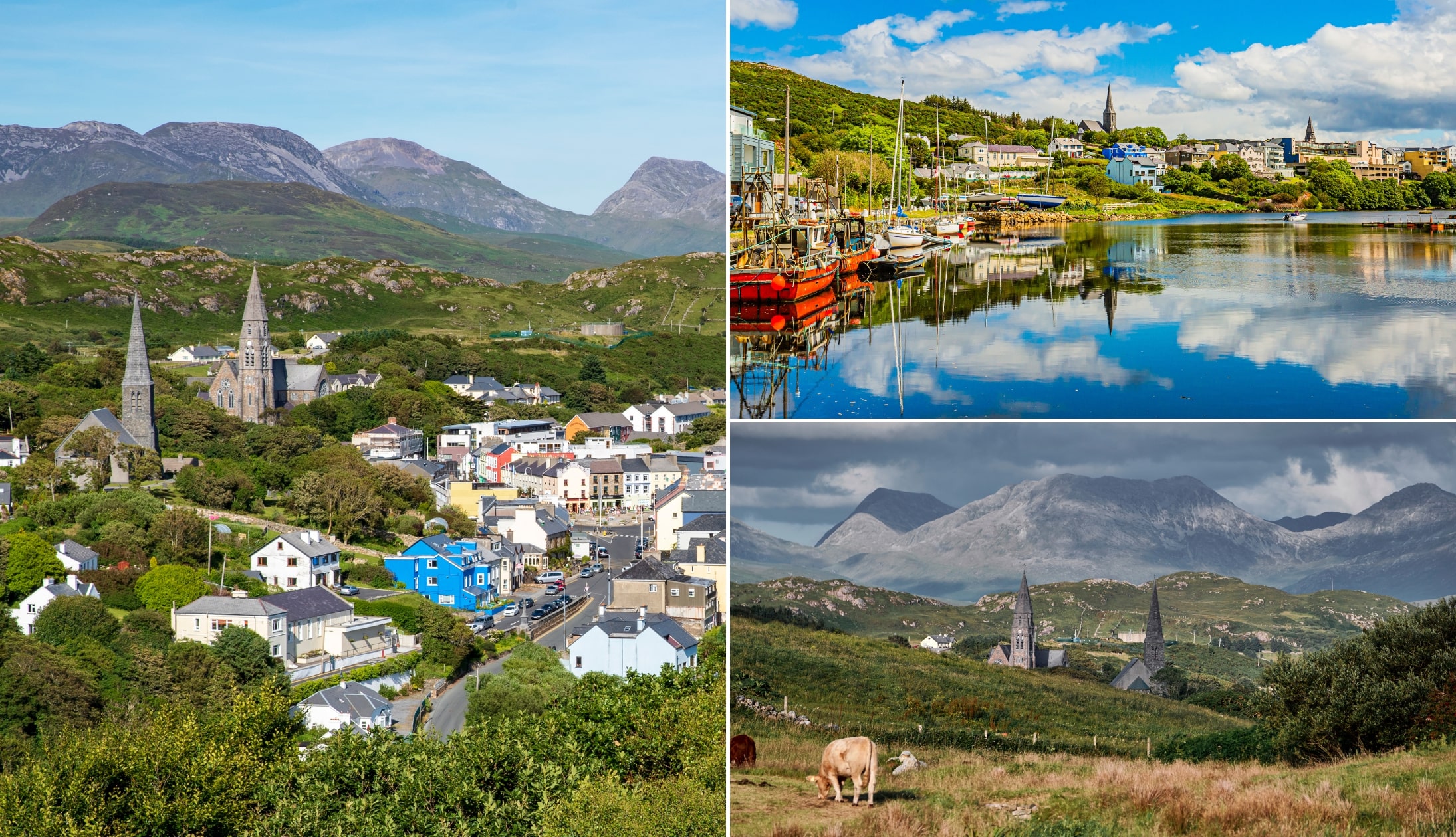
Photos via Shutterstock
Night 3 of your West Coast of Ireland road trip finishes in Clifden Town.
This is a lively tourist town during the summer months but it tends to be much quieter outside of peak season.
- Places to eat: Guys Seafood Bar and Off The Square
- Pubs: Lowry’s Music & Whiskey Bar and McGraths Pub
Day 4: Connemara, Westport and Achill

Photo by The Irish Road Trip
Day 4 of this West Coast of Ireland itinerary sees you take the spin from Galway into Mayo with a total drive time of just under 3 hours.
You’ll visit Kylemore Abbey, travel through the Doolough Valley, explore Westport and then head onto Achill Island for the night.
Where to stay on Achill on night 4
Personally, I think Stella Maris Luxury Bed and Breakfast is the best place to stay on Achill, because:
- It’s located right across from the cliffs at Keel and the views are mighty
- The standard of accommodation is excellent
- It’s a short walk to the The Amethyst Bar
1. Kylemore Abbey
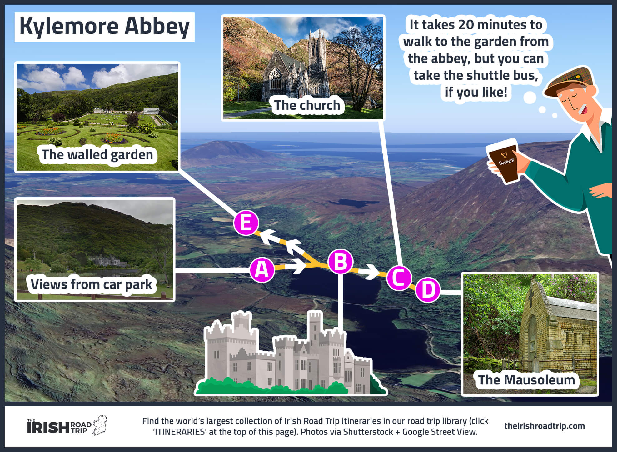
It’s a short 25-minute drive to Kylemore Abbey, one of the most visited attractions in Galway.
Kylemore Abbey is a striking Benedictine monastery dating back to the 1920s, set against a backdrop of mountains on the shores of Pollacapall Lough.
The restored lower floors are open to visitors, along with the beautifully maintained Victorian Walled Garden.
The wider estate also includes a Neo-Gothic church and several woodland and lakeside walks that are well worth allowing time for. Give yourself 1.5 hours here.
2. Killary Fjord
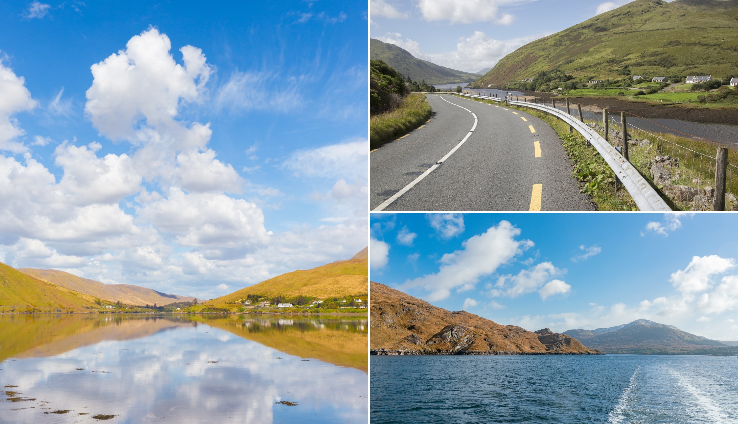
Photos via Shutterstock
Your 2nd stop of the day is this viewpoint, around 15 minutes from Kylemore Abbey.
From here, you’ll be treated to sweeping views over Killary Harbour, Ireland’s only fjord.
On a clear day, you may spot the famine-era potato ridges etched into the hillsides across the water.
After soaking up the views, follow the road into Leenane, one of the most charming little towns along the West Coast of Ireland.
3. Aasleagh Falls

Aasleagh Falls is less than 10 minutes from Leenane. There are two small car parks nearby, and it’s only a short walk to reach the cascade.
Please do take careful note of my warning above about the bad bend at the parking area, as there is a terrible blind spot here.
Now, please also take note that there’s no formal pathway right to the falls, so expect to cross uneven or muddy ground.
This is a beautiful spot, particularly after rainfall when the water is in full flow.
4. Doolough Valley

After you leave the falls, you’ll be making your way to Louisburgh via the outstanding Doolough Valley.
This stretch of road is one of the most scenic drives in Ireland, and you’ll often find the place virtually empty.
The Doolough (‘Black Lake’ in English) Valley is a scenic corner of Mayo where unspoiled scenery collides with raw, isolated beauty.
Doolough Valley is also the site of the Doolough Tragedy of 1849, when starving famine victims walked this remote stretch in search of relief and many perished along the roadside.
5. Westport for lunch
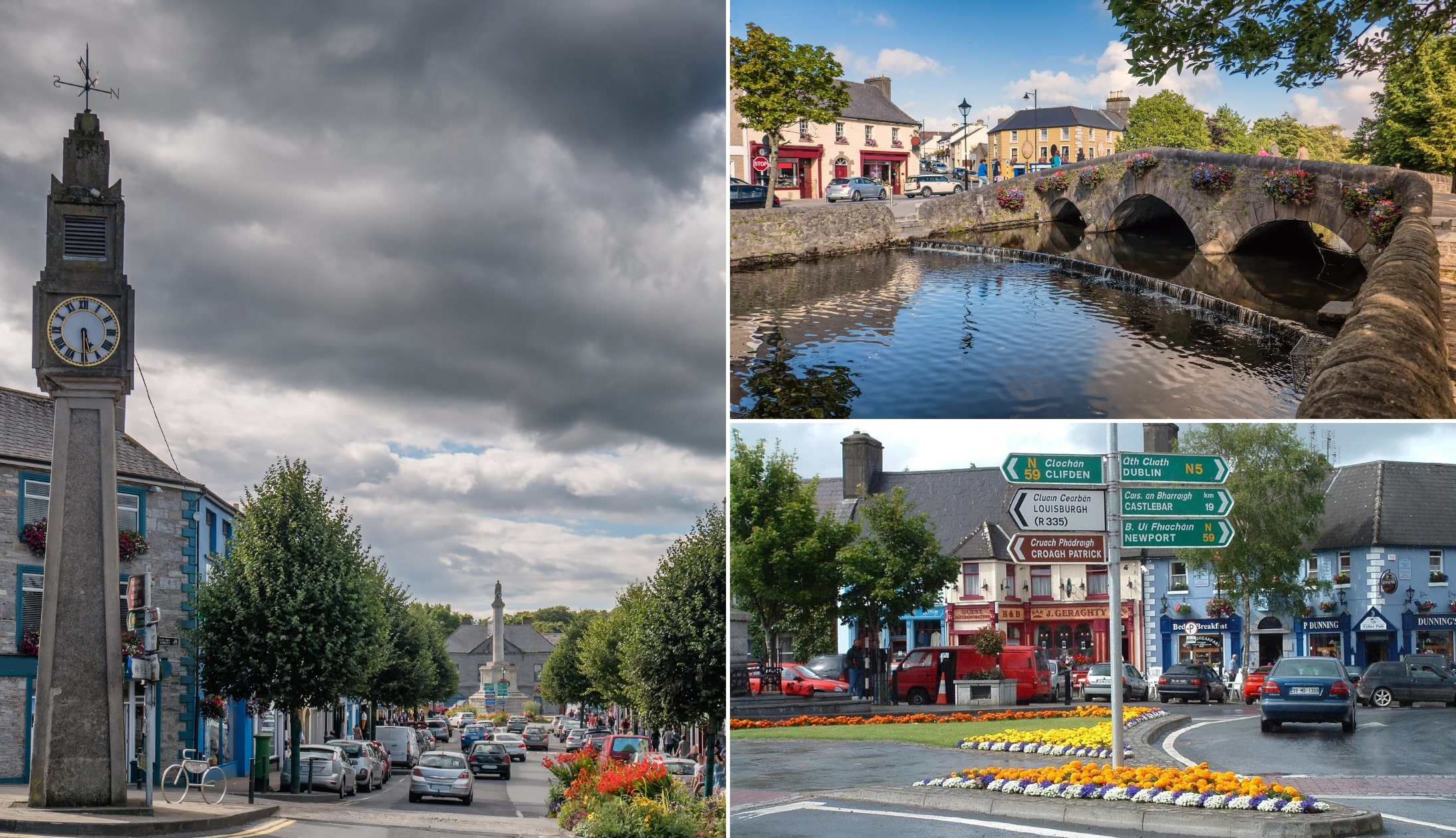
Photos via Shutterstock
Westport is a 30-minute spin from Louisburgh. This is a lively and colourful town that’s perfect for a relaxed wander. I’ve put together a short walking route that covers many of the highlights.
The route is roughly 1.3km long and takes about 20 minutes. Here’s what you’ll see:
- Stop 1 (coffee): Start at This Must Be The Place for a coffee
- Stop 2 (The Clock): Built in 1947, Ireland’s only art deco municipal clock, nicknamed ‘The Four Faced Liar’
- Stop 3 (The Octagon): The town’s best-known landmark, built between 1843 and 1845 with a statue of St. Patrick at the top
- Stop 4 (Doris Brothers’ Bridge): A beautiful stone bridge spanning the river
- Stop 5 (The Mall): A scenic riverside stretch passing St. Mary’s Church
- Stop 6 (Bridge St): Finish among the colourful shopfronts
6. The Atlantic Drive

You’re going to be tackling the Atlantic Drive on Achill Island, next. For this trip, I’d recommend heading straight for Achill Sound and following the itinerary as follows:
- Cloughmore Viewpoint: A rocky, scenic viewpoint overlooking Achillbeg Island
- White Cliffs of Ashleam: A dramatic Wild Atlantic Way Discovery Point featuring jagged cliffs battered by the waves
- Dooega Bay Beach: A peaceful, less-crowded beach with soft sands, rock pools, and stunning views
- Minaun Heights: A 466m-high viewpoint offering one of the best panoramic views on this Wild Atlantic Way route
- Keel Beach: A vast sandy beach perfect for surfing, kayaking, and coastal walks
- Keem Beach: Iconic golden-sand beach surrounded by green hills
- Golden Strand: A crescent-shaped sandy beach in Dugort
- Achill for the night: Take it handy
Day 5: The North Mayo Coast and Sligo

Photos via Shutterstock
Day 5 of this West Coast of Ireland road trip day blends ancient history with rugged Atlantic scenery as you explore North Mayo before crossing into Sligo.
Expect cliff-top viewpoints, monastic ruins and small seaside towns, finishing the evening in lively Sligo Town (total drive time is around 3 hours).
Where to stay in Sligo on night 5
- Budget: Station Lodge (good value and nice and central)
- Medium: Clayton Hotel (short walk to town and it has a leisure centre)
- Highish: The Address (boutique hotel at the heart of the action)
1. The Ceide Fields or a coastal ramble

Photo left and bottom right: Michael Mc Laughlin. Top right: Alison Crummy. Via Failte Ireland
It’s around a 1.5-hour drive from Achill to the North Mayo coast, so today is one where you’ve choices to make depending on how much time you want to spend in the car/what you feel like doing:
Option 1: The Céide Fields (the least strenuous option)
Head east to explore the Céide Fields – a 6,000-year-old Neolithic landscape perched above the Atlantic. It’s the oldest known field system in the world, with ancient stone walls, tombs and dwelling sites hidden beneath the bog. There’s an excellent visitor centre, guided tours onto the peatland and sweeping cliff-top views.
Option 2: The Mullet Peninsula & Erris Head Loop (5km/2 hours)
Stay west and explore the wild Mullet Peninsula instead. The Erris Head Loop Walk offers dramatic cliff scenery, sea stacks and uninterrupted Atlantic views. It’s remote, rugged and far less visited than many Wild Atlantic Way stops.
Option 3: Carrowteige & Benwee Head (12km/4 hours/tough)
Follow the north Mayo coastline towards Carrowteige and tackle the Benwee Head walk. This route delivers big cliff views and a real sense of isolation, especially on a clear day. It’s quieter, raw and the landscape is unspoiled.
2. Dun Briste
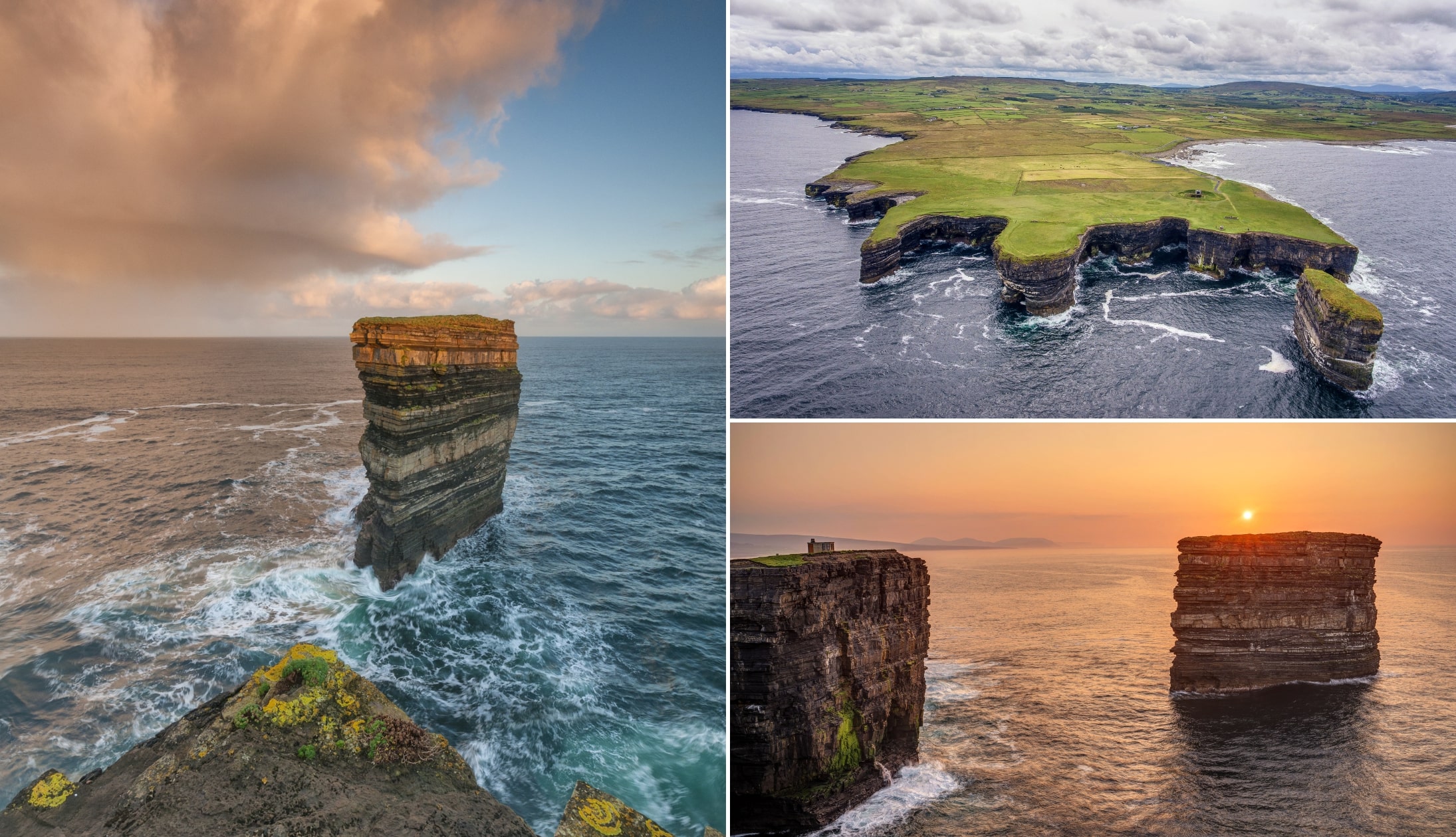
Photos via Shutterstock
From the Céide Fields, it’s a 20-minute drive to Downpatrick Head (around 55 minutes from Belmullet), where you’ll find the dramatic Dun Briste sea stack.
Rising 45 metres from the Atlantic and sitting just offshore, it’s home to seabirds including puffins and kittiwakes.
There’s a large car park at the headland and a 15-minute walk brings you to the cliff edge. The layered rock and crashing waves make this one of Mayo’s most striking sights.
While you’re here, you can also see the WWII EIRE 64 lookout post, St Patrick’s Church and the blowhole known as Pul Na Sean Tinne. Just please make sure to stay well away from the edge!
3. Killala for lunch
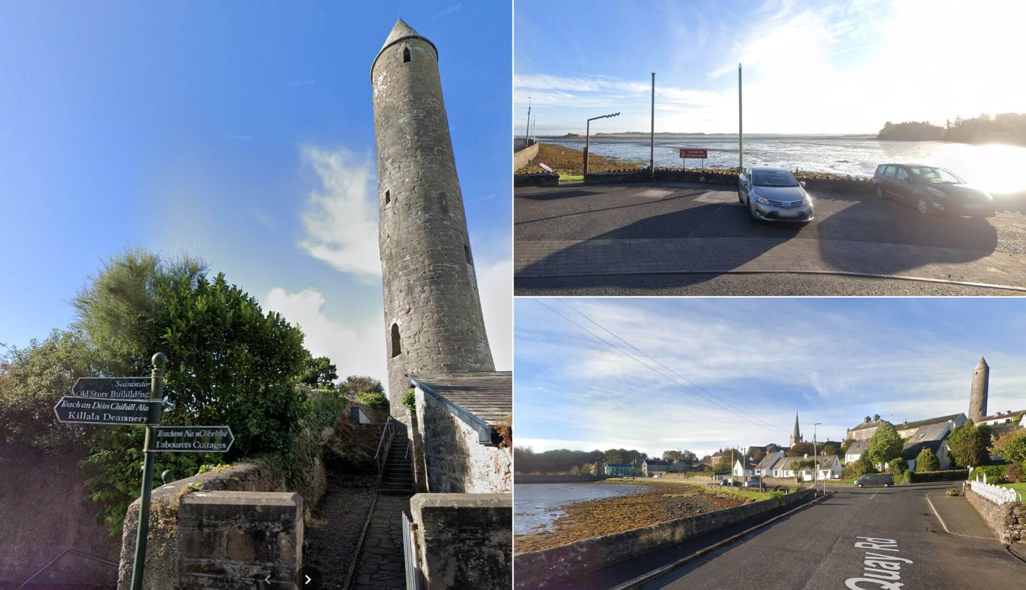
Photos via Street View
Take the 20-minute drive to Killala, next. This is a small harbour town with deep historical roots. It was founded as an early Christian settlement linked to Saint Patrick, and its 12th-century round tower still stands as a reminder of its ecclesiastical past.
The town also played a key role in the 1798 Rebellion, when French forces landed nearby and briefly took control of the area.
Today, it’s a quiet coastal stop where visitors can enjoy views over the bay. For lunch, head to the Village Inn for straightforward pub grub in a comfortable setting before continuing on.
4. Moyne Abbey
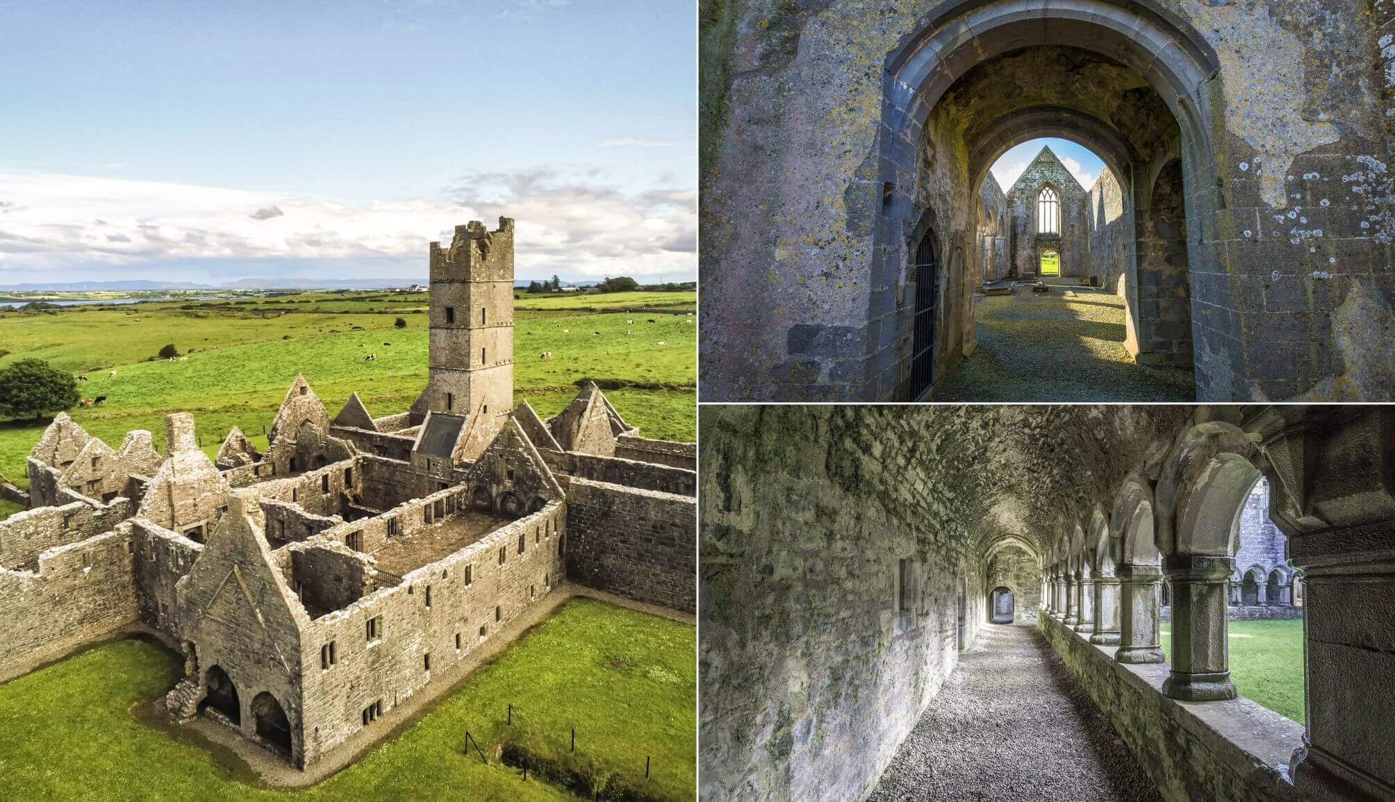
Photos via Shutterstock
Roughly 5 minutes away, Moyne Abbey is one of Ireland’s most impressive Franciscan friaries. Founded in 1460, it once served as a major centre of learning for young Franciscans.
Although now roofless, much of the late Gothic structure remains intact, including its square tower, cloisters and even 16th-century graffiti etched into the stone.
It’s slightly tucked away off the R314 north of Ballina, but the detour is well worth it.
5. Rosserk Friary
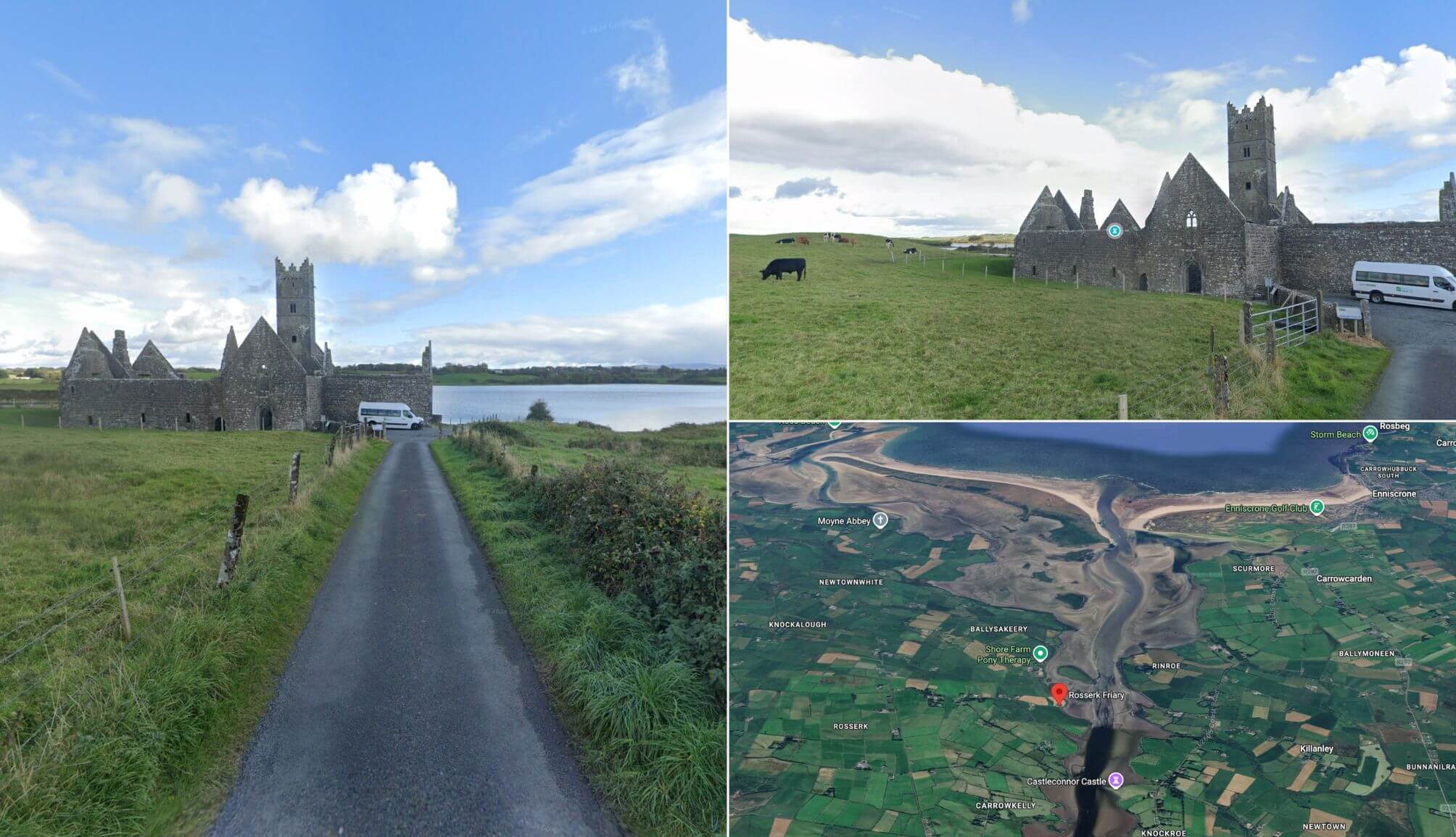
Photos via Street View
Rosserk Friary is a 10 minute drive from Moyne Abbey and you’ll find it set quietly along the River Moy. It dates to around 1441 and was founded for the Franciscan Third Order. Today, it’s one of the best preserved friary ruins in Ireland.
The church is late Irish Gothic in style, with a single nave, south transept chapels and a bell tower over the chancel arch. Inside, you’ll still see carved stonework, including a detailed double piscina with angels and symbols.
It was burned in 1590 during the Reformation, likely by Sir Richard Bingham. Allow 20 to 30 minutes. It’s compact, atmospheric and rarely busy. If you like ruins, this is worth the short detour.
6. Enniscrone
Photos via Shutterstock
Enniscrone is a laid-back seaside town known for its long sandy beach and dunes, a 30-minute drive from Rosserk Friary.
It’s a good spot to stretch the legs before the final drive to Sligo, especially if the tide is out and the beach opens up into a vast expanse of sand.
Enniscrone is known for its 5km stretch of golden sand running along the coast. In fact, the name, Enniscrone is thought to derive from the Irish meaning “the island on the sandbank in the river”.
7. Sligo Town for the night

Photos left and bottom right: The Irish Road Trip. Top right via McLynn’s
Day 5 of this 7 day West Coast of Ireland itinerary comes to an end in Sligo Town, a 45-minute drive from Enniscrone.
- Restaurants in Sligo: Hooked for delicious Irish and international food or Coachlane for seafood and steaks
- Pubs: Hargadon Bros (dating back to 1868), Thomas Connolly (the oldest in Sligo Town) and McLynns Bar (great Guinness and live tunes)
Day 6: Sligo

Licensed from Paulo Henrique Pigozzi
You’ve had a lot of driving over the last few days – today, you’ll have less than 1.5 hours of car time you’ll be happy to hear!
Day 6 mixes culture and coastline as you explore some of Sligo’s best-known landmarks before making your way into Donegal. Expect abbey ruins, waterfalls, mountain backdrops and a scenic coastal drive to finish.
Where to stay in Donegal Town on nights 6 and 7
- Budget: Heeneys Lodge B&B (superb reviews and a 5-minute spin from town) and Ros Dún House (top reviews and a 3-minute ramble away from the town)
- Mid-range: Central Hotel and The Gateway Lodge (both are right in the town and make a great base to explore from)
- Luxury: Lough Eske Castle (one of Ireland’s top hotels a short drive from town) and Harvey’s Point (gorgeous lakeside 4-star just outside of town)
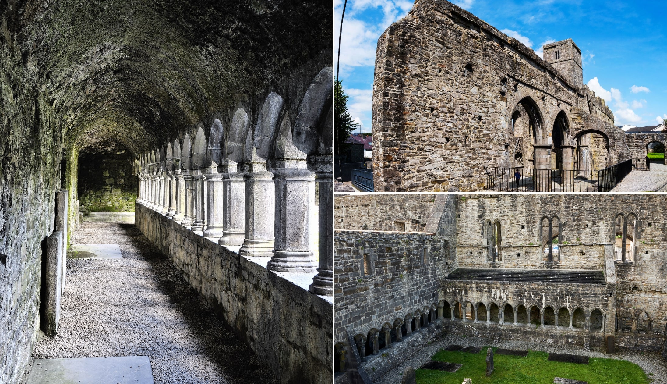
1. Sligo Town
Photos via Shutterstock
You’ll wake up in Sligo Town this morning, so take your time, check out and go in search of a decent coffee before you start exploring.
If you want to sit in somewhere central, Lyon’s Café is a great shout. They do a great cup of coffee along with cakes, scones and solid breakfast options if you’re after something more filling.
If you’re just grabbing a takeaway, I’d recommend Rover Coffee Lab. It’s small, no-nonsense and they pour a very memorable drop.
Once you’re sorted, make your way to Sligo Abbey and have a wander around one of the town’s most impressive medieval ruins.
2. Drumcliffe Church and WB Yeats Grave
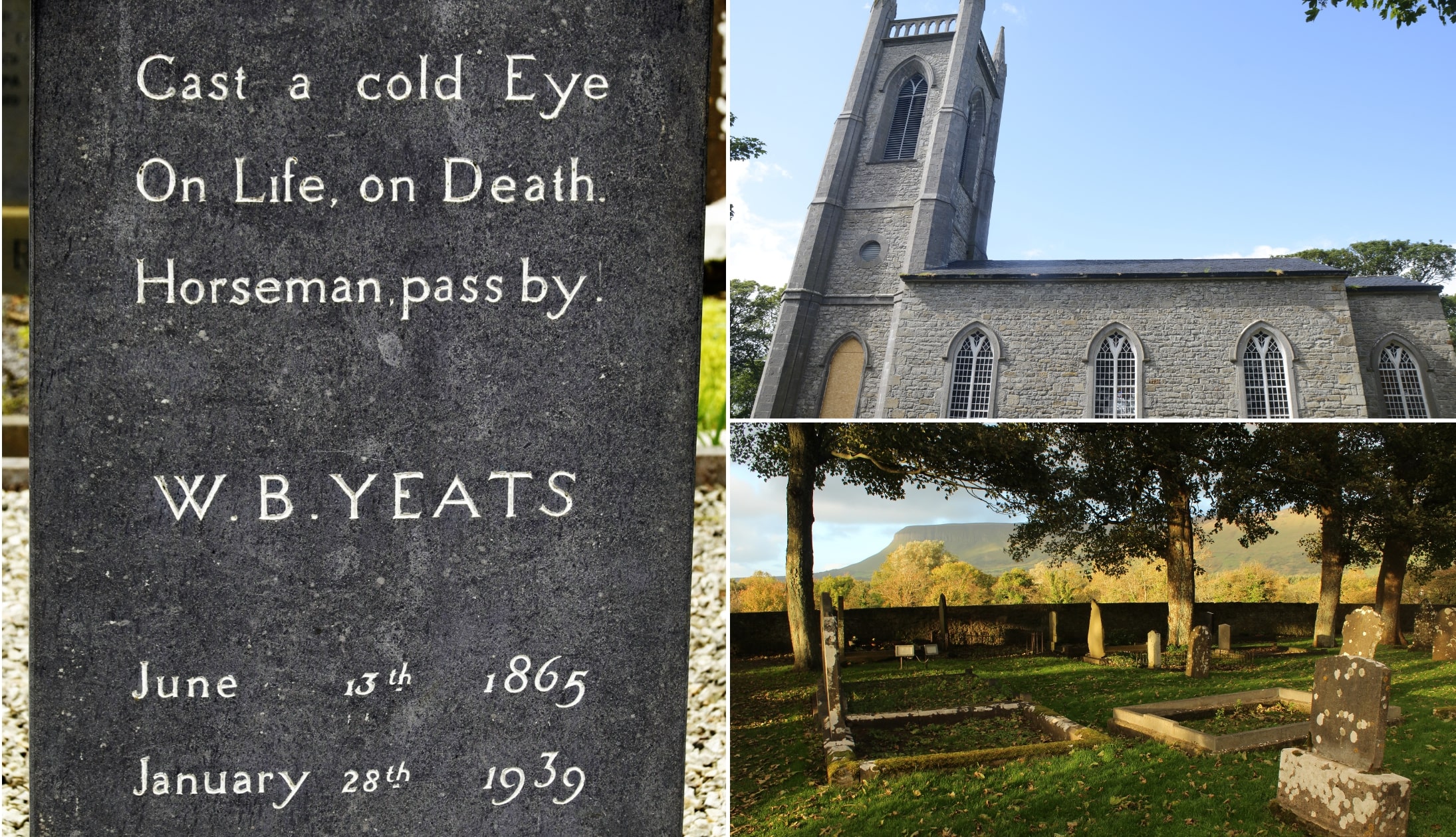
Photos via Shutterstock
Drumcliffe Church, set beneath the striking profile of Benbulben, is best known as the final resting place of W.B. Yeats (15-minute drive from the town).
The poet’s simple grave, marked with the line “Cast a cold eye on life, on death, horseman, pass by,” draws visitors from around the world.
Although Yeats died in France in 1939 and was initially buried there, his remains were later reinterred here after a complicated post-war exhumation.
Beyond the grave, the site itself is steeped in history, dating back to a 6th-century monastery, with an impressive 11th-century high cross and the stump of a round tower still standing.
3. Glencar Waterfall
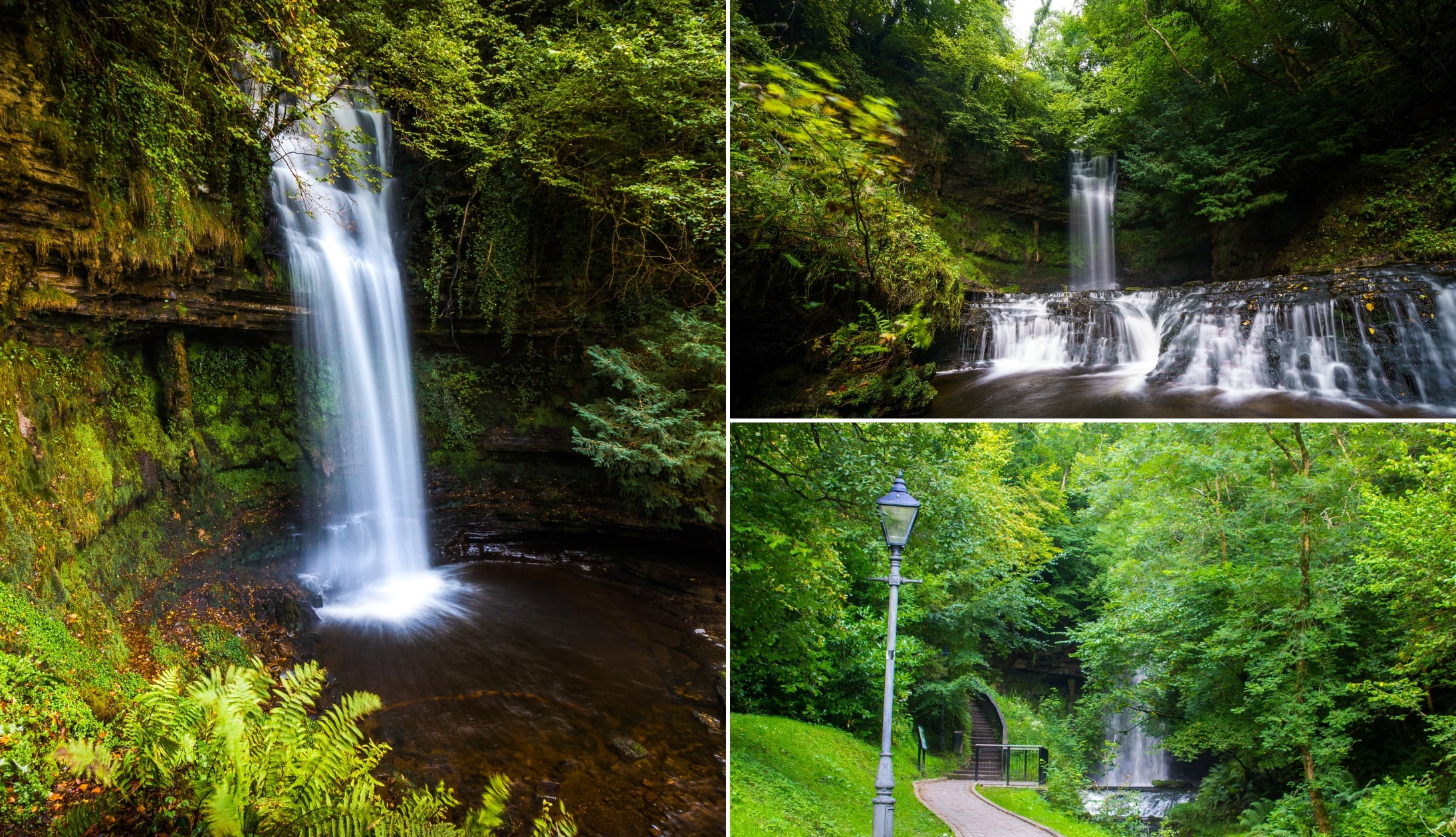
Photos via Shutterstock
From Drumcliffe Church, it’s a 20-minute drive over the border into County Leitrim to the Glencar Waterfall car park, where you’ll also find public toilets.
Tucked into woodland just north of Glencar Lough, Glencar Waterfall isn’t the tallest cascade in Ireland, but it’s easily one of the most atmospheric.
Water spills 50ft over dark rock into a pool framed by ferns and moss, creating a scene that feels almost staged.
It’s easy to see why W.B. Yeats immortalised it in The Stolen Child. The walk from the car park takes a very leisurely 5 – 10 minutes.
4. Benbulben Forest Walk
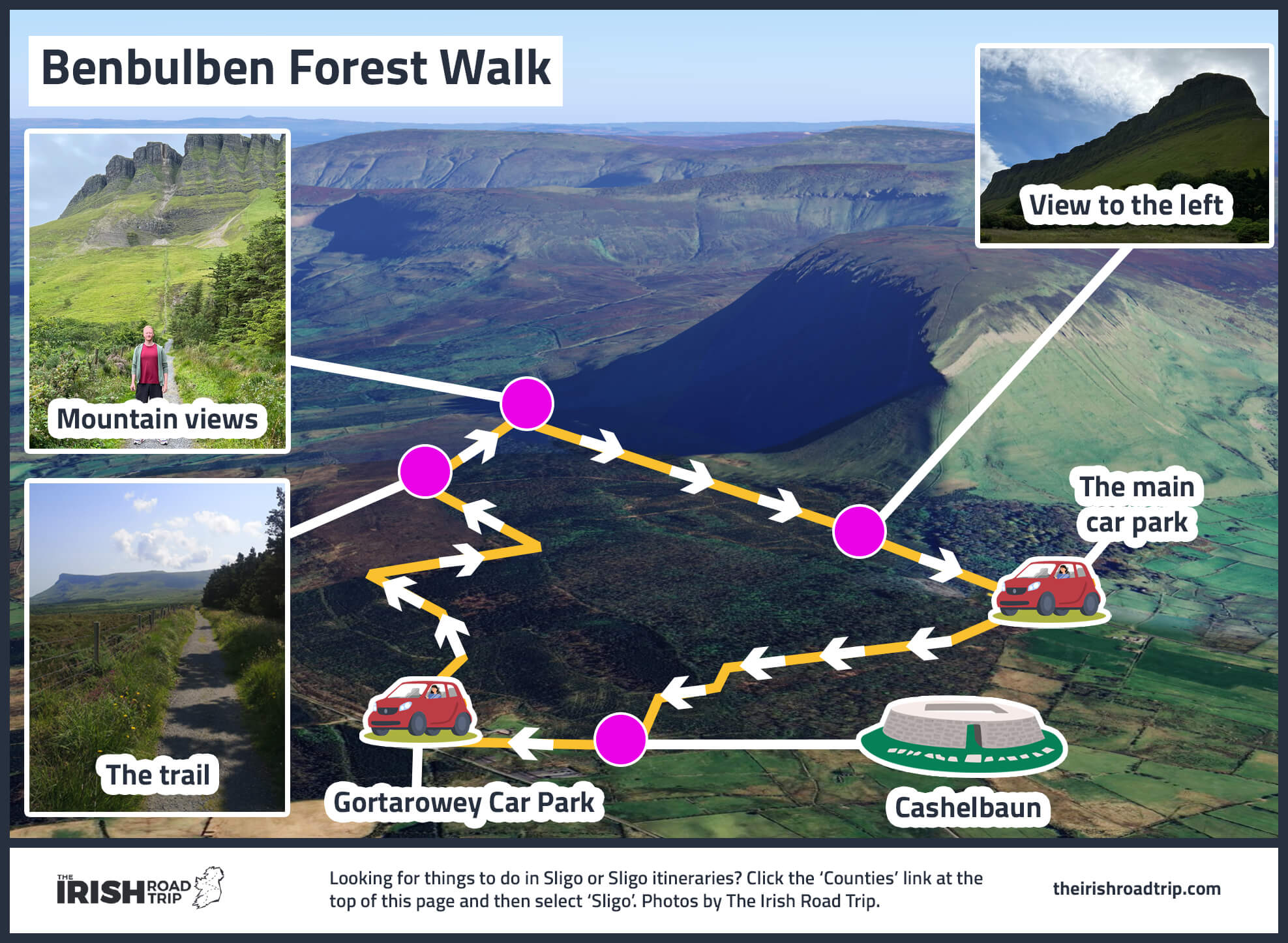
The starting point for the Benbulben Forest Walk is a 15-minute drive from Glencar.
Coming in at a breezy 5.5km, this Benbulben walk should take you around 1.5 hours to complete.
Add on a bit of time if you want to gawp at the mountain or take in the sea views.
As this ramble doesn’t actually involve climbing the mountain, the trail is quite flat and should be no bother for those with even a medium-level of fitness!
5. Lunch
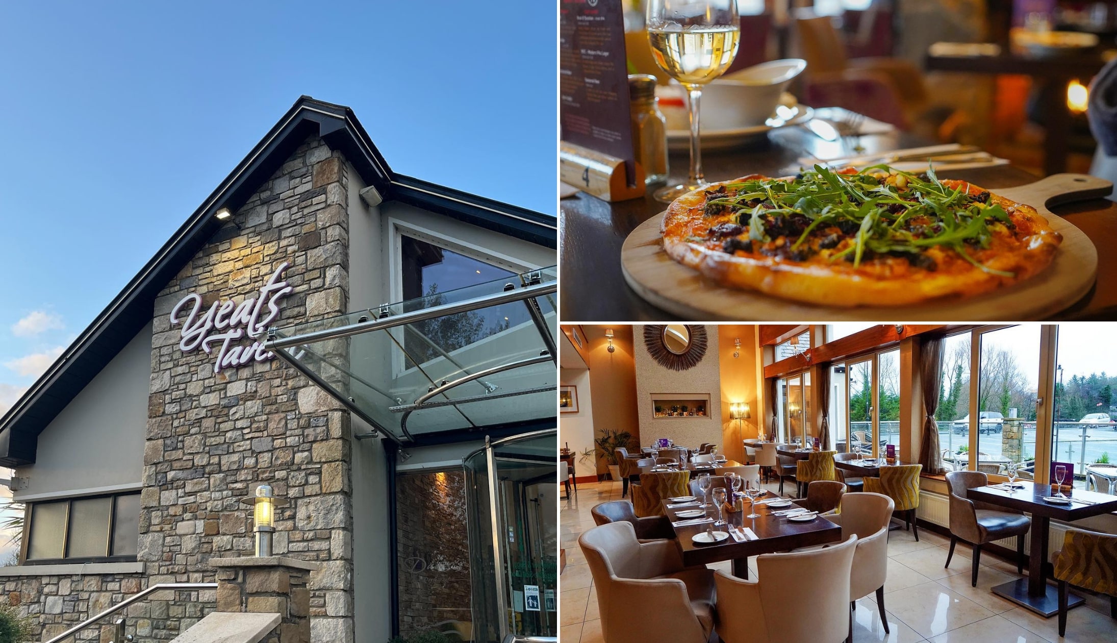
Photos via Davis’ Restaurant on FB
When you finish your stroll, take the 10-minute drive to Davis’ Restaurant & Yeats Tavern. This is one of my favourite spots outside of Sligo Town for a decent lunchtime feed.
There’s a fine big car park and it’s generally easy to grab a table. Expect solid, well-executed Irish classics with a focus on fresh, locally sourced ingredients – think seafood, hearty mains and proper comfort dishes done right.
6. The Gleniff Horseshoe drive
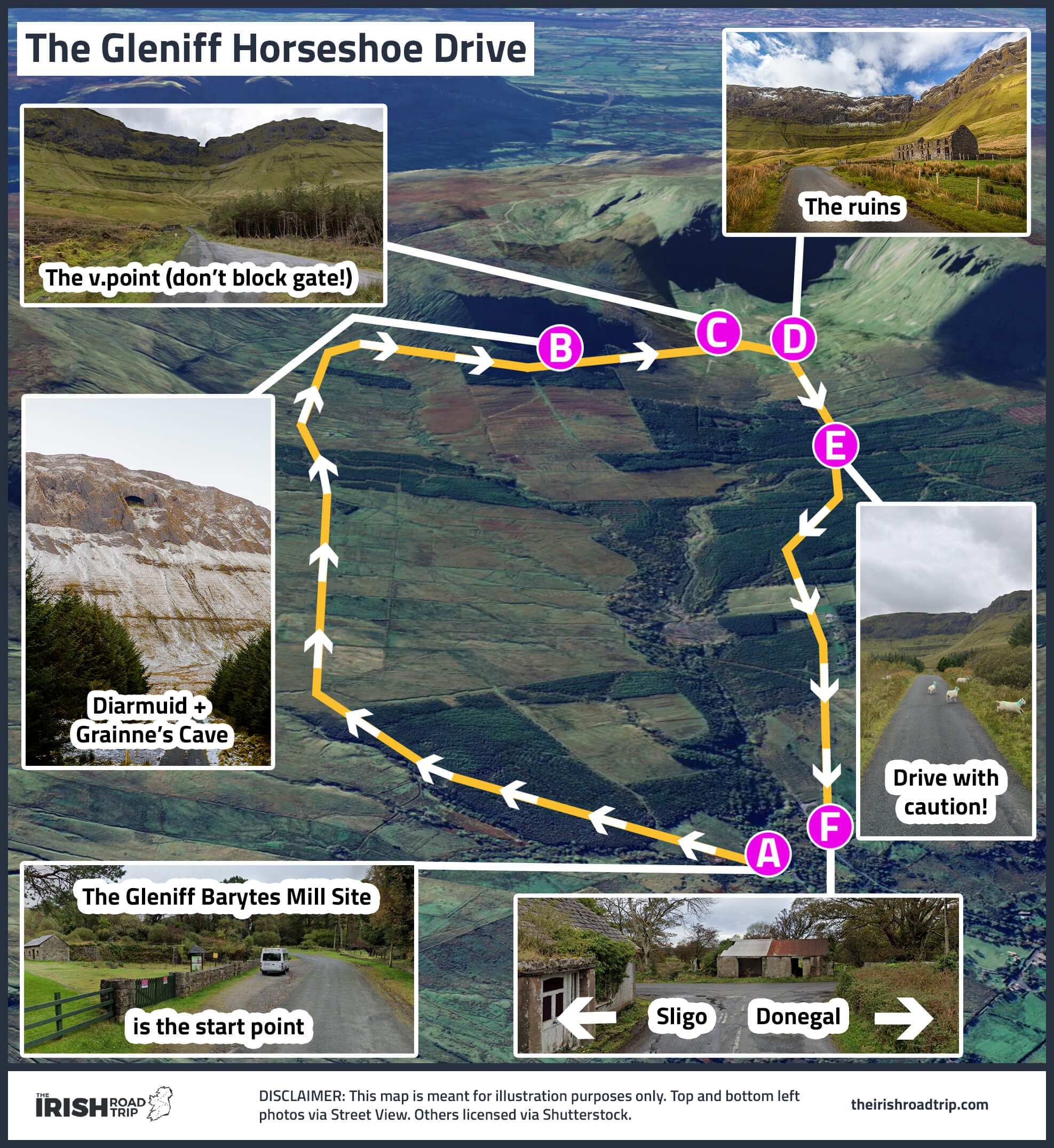
After lunch, it’s a 15-minute drive to the starting point for the scenic Gleniff Horseshoe Drive. Starting and finishing in Cliffoney, this 20km loop winds through dramatic scenery beneath the Dartry Mountains.
Along the way you’ll spot megalithic monuments, rugged hillsides and the cave known as Grainne and Diarmuid’s Cave high on the slopes. Keep an eye out for Benwiskin, the wave-shaped mountain guarding the valley entrance.
7. Bundoran

Bundoran is a handy 20-minute spin from where you finished the drive. When you arrive, park near the tourist office and follow the Rougey Cliff Walk.
This 4km coastal trail takes about an hour and delivers sweeping Atlantic views (you can find parking around here on Google Maps).
Along the way, you’ll pass unusual rock formations and landmarks tied to Irish folklore. It’s an easy, scenic way to break up the drive before pushing on to Donegal.
8. Donegal Town for the evening
Photos via Shutterstock
Donegal Town is a handy 30-minute spin from Bundoran. Check-in to your accommodation and chill for a bit. When you’re ready-to-rock, head out into the town.
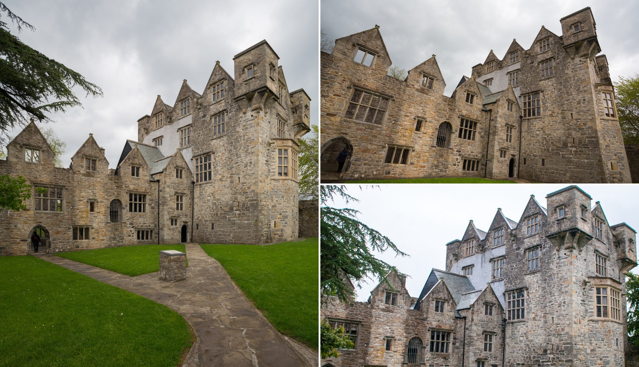
It’ll likely be late in the evening at this point, but it’s worth taking a stroll past Donegal Castle to admire its exterior.
When Donegal Castle was built in 1474 by the O’Donnell clan, it would have been one of the most formidable strongholds in the northwest.
Places to eat in Donegal Town
- Olde Castle Bar & Red Hugh’s Restaurant: A Donegal institution beside the castle, known for top-tier locally sourced seafood and excellent steaks (also has a very good pub)
- La Bella Donna: A reliable Italian spot on Bridge Street serving generous pizzas, fresh pasta and well-cooked steak and fish dishes
- The Harbour Restaurant & Bar: A laid-back option with a broad menu covering seafood, steaks, pizzas and daily specials
Pubs in Donegal Town
- Mccafferty’s: A cozy, traditional-style pub with vintage decor, a classic wooden interior and music sessions featuring Irish musical instruments
- The Reel Inn: One of the more popular pubs in Donegal Town with live music 7 nights a week
- The Forge: Like stepping back in time. A quirky, cosy, old-school pub
Day 7: The Donegal Coast

Photo by Gareth Wray via Fáilte Ireland
So, as was the case with day 1, day 7 of this West Coast of Ireland road trip will depend entirely upon you and your schedule.
If today is head-home-day, then hit the road. If you have all of day 7 to explore, here are some options:
The Slieve League Road Trip

The Slieve League Peninsula is home to some of the county’s top attractions.
I’ve whipped up a little road-trip route for you to follow, starting and ending in Donegal Town.
- Killybegs: Ireland’s largest fishing port. Grab breakfast at Mrs B’s, explore the town on the Walk and Talk Tour, or take a boat trip along the coast
- Fintra Beach: A golden sandy beach just outside Killybeg
- Largy Waterfall and Viewpoint: Only visit Donegal’s hidden waterfall if you’re extremely confident with tide timings
- Muckross Head: A Wild Atlantic Way Discovery Point with stunning views
- Slieve League Cliffs: Among Ireland’s highest sea cliffs
- Malin Beg Beach: A horseshoe-shaped beach surrounded by cliffs and turquoise waters
- Glencolumbkille: A Gaeltacht village perfect for lunch. Visit the Folk Village or admire the cliffs
- Maghera Beach and Caves: A secluded beach with towering cliffs and hidden caves
- Assaranca Waterfall: A stunning waterfall that’s easily accessible
- Glengesh Pass: A dramatic mountain pass with winding roads and breathtaking views
And that, folks, is a wrap on my 7 day West Coast of Ireland itinerary! Have questions? Ask away in the comments below! Cheers!
Explore beyond the West Coast of Ireland
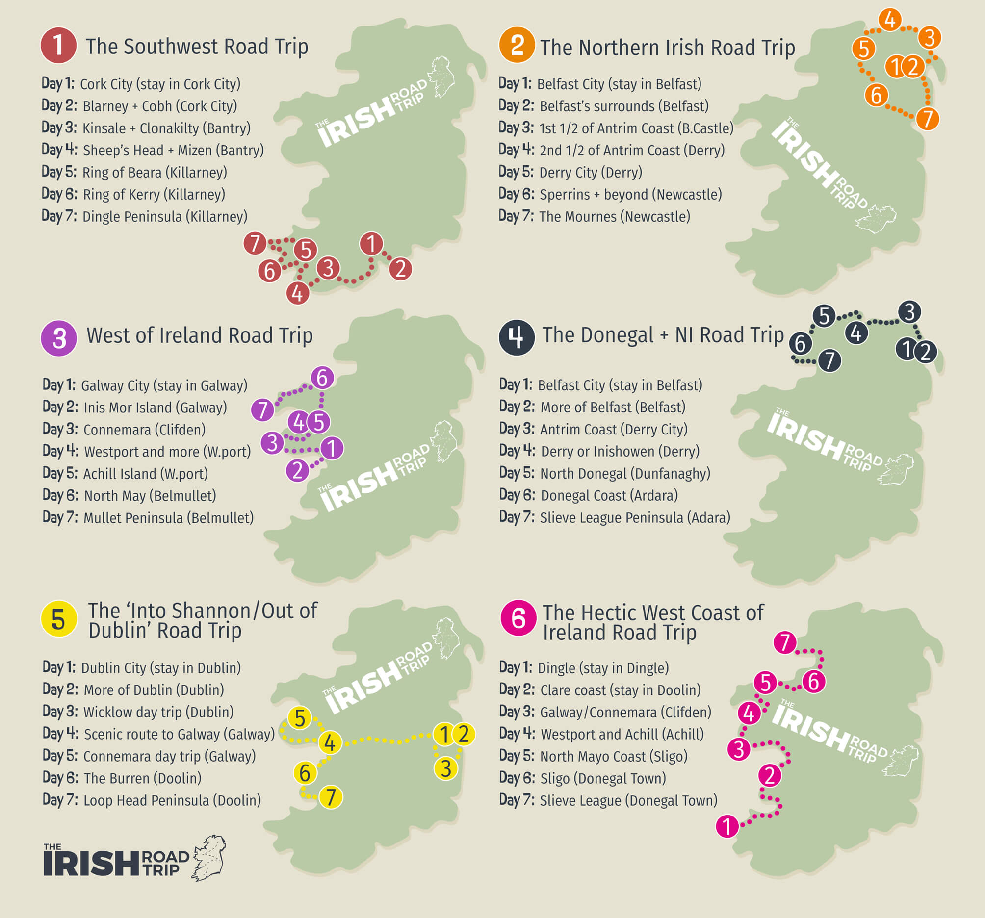
I’d always recommend weighing up different options when it comes do deciding what to do in Ireland for a week!
You’ve already seen my West Coast of Ireland itinerary, now here are some other options (you can see each on my map above):
- West of Ireland itinerary
- Southwest of Ireland itinerary
- Donegal and Northern Ireland itinerary
- Fly into Dublin and out of Shannon road trip
- Northern Ireland itinerary
Keith O’Hara has lived in Ireland for 35 years and has spent much of the last 13 creating what is now The Irish Road Trip guide. Over the years, the website has published thousands of meticulously researched Ireland travel guides, welcoming 40 million+ visitors along the way. In 2022, the Irish Road Trip team published the world’s largest collection of Irish Road Trip itineraries. Keith lives in Dublin with his dog Toby and finds writing in the 3rd person minus craic altogether.